
The 2004 Atlantic hurricane season was a very deadly, destructive, and active Atlantic hurricane season, with over 3,200 deaths and more than $61 billion in damage. More than half of the 16 tropical cyclones brushed or struck the United States. Due to the development of a Modoki El Niño – a rare type of El Niño in which unfavorable conditions are produced over the eastern Pacific instead of the Atlantic basin due to warmer sea surface temperatures farther west along the equatorial Pacific – activity was above average. The season officially began on June 1 and ended on November 30, though the season's last storm, Otto, dissipated on December 3, extending the season beyond its traditional boundaries. The first storm, Alex, developed offshore of the Southeastern United States on July 31, one of the latest dates on record to see the formation of the first system in an Atlantic hurricane season. It brushed the Carolinas and the Mid-Atlantic, causing one death and $7.5 million (2004 USD) in damage. Several storms caused only minor damage, including tropical storms Bonnie, Earl, Hermine, and Matthew. In addition, hurricanes Danielle, Karl, and Lisa, Tropical Depression Ten, Subtropical Storm Nicole and Tropical Storm Otto had no effect on land while tropical cyclones. The season was the first to exceed 200 units in accumulated cyclone energy (ACE) since 1995, mostly from Hurricane Ivan, which produced the highest ACE out of any storm this season. Ivan generated the second-highest ACE in the Atlantic, only behind the 1899 San Ciriaco Hurricane.

The 1999 Atlantic hurricane season was a fairly active season, mostly due to a persistent La Niña that developed in the latter half of 1998. It had five Category 4 hurricanes – the highest number recorded in a single season in the Atlantic basin, previously tied in 1933 and 1961, and later tied in 2005 and 2020. The season officially began on June 1, and ended on November 30. These dates conventionally delimit the period of each year when most tropical cyclones form in the Atlantic basin. The first storm, Arlene, formed on June 11 to the southeast of Bermuda. It meandered slowly for a week and caused no impact on land. Other tropical cyclones that did not affect land were Hurricane Cindy, Tropical Storm Emily, and Tropical Depression Twelve. Localized or otherwise minor damage occurred from Hurricanes Bret, Gert, and Jose, and tropical storms Harvey and Katrina.
The 1998 Atlantic hurricane season was a catastrophic and deadly Atlantic hurricane season, which had the highest number of storm-related fatalities in over 218 years and some of the costliest ever at the time. The season had above average activity, due to the dissipation of an El Niño event and transition to La Niña conditions. It officially began on June 1 and ended on November 30, dates which conventionally delimit the period during which most tropical cyclones form in the Atlantic Ocean. The season had a rather slow start, with no tropical cyclones forming in June. The first tropical cyclone, Tropical Storm Alex, developed on July 27, and the season's final storm, Hurricane Nicole, became extratropical on December 1.

Hurricane Michelle was the fifth costliest tropical cyclone in Cuban history and the strongest hurricane of the 2001 Atlantic hurricane season. The thirteenth named storm and seventh hurricane that year, Michelle developed from a tropical wave that had traversed into the western Caribbean Sea on October 29; the wave had initially moved off the coast of Africa 13 days prior. In its early developmental stages, the depression meandered over Nicaragua, later paralleling the Mosquito Coast before intensifying into tropical storm intensity on November 1; Michelle was upgraded to hurricane strength the following day. Shortly after, rapid intensification ensued within favorable conditions, with the storm's central barometric pressure dropping 51 mbar in 29 hours. After a slight fluctuation in strength, Michelle reached its peak intensity as a Category 4 hurricane with winds of 140 mph (230 km/h) and a minimum pressure of 933 mbar. This tied Michelle with 1999's Lenny as the fourth most powerful November hurricane on record in the Atlantic Basin, behind only the 1932 Cuba hurricane and 2020 Hurricanes Iota and Eta. At roughly the same time, the hurricane began to accelerate northeastward; this brought the intense hurricane to a Cuban landfall within the Bay of Pigs later that day. Crossing over the island, Michelle was weakened significantly, and was only a Category 1 hurricane upon reentry into the Atlantic Ocean. The hurricane later transitioned into an extratropical cyclone over The Bahamas on November 5, before being absorbed by a cold front the following day.

The 1981 Atlantic hurricane season featured direct or indirect impacts from nearly all of its 12 tropical or subtropical storms. Overall, the season was fairly active, with 22 tropical depressions, 12 of which became named storms. 7 of those reached hurricane status and a further 3 intensified into major hurricanes. The season officially began on June 1, 1981, and lasted until November 30, 1981. These dates conventionally delimit the period of each year when most tropical cyclones form in the Atlantic basin. However, tropical cyclogenesis can occur before these dates, as demonstrated with the development of two tropical depressions in April and Tropical Storm Arlene in May. At least one tropical cyclone formed in each month between April and November, with the final system, Subtropical Storm Three, becoming extratropical on November 17, 1981.

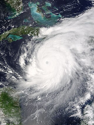
Hurricane Charley was the first of four separate hurricanes to impact or strike Florida during 2004, along with Frances, Ivan and Jeanne, as well as one of the strongest hurricanes ever to strike the United States. It was the third named storm, the second hurricane, and the second major hurricane of the 2004 Atlantic hurricane season. Charley lasted from August 9 to 15, and at its peak intensity it attained 150 mph (240 km/h) winds, making it a strong Category 4 hurricane on the Saffir–Simpson scale. It made landfall in Southwest Florida at maximum strength, making it the strongest hurricane to hit the United States since Hurricane Andrew struck Florida in 1992 and tied with Hurricane Ian as the strongest hurricane to hit southwest Florida in recorded history.

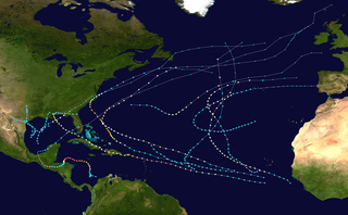
The 2005 Atlantic hurricane season was the most active on record in terms of number of tropical cyclones, until surpassed by the 2020 season. It featured 28 tropical or subtropical storms. The United States National Hurricane Center named 27 storms, exhausting the annual pre-designated list, requiring the use of six Greek letter names, and adding an additional unnamed subtropical storm during a post-season re-analysis. A record 15 storms attained hurricane status, with maximum sustained winds of at least 74 miles per hour (119 km/h). Of those, a record seven became major hurricanes, rated Category 3 or higher on the Saffir–Simpson scale. Four storms of this season became Category 5 hurricanes, the most of any season on record.

Hurricane Emily was a powerful early season tropical cyclone that caused significant damage across the Lesser Antilles, the Caribbean, and Mexico. The fifth named storm of the record-breaking 2005 Atlantic hurricane season, Emily was the only recorded Category 5 Atlantic hurricane to have formed in the month of July until Hurricane Beryl in 2024. It formed on July 11 from a tropical wave, which progressed westward across the Atlantic. Three days later, the hurricane struck Grenada before entering the eastern Caribbean Sea. After fluctuating in intensity, Emily strengthened to attain maximum sustained winds of 260 km/h (160 mph) on July 16 while passing southwest of Jamaica. Slight weakening occurred before Emily made landfall along Mexico's Yucatán Peninsula on July 18. Quickly crossing the peninsula, Emily emerged into the Gulf of Mexico and reorganized, making a second landfall in the Mexican state of Tamaulipas on July 20. It rapidly weakened and dissipated over land.

The 2008 Atlantic hurricane season was the most destructive Atlantic hurricane season since 2005, causing over 1,000 deaths and nearly $50 billion in damage. The season ranked as the third costliest ever at the time, but has since fallen to ninth costliest. It was an above-average season, featuring sixteen named storms, eight of which became hurricanes, and five which further became major hurricanes. It officially started on June 1 and ended on November 30. These dates conventionally delimit the period of each year when most tropical cyclones form in the Atlantic basin. However, the formation of Tropical Storm Arthur caused the season to start one day early. It was the only year on record in which a major hurricane existed in every month from July through November in the North Atlantic. Bertha became the longest-lived July tropical cyclone on record for the basin, the first of several long-lived systems during 2008.

Hurricane Rita was the most intense tropical cyclone on record in the Gulf of Mexico and the fourth-most intense Atlantic hurricane ever recorded. Part of the record-breaking 2005 Atlantic hurricane season, which included three of the top ten most intense Atlantic hurricanes in terms of barometric pressure ever recorded, Rita was the seventeenth named storm, tenth hurricane, and fifth major hurricane of the 2005 season. It was also the earliest-forming 17th named storm in the Atlantic until Tropical Storm Rene in 2020. Rita formed near The Bahamas from a tropical wave on September 18, 2005, that originally developed off the coast of West Africa. It moved westward, and after passing through the Florida Straits, Rita entered an environment of abnormally warm waters. Moving west-northwest, it rapidly intensified to reach peak winds of 180 mph (285 km/h), achieving Category 5 status on September 21. However, it weakened to a Category 3 hurricane before making landfall in Johnson's Bayou, Louisiana, between Sabine Pass, Texas and Holly Beach, Louisiana, with winds of 115 mph (185 km/h). Rapidly weakening over land, Rita degenerated into a large low-pressure area over the lower Mississippi Valley by September 26.

Hurricane Gordon was an erratic, long-lived, and catastrophic late-season hurricane of the 1994 Atlantic hurricane season. The twelfth and final tropical cyclone of the season, Gordon formed as a tropical depression in the southwestern Caribbean on November 8. Without strengthening, the depression made landfall on Nicaragua. Later on November 10, the system began to strengthen as it tracked further from land, and it quickly strengthened into Tropical Storm Gordon, the seventh named storm that season. Gordon also made landfalls in Jamaica and Cuba while a minimal tropical storm. It entered the southwestern Atlantic while resembling a subtropical cyclone. By the time it entered the Gulf of Mexico, the storm was fully tropical again. Tropical Storm Gordon later crossed the Florida Keys, and turning to the northeast it made landfall in Fort Myers, Florida. Gordon strengthened after it re-entered the Atlantic Ocean, becoming a hurricane on November 17. It briefly threatened North Carolina while turning to the northwest, although it turned to the south and weakened. Gordon deteriorated into a tropical depression and struck Florida again at that intensity on November 20. It turned to the north and dissipated the next day over South Carolina.

Hurricane Wilma was the most intense tropical cyclone in the Atlantic basin and the second-most intense tropical cyclone in the Western Hemisphere, both based on barometric pressure, after Hurricane Patricia in 2015. Wilma's rapid intensification led to a 24-hour pressure drop of 97 mbar (2.9 inHg), setting a new basin record. At its peak, Hurricane Wilma's eye contracted to a record minimum diameter of 2.3 mi (3.7 km). In the record-breaking 2005 Atlantic hurricane season, Wilma was the twenty-second storm, thirteenth hurricane, sixth major hurricane, fourth Category 5 hurricane, and the second costliest.

Hurricane Cindy was a tropical cyclone that made landfall in the U.S. state of Louisiana in July 2005. The third named storm of the 2005 Atlantic hurricane season, Cindy developed from a tropical wave on July 3, off the east coast of Mexico's Yucatán Peninsula. Soon after, it moved over land before emerging into the Gulf of Mexico. Cindy tracked toward the northern Gulf Coast and strengthened to reach maximum sustained winds of 75 mph (120 km/h), making it a Category 1 on the Saffir–Simpson scale. The hurricane struck near Grand Isle, Louisiana, on July 5 at peak intensity, but weakened by the time it made a second landfall along southern Mississippi. Cindy weakened over the southeastern United States and transitioned into an extratropical cyclone as it merged with a cold front on July 7. The remnants of Cindy produced an outbreak of 42 tornadoes across six states. Eventually, the remnants of Cindy moved into Atlantic Canada, dissipating on July 13 over the Gulf of St. Lawrence.

Hurricane Ernesto was the costliest tropical cyclone of the 2006 Atlantic hurricane season. The sixth tropical storm and first hurricane of the season, Ernesto developed from a tropical wave on August 24 in the eastern Caribbean Sea. Ernesto first affected the northern Caribbean, reaching minimal hurricane status near Haiti before weakening and moving across eastern Cuba as a tropical storm. Despite initial predictions for it to track through the eastern Gulf of Mexico as a major hurricane, Ernesto moved across eastern Florida as a weak tropical storm. After turning to the northeast, it re-intensified and made landfall on August 31 on the North Carolina coast just below hurricane status. Late the next day, Ernesto became extratropical after entering southern Virginia. The remnants spread moisture across the northeastern United States before dissipating over eastern Canada on September 4.

Hurricane Noel was a deadly tropical cyclone that carved a path of destruction across the Atlantic Ocean from the Caribbean Sea to Newfoundland in late October 2007. The sixteenth tropical depression, fourteenth named storm, and the sixth hurricane of the 2007 Atlantic hurricane season, Noel formed on October 27 from the interaction between a tropical wave and an upper-level low in the north-central Caribbean. It strengthened to winds of 60 mph (97 km/h) before making landfall on western Haiti and the north coast of eastern Cuba. Noel turned northward, and on November 1, it attained hurricane status. The hurricane accelerated northeastward after crossing the Bahamas, and on November 2, it transitioned into an extratropical cyclone.

Hurricane Marco caused significant flooding in the Greater Antilles and Central America, despite remaining well offshore. The thirteenth tropical cyclone, thirteenth named storm, and ninth hurricane of the 1996 Atlantic hurricane season, Marco developed in the western Caribbean Sea on November 16 after the interaction of a cold front and several tropical waves. Initially a tropical depression, it remained weak as it tracked southwestward and eventually southward. By November 19, the depression strengthened into Tropical Storm Marco, shortly before slowly curving in a general eastward direction. Marco briefly became a hurricane on November 20, though upper-level winds caused it to weaken back to a tropical storm later that day. The storm then tracked northeastward toward Hispaniola, but later become nearly stationary and curve eastward, then doubled-back to the west.

Tropical Storm Fay was an unusual tropical storm that moved erratically across the state of Florida and the Caribbean Sea. The sixth named storm of the 2008 Atlantic hurricane season, Fay formed from a vigorous tropical wave on August 15 over the Dominican Republic. It passed over the island of Hispaniola, into the Gulf of Gonâve, across the island of Cuba, and made landfall on the Florida Keys late in the afternoon of August 18 before veering into the Gulf of Mexico. It again made landfall near Naples, Florida, in the early hours of August 19 and progressed northeast through the Florida peninsula, emerging into the Atlantic Ocean near Melbourne on August 20. Extensive flooding took place in parts of Florida as a result of its slow movement. On August 21, it made landfall again near New Smyrna Beach, Florida, moving due west across the Panhandle, crossing Gainesville and Panama City, Florida. As it zigzagged from water to land, it became the first storm in recorded history to make landfall in Florida four times. Thirty-six deaths were blamed on Fay. The storm also resulted in one of the most prolific tropical cyclone related tornado outbreaks on record. A total of 81 tornadoes touched down across five states, three of which were rated as EF2. Fay would cause around $560 million in damages throughout its lifespan.
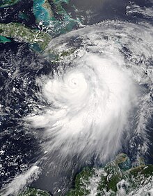
From September 8 to 14, 2004, Hurricane Ivan moved through the Caribbean Sea, affecting all of the Greater Antilles. Reaching peak winds of 165 mph (266 km/h), Ivan attained Category 5 strength on the Saffir-Simpson Hurricane Scale, the strongest possible category, on three times in the Caribbean. It first lashed the southern coasts of Puerto Rico and Hispaniola with high waves, killing five people in the Dominican Republic and Haiti; in the latter country, two others drowned due to storm flooding. The effects in Jamaica were among the worst from a tropical cyclone in the island's recorded history. The storm caused severe damage which left 18,000 people homeless. An estimated 17 people on the island were killed by Ivan.

Hurricane Matthew was a powerful tropical cyclone which caused catastrophic damage and a humanitarian crisis in Haiti, as well as widespread devastation in the southeastern United States. The deadliest Atlantic hurricane since Hurricane Stan in 2005, and the first Category 5 Atlantic hurricane since Felix in 2007, Matthew was the thirteenth named storm, fifth hurricane and second major hurricane of the 2016 Atlantic hurricane season. It caused extensive damage to landmasses in the Greater Antilles, and severe damage in several islands of the Bahamas which were still recovering from Joaquin, which had pounded the archipelago nearly a year earlier. Matthew also approached the southeastern United States, but stayed just offshore, paralleling the Florida coastline.


