Montgomery County, Alabama

Last updated

Montgomery County
Montgomery County Courthouse.JPG
Montgomery County Courthouse in Montgomery
Seal of Montgomery County, Alabama.png
Map of Alabama highlighting Montgomery County.svg
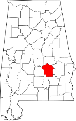
Location within the U.S. state of Alabama
Alabama in United States.svg
Alabama's location within the U.S.
Coordinates: 32°13′09″N86°12′34″W / 32.219166666667°N 86.209444444444°W / 32.219166666667; -86.209444444444
CountryFlag of the United States.svg United States
StateFlag of Alabama.svg  Alabama
FoundedDecember 6, 1816 [1]
Named for Lemuel P. Montgomery
Seat Montgomery
Largest cityMontgomery
Area
  Total
800 sq mi (2,000 km2)
  Land784 sq mi (2,030 km2)
  Water16 sq mi (40 km2)  2.0%
Population
 (2020)
  Total
228,954
  Estimate 
(2023)
224,980 Decrease2.svg
  Density290/sq mi (110/km2)
Time zone UTC−6 (Central)
  Summer (DST) UTC−5 (CDT)
Congressional district 2nd
Website www.mc-ala.org
  • County Number 03 on Alabama License Plates
  • One of three counties shuffled to the top 3 numbers because of population size
  • Largest County by population not shuffled to top 07 on Alabama License Plates

Montgomery County is a county located in the U.S. state of Alabama. As of the 2020 census, its population was 228,954, making it the seventh-most populous county in Alabama. [2] Its county seat is Montgomery, the state capital. [3] Montgomery County is included in the Montgomery Metropolitan Statistical Area.

Contents

History

Montgomery County was established by dividing Monroe County on December 6, 1816, by the Mississippi Territorial Legislature. [1] It is named for Lemuel P. Montgomery, a young U.S. Army officer killed at the Battle of Horseshoe Bend, the final battle of the Creek Indian war, which was waged concurrently with the War of 1812. [4]

The city of Montgomery, which is the county seat, is named for Richard Montgomery, an American Revolutionary War general killed in 1775 while attempting to capture Quebec City, Canada. [4]

Over much of the 19th century great wealth was derived from the cotton crop, with the Civil War producing a temporary setback. More lasting trouble came in 1914 with the arrival of the boll weevil, which became very destructive to the cotton harvest from 1915 on. [5] By the 1940s county farms earned more from cattle than cotton. [6]

Geography

According to the United States Census Bureau, the county has a total area of 800 square miles (2,100 km2), of which 784 square miles (2,030 km2) is land and 16 square miles (41 km2) (2.0%) is water. [7]

Major highways

Transit

Adjacent counties

National protected area

Demographics

Historical population
CensusPop.Note
1820 6,604
1830 12,69592.2%
1840 24,57493.6%
1850 29,71120.9%
1860 35,90420.8%
1870 43,70421.7%
1880 52,35619.8%
1890 56,1727.3%
1900 72,04728.3%
1910 82,17814.1%
1920 80,853−1.6%
1930 98,67122.0%
1940 114,42016.0%
1950 138,96521.5%
1960 169,21021.8%
1970 167,790−0.8%
1980 197,03817.4%
1990 209,0856.1%
2000 223,5106.9%
2010 229,3632.6%
2020 228,954−0.2%
2023 (est.)224,980 [8] −1.7%
U.S. Decennial Census [9]
1790–1960 [10] 1900–1990 [11]
1990–2000 [12] 2010–2020 [2]

2020 Census

Montgomery County, Alabama – Racial and ethnic composition
Note: the US Census treats Hispanic/Latino as an ethnic category. This table excludes Latinos from the racial categories and assigns them to a separate category. Hispanics/Latinos may be of any race.
Race / Ethnicity (NH = Non-Hispanic)Pop 2000 [13] Pop 2010 [14] Pop 2020 [15] % 2000% 2010% 2020
White alone (NH)107,85888,09973,35448.26%38.41%32.04%
Black or African American alone (NH)108,146124,928129,80148.39%54.47%56.69%
Native American or Alaska Native alone (NH)5305203640.24%0.23%0.16%
Asian alone (NH)2,1894,7927,9520.98%2.09%3.47%
Pacific Islander alone (NH)67841190.03%0.04%0.05%
Other race alone (NH)1781877220.08%0.08%0.32%
Mixed race or Multiracial (NH)1,8772,4395,9580.84%1.06%2.60%
Hispanic or Latino (any race)2,6658,31410,6841.19%3.62%4.67%
Total223,510229,363228,954100.00%100.00%100.00%

As of the 2020 census, there were 228,954 people, 93,223 households, and 56,961 families residing in the county. [16] The population density was 291.5 inhabitants per square mile (112.5/km2) There were 105,293 housing units.

2010 census

The 2010 census reported the following county population:

2000 census

As of the 2000 census, there were 223,510 persons, 86,068 households, and 56,804 families in the county. The population density was 283 persons per square mile (109 persons/km2). There were 95,437 housing units, at an average density of 121 units per square mile (47 units/km2). The racial makeup of the county (including Hispanics in the racial counts) was 48.85% White, 48.58% Black or African American, 0.99% Asian, 0.25% Native American, 0.03% Pacific Islander, 0.35% from other races, and 0.94% from two or more races. Hispanics and Latinos, of any race, made up 1.19% of the population.

There were 86,068 households, 32.20% of which included children under the age of 18, 43.80% were married couples living together, 18.60% had a female householder with no husband present, and 34.00% were non-families. Single-persons households were 29.50% of the total; 9.40% had someone living alone who was 65 years of age or older. The average household size was 2.46. The average family size was 3.06.

Persons younger than 18 were 25.80% of the population; those 18–24, 11.70%; 25–44, 29.80%; 45–64, 20.90%; and 65 and older, 11.80%. The median age was 34 years. For every 100 females, there were 90.80 males. For every 100 females aged 18 and over, there were 86.70 males.

The median income for a household in the county was $35,962, and the median income for a family was $44,669. Males had a median income of $32,018; females, $24,921. The per capita income for the county was $19,358. About 13.50% of families and 17.30% of the population were below the poverty line, including 25.10% of those under age 18 and 13.70% of those 65 and older.

Politics

Montgomery County is a strongly Democratic county like most of the Black Belt in Alabama. The last Republican to win the county was George H.W. Bush in 1992.

United States presidential election results for Montgomery County, Alabama [17]
Year Republican Democratic Third party(ies)
No.%No.%No.%
2024 30,47733.94%57,94664.53%1,3751.53%
2020 33,31133.60%64,52965.09%1,2991.31%
2016 34,00335.46%58,91661.45%2,9593.09%
2012 38,33237.56%63,08561.81%6500.64%
2008 42,03140.13%62,16659.35%5460.52%
2004 44,09749.19%45,16050.37%3930.44%
2000 38,82748.34%40,37150.26%1,1301.41%
1996 37,78447.98%38,38248.74%2,5783.27%
1992 40,74247.29%37,34243.34%8,0689.36%
1988 41,13158.43%28,70940.79%5510.78%
1984 43,32857.77%31,20641.61%4710.63%
1980 35,74553.75%28,01842.13%2,7414.12%
1976 29,36053.64%24,64145.02%7321.34%
1972 35,35371.86%12,72325.86%1,1212.28%
1968 6,74614.50%12,08825.98%27,69159.52%
1964 23,01575.47%00.00%7,48224.53%
1960 11,77854.91%9,42143.92%2491.16%
1956 8,72746.32%6,89036.57%3,22417.11%
1952 8,10246.22%9,23452.68%1931.10%
1948 80211.13%00.00%6,40288.87%
1944 3813.98%9,14395.62%380.40%
1940 2301.99%11,31197.74%320.28%
1936 2231.81%12,06197.80%480.39%
1932 4414.19%10,06695.57%260.25%
1928 3,11432.90%6,34767.06%30.03%
1924 2334.62%4,42287.70%3877.68%
1920 3144.63%6,41194.63%500.74%
1916 1063.07%3,31696.06%300.87%
1912 431.33%3,04794.10%1484.57%
1908 792.91%2,62196.54%150.55%
1904 501.96%2,49297.53%130.51%
1900 56715.06%3,04780.91%1524.04%
1896 97723.26%2,65363.17%57013.57%
1892 70.11%3,70257.02%2,78442.88%
1888 2,96644.41%3,71255.58%10.01%

Infrastructure inside Montgomery County includes both Interstate 85 and 65 along with shipping hubs on the Alabama River and rail hubs located in the City of Montgomery. The Montgomery Regional Airport also serves as a major airport for the State of Alabama and the Southeastern US for passenger service, military aviation, and commercial aviation.

Education

The Montgomery Public Schools headquarters and Montgomery County Board of Education is located at 307 S. Decatur Street in Montgomery. Montgomery Public Schools Headquarters.JPG
The Montgomery Public Schools headquarters and Montgomery County Board of Education is located at 307 S. Decatur Street in Montgomery.

Montgomery Public Schools operates public schools serving most of the county. However, Pike Road City School District operates public schools in Pike Road. Additionally Maxwell Air Force Base is zoned to Department of Defense Education Activity (DoDEA) schools. [18] The DoDEA operates Maxwell Air Force Base Elementary/Middle School. [19] For high school Maxwell AFB residents are zoned to Montgomery Public Schools facilities. [20]

The Montgomery City-County Public Library operates public libraries.

Universities/Colleges include:

Cultural sites

Montgomery County is home to many cultural and historic sites including:

Communities

City

Town

Unincorporated communities

See also

References

  1. 1 2 A Digest of the Laws of the State of Alabama: Containing The Statutes and Resolutions in Force at the end of the General Assembly in January, 1823. Published by Ginn & Curtis, J. & J. Harper, Printers, New-York, 1828. Title 10. Chapter VII. Pages 83-84. "An Act to divide the County of Monroe, and form a new County by the name of Montgomery—Passed December 6, 1816." (Internet Archive)
  2. 1 2 "State & County QuickFacts". United States Census Bureau. Retrieved March 15, 2024.
  3. "Find a County". National Association of Counties. Retrieved June 7, 2011.
  4. 1 2 Hardy, Michael C. (April 20, 2015). The Capitals of the Confederacy: A History. Arcadia Publishing Incorporated. p. 11. ISBN   9781625854322 . Retrieved September 26, 2017.
  5. https://www.nrcs.usda.gov/Internet/FSE_MANUSCRIPTS/alabama/montgomeryAL1926/montgomeryAL1926.pdf Soil Survey of Montgomery County, Alabama
  6. Flynt, Wayne (February 5, 2016). Poor But Proud. 6918: University of Alabama Press.{{cite book}}: CS1 maint: location (link)
  7. "2010 Census Gazetteer Files". United States Census Bureau. August 22, 2012. Retrieved August 22, 2015.
  8. "Annual Estimates of the Resident Population for Counties: April 1, 2020 to July 1, 2023" . Retrieved March 15, 2024.
  9. "U.S. Decennial Census". United States Census Bureau. Retrieved August 22, 2015.
  10. "Historical Census Browser". University of Virginia Library. Retrieved August 22, 2015.
  11. Forstall, Richard L., ed. (March 24, 1995). "Population of Counties by Decennial Census: 1900 to 1990". United States Census Bureau. Retrieved August 22, 2015.
  12. "Census 2000 PHC-T-4. Ranking Tables for Counties: 1990 and 2000" (PDF). United States Census Bureau. April 2, 2001. Retrieved August 22, 2015.
  13. "P004 Hispanic or Latino, and Not Hispanic or Latino by Race – 2000: DEC Summary File 1 – Montgomery County, Alabama". United States Census Bureau .
  14. "P2 Hispanic or Latino, and Not Hispanic or Latino by Race – 2010: DEC Redistricting Data (PL 94-171) – Montgomery County, Alabama". United States Census Bureau .
  15. "P2 Hispanic or Latino, and Not Hispanic or Latino by Race – 2020: DEC Redistricting Data (PL 94-171) – Montgomery County, Alabama". United States Census Bureau .
  16. "US Census Bureau, Table P16: Household Type". United States Census Bureau. Retrieved March 15, 2024.
  17. "Dave Leip's Atlas of U.S. Presidential Elections" . Retrieved November 21, 2016.
  18. "2020 CENSUS - SCHOOL DISTRICT REFERENCE MAP: Montgomery County, AL" (PDF). United States Census Bureau . Retrieved July 4, 2022. - Text listing: "Maxwell AFB School District" would mean the Department of Defense Education Activity (DoDEA) since that agency operates the on-base public schools.
  19. "Home". Department of Defense Education Activity . Retrieved July 4, 2022.
  20. "Maxwell AFB Community". Department of Defense Education Activity. Retrieved July 4, 2022.

Further reading

32°13′09″N86°12′34″W / 32.21917°N 86.20944°W / 32.21917; -86.20944