Chilton County, Alabama

Last updated • 6 min readFrom Wikipedia, The Free Encyclopedia

Chilton County
Chilton County Courthouse.jpg
Chilton County Courthouse in Clanton
Seal of Chilton County, Alabama.svg
Logo of Chilton County, Alabama.svg
Map of Alabama highlighting Chilton County.svg
Location within the U.S. state of Alabama
Alabama in United States.svg
Alabama's location within the U.S.
Coordinates: 32°50′43″N86°42′52″W / 32.8453°N 86.7144°W / 32.8453; -86.7144
CountryFlag of the United States.svg United States
StateFlag of Alabama.svg  Alabama
FoundedDecember 30, 1868
Named for William Parish Chilton, Sr.
Seat Clanton
Largest cityClanton
Area
  Total
701 sq mi (1,820 km2)
  Land693 sq mi (1,790 km2)
  Water7.9 sq mi (20 km2)  1.1%
Population
 (2020)
  Total
45,014
  Estimate 
(2023)
46,431 Increase2.svg
  Density64/sq mi (25/km2)
Time zone UTC−6 (Central)
  Summer (DST) UTC−5 (CDT)
Congressional district 6th
Website chiltoncounty.org
  • County Number 14 on Alabama Licence Plates

Chilton County is a county located in the central portion of the U.S. state of Alabama. As of the 2020 census, the population was 45,014. [1] The county seat is Clanton. Its name is in honor of William Parish Chilton, Sr. (1810–1871), a lawyer who became Chief Justice of the Alabama Supreme Court and later represented Montgomery County in the Congress of the Confederate States of America.

Contents

Chilton County is included in the Birmingham Metropolitan Statistical Area.

In 2010, the center of population of Alabama was located in Chilton County, near the city of Jemison, an area known as Jemison Division. [2]

The county is known for its peaches and its unique landscape. It is home to swamps, prairies, and mountains due to the foothills of the Appalachians which end in the county, the Coosa River basin, and its proximity to the Black Belt Prairie that was long a center of cotton production.

History

Baker County was established on December 30, 1868, named for Alfred Baker, with its county seat at Grantville. Residents of the county petitioned the Alabama legislature for the renaming of their county; it was not something forced upon them. On December 17, 1874, the petitioners accepted the suggestion of Chilton County, even though the Chief Justice had not lived within its boundaries. [3] In 1871, the county seat was moved to what is now Clanton after the Grantville courthouse burned.

In 1942, the U.S. Navy commissioned a new vessel, the USS Chilton, in honor of Chilton County.

Geography

According to the United States Census Bureau, the county has a total area of 701 square miles (1,820 km2), of which 693 square miles (1,790 km2) is land and 7.9 square miles (20 km2) (1.1%) is water. [4]

Major highways

Adjacent counties

National protected area

Demographics

Historical population
CensusPop.Note
1870 6,194
1880 10,79374.2%
1890 14,54934.8%
1900 16,52213.6%
1910 23,18740.3%
1920 22,770−1.8%
1930 24,5797.9%
1940 27,95513.7%
1950 26,922−3.7%
1960 25,693−4.6%
1970 25,180−2.0%
1980 30,61221.6%
1990 32,4586.0%
2000 39,59322.0%
2010 43,64310.2%
2020 45,0143.1%
2023 (est.)46,431 [5] 3.1%
U.S. Decennial Census [6]
1790–1960 [7] 1900–1990 [8]
1990–2000 [9] 2010–2020 [1]

2020 census

Chilton County, Alabama – Racial and ethnic composition
Note: the US Census treats Hispanic/Latino as an ethnic category. This table excludes Latinos from the racial categories and assigns them to a separate category. Hispanics/Latinos may be of any race.
Race / Ethnicity (NH = Non-Hispanic)Pop 2000 [10] Pop 2010 [11] Pop 2020 [12] % 2000% 2010% 2020
White alone (NH)33,89735,39534,87885.61%81.10%77.48%
Black or African American alone (NH)4,1314,1714,04010.43%9.56%8.97%
Native American or Alaska Native alone (NH)1111341120.28%0.31%0.25%
Asian alone (NH)651251760.16%0.29%0.39%
Pacific Islander alone (NH)21150.01%0.03%0.01%
Other race alone (NH)16341210.04%0.08%0.27%
Mixed race or Multiracial (NH)2193531,2640.55%0.81%2.81%
Hispanic or Latino (any race)1,1523,4204,4182.91%7.84%9.81%
Total39,59343,64345,014100.00%100.00%100.00%

As of the census of 2020, there were 45,014 people, 16,927 households, and 11,908 families residing in the county.

2010 census

According to the 2010 United States census, the population identifies by the following ethnicities:

Chilton County is the 23rd-richest county per capita income in Alabama. [13]

2000 census

As of the census, [14] of 2000, there were 39,593 people, 15,287 households, and 11,342 families residing in the county. The population density was 57 people per square mile (22 people/km2). There were 17,651 housing units at an average density of 25 units per square mile (9.7 units/km2). The racial makeup of the county was 86.71% White, 10.61% Black or African American, 0.28% Native American, 0.18% Asian, 0.02% Pacific Islander, 1.51% from other races, and 0.69% from two or more races. Nearly 2.91% of the population were Hispanic or Latino of any race.

There were 15,287 households, of which 34.40% had children under the age of 18 living with them, 60.10% were married couples living together, 10.50% had a female householder with no husband present, and 25.80% were non-families. Nearly 22.90% of all households were made up of individuals, and 10.20% had someone living alone who was 65 years of age or older. The average household size was 2.57, and the average family size was 3.00.

25.70% of the population were under the age of 18, 9.10% from 18 to 24, 29.00% from 25 to 44, 23.40% from 45 to 64, and 12.90% who were 65 years of age or older. The median age was 36 years. For every 100 females, there were 97.80 males. For every 100 females age 18 and over, there were 93.90 males.

The median household income was $32,588 and the median family income was $39,505. Males had a median income of $31,006 versus $21,275 for females. The per capita income for the county was $15,303. About 12.60% of families and 15.70% of the population were below the poverty line, including 19.40% of those under age 18 and 18.20% of those age 65 or over.

Education

Chilton County contains one public school district. There are approximately 7,700 students in public PK-12 schools in Chilton County. [15]

Districts

School districts include: [16]

Government

The County Commission is made up of seven members elected by cumulative vote (CV). "Chilton County adopted cumulative voting in 1988 as part of the settlement of a vote dilution lawsuit brought against its previous election system. According to the 1990 Census, African Americans constituted 9.9% of the county's voting age population." Although passage of the Voting Rights Act of 1965 enabled African Americans to register and vote, in Chilton County no African American was elected to the County Commission until the first cumulative voting election, held in 1988. [17]

African Americans in Alabama had been essentially disenfranchised by the 1901 state constitution, which required payment of a poll tax and qualification by a literacy test in order to register to vote. Discriminatory in practice as administered by white officials, this system excluded most blacks from the state's political system for decades in the 20th century before Congress passed the Voting Rights Act of 1965. After that, African Americans were able finally to register and vote in the county and state for the first time since the late 19th century. [17]

In counties in which there is a minority population and members are elected at-large or by single-member districts, minorities may be unable to elect representatives in a system dominated by the majority. The adoption of cumulative voting in Chilton County has enabled the minority to elect candidates of their choice by pooling their votes. Bobby Agee was elected as a Chilton County Commissioner in 1988 and again in the second cumulative voting election in 1992. [17] Cumulative voting depends on a multi-seat election, whether at-large or by district. "The cumulative options provide a minority of voters an opportunity to concentrate their support for a candidate or candidates more effectively than they can under the more traditional voting rules used in this country." [17] In 2014, the county commission had an African-American commissioner among its seven members. However, in 2018, the county commissioners were all white males. [18]

The commission hires a County Administrator to handle daily management of county business.

Chilton County is reliably Republican at the presidential level. The last Democrat to win the county in a presidential election is Jimmy Carter, who won it by a majority in 1976.

United States presidential election results for Chilton County, Alabama [19]
Year Republican Democratic Third party(ies)
No.%No.%No.%
2024 16,92085.61%2,69813.65%1450.73%
2020 16,08583.30%3,07315.91%1520.79%
2016 15,08182.10%2,91115.85%3772.05%
2012 13,93279.68%3,39719.43%1560.89%
2008 13,96078.49%3,67420.66%1510.85%
2004 12,82976.85%3,77822.63%860.52%
2000 10,06666.70%4,80631.84%2201.46%
1996 7,91055.40%5,35437.50%1,0147.10%
1992 8,12656.17%4,94634.19%1,3969.65%
1988 8,76169.41%3,82030.26%420.33%
1984 8,24370.53%2,93425.10%5114.37%
1980 6,61557.64%4,70641.00%1561.36%
1976 4,72545.50%5,55053.44%1101.06%
1972 7,34982.88%1,35615.29%1621.83%
1968 1,60218.00%5666.36%6,73475.65%
1964 5,20275.97%00.00%1,64524.03%
1960 3,20163.93%1,79835.91%80.16%
1956 3,13960.98%1,89136.73%1182.29%
1952 2,56352.91%2,26946.84%120.25%
1948 1,58444.38%00.00%1,98555.62%
1944 1,38541.02%1,98458.77%70.21%
1940 1,99541.99%2,74657.80%100.21%
1936 1,46936.23%2,56563.26%210.52%
1932 1,53247.09%1,66451.15%571.75%
1928 3,18669.37%1,40230.52%50.11%
1924 1,59563.19%84833.60%813.21%
1920 2,27369.11%96229.25%541.64%
1916 1,36359.31%88138.34%542.35%
1912 1406.23%88039.18%1,22654.59%
1908 89054.87%65640.44%764.69%
1904 64839.11%73844.54%27116.35%

Communities

Cities

Towns

Unincorporated communities

See also

Related Research Articles

<span class="mw-page-title-main">Clay County, Georgia</span> County in Georgia, United States

Clay County is a county located in the southwestern part of the U.S. state of Georgia. As of the 2020 census, the population was 2,848, making it the fourth-least populous county in Georgia. The county seat is Fort Gaines.

<span class="mw-page-title-main">Bibb County, Alabama</span> County in Alabama, United States

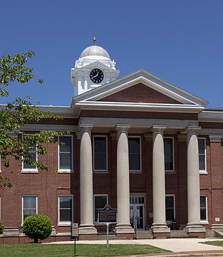
Bibb County is a county in the central portion of the U.S. state of Alabama. The county is a part of the Birmingham, AL Metropolitan Statistical Area, and is included in the ARC's definition of Appalachia. As of the 24th decennial 2020 census, its population was 22,293. The county seat is Centreville. The county is named in honor of William W. Bibb (1781–1820), the Governor of Alabama Territory (1817–1819) and the first Governor of Alabama. He is also the namesake for Bibb County, Georgia, where he began his political career. It is a "prohibition" or dry county; however, a few towns have become "wet" by allowing the sale of alcoholic beverages: Woodstock, West Blocton, Centreville, and Brent. The Bibb County Courthouse is located in the county seat of Centreville.

<span class="mw-page-title-main">Winston County, Alabama</span> County in Alabama, United States

Winston County is a county of the U.S. state of Alabama. As of the 2020 census, the population was 23,540. Its county seat is Double Springs. Known as Hancock County before 1858, the county is named in honor of John A. Winston, the fifteenth Governor of Alabama.

<span class="mw-page-title-main">Cleburne County, Alabama</span> County in Alabama, United States

Cleburne County is a county located in the east central portion of the U.S. state of Alabama. As of the 2020 census, the population was 15,056. Its county seat is Heflin. Its name is in honor of Patrick R. Cleburne of Arkansas who rose to the rank of major general in the Confederate States Army. The eastern side of the county borders the state of Georgia.

<span class="mw-page-title-main">Coosa County, Alabama</span> County in Alabama, United States

Coosa County is a county located in the east central portion of the U.S. state of Alabama. As of the 2020 census the population was 10,387. Its county seat is Rockford. Its name derives from a town of the Creek tribe and the Coosa River, which forms one of the county borders.

<span class="mw-page-title-main">Dallas County, Alabama</span> County in Alabama, United States

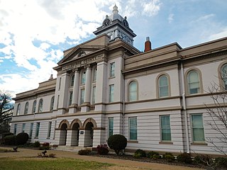
Dallas County is a county located in the central part of the U.S. state of Alabama. As of the 2020 census, its population was 38,462. The county seat is Selma. Its name is in honor of United States Secretary of the Treasury Alexander J. Dallas, who served from 1814 to 1816.

<span class="mw-page-title-main">Geneva County, Alabama</span> County in Alabama, United States

Geneva County is a county located in the southeastern part of the U.S. state of Alabama. As of the 2020 census, the population was 26,659. Its county seat is Geneva. The county was named after its county seat, which in turn was named after Geneva, New York which was named after Geneva, Switzerland, by Walter H. Yonge, an early town resident and Swiss native. Geneva County is a dry county. However, beer and wine are sold in the city limits of Geneva, Samson, Slocomb, and most recently in Hartford, after residents voted to become wet in a 2022 election.

<span class="mw-page-title-main">Jackson County, Alabama</span> County in Alabama, United States

Jackson County is the northeasternmost county in the U.S. state of Alabama. As of the 2020 census, the population was 52,579. The county seat is Scottsboro. The county was named for Andrew Jackson, general in the United States Army and afterward President of the United States of America. Jackson County is a prohibition or dry county, but three cities within the county are "wet", allowing alcohol sales. Jackson County comprises the Scottsboro, AL Micropolitan Statistical Area, and Jackson county is included in the Chattanooga–Cleveland–Dalton combined statistical area. It is the site of Russell Cave National Monument, an archeological site with evidence of 8,000 years of human occupation in the Southeast.

<span class="mw-page-title-main">Houston County, Alabama</span> County in Alabama, United States

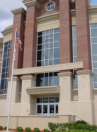
Houston County is a county located in the southeastern corner of the U.S. state of Alabama. As of the 2020 census the population was 107,202. Its county seat is Dothan, which is located on the border and partially in adjacent Henry County.

<span class="mw-page-title-main">Macon County, Alabama</span> County in Alabama, United States

Macon County is a county located in the east central part of the U.S. state of Alabama. As of the 2020 census, the population was 19,532. Its county seat is Tuskegee. Its name is in honor of Nathaniel Macon, a member of the United States Senate from North Carolina.

<span class="mw-page-title-main">Perry County, Alabama</span> County in Alabama, United States

Perry County is a county located in the Black Belt region in the central part of the U.S. state of Alabama. As of the 2020 census, the population was 8,511. Its county seat is Marion. The county was established in 1819 and is named in honor of Commodore Oliver Hazard Perry of Rhode Island and the United States Navy. As of 2020, Perry County was the only county in Alabama, and one of 40 in the United States, not to have access to any wired broadband connections.

<span class="mw-page-title-main">Randolph County, Alabama</span> County in Alabama, United States

Randolph County is a county on the central eastern border of the U.S. state of Alabama. As of the 2020 census, the population was 21,967. Its county seat is Wedowee. Its name is in honor of John Randolph, a member of the United States Senate from Virginia. Randolph County was a prohibition or dry county until 2012, when the citizens of Randolph County voted to repeal prohibition.

<span class="mw-page-title-main">Russell County, Alabama</span> County in Alabama, United States

Russell County is a county in the southeastern part of the U.S. state of Alabama. As of the 2020 census, the population was 59,183. Its county seat is Phenix City. Its name is in honor of Colonel Gilbert C. Russell, who fought in the wars against the Creek Indians.

<span class="mw-page-title-main">Shelby County, Alabama</span> County in Alabama, United States

Shelby County is a county located in the central portion of the U.S. state of Alabama. As of the 2020 census the population was 223,024, making it the sixth-most populous county in Alabama. The county seat is Columbiana. Its largest city is Alabaster. The county is named in honor of Isaac Shelby, Governor of Kentucky from 1792 to 1796 and again from 1812 to 1816. Shelby County is included in the Birmingham–Hoover, AL Metropolitan Statistical Area.

<span class="mw-page-title-main">Wilcox County, Alabama</span> County in Alabama, United States

Wilcox County is a county of the U.S. state of Alabama. As of the 2020 census, the population was 10,600. Its county seat is Camden.

<span class="mw-page-title-main">Klickitat County, Washington</span> County in Washington, United States

Klickitat County is a county located in the U.S. state of Washington. As of the 2020 census, the population was 22,735. The county seat and largest city is Goldendale. The county is named after the Klickitat tribe.

<span class="mw-page-title-main">Windsor County, Vermont</span> County in Vermont, United States

Windsor County is a county located in the U.S. state of Vermont. As of the 2020 census, the population was 57,753. The shire town is the town of Woodstock. The county's largest municipality is the town of Hartford.

<span class="mw-page-title-main">Clanton, Alabama</span> City in and county seat of Chilton County, Alabama

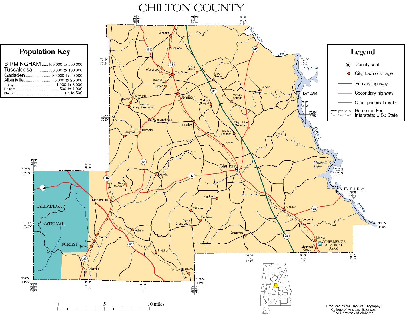
Clanton is a city in Chilton County, Alabama, United States. It is part of the Birmingham–Hoover–Cullman Combined Statistical Area. At the 2020 census, the population was 14,545. The city is the county seat of Chilton County. Clanton is near the site of the geographic center of the U.S. state of Alabama.

<span class="mw-page-title-main">Jemison, Alabama</span> City in Alabama, United States

Jemison is a city in Chilton County, Alabama, United States. At the 2020 census, the population was 2,642. The center of population of Alabama is located outside of Jemison, an area known as Jemison Division.

<span class="mw-page-title-main">Eunola, Alabama</span> Census-designated place in Alabama, United States

Eunola is a census-designated place and former town in Geneva County, Alabama, United States. It is part of the Dothan, Alabama Metropolitan Statistical Area. At the 2020 census, the population was 284. The town was disincorporated in 2007.

References

  1. 1 2 "State & County QuickFacts". United States Census Bureau. Retrieved September 13, 2023.
  2. "Centers of Population by State: 2010". United States Census Bureau. Archived from the original on January 3, 2014. Retrieved May 15, 2014.
  3. "Central Alabama Genealogy" . Retrieved April 30, 2012.
  4. "2010 Census Gazetteer Files". United States Census Bureau. August 22, 2012. Retrieved August 22, 2015.
  5. "Annual Estimates of the Resident Population for Counties: April 1, 2020 to July 1, 2023". United States Census Bureau. Retrieved March 27, 2024.
  6. "U.S. Decennial Census". United States Census Bureau. Retrieved August 22, 2015.
  7. "Historical Census Browser". University of Virginia Library. Archived from the original on August 11, 2012. Retrieved August 22, 2015.
  8. Forstall, Richard L., ed. (March 24, 1995). "Population of Counties by Decennial Census: 1900 to 1990". United States Census Bureau. Retrieved August 22, 2015.
  9. "Census 2000 PHC-T-4. Ranking Tables for Counties: 1990 and 2000" (PDF). United States Census Bureau. April 2, 2001. Retrieved August 22, 2015.
  10. "P004 Hispanic or Latino, and Not Hispanic or Latino by Race – 2000: DEC Summary File 1 – Chilton County, Alabama". United States Census Bureau .
  11. "P2 Hispanic or Latino, and Not Hispanic or Latino by Race – 2010: DEC Redistricting Data (PL 94-171) – Chilton County, Alabama". United States Census Bureau .
  12. "P2 Hispanic or Latino, and Not Hispanic or Latino by Race – 2020: DEC Redistricting Data (PL 94-171) – Chilton County, Alabama". United States Census Bureau .
  13. "50 Richest Counties in Alabama by per Capita Income". January 7, 2014.
  14. "U.S. Census website". United States Census Bureau . Retrieved May 14, 2011.
  15. "Search for Public School Districts - Chilton County, AL". National Center for Education Statistics . Institute of Education Sciences . Retrieved October 2, 2022.
  16. "2020 Census - School District Reference Map: Chilton County, AL" (PDF). United States Census Bureau . Retrieved October 2, 2022. Text list.
  17. 1 2 3 4 Jason Kirksey, Richard Engstrom and Edward Still, "Cumulative Voting in an Alabama County/ Shaw v. Reno and New Election Systems", "Chapter Three: Full Representation in Local Elections", Voting and Democracy Report: 1995, in Voting Rights Review of the Southern Regional Council, reprinted at FairVote website
  18. "Chilton County Commission".
  19. "Dave Leip's Atlas of U.S. Presidential Elections" . Retrieved November 16, 2016.

32°50′43″N86°42′52″W / 32.84528°N 86.71444°W / 32.84528; -86.71444