
Mobile Bay is a shallow inlet of the Gulf of Mexico, lying within the state of Alabama in the United States. Its mouth is formed by the Fort Morgan Peninsula on the eastern side and Dauphin Island, a barrier island on the western side. The Mobile River and Tensaw River empty into the northern end of the bay, making it an estuary. Several smaller rivers also empty into the bay: Dog River, Deer River, and Fowl River on the western side of the bay, and Fish River on the eastern side. Mobile Bay is the fourth largest estuary in the United States with a discharge of 62,000 cubic feet (1,800 m3) of water per second. Annually, and often several times during the summer months, the fish and crustaceans will swarm the shallow coastline and shore of the bay. This event, appropriately named a jubilee, draws a large crowd because of the abundance of fresh, easily caught seafood.

Baldwin County is a county located in the southwestern part of the U.S. state of Alabama, on the Gulf coast. It is one of only two counties in Alabama that border the Gulf of Mexico, along with Mobile County. As of the 2020 census, the population was 231,767. The county seat is Bay Minette. The county is named after senator Abraham Baldwin, though he never lived in what is now Alabama.

Bay Minette is a city in and the county seat of Baldwin County, Alabama, United States. As of the 2010 census, the population of the city was 8,044.

Daphne is a city in Baldwin County, Alabama, United States, on the eastern shoreline of Mobile Bay. The city is located along I-10, 11 miles east of Mobile and 170 miles southwest of the state capital of Montgomery. The 2010 United States Census lists the population of the city as 21,570, making Daphne the most populous city in Baldwin County. It is a principal city of the Daphne-Fairhope-Foley metropolitan area, which includes all of Baldwin County.

Fairhope is a city in Baldwin County, Alabama, United States, located on the eastern shoreline of Mobile Bay. The 2020 Census lists the population of the city as 22,477. Fairhope is a principal city of the Daphne-Fairhope-Foley metropolitan area, which includes all of Baldwin County.

Loxley is a city in Baldwin County, Alabama, United States. As of the 2010 census, the population of the town was 1,632. It is part of the Daphne-Fairhope-Foley metropolitan area. Loxley is becoming a popular location for the expansion of the suburbs from Daphne and Spanish Fort, Alabama, because it is served by an Interstate 10 exit and is almost directly between the cities of Mobile, Alabama, and Pensacola, Florida.

Point Clear is an unincorporated census-designated place (CDP) in Baldwin County, Alabama, United States. As of the 2010 census, the population was 2,125. It is part of the Daphne-Fairhope-Foley metropolitan area.

Spanish Fort is a city in Baldwin County, Alabama, United States, located on the eastern shore of Mobile Bay. The 2020 census lists the population of the city as 10,049. It is a suburb of Mobile and is part of the Daphne-Fairhope-Foley metropolitan area.
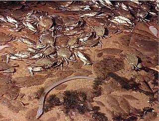
Jubilee is the name used locally for a natural phenomenon that occurs sporadically on the shores of Mobile Bay, a large body of water on Alabama's Gulf Coast. During a jubilee many species of crab and shrimp, as well as flounder, eels, and other demersal fish will leave deeper waters and swarm—in large numbers and very high density—in a specific, shallower coastal area of the bay. A jubilee is a celebrated event in Mobile Bay, and it attracts large crowds, many drawn by the promise of abundant and easy-to-catch seafood.

U.S. Route 98 is an east–west United States Highway in the Southeastern United States that runs from western Mississippi to southern Florida. It was established in 1933 as a route between Pensacola and Apalachicola, Florida, and has since been extended westward into Mississippi and eastward across the Florida Peninsula. It runs along much of the Gulf Coast between Mobile, Alabama, and Crystal River, Florida, including extensive sections closely following the coast between Mobile and St. Marks, Florida. The highway's western terminus is with US 84 in Natchez, Mississippi. Its eastern terminus is Palm Beach, Florida, at State Road A1A (SR A1A) near the Mar-a-Lago resort.

Area code 251 is a telephone area code in the North American Numbering Plan (NANP) for southwestern Alabama, serving Mobile, Baldwin, and Washington counties and parts of six other counties. It was created on June 18, 2001, as a split from area code 334. In order to allow people time to reprogram electronics such as computers, cell phones, pagers and fax machines, use of the 334 area code continued in the 251 areas through January 7, 2002.

The Mobile Metropolitan Area comprises Mobile and Washington counties in the southwest corner of Alabama in the United States. As of the 2020 census the metropolitan area had a population of 430,197. The Mobile metropolitan area is the third-largest metropolitan area in the state of Alabama, after Birmingham and Huntsville.

Bon Secour is an unincorporated community in Baldwin County, Alabama, United States. It lies along the eastern coastline of Bon Secour Bay. Bon Secour is over 35 miles (56 km) due east of the Alabama–Mississippi state line, near Gulf Shores, and over 45 miles (72 km) west of Pensacola, Florida. The name "Bon Secour" derives from the French phrase meaning "safe harbor" due to the secluded location on the inside coast of the Fort Morgan peninsula of southern Alabama.

Interstate 10 (I-10) is a part of the Interstate Highway System that runs from Santa Monica, California, to Jacksonville, Florida. In Alabama, the Interstate Highway runs 66.269 miles (106.650 km) from the Mississippi state line near Grand Bay east to the Florida state line at the Perdido River. I-10 is the primary east–west highway of the Gulf Coast region of Alabama. The highway connects Mobile, the largest city in South Alabama, with Pascagoula, Mississippi, to the west and Pensacola, Florida, to the east. Within the state, the highway connects Mobile and Mobile County with the Baldwin County communities of Daphne and Fairhope. I-10 connects Mobile and Baldwin County by crossing the northern end of Mobile Bay and the southern end of the Mobile-Tensaw River Delta via the George Wallace Tunnel in Mobile and the Jubilee Parkway viaduct system between Mobile and Daphne.

State Route 181 is a 18.235-mile-long (29.346 km) route in Baldwin County in the southwestern part of the state. The southern terminus of the route is at its junction with US 98 near Magnolia Springs. The northern terminus of the route is at its junction with US 31, near Spanish Fort.
Fort Morgan, also known as Fort Bowyer, is an unincorporated community in Baldwin County, Alabama, United States. It is west of Gulf Shores on Mobile Point. Mobile Point extends from Gulf Shores to the west, towards historic Fort Morgan at the tip of the peninsula.
Malbis is an unincorporated community in Baldwin County, Alabama, United States. The community lies at the crossroads of U.S. 90 and Alabama State Route 181 just south and north of I-10. Portions of the settlement are today within the city limits of Daphne. The incorporated city of Loxley lies to the east, and Spanish Fort to the north.

The Baldwin County Board of Education oversees most public schools in Baldwin County, Alabama, and is based in Bay Minette, Alabama. The Board serves the entire county. Over 30,000 students are within the supervision of the Board. 3,400 employees including 2,100 classroom teachers, serve the students at its campuses. The Board of Education is the largest single employer in Baldwin County.
Central Baldwin is a colloquial term referring to an area of Baldwin County, Alabama along Alabama State Highway 59. The area begins at the Interstate 10 exit in Loxley, Alabama including Robertsdale, Alabama and ending with Summerdale, Alabama. The unofficial boundary is generally considered to be the public school district served by Robertsdale High School. The term began to be used by most people in the area with the creation of Central Baldwin Middle School in the late 1990s. Although students in Summerdale attend Foley High School rather than Robertsdale High School it is generally considered a part of the Central Baldwin region.

The Grand Hotel in Point Clear, Alabama, overlooking Mobile Bay, is a historic hotel originally built in 1847. It is listed on the National Registry of the Historic Hotels of America and has been added to the Autograph Collection by Marriott. The original hotel was two-stories with 40 guest rooms. As of 2020, the Grand Hotel boasts over 400 rooms across five buildings, including an extensive spa area of 20,000 square feet.