Tallapoosa County, Alabama

Last updated

Tallapoosa County
Talladega County Courthouse.jpg
County courthouse in Dadeville
Map of Alabama highlighting Tallapoosa County.svg
Location within the U.S. state of Alabama
Alabama in United States.svg
Alabama's location within the U.S.
Coordinates: 32°51′41″N85°47′50″W / 32.8614°N 85.7972°W / 32.8614; -85.7972
CountryFlag of the United States.svg United States
StateFlag of Alabama.svg  Alabama
FoundedDecember 18, 1832 [1]
Named for Tallapoosa River
Seat Dadeville
Largest city Alexander City
Area
  Total766 sq mi (1,980 km2)
  Land717 sq mi (1,860 km2)
  Water50 sq mi (100 km2)  6.5%
Population
 (2020)
  Total41,311
  Estimate 
(2023)
40,677 Decrease2.svg
  Density54/sq mi (21/km2)
Time zone UTC−6 (Central)
  Summer (DST) UTC−5 (CDT)
Congressional district 3rd
Website www.tallaco.com
  • County Number 62 on Alabama Licence Plates

Tallapoosa County is located in the east-central portion of the U.S. state of Alabama. [1] As of the 2020 census, the population was 41,311. [2] Its county seat is Dadeville. [3] Its largest city is Alexander City.

Contents

Etymology

The name Tallapoosa is of Creek origin; many Creek villages were located along the banks of the lower river before Indian Removal in the 19th century. Tallapoosa County, Alabama is named after the Tallapoosa River, which may mean "pulverized rock" in the Choctaw language. Tallapoosa is of Creek origin and may mean "grandmother town" in the Muscogee language. The Tallapoosa branch of the Muscogee tribe is considered one of the oldest groups in the Southeast. The river was a major population center for the Creek Indians before the early 19th century.

History

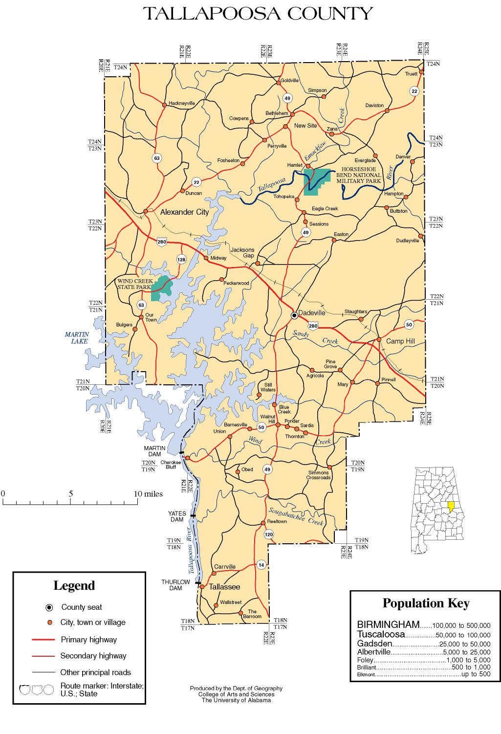
In 1832, Tallapoosa County was created from lands ceded by the Creek Indians in the Treaty of Cusseta. The first county seat was the Creek town of Okfuskee. The forced removal of the Creeks in 1836 and 1837 was followed by a frantic gold rush, bringing a flood of profit seekers and settlers.

Established on December 18, 1832. [1] Tallapoosa County's southwest strip of the county was detached from Tallapoosa County to become a portion of Elmore County when it was established on February 15, 1866.

The Battle of Horseshoe Bend was fought in the territory that would become Tallapoosa County in 1814. This battle effectively ended the Creek War.

Geography

According to the United States Census Bureau, the county has a total area of 766 square miles (1,980 km2), of which 717 square miles (1,860 km2) is land and 50 square miles (130 km2) (6.5%) is water. [4] The county is located in the Piedmont region of the state.

The county is intersected by the Tallapoosa River. [5]

Major highways

Adjacent counties

National protected area

Demographics

Historical population
CensusPop.Note
1840 6,444
1850 15,584141.8%
1860 23,82752.9%
1870 16,963−28.8%
1880 23,40138.0%
1890 25,4608.8%
1900 29,67516.6%
1910 31,0344.6%
1920 29,744−4.2%
1930 31,1884.9%
1940 35,27013.1%
1950 35,074−0.6%
1960 35,007−0.2%
1970 33,840−3.3%
1980 38,76614.6%
1990 38,8260.2%
2000 41,4756.8%
2010 41,6160.3%
2020 41,311−0.7%
2023 (est.)40,677 [6] −1.5%
U.S. Decennial Census [7]
1790–1960 [8] 1900–1990 [9]
1990–2000 [10] 2010–2020 [2]

2020 Census

Tallapoosa County, Alabama – Racial and Ethnic Composition
(NH = Non-Hispanic)
Note: the US Census treats Hispanic/Latino as an ethnic category. This table excludes Latinos from the racial categories and assigns them to a separate category. Hispanics/Latinos may be of any race.
Race / EthnicityPop 2000 [11] Pop 2010 [12] Pop 2020 [13] % 2000% 2010% 2020
White alone (NH)30,34228,83828,25273.16%69.30%68.39%
Black or African American alone (NH)10,48811,05010,36625.29%26.55%25.09%
Native American or Alaska Native alone (NH)107119840.26%0.29%0.20%
Asian alone (NH)741972220.18%0.47%0.54%
Pacific Islander alone (NH)3200.01%0.00%0.00%
Some Other Race alone (NH)522910.01%0.05%0.22%
Mixed Race/Multi-Racial (NH)2143461,1520.52%0.83%2.79%
Hispanic or Latino (any race)2421,0421,1440.58%2.50%2.77%
Total41,47541,61641,311100.00%100.00%100.00%

As of the 2020 United States census, there were 41,311 people, 16,205 households, and 11,183 families residing in the county.

2010 census

As of the census of 2010, there were 41,616 people, 16,985 households, and 11,762 families living in the county. The population density was 58 inhabitants per square mile (22 inhabitants/km2). There were 22,111 housing units at an average density of 31 units per square mile (12 units/km2). The racial makeup of the county was 69.9% White, 26.6% Black or African American, 0.3% Native American, 0.5% Asian, 0% Pacific Islander, 1.7% from other races, and 1.0% from two or more races. Nearly 2.5% of the population were Hispanic or Latino of any race. [14] There were 16,985 households, 25.6% had children under the age of 18 living with them, 48.4% were married couples living together, 15.9% had a female householder with no husband present, and 30.8% were non-families. Nearly 27.2% of households were made up of individuals, and 11.4% were one person aged 65 or older. The average household size was 2.42, and the average family size was 2.91.

The age distribution was 22.2% under the age of 18, 8.0% from 18 to 24, 23.3% from 25 to 44, 29.2% from 45 to 64, and 17.3% 65 or older. The median age was 42.4 years. For every 100 females, there were 94.2 males. For every 100 females age 18 and over, there were 95.8 males.

The median household income was $36,904 and the median family income was $47,918. Males had a median income of $34,625 versus $28,616 for females. The per capita income for the county was $22,542. About 13.4% of families and 17.5% of the population were below the poverty line, including 27.8% of those under age 18 and 9.1% of those age 65 or over.

2000 census

As of the census of 2000. there were 41,475 people, 16,656 households, and 11,809 families living in the county. The population density was 58 inhabitants per square mile (22 inhabitants/km2). There were 20,510 housing units at an average density of 29 units per square mile (11 units/km2). The racial makeup of the county was 73.48% White, 25.36% Black or African American, 0.26% Native American, 0.18% Asian, 0.01% Pacific Islander, 0.17% from other races, and 0.54% from two or more races. Nearly 0.58% of the population were Hispanic or Latino of any race. [15] There were 16,656 households, 29.90% had children under the age of 18 living with them, 53.00% were married couples living together, 14.30% had a female householder with no husband present, and 29.10% were non-families. Nearly 26.50% of households were made up of individuals, and 11.60% were one person aged 65 or older. The average household size was 2.44, and the average family size was 2.94.

The age distribution was 24.20% under the age of 18, 7.60% from 18 to 24, 26.70% from 25 to 44, 24.90% from 45 to 64, and 16.60% 65 or older. The median age was 39 years. For every 100 females, there were 90.50 males. For every 100 females age 18 and over, there were 86.10 males.

The median household income was $30,745 and the median family income was $38,148. Males had a median income of $28,557 versus $19,885 for females. The per capita income for the county was $16,909. About 13.50% of families and 16.60% of the population were below the poverty line, including 24.30% of those under age 18 and 15.60% of those age 65 or over.

Government

United States presidential election results for Tallapoosa County, Alabama [16]
Year Republican Democratic Third party
No.%No.%No.%
2020 14,96371.28%5,85927.91%1690.81%
2016 13,59469.76%5,51928.32%3731.91%
2012 12,39665.76%6,31933.52%1360.72%
2008 13,11667.92%6,06331.40%1320.68%
2004 12,39269.03%5,45130.36%1090.61%
2000 9,80560.33%6,18338.04%2651.63%
1996 7,62751.48%6,07140.98%1,1177.54%
1992 8,14052.67%5,70336.90%1,61310.44%
1988 8,50263.93%4,59834.58%1981.49%
1984 9,04566.19%4,45832.62%1631.19%
1980 5,95843.80%7,26053.37%3852.83%
1976 5,23739.79%7,61457.84%3122.37%
1972 8,53578.71%2,11319.49%1951.80%
1968 1,20510.19%1,33111.26%9,28578.55%
1964 5,53076.14%00.00%1,73323.86%
1960 2,15028.11%5,46071.39%380.50%
1956 1,87926.68%5,07072.00%931.32%
1952 1,18719.00%5,05580.89%70.11%
1948 1566.31%00.00%2,31893.69%
1944 1363.92%3,32695.88%70.20%
1940 1393.11%4,32596.65%110.25%
1936 1413.74%3,62596.10%60.16%
1932 1383.90%3,39195.87%80.23%
1928 1,25740.46%1,84959.51%10.03%
1924 10.06%1,71399.59%60.35%
1920 26910.54%2,25788.44%261.02%
1916 1296.27%1,89291.98%361.75%
1912 844.56%1,58686.06%1739.39%
1908 1046.32%1,34381.59%19912.09%
1904 23410.99%1,79184.08%1054.93%

Communities

Cities

Towns

Census-designated places

Unincorporated communities

Education

School districts in the county include: [17]

See also

Related Research Articles

<span class="mw-page-title-main">Clay County, Alabama</span> County in Alabama, United States

Clay County is a county in the east central part of the U.S. state of Alabama. As of the 2020 census the population was 14,236. Its county seat is Ashland. Its name is in honor of Henry Clay, famous American statesman, member of the United States Senate from Kentucky and United States Secretary of State in the 19th century. It was the last dry county in Alabama with no wet cities within its boundaries, until a vote on March 1, 2016, approved the sale of alcohol in Lineville and Ashland.

<span class="mw-page-title-main">Bullock County, Alabama</span> County in Alabama, United States

Bullock County is a county of the U.S. state of Alabama. As of the 2020 census, the population was 10,357. Union Springs was chosen as the county seat in 1867, and presently is the county's only incorporated city. The county was named for Confederate Army Colonel Edward C. Bullock who was a state senator and outspoken secessionist who died during the American Civil War.

<span class="mw-page-title-main">Butler County, Alabama</span> County in Alabama, United States

Butler County is a county located in the south central portion of the U.S. state of Alabama. As of the 2020 census, the population was 19,051. Its county seat is Greenville. Its name is in honor of Captain William Butler, who was born in Virginia and fought in the Creek War, and who was killed in May 1818.

<span class="mw-page-title-main">Chambers County, Alabama</span> County in Alabama, United States

Chambers County is a county located in the east central portion of the U.S. state of Alabama. As of the 2020 census the population was 34,772. Its county seat is LaFayette. Its largest city is Valley. Its name is in honor of Henry H. Chambers, who served as a United States Senator from Alabama.

<span class="mw-page-title-main">Cherokee County, Alabama</span> County in Alabama, United States

Cherokee County, Alabama is a county located in the northeastern part of the U.S. state of Alabama. As of the 2020 census, the population was 24,971. Its county seat is Centre. The county is named for the Cherokee tribe.

<span class="mw-page-title-main">Coosa County, Alabama</span> County in Alabama, United States

Coosa County is located in the east central portion of the U.S. state of Alabama. As of the 2020 census the population was 10,387. Its county seat is Rockford. Its name derives from a town of the Creek tribe and the Coosa River, which forms one of the county borders.

<span class="mw-page-title-main">Crenshaw County, Alabama</span> County in Alabama, United States

Crenshaw County is a county located in the south central portion of the U.S. state of Alabama. It is located immediately south of the Montgomery metropolitan area. As of the 2020 census, the population was 13,194. Its county seat is Luverne. Its name is in honor of an Alabama judge, Anderson Crenshaw.

<span class="mw-page-title-main">Elmore County, Alabama</span> County in Alabama, United States

Elmore County is a county located in the east central portion of the U.S. state of Alabama. As of the 2020 census, the population was 87,977. Its county seat is Wetumpka. Its name is in honor of General John A. Elmore.

<span class="mw-page-title-main">Lee County, Alabama</span> County in Alabama, United States

Lee County is a county located in east central Alabama. As of the 2020 census the population was 174,241. The county seat is Opelika, and the largest city is Auburn. The county was established in 1866 and is named for General Robert E. Lee (1807–1870), who served as General in Chief of the Armies of the Confederate States in 1865. Lee County comprises the Auburn-Opelika, AL Metropolitan Statistical Area, which is included in the Columbus-Auburn-Opelika, GA-AL Combined Statistical Area.

<span class="mw-page-title-main">Macon County, Alabama</span> County in Alabama, United States

Macon County is a county located in the east central part of the U.S. state of Alabama. As of the 2020 census, the population was 19,532. Its county seat is Tuskegee. Its name is in honor of Nathaniel Macon, a member of the United States Senate from North Carolina.

<span class="mw-page-title-main">Marshall County, Alabama</span> County in Alabama, United States

Marshall County is a county of the state of Alabama, United States. As of the 2020 census the population was 97,612. Its county seat is Guntersville. A second courthouse is in Albertville. Its name is in honor of John Marshall, famous Chief Justice of the United States. Marshall County is a dry county, with the exception of the five cities of Albertville, Arab, Grant, Guntersville, and Boaz. Marshall County comprises the Albertville, AL Micropolitan Statistical Area, which is also included in the Huntsville-Decatur-Albertville, AL Combined Statistical Area.

<span class="mw-page-title-main">Randolph County, Alabama</span> County in Alabama, United States

Randolph County is a county on the central eastern border of the U.S. state of Alabama. As of the 2020 census, the population was 21,967. Its county seat is Wedowee. Its name is in honor of John Randolph, a member of the United States Senate from Virginia. Randolph County was a prohibition or dry county until 2012, when the citizens of Randolph County voted to repeal prohibition.

<span class="mw-page-title-main">Talladega County, Alabama</span> County in Alabama, United States

Talladega County is one of the sixty-seven counties located in the east central portion of the U.S. state of Alabama. As of the 2020 census, the population was 82,149. Its county seat is Talladega.

<span class="mw-page-title-main">Walker County, Alabama</span> County in Alabama, United States

Walker County is a county located in the central portion of the U.S. state of Alabama. As of the 2020 census, the population was 65,342. Its county seat is Jasper. Its name is in honor of John Williams Walker, the first U.S. senator elected from Alabama.

<span class="mw-page-title-main">Polk County, Georgia</span> County in Georgia, United States

Polk County is a county located in the northwestern part of the U.S. state of Georgia. As of the 2020 census, the population was 42,853. The county seat is Cedartown. The county was created on December 20, 1851, by an act of the Georgia General Assembly and named after James K. Polk, the eleventh President of the United States.

<span class="mw-page-title-main">Shorter, Alabama</span> Town in Alabama, United States

Shorter is a town in Macon County, Alabama, United States. At the 2020 census the population was 385, down from 474 at the 2010 census. According to the 1990 U.S. Census records, it was incorporated in 1984.

<span class="mw-page-title-main">Camp Hill, Alabama</span> Town in Alabama, United States

Camp Hill is a town in Tallapoosa County, Alabama, United States. It was incorporated in 1895. At the 2010 census the population was 1,014, down from 1,273 in 2000. Camp Hill is the home to Southern Preparatory Academy.

<span class="mw-page-title-main">Dadeville, Alabama</span> County seat of Tallapoosa County

Dadeville is a city in and the county seat of Tallapoosa County, Alabama, United States. At the 2010 census the population was 3,230, up from 3,212 in 2000.

<span class="mw-page-title-main">Tallapoosa, Georgia</span> City in Georgia, United States

Tallapoosa is a city in Haralson County, Georgia. The population was 3,170 at the 2010 census, up from 2,789 at the 2000 census.

<span class="mw-page-title-main">Tallapoosa, Missouri</span> City in Missouri, United States

Tallapoosa is a city in New Madrid County, Missouri, United States. The population was 78 at the 2020 census.

References

  1. 1 2 3 "ACES Tallapoosa County Office" (links/history), Alabama Cooperative Extension System (ACES), 2007, webpage: ACES-Tallapoosa.
  2. 1 2 "State & County QuickFacts". United States Census Bureau. Retrieved September 12, 2023.
  3. "Find a County". National Association of Counties. Retrieved June 7, 2011.
  4. "2010 Census Gazetteer Files". United States Census Bureau. August 22, 2012. Retrieved August 22, 2015.
  5. Ripley, George; Dana, Charles A., eds. (1879). "Tallapoosa, an E. county of Alabama"  . The American Cyclopædia .
  6. "Annual Estimates of the Resident Population for Counties: April 1, 2020 to July 1, 2023". United States Census Bureau. Retrieved March 27, 2024.
  7. "U.S. Decennial Census". United States Census Bureau. Retrieved August 22, 2015.
  8. "Historical Census Browser". University of Virginia Library. Retrieved August 22, 2015.
  9. Forstall, Richard L., ed. (March 24, 1995). "Population of Counties by Decennial Census: 1900 to 1990". United States Census Bureau. Retrieved August 22, 2015.
  10. "Census 2000 PHC-T-4. Ranking Tables for Counties: 1990 and 2000" (PDF). United States Census Bureau. April 2, 2001. Retrieved August 22, 2015.
  11. "P004 HISPANIC OR LATINO, AND NOT HISPANIC OR LATINO BY RACE – 2000: DEC Summary File 1 – Tallapoosa County, Alabama". United States Census Bureau .
  12. "P2 HISPANIC OR LATINO, AND NOT HISPANIC OR LATINO BY RACE – 2010: DEC Redistricting Data (PL 94-171) – Tallapoosa County, Alabama". United States Census Bureau .
  13. "P2 HISPANIC OR LATINO, AND NOT HISPANIC OR LATINO BY RACE - 2020: DEC Redistricting Data (PL 94-171) – Tallapoosa County, Alabama". United States Census Bureau .
  14. "U.S. Census website". United States Census Bureau . Retrieved August 11, 2015.
  15. "U.S. Census website". United States Census Bureau . Retrieved May 14, 2011.
  16. "Dave Leip's Atlas of U.S. Presidential Elections" . Retrieved February 21, 2021.
  17. "2020 CENSUS - SCHOOL DISTRICT REFERENCE MAP: Tallapoosa County, AL" (PDF). United States Census Bureau . Retrieved July 31, 2022. - Text list

32°51′41″N85°47′50″W / 32.86139°N 85.79722°W / 32.86139; -85.79722