
Tallapoosa County is a county located in the east-central portion of the U.S. state of Alabama. As of the 2020 census, the population was 41,311. Its county seat is Dadeville. Its largest city is Alexander City.

The Battle of Horseshoe Bend, was fought during the War of 1812 in the Mississippi Territory, now central Alabama. On March 27, 1814, United States forces and Indian allies under Major General Andrew Jackson defeated the Red Sticks, a part of the Creek Indian tribe who opposed American expansion, effectively ending the Creek War.

The Creek War was a regional conflict between opposing Native American factions, European powers, and the United States during the early 19th century. The Creek War began as a conflict within the tribes of the Muscogee, but the United States quickly became involved. British traders and Spanish colonial officials in Florida supplied the Red Sticks with weapons and equipment due to their shared interest in preventing the expansion of the United States into regions under their control.

John Williams was an American lawyer, soldier, and statesman, operating primarily out of Knoxville, Tennessee, in the first part of the 19th century. He represented Tennessee in the United States Senate from 1815 to 1823, when he lost reelection to Andrew Jackson. Williams also served as colonel of the 39th U.S. Infantry Regiment during the Creek Wars, and played a key role in Jackson's victory at the Battle of Horseshoe Bend in 1814.

Shiloh National Military Park preserves the American Civil War Shiloh and Corinth battlefields. The main section of the park is in the unincorporated community of Shiloh, about nine miles (14 km) south of Savannah, Tennessee, with additional areas located in the city of Corinth, Mississippi, 23 miles (37 km) southwest of Shiloh and the Parker's Crossroads Battlefield in the city of Parkers Crossroads, Tennessee. The Battle of Shiloh began a six-month struggle for the key railroad junction at Corinth. Afterward, Union forces marched from Pittsburg Landing to take Corinth in a May siege, then withstood an October Confederate counter-attack.

The Coosa River is a tributary of the Alabama River in the U.S. states of Alabama and Georgia. The river is about 280 miles (450 km) long.
Red Sticks —the name deriving from the red-painted war clubs of some Native American Creek—refers to an early 19th century traditionalist faction of Muscogee Creek people in the Southeastern United States. Made up mostly of Creek of the Upper Towns that supported traditional leadership and culture, as well as the preservation of communal land for cultivation and hunting, the Red Sticks arose at a time of increasing pressure on Creek territory by European American settlers. Creek of the Lower Towns were closer to the settlers, had more mixed-race families, and had already been forced to make land cessions to the Americans. In this context, the Red Sticks led a resistance movement against European American encroachment and assimilation, tensions that culminated in the outbreak of the Creek War in 1813. Initially a civil war among the Creek, the conflict drew in United States state forces while the nation was already engaged in the War of 1812 against the British.

William Weatherford, also known after his death as Red Eagle, was a Creek chief of the Upper Creek towns who led many of the Red Sticks actions in the Creek War (1813–1814) against Lower Creek towns and against allied forces of the United States.

The Tallapoosa River runs 265 miles (426 km) from the southern end of the Appalachian Mountains in Georgia, United States, southward and westward into the Appalachian foothills in Alabama. It is formed by the confluence of McClendon Creek and Mud Creek in Paulding County, Georgia. Lake Martin at Dadeville, Alabama is a large and popular water recreation area formed by a dam on the river. The Tallapoosa joins the Coosa River about 10 miles (16 km) northeast of Montgomery near Wetumpka to form the Alabama River.
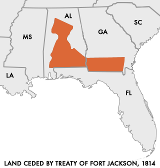
The Treaty of Fort Jackson was signed on August 9, 1814 at Fort Jackson near Wetumpka, Alabama following the defeat of the Red Stick resistance by United States allied forces at the Battle of Horseshoe Bend.

Menawa, first called Hothlepoya, was a Muscogee (Creek) chief and military leader. He was of mixed race, with a Creek mother and a fur trader father of mostly Scots ancestry. As the Creek had a matrilineal system of descent and leadership, his status came from his mother's clan.

The Fort Mims massacre took place on August 30, 1813, at a fortified homestead site 35-40 miles north of Mobile, Alabama, during the Creek War. A large force of Creek Indians belonging to the Red Sticks faction, under the command of Peter McQueen and William Weatherford, stormed the fort and defeated the militia garrison.

Junaluska, was a leader of Cherokee who resided in towns in western North Carolina in the early 19th century. He fought alongside Andrew Jackson at the Battle of Horseshoe Bend during the War of 1812/Creek War. In the course of the battle he saved Jackson's life, an act he reportedly regretted later in life.

The Colonel John Williams House in Knoxville, Tennessee, United States, was built in 1825–1826 by the slaves of Melinda White Williams, wife of Colonel John Williams, while he was away serving as Chargé d'Affaires to Guatemala for President John Quincy Adams. The home is designed in the Federal style, with a noteworthy pediment with a fanlight at the roofline.

Fort Toulouse and Fort Jackson are two forts that shared the same site at the fork of the Coosa River and the Tallapoosa River, near Wetumpka, Alabama.

Fort Williams was a supply depot built in early 1814 in preparation for the Battle of Horseshoe Bend. It was located in Alabama on the southeast shore where Cedar Creek meets the Coosa River, near Talladega Springs.

Fort Strother was a stockade fort at Ten Islands in the Mississippi Territory, in what is today St. Clair County, Alabama. It was located on a bluff of the Coosa River, near the modern Neely Henry Dam in Ragland, Alabama. The fort was built by General Andrew Jackson and several thousand militiamen in November 1813, during the Creek War and was named for Captain John Strother, Jackson's chief cartographer.

Dudleyville, also known as Pittsborough, is an unincorporated community in Tallapoosa County, Alabama, United States. Dudleyville was named for Peter Dudley, who established the first trading post in the area. The town was incorporated on February 2, 1839. A post office was operated in Dudleyville from 1836 to 1907. Major Lemuel Montgomery, the first American soldier killed in the Battle of Horseshoe Bend, was formerly buried in the Dudleyville cemetery, before his grave was moved to Horseshoe Bend National Military Park. Abram Mordecai, a trader who installed the first cotton gin in Alabama, lived for a time in Dudleyville. It was here that Albert J. Pickett visited him in 1847 and gathered information from him to use in his History of Alabama. County Line Baptist Church, which is located east of Dudleyville, is listed on the National Register of Historic Places.
John Gordon, was an American pioneer, Indian trader, planter, and militia captain in several Indian wars. Part of the post-Revolutionary War settlement of the trans-Appalachian frontier, Gordon was an early settler in the Nashville, Tennessee area. He gained notability and rank in the Tennessee Militia, fighting against the Creeks and Seminoles for Andrew Jackson, during the War of 1812. Jackson referred to him as his "Captain of the Spies."

Fort Decatur was an earthen fort established in March 1814 on the banks of the Tallapoosa River as part of the Creek War and the larger War of 1812. The fort was located on the east bank of the Tallapoosa River, near the modern community of Milstead. Fort Decatur was also located near the Creek town of Tukabatchee. It was most likely named for Stephen Decatur.


