Lake Guntersville State Park is a publicly owned recreation area located on the far north side of the city of Guntersville in Marshall County, Alabama. The state park occupies 5,909 acres (2,391 ha) on the eastern shore of Guntersville Lake, a 69,000-acre (28,000 ha) impoundment of the Tennessee River. The park features resort facilities and is managed by the Alabama Department of Conservation and Natural Resources.

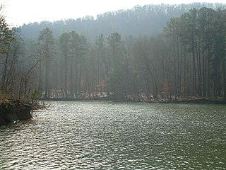
Buck's Pocket State Park is publicly owned recreation area located on Sand Mountain in the northeast corner of the U.S. state of Alabama, 2 miles (3.2 km) north of the community of Grove Oak. The state park occupies 2,000 acres (810 ha) surrounding a natural pocket (canyon) of the Appalachian Mountain chain along South Sauty Creek, an upstream tributary on the east side of Guntersville Lake. The park is known for the sweeping views of its rugged, seemingly untouched landscape provided from the heights of Point Rock.

Oak Mountain State Park is a publicly owned recreation area located approximately 20 miles (32 km) south of Birmingham in the northeast quadrant of the city of Pelham, Alabama, United States. It is the state's largest state park at 9,940 acres (4,020 ha) and is home to the Alabama Wildlife Center, Oak Mountain Interpretive Center, and Oak Mountain BMX Track. Park activities include hiking, swimming, camping, fishing, horseback riding, and golf. The park is managed by the Alabama Department of Conservation and Natural Resources.

Blue Springs State Park is a publicly owned recreation area located seven miles (11 km) east of Clio in Blue Springs, Barbour County, Alabama. The 103-acre (42 ha) state park features a clear blue, natural underground spring that pumps 3,600 US gallons (14,000 l) of water per hour into two concrete-ringed swimming pools.

Lake Tahoe–Nevada State Park is a state park comprising multiple management units and public recreation areas on the northeast shores of Lake Tahoe in the U.S. state of Nevada. The park covers approximately 14,301 acres (5,787 ha). The Marlette Lake Water System, which is listed on the National Register of Historic Places and as a Historic Civil Engineering Landmark, lies within park boundaries.

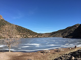
South Fork State Recreation Area is a state park unit of the state of Nevada covering nearly four thousand acres, located five miles (8.0 km) due south of Elko. The park comprises the 1,650-acre (670 ha) South Fork Reservoir and surrounding marsh, meadowlands, and hills.
Spring Valley State Park is a public recreation area adjoining the 65-acre (26 ha) Eagle Valley Reservoir in eastern Nevada near the border with the state of Utah. The state park is located at the east end of Nevada State Route 322, 20 miles (32 km) east of the town of Pioche and near the village of Ursine.

Wild Horse State Recreation Area is a public recreation area located on the northeast shore of Wild Horse Reservoir, approximately 67 miles (108 km) north of Elko, Nevada. The 120-acre (49 ha) park is a popular destination for fishing, and especially ice fishing, on the reservoir, which was created in 1937 and enlarged to cover 2,830 acres (1,150 ha) with the creation of a new dam in 1969. In addition to year-round fishing, the park offers opportunities for camping, picnicking, boating, ice skating, sledding, snowmobiling, and skiing.

Cheaha State Park is a publicly owned recreation area located in northern Clay and southwestern Cleburne counties in Alabama. The park's 2,799 acres (1,133 ha) include Cheaha Mountain, the highest point in the state. The park adjoins Talladega National Forest and is managed by the Alabama Department of Conservation and Natural Resources. It is Alabama's oldest continuously operating state park. Facilities include lodgings, a restaurant, campsites, and hiking trails.

Chewacla State Park is a publicly owned recreation area in Auburn, Lee County, Alabama, occupying 696 acres (282 ha) to the south of Interstate 85. The state park's central feature, 26-acre (11 ha) Lake Chewacla, provides opportunities for fishing, swimming, and non-motorized boating.
Chickasaw State Park is a locally managed public recreation area located on U.S. Route 43 approximately 4 miles (6.4 km) north of Linden in Marengo County, Alabama. The 520-acre (210 ha) state park was developed in the 1930s by members of the Civilian Conservation Corps on property that the state had owned since 1819. It was one of several Alabama state parks that either closed or saw curtailment of services in 2015 following state budget cuts.

Florala City Park, formerly Florala State Park, is a 40-acre (16 ha) public recreation area in Florala, Alabama. The park wraps around the Alabama side of Lake Jackson, a 500-acre (200 ha) lake that straddles the Alabama-Florida state line.
Frank Jackson State Park is a publicly owned recreation area that wraps around Lake Frank Jackson and forms the northwesternmost portion of the city of Opp, Alabama. The 2,050-acre (830 ha) state park offers facilities for fishing, boating, hiking, and camping.
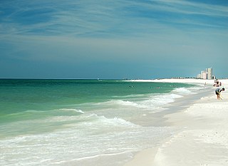
Gulf State Park is a public recreation area on the Gulf of Mexico in the city of Gulf Shores in southern Baldwin County, Alabama. The state park's 6,500 acres (2,600 ha) mostly encompass the land behind the Gulf Shores beach community, between Highway 59 and SH 161, with the west end extending further south to a wide beach area. In addition to beaches, the park includes marshland, boggy tea-colored streams, pine forests, and three spring-fed, fresh-water lakes: Lake Shelby, Middle Lake, and Little Lake. The park is managed by the Alabama Department of Conservation and Natural Resources, with park enforcement rangers providing around-the-clock security and enforcing anti-littering regulations.

Lake Lurleen State Park is a publicly owned recreation area located on U.S. Highway 82 approximately 9 miles (14 km) northwest of Northport in Tuscaloosa County, Alabama. The state park's 1,625 acres (658 ha) include 250-acre (100 ha) Lake Lurleen and a 23-mile (37 km) trail system. It is operated by the Alabama Department of Conservation and Natural Resources.
Lakepoint State Park is a publicly owned recreation area located on the far north side of the city of Eufaula. The state park encompasses 1,220 acres (490 ha) on the western shore of Lake Eufala, a 45,000-acre (18,000 ha) impoundment of the Chattahoochee River. The park adjoins Eufaula National Wildlife Refuge and is managed by the Alabama Department of Conservation and Natural Resources.

Meaher State Park is a publicly owned recreation area located on Big Island, an island at the north end of Mobile Bay that lies within the city limits of Spanish Fort, Alabama. The state park occupies 1,327 acres (537 ha) along the shoreline of Ducker Bay, at the junction of Mobile Bay and the Mobile-Tensaw River Delta. It is surrounded by wetlands of the Mobile Bay estuary. The park is accessed from Battleship Parkway, known locally as the "Causeway," and is managed by Alabama Department of Conservation and Natural Resources.
Paul M. Grist State Park is a public recreation area located 17 miles (27 km) north of Selma operated by the government of Dallas County, Alabama. The park offers water activities on a 100-acre (40 ha) lake as well as facilities for camping and picnicking.
Wind Creek State Park is a publicly owned recreation area located 7 miles (11 km) south of Alexander City, Alabama, on the western side of Lake Martin, a 41,000-acre (17,000 ha) reservoir on the Tallapoosa River. The state park occupies 1,445 acres (585 ha) and is managed by the Alabama Department of Conservation and Natural Resources.
The Alabama Department of Conservation and Natural Resources (ADCNR) is the state agency responsible for the conservation and management of Alabama's natural resources including state parks, state lands, wildlife and aquatic resources. ADCNR also issues hunting and fishing licenses for the state. The department promotes wise stewardship and enjoyment of the state's natural resources through five divisions: Marine Police, Marine Resources, State Lands, State Parks and Wildlife and Freshwater Fisheries. Supporting those divisions are seven support sections: Accounting, Diversity and Recruiting, Engineering, Information and Education, Information Technology, Legal, and Personnel and Payroll.


