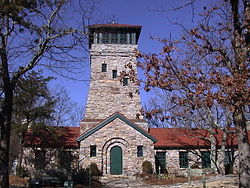
State parks are parks or other protected areas managed at the sub-national level within those nations which use "state" as a political subdivision. State parks are typically established by a state to preserve a location on account of its natural beauty, historic interest, or recreational potential. There are state parks under the administration of the government of each U.S. state, some of the Mexican states, and in Brazil. The term is also used in the Australian states of Victoria and New South Wales. [1] The equivalent term used in Canada, Argentina, South Africa, and Belgium, is provincial park. Similar systems of local government maintained parks exist in other countries, but the terminology varies.
State parks are thus similar to national parks, but under state rather than federal administration. Similarly, local government entities below state level may maintain parks, e.g., regional parks or county parks. In general, state parks are smaller than national parks, with a few exceptions such as Anza-Borrego Desert State Park in California, and Wood-Tikchik State Park in Alaska, the largest state park in the United States.
In addition to preserving natural landscapes and providing recreational opportunities, many state parks also serve as important educational resources. They often offer guided tours, interpretive programs, and exhibits that help visitors learn about the local flora, fauna, geology, and cultural history of the area. These programs are designed not only to enhance the visitor experience but also to promote conservation awareness and encourage responsible enjoyment of natural resources. [2]
There are 6,792 state park units in the United States, according to the National Association of State Park Directors (NASPD). [3] There are some 813 million annual visits to the country's state parks. [3] The NASPD further counts over 43,000 miles (69,000 km) of trail, 217,367 campsites, and 8,277 cabins and lodges across U.S. state parks. [3] The largest state park system in the United States is Alaska State Parks, with over 100 sites encompassing 3.3 million acres. [4]
Many states include designations beyond "state park" in their state parks systems. Other designations might be state recreation areas, state beaches, and state nature reserves. Some state park systems include long-distance trails and historic sites. To encourage tourism in rural areas, several states have simple lodges, inns, hotels, or motels (usually with a restaurant) for lodging at some parks. These typically use "Resort" in the name, such as "_____ Resort State Park" in West Virginia state parks and "_____ State Resort Park" in neighboring Kentucky state parks, which has 17 such resort parks, the most of any state. Other states use the Resort name inconsistently (like DeGray Lake Resort State Park, the only one out of three resorts in Arkansas state parks), or have only one such park (South Carolina state parks' Hickory Knob State Resort Park), or do not use the designation at all (such as the lodges of Georgia state parks). The term "lodge" may also refer to a hiking lodge, essentially a large cabin for hikers rather than a large facility with private rooms and a restaurant. Other lodging may include yurts and tipis.
Not all parks owned by a state are necessarily part of its state-park system, such as Stone Mountain Park near Atlanta. Some Texas state parks are a land lease from the U.S. government, while Mackinac National Park was handed down to become the first of the Michigan state parks. As with national parks, facilities at state parks are often leased to concessionaires to operate. Breaks Interstate Park is operated under an interstate compact by Virginia state parks, although it is also one of the Kentucky state parks, straddling both sides of the state line. Other multi-state parks are legally two separate parks with the same name and more informal cooperation between them.
The title of oldest state park in the United States is claimed by Niagara Falls State Park in New York, established in 1885. [5] [6] Several public parks previously or currently maintained at the state level pre-date it. [7] Indian Springs State Park has been operated continuously by the state of Georgia as a public park since 1825, although it did not gain the title "State Park" until 1931. [8] In 1864 Yosemite Valley and Mariposa Grove were ceded by the federal government to California [7] until Yosemite National Park was proclaimed in 1890. [9] In 1878 Wisconsin set aside a vast swath of its northern forests as "The State Park" but, needing money, sold most of it to lumber companies within 20 years. [10] Mackinac National Park was established in 1875 as the second U.S. national park before being converted to a state park in 1895. The first state park with the designation of "state park" was Itasca State Park in Minnesota, established in 1891. [11]
Many state park systems date to the 1930s, when around 800 state parks (and several national ones) across the country were developed with assistance from federal job-creation programs like the Civilian Conservation Corps and Works Progress Administration. [12]
The National Park Service (NPS) is an agency of the United States federal government, within the US Department of the Interior. The service manages all national parks; most national monuments; and other natural, historical, and recreational properties, with various title designations. The United States Congress created the agency on August 25, 1916, through the National Park Service Organic Act. Its headquarters is in Washington, D.C., within the main headquarters of the Department of the Interior.
Niagara Falls State Park is located in the City of Niagara Falls in Niagara County, New York, United States. The park, recognized as the oldest state park in the United States, contains the American Falls, the Bridal Veil Falls, and a portion of the Horseshoe Falls.
The protected areas of the United States are managed by an array of different federal, state, tribal and local level authorities and receive widely varying levels of protection. Some areas are managed as wilderness, while others are operated with acceptable commercial exploitation. As of 2022, the 42,826 protected areas covered 1,235,486 km2 (477,024 sq mi), or 13 percent of the land area of the United States. This is also one-tenth of the protected land area of the world. The U.S. also had a total of 871 National Marine Protected Areas, covering an additional 1,240,000 sq mi (3,200,000 km2), or 26 percent of the total marine area of the United States.
Starved Rock State Park is a state park in the U.S. state of Illinois, characterized by the many canyons within its 2,630 acres (1,064 ha). Located just southeast of the village of Utica, in Deer Park Township, LaSalle County, Illinois, along the south bank of the Illinois River, the park hosts over two million visitors annually, the most for any Illinois state park.
Monte Sano State Park is a public recreation area and mountaintop retreat encompassing 2,140 acres (870 ha) on the eastern portion of the top and slopes of Monte Sano Mountain on the east side of Huntsville, Alabama. The state park has 1930s-era, Civilian Conservation Corps–built rustic cottages, hiking trails and picnic areas with scenic overlooks, and modern campsites. It is managed by the Alabama Department of Conservation and Natural Resources.
Chickasaw National Recreation Area is a national recreation area in the foothills of the Arbuckle Mountains in south-central Oklahoma near Sulphur in Murray County. It includes the former Platt National Park and Arbuckle Recreation Area.
The North Shore of Lake Superior runs from Duluth, Minnesota, United States, at the western end of the lake, to Thunder Bay and Nipigon, Ontario, Canada, in the north, to Sault Ste. Marie, Ontario in the east. The shore is characterized by alternating rocky cliffs and cobblestone beaches, with forested hills and ridges through which scenic rivers and waterfalls descend as they flow to Lake Superior.
The National Wilderness Preservation System (NWPS) of the United States protects federally managed wilderness areas designated for preservation in their natural condition. Activity on formally designated wilderness areas is coordinated by the National Wilderness Preservation System. Wilderness areas are managed by four federal land management agencies: the National Park Service, the U.S. Forest Service, the U.S. Fish and Wildlife Service, and the Bureau of Land Management.
The Heritage Conservation and Recreation Service (HCRS) was an agency within the United States Department of the Interior which subsumed its functions from the National Park Service and Bureau of Outdoor Recreation. It was created under the Carter administration by order of the Secretary of the Interior on January 25, 1978. HCRS, a non-land managing agency, was responsible for assuring the identification, protection, and beneficial use of important cultural, natural, and recreational American resources. HCRS offered grant assistance, technical information and guidance to those in the public and private sectors involved in conservation or recreation projects. Under the Reagan administration the HCRS was abolished by Secretarial Order 3060 on February 19, 1981, and absorbed into the National Park Service.
Mount Greylock State Reservation is public recreation and nature preservation area on and around Mount Greylock, the highest point in the U.S. state of Massachusetts. The park covers some 12,000 acres (4,900 ha) in the towns of Lanesborough, North Adams, Adams, Cheshire, Williamstown and New Ashford, Massachusetts. It was created in 1898 as Massachusetts' first public land for the purpose of forest preservation.
Walter J. Hayes State Park is a public recreation area covering 654 acres (265 ha) on the southeast corner of Wamplers Lake in the Irish Hills region of the state of Michigan. Most of the state park lies within Lenawee County with a small portion extending into Jackson and Washtenaw counties in the Round Lake area. The park offers access to 796-acre (322 ha) Wamplers Lake and completely surrounds 100-acre (40 ha) Round Lake, which connects to Wamplers Lake via a channel navigable by smaller boats. Other scenic lakes including Evans Lake and Sand Lake as well as chains of smaller lakes lie nearby. The park is traversed by Michigan Route 124 north of its intersection with US Highway 12.
P. H. Hoeft State Park is a public recreation area on the shores of Lake Huron, four miles (6.4 km) northwest of Rogers City on US 23 in Presque Isle County, Michigan. The park was added to the National Register of Historic Places in 2009.
Cuivre River State Park is a public recreation area covering more than 6,400 acres (2,600 ha) northeast of the city of Troy in the Lincoln Hills region of northeastern Missouri, United States. The state park's rugged landscapes range from native grasslands and savannas to limestone bluffs overlooking forested hills. The park offers an extensive system of hiking trails plus swimming and camping facilities and is managed by the Missouri Department of Natural Resources. It encompasses the Lincoln Hills Natural Area and two designated wild areas: Big Sugar Creek and Northwoods.
White Pines Forest State Park, more commonly referred to as White Pines State Park, is an Illinois state park in Ogle County, Illinois. It is located near the communities of Polo, Mount Morris and Oregon. The 385-acre (156 ha) park contains the southernmost remaining stand of native white pine trees in the state of Illinois, and that area, 43 acres (17 ha), was designated an Illinois Nature Preserve in 2001.
Illinois State Park Lodges and Cabins Thematic Resources is a Multiple Property Submission on the National Register of Historic Places in the U.S. state of Illinois. The listing includes the lodge and cabin sites in five different Illinois State Parks.
Lake of the Ozarks State Park is a Missouri state park on the Grand Glaize Arm of the Lake of the Ozarks and is the largest state park in the state. This is also the most popular state park in Missouri, with over 2.5 million visitations in 2017.
Cheaha State Park is a public recreation area located in Clay and Cleburne counties in Alabama, US. The park's 2,799 acres (1,133 ha) include Cheaha Mountain, the highest point in the state. The park adjoins Talladega National Forest and is managed by the Alabama Department of Conservation and Natural Resources. It is Alabama's oldest continuously operating state park. Facilities include lodgings, a restaurant, campsites, and hiking trails.
Copper Falls State Park is a 3,068-acre (1,242 ha) state park in Wisconsin. The park contains a section of the Bad River and its tributary the Tylers Forks, which flow through a gorge and drop over several waterfalls. Old Copper Culture Indians and later European settlers mined copper in the area. The state park was created in 1929 and amenities were developed by the Civilian Conservation Corps and the Works Progress Administration. In 2005 the park was listed on the National Register of Historic Places as a site with 10 contributing properties.
Since 1872 the United States National Park System has grown from a single, public reservation called Yellowstone National Park to include 430 natural, historical, recreational, and cultural areas throughout the United States, its territories, and island possessions. These areas include National Parks, National Monuments, National Memorials, National Military Parks, National Historic Sites, National Parkways, National Recreation Areas, National Seashores, National Scenic Riverways, and National Scenic Trails.