Breaks Interstate Park

Last updated
Breaks Interstate Park
Breaks.jpg
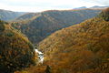
Breaks Canyon, May 2003
USA Kentucky location map.svg
Red pog.svg
Location on Kentucky/Virginia border
Usa edcp location map.svg
Red pog.svg
Breaks Interstate Park (the United States)
Location Kentucky and Virginia, United States
Nearest city Elkhorn City, Kentucky
Coordinates 37°17′47″N82°17′49″W / 37.29639°N 82.29694°W / 37.29639; -82.29694
Area4,500 acres (1,800 ha)
Established1954
Visitors286,401 [1] (in 2014)
Governing bodyBreaks Interstate Park Compact
www.breakspark.com

Breaks Interstate Park, also known as "the Breaks," is a bi-state state park located partly in southeastern Kentucky and southwestern Virginia in the Jefferson National Forest, at the northeastern terminus of Pine Mountain. The land is managed by an interstate compact between the states of Virginia [2] and Kentucky. [3] It is the only one of two interstate parks in the United States operated jointly under a compact rather than as two separate state park units.[ citation needed ] The Virginia Department of Conservation and Recreation and the Kentucky Department of Parks are still major partner organizations.[ clarification needed ]

Contents

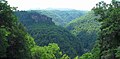
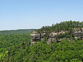
Breaks Interstate Park has been called the "Grand Canyon of the South". [4] Russell Fork river and Clinchfield Railroad (now the CSX Transportation Kingsport Subdivision) both pass through it. It is accessed via Virginia 80 and Kentucky 80 between Haysi, Virginia, and Elkhorn City, Kentucky, and passes through the community of Breaks, Virginia, east of the park.

History

This area was previously covered by a vast inland sea around 180 million years ago. [5] Over subsequent millennia, the Russel Fork gradually carved through the rock to form the spectacular valleys. Early human activity saw the area serve as hunting grounds for Shawnee and Cherokee people. In 1767, American frontiersman Daniel Boone passed through the area looking for an easier westward passage through Pine Mountain. [6] Boone subsequently gave the area its current name, The Breaks.

Preparations have been made to provide elk viewing areas. Elk were seen near the park in 2023 for the first time since the 1800s. [7]

Geography

Breaks Interstate Park is located about 5 miles (8 km) east of Elkhorn City, Kentucky. The park covers 4,500 acres (1,800 ha). The park's main feature, Breaks Canyon, is five miles long and ranges from 830 to 1,600 feet (250 to 490 m) deep. The canyon was formed by the Russell Fork river through millions of years of erosion. [8]

Climate

The climate in this area is characterized by hot, humid summers and generally mild to cool winters. According to the Köppen Climate Classification system, nearby Elkhorn City has a humid subtropical climate, abbreviated "Cfa" on climate maps. [9]

Climate data for Elkhorn City, Kentucky
MonthJanFebMarAprMayJunJulAugSepOctNovDecYear
Record high °F (°C)78
(26)
83
(28)
89
(32)
92
(33)
98
(37)
100
(38)
101
(38)
100
(38)
102
(39)
90
(32)
85
(29)
80
(27)
102
(39)
Mean daily maximum °F (°C)42
(6)
47
(8)
56
(13)
66
(19)
73
(23)
80
(27)
83
(28)
82
(28)
77
(25)
67
(19)
57
(14)
45
(7)
65
(18)
Mean daily minimum °F (°C)23
(−5)
26
(−3)
32
(0)
40
(4)
49
(9)
59
(15)
63
(17)
62
(17)
55
(13)
43
(6)
33
(1)
26
(−3)
43
(6)
Record low °F (°C)−14
(−26)
−12
(−24)
−3
(−19)
21
(−6)
25
(−4)
40
(4)
40
(4)
45
(7)
34
(1)
19
(−7)
9
(−13)
−11
(−24)
−14
(−26)
Average precipitation inches (mm)3.19
(81)
3.20
(81)
3.43
(87)
4.06
(103)
4.89
(124)
4.50
(114)
5.20
(132)
3.86
(98)
3.14
(80)
2.82
(72)
2.91
(74)
3.27
(83)
44.47
(1,129)
Source: The Weather Channel. [10]

Activities

The park provides hiking trails, as well as fishing, paddle boating, canoeing, and hydro biking on Laurel Lake, and white-water rafting on the Russell Fork. [11] Rock climbing with sandstone similar to the nearby New River Gorge. A lodge, cottages and a campground are available. [11] The park has a visitor center with exhibits on the area's historical and natural features, a conference center with restaurant, and an amphitheater. [12]

Related Research Articles

<span class="mw-page-title-main">Frankfort, Kentucky</span> Capital city of Kentucky, United States

Frankfort is the capital city of the U.S. state of Kentucky and the seat of Franklin County. It is a home rule-class city. The population was 28,602 at the 2020 United States census. Located along the Kentucky River, Frankfort is the principal city of the Frankfort, Kentucky Micropolitan Statistical Area, which includes all of Franklin and Anderson counties. It is the 4th least populous state capital in the United States, and the 13th most populous city in Kentucky.

<span class="mw-page-title-main">Watauga County, North Carolina</span> County in North Carolina, United States

Watauga County is a county located in the U.S. state of North Carolina. As of the 2020 census, the population was 54,086. Its county seat and largest community is Boone. The county is in an exceptionally mountainous region, known as the High Country. It is the home of Appalachian State University, which has approximately 20,023 students as of August 2020. Watauga County comprises the Boone, NC Micropolitan Statistical Area.

<span class="mw-page-title-main">Elkhorn City, Kentucky</span> City in Kentucky, United States

Elkhorn City is a home rule-class city in Pike County, Kentucky, in the United States. The population was 1,035 at the 2020 census. The city is located in proximity to the Breaks Interstate Park.

<span class="mw-page-title-main">Theodore Roosevelt National Park</span> National park in North Dakota, United States

Theodore Roosevelt National Park is an American national park of the badlands in western North Dakota comprising three geographically separated areas. Honoring U.S. President Theodore Roosevelt, it is the only American national park named directly after a single person.

<span class="mw-page-title-main">Kentucky Route 80</span> Highway in Kentucky, United States

Kentucky Route 80 (KY 80) is a 483.55-mile-long (778.20 km) state highway in the southern part of the U.S. state of Kentucky. The route originates on the state's western border at Columbus in Hickman County and stretches across the southern portion of the state, terminating southeast of Elkhorn City on the Virginia state line. It is the longest Kentucky State Highway, though the official distance as listed in route logs is much less due to multiple concurrencies with U.S. Route 68 (US 68) and US 23.

Kingdom Come State Park is a part of Kentucky's state park system in Harlan County atop Pine Mountain near the city of Cumberland. It was named after the 1903 best-selling novel The Little Shepherd of Kingdom Come by native Kentuckian John Fox, Jr. Features of the park include Raven Rock, Log Rock, and a 3.5-acre (1.4 ha) mountain lake. The section of the park is also a legally dedicated state nature preserve by the Office of Kentucky Nature Preserves.

<span class="mw-page-title-main">South Fork State Recreation Area</span> Recreation area in Nevada, United States

South Fork State Recreation Area is a state park unit of the state of Nevada covering nearly four thousand acres, located five miles (8.0 km) due south of Elko. The park comprises the 1,650-acre (670 ha) South Fork Reservoir and surrounding marsh, meadowlands, and hills.

<span class="mw-page-title-main">Appalachian mixed mesophytic forests</span> Temperate broadleaf and mixed forests ecoregion of the United States

The Appalachian mixed mesophytic forests is an ecoregion of the temperate broadleaf and mixed forests biome, as defined by the World Wildlife Fund. It consists of mesophytic plants west of the Appalachian Mountains in the Southeastern United States.

<span class="mw-page-title-main">Virginia State Route 80</span> State highway in western Virginia, US

State Route 80 is a primary state highway in the southwest part of the U.S. state of Virginia. It runs from the Kentucky state line at Breaks Interstate Park east to U.S. Route 11 near Meadowview. Kentucky Route 80 and Missouri's Route 80 continue the number west to Matthews, Missouri. The entire length of SR 80 is part of U.S. Bicycle Route 76.

<span class="mw-page-title-main">Corridor Q</span> Highway in the United States

Corridor Q is a highway in the U.S. states of Kentucky, Virginia, and West Virginia. It is part of the Appalachian Development Highway System and U.S. Route 460. Corridor Q runs from Corridor B near Pikeville, Kentucky, easterly to Interstate 81 in Christiansburg, Virginia.

The Kingsport Subdivision is a 133.2-mile railroad line owned and operated by CSX Transportation in the U.S. states of Kentucky, Virginia, and Tennessee. It was formerly part of the Huntington West Division. It became part of the CSX Florence Division on June 20, 2016. Running from Elkhorn City, Kentucky, south to Erwin, Tennessee, it forms the north half of the former Clinchfield Railroad; the south half, from Erwin to Spartanburg, South Carolina, is now the Blue Ridge Subdivision. From Elkhorn City, the line continues north as the Big Sandy Subdivision to Catlettsburg, Kentucky, on the Ohio River; trains can then continue to Ohio and other Midwest points. From Spartanburg, trains can continue to Georgia, Florida, or other Southeast states.

<span class="mw-page-title-main">Pine Mountain (Appalachian Mountains)</span> Ridge in the Appalachian Mountains running through Kentucky, Virginia and Tennessee

Pine Mountain is a ridge in the Appalachian Mountains running through Kentucky, Virginia and Tennessee. It extends about 125 miles from near Pioneer, Tennessee, to a location near Elkhorn City, Kentucky. Birch Knob, the highest point, is 3,273 feet (998 m) above sea level and is located on the Kentucky-Virginia border. It has long been a barrier to transportation, as the Cumberland River at Pineville, Kentucky is one of only two waterways that pass through the entire ridge. The other is the Clear Fork near Jellico, Tennessee.

<span class="mw-page-title-main">Geography of Kentucky</span> Overview of the Geography of Kentucky

Kentucky is situated in the Upland South region of the United States. A significant portion of eastern Kentucky is part of Appalachia.

<span class="mw-page-title-main">Big Run State Park</span> State park in Garrett County, Maryland

Big Run State Park is a public recreation area located at the northern end of the Savage River Reservoir, an impoundment of the Savage River, in Garrett County, Maryland. The state park occupies 300 acres (120 ha) in Savage River State Forest and encompasses the confluence of Monroe Run and Big Run. Park activities include boating, fishing, hiking, picknicking, and camping.

<span class="mw-page-title-main">Russell Fork</span> River in the United States

The Russell Fork is a 51.9-mile-long (83.5 km) tributary of the Levisa Fork in southwestern Virginia and southeastern Kentucky in the United States. Known for its whitewater, it rises in the Appalachian Mountains of southwest Virginia, in southern Buchanan County at the base of Big A Mountain, and flows northwest into Dickenson County. The Russell Fork continues to flow through the town of Haysi, Virginia, the Breaks Interstate Park, and the town of Elkhorn City, Kentucky, in Pike County, to the community of Millard, Kentucky where it flows into the Levisa Fork which, together with the Tug Fork, form the Big Sandy River.

<span class="mw-page-title-main">Dante, Virginia</span> Census-designated place in Virginia, United States

Dante is a census-designated place in Russell and Dickenson counties, Virginia, in the United States. The population as of the 2010 Census was 649.

<span class="mw-page-title-main">Rocky Fork Township, Boone County, Missouri</span> Township in Missouri, United States

Rocky Fork Township is one of ten townships in Boone County, Missouri, USA. The city of Hallsville is the largest settlement in the township.

<span class="mw-page-title-main">Little Laurel Branch</span> Protected natural area in Virginia, United States

Little Laurel Branch, a wildland in the George Washington and Jefferson National Forests of western Virginia, has been recognized by the Wilderness Society as a special place worthy of protection from logging and road construction. The Wilderness Society has designated the area as a "Mountain Treasure".

<span class="mw-page-title-main">Centennial Hills, Las Vegas</span> Neighborhood in Las Vegas, Nevada, U.S.

Centennial Hills is a neighborhood in northwest Las Vegas, Nevada, United States. It is bordered by the Snow Mountain Paiute Reservation and Tule Springs Fossil Beds National Monument to the north, Lower Kyle Canyon and the Red Rock Canyon National Conservation Area to the west, Summerlin to the south, and North Las Vegas to the east. The Spring Mountains are visible to the west with Gass Peak in the Las Vegas Range to the north. Lone Mountain lies within the neighborhood.

References

  1. Virginia State Parks 2014 Attendance and Economic Impact Archived April 2, 2015, at the Wayback Machine Virginia Department of Conservation and Recreation. Retrieved 2015-03-17.
  2. "Virginia State Park Locations". Virginia Department of Conservation and Recreation. 25 June 2013. Retrieved September 24, 2013.
  3. "About". Breaks Interstate Park. Kentucky Department of Parks. Retrieved September 24, 2013.
  4. "Breaks Interstate Park". Dickenson County Board of Supervisors. Retrieved February 5, 2024.
  5. "Our History | Breaks Park".
  6. "Our History". Breaks Interstate Park Commission. Retrieved September 24, 2013.
  7. Lee, Murry (2023-02-10). "Elk spotted in Breaks Interstate Park for first time in more than a century". WJHL | Tri-Cities News & Weather. Retrieved 2023-02-12.
  8. "Breaks Interstate Park". Virginia Tourism Corporation. June 27, 2012. Retrieved September 24, 2013.
  9. Climate Summary for Elkhorn City, Kentucky
  10. "Monthly Averages for Elkhorn City, KY". The Weather Channel . Retrieved May 23, 2014.
  11. 1 2 "Things to do". Breaks Interstate Park. Kentucky Department of Parks. Retrieved September 23, 2013.
  12. "Amphitheater Music Events". Breaks Interstate Park Commission. Retrieved September 24, 2013.