
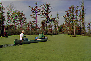
A swamp is a forested wetland. Swamps are considered to be transition zones because both land and water play a role in creating this environment. Swamps vary in size and are located all around the world. The water of a swamp may be fresh water, brackish water, or seawater. Freshwater swamps form along large rivers or lakes where they are critically dependent upon rainwater and seasonal flooding to maintain natural water level fluctuations. Saltwater swamps are found along tropical and subtropical coastlines. Some swamps have hammocks, or dry-land protrusions, covered by aquatic vegetation, or vegetation that tolerates periodic inundation or soil saturation. The two main types of swamp are "true" or swamp forests and "transitional" or shrub swamps. In the boreal regions of Canada, the word swamp is colloquially used for what is more formally termed a bog, fen, or muskeg. Some of the world's largest swamps are found along major rivers such as the Amazon, the Mississippi, and the Congo.
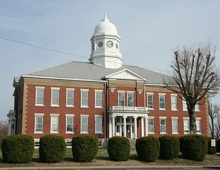
Ballard County is a county located in the west portion of the U.S. state of Kentucky. As of the 2020 census, the population was 7,728. Its county seat is Wickliffe and its largest city is LaCenter. The county was created by the Kentucky State Legislature in 1842 and is named for Captain Bland Ballard, a soldier, statesman, and member of the Kentucky General Assembly. Ballard County is part of the Paducah, KY-IL Metropolitan Statistical Area.

Big Lake National Wildlife Refuge is an 11,047-acre (45 km2) National Wildlife Refuge located in Mississippi County, Arkansas, managed by the United States Fish and Wildlife Service. It is situated 2 miles (3.2 km) east of Manila, Arkansas, and consists mostly of a shallow lake, swamp, and bottomland hardwood forests. The preservation of habitat for waterfowl in an intensely agricultural region is the primary purpose of the refuge. 6,400 acres (20 km2) of Big Lake is classified as a National Natural Landmark and 2,144 acres (8 km2) are classified as wilderness.
Corkscrew Swamp Sanctuary is a National Audubon Society sanctuary located in southwest Florida, north of Naples, Florida and east of Bonita Springs, in the United States. The sanctuary was established to protect one of the largest remaining stands of bald cypress and pond cypress in North America from extensive logging that was ongoing throughout the 1940s and 1950s.

The Great Dismal Swamp is a large swamp in the Coastal Plain Region of southeastern Virginia and northeastern North Carolina, between Norfolk, Virginia, and Elizabeth City, North Carolina. It is located in parts of the southern Virginia independent cities of Chesapeake and Suffolk and northern North Carolina counties of Gates, Pasquotank, and Camden. Some estimates place the original size of the swamp at over one million acres (4,000 km2). As of 2022 the size of the Great Dismal Swamp is around 750 square miles.

The Great Dismal Swamp National Wildlife Refuge was created in 1974 to help protect and preserve a portion of the Great Dismal Swamp, a marshy region on the Coastal Plain of southeastern Virginia and northeastern North Carolina between Norfolk, Virginia, and Elizabeth City, North Carolina in the United States. It is located in parts of the independent cities of Chesapeake and Suffolk in Virginia, and the counties of Camden, Gates, and Pasquotank in North Carolina.
The Cache River is a 92-mile-long (148 km) waterway in southernmost Illinois, in a region sometimes called Little Egypt. The basin spans 737 square miles (1,910 km2) and six counties: Alexander, Johnson, Massac, Pope, Pulaski, and Union. Located at the convergence of four major physiographic regions, the river is part of the largest complex of wetlands in Illinois. The Cache River Wetlands is America's northernmost cypress/tupelo swamp and harbors 91 percent of the state's high quality swamp and wetland communities. It provides habitat for more than 100 threatened and endangered species in Illinois. In 1996, the Cache was designated a Wetland of International Importance by the Ramsar Convention.

The Atchafalaya Basin, or Atchafalaya Swamp, is the largest wetland and swamp in the United States. Located in south central Louisiana, it is a combination of wetlands and river delta area where the Atchafalaya River and the Gulf of Mexico converge. The river stretches from near Simmesport in the north through parts of eight parishes to the Morgan City southern area.

The Mingo National Wildlife Refuge is a 21,676-acre (87.7-km2) National Wildlife Refuge located in northwestern Stoddard and southeastern Wayne counties in Missouri. Its southwesternmost portion lies on the shores of Lake Wappapello. Named after the Mingo tribe, it was established to preserve bottomland hardwoods and provide waterfowl and other migratory birds in the Mississippi Flyway with nesting, feeding, brooding, and resting habitat.

The Francis Beidler Forest is an Audubon wildlife sanctuary in Four Holes Swamp, a blackwater creek system in South Carolina, United States. It consists of over 18,000 acres (73 km²) of mainly bald cypress and tupelo gum hardwood forest and swamp with approximately 1,800 acres (7 km2) of old-growth forest. It is the largest virgin stand of cypress-tupelo forest in the world, with some Bald Cypress trees over 1,000 years old. It is a favorite haunt of birdwatchers and is used for biological research projects by area schools.

The Blackwater River of southeastern Virginia flows from its source near the city of Petersburg, Virginia for about 105 miles (170 km) through the Inner Coastal Plain region of Virginia. The Blackwater joins the Nottoway River to form the Chowan River, which empties into Albemarle Sound. The Blackwater-Nottoway confluence forms the boundary between Virginia and North Carolina.
The Office of Kentucky Nature Preserves is an agency of the Commonwealth of Kentucky in the United States dedicated to the protection of Kentucky's natural heritage. The agency's primary focus is protecting rare and endangered species habitat. It oversees a statewide program of nature preserves, the Kentucky Wild Rivers Program, and the "Nature's Finest" license plate program of the Kentucky Heritage Land Conservation Fund Board. The program was formerly known as the "Kentucky State Nature Preserves Commission", from 1976 until a reorganization in 2018.

Battle Creek Cypress Swamp (BCCS) is a forested wetland near Prince Frederick in Calvert County, Maryland, United States. It is one of the northernmost sites of naturally occurring bald cypress trees in North America, and the only large stand of the trees on the western shore of Maryland. In 1965, the National Park Service designated the BCCS a National Natural Landmark.

Dendron Swamp Natural Area Preserve is a 636-acre (257 ha) Natural Area Preserve in Sussex County, Virginia, USA. Located along the Blackwater River, the preserve supports a bald cypress and tupelo swamp. Canopy trees over 98 feet (30 m) tall line the river for two miles (3.2 km) and the swamp shows only occasional signs of logging. Some of the larger cypresses are believed to be over 600 years old. Within the preserve is a nesting site for the great blue heron.
The Atchafalaya National Wildlife Refuge is located about 30 miles (48 km) west of Baton Rouge, Louisiana, and one mile (1.6 km) east of Krotz Springs, Louisiana, lies just east of the Atchafalaya River. In 1988 under the administration of Governor Foster the "Atchafalaya Basin Master Plan" was implemented that combined the 11,780-acre (4,770 ha) Sherburne Wildlife Management Area (WMA), the 15,220-acre (6,160 ha) Atchafalaya National Wildlife Refuge, and the 17,000-acre (6,900 ha) U.S. Army Corps of Engineers' Bayou Des Ourses into the Sherburne Complex Wildlife Management Area.
Lake Ophelia National Wildlife Refuge was established in 1988 to protect the Mississippi/Red River floodplain ecosystem. The refuge is located in Avoyelles Parish, Louisiana, east central Louisiana. The refuge is named for its most prominent water body, the 350-acre (1.4 km2) Lake Ophelia that was at one time a channel of the nearby Red River of the South.

Heron Pond – Little Black Slough Nature Preserve is a parcel of protected wetland property located in Belknap, Illinois, approximately 5 miles (8 km) southwest of Vienna, in Johnson County. It was designated a National Natural Landmark in 1972. As part of the Cache River basin, it is classified as a wetland of international importance under the Ramsar Convention.

Horseshoe Lake is a 2,007 acres (812 ha) natural oxbow lake in Alexander County, Illinois. It is the site of Illinois's Horseshoe Lake State Fish and Wildlife Area, a state park 10,645 acres (43 km2) in size. It has a 20 miles (32 km) shoreline and a depth of 4 ft (1.2 m), with a maximum depth of 5–6 feet (1.5–1.8 m). A remnant of a large meander of the Mississippi River, it is today a shallow, isolated patch of water located near Cairo and the southern tip of Illinois. In 1972, the Horseshoe Lake Nature Preserve was designated as a National Natural Landmark by the National Park Service.
Murphy's Pond is a wetlands complex located in Hickman County, Kentucky. While only about 175 acres in size, the pond is notable for being one of the largest bald cypress swamps remaining in Kentucky and for its high cottonmouth snake population density.
