John James Audubon State Park

Last updated

John James Audubon State Park
Audubonwildernesslake.JPG
Wilderness Lake at Audubon State Park.
USA Kentucky location map.svg
Red pog.svg
Usa edcp location map.svg
Red pog.svg
Location US 41, Henderson, Kentucky
Coordinates 37°52′56″N87°32′53″W / 37.88222°N 87.54806°W / 37.88222; -87.54806
Areaabout 575 acres (2.33 km2)
Built1934
ArchitectDonald Corley; Bernard Alves
Architectural styleLate 19th and 20th Century Revivals, Norman Revival
NRHP reference No. 87002220 [1]
Added to NRHPMarch 10, 1988

John James Audubon State Park is located on U. S. Route 41 in Henderson, Kentucky, just south of the Ohio River. Its inspiration is John James Audubon, the ornithologist, naturalist, and painter who resided in Henderson from 1810 to 1819 when Henderson was a frontier village. [2]

Contents

The park was listed on the National Register of Historic Places in 1988. [1] [3] Most of the park has been dedicated as a state nature preserve by the Office of Kentucky Nature Preserves, which also added a 650-acre addition in 2016 through its Kentucky Heritage Land Conservation Fund program.

This is 1 of 3 state parks in Kentucky that will be in the path of totality for the 2024 total solar eclipse. [4]

History

John James Audubon operated small businesses in Henderson, Kentucky with mixed success. Nine enslaved people worked for the Audubon family at the time, until he needed money, then he sold them. [5] His passion for exploring the forests of the region and sketching and painting wildlife while in Henderson, particularly birds, has been well documented.[ citation needed ]

In 1934, the Wolf Hills area in Henderson was selected for a new state park (meeting the minimum 300 acres needed for park development). Susan Towles, a Henderson librarian, supplied the necessary research and documentation to establish a historic connection to the land and Audubon.[ citation needed ]

In September 1934, a Civilian Conservation Corps (CCC) base Camp Cromwell (named in honor of the Director of the Kentucky State Parks, Emma Guy Cromwell) was established off US 41 near John James Audubon State Park. After the 300-acres was procured for park development, approximately 200 CCC, Company 1540 employees were dispatched from their West Virginia base to Henderson where they were joined by others including several Henderson natives. Over the next four years the CCC drained swamps, build two lakes and developed trails and roads. With the help of the Works Progress Administration (WPA), the park shelters, the Tea House (presently the park office), and the Audubon Museum were constructed from local stone and mill work. The entire project cost approximately $500,000.[ citation needed ]

Progress on the park was not always smooth. There were long delays caused by lack of funds and disagreements over the park's focus. Henderson attorney and businessman Gibney Oscar Letcher helped guide the project along; working among the CCC, WPA, National Park Service, Kentucky Department of Parks, local contractors and suppliers, the Audubon Park Committee and the Audubon family descendants.[ citation needed ]

The Wilderness Lake was completed in the spring of 1938 but the work continued slowly on the Tea House and gardens, the recreational lake, the roads and the cottages. The Tea House was completed in June 1940 and served three meals daily until December 1941. In the spring of 1941, the cottages were completed and the recreational lake was excavated and filled. That completed the work under the federal New Deal programs.[ citation needed ]

After the attack on Pearl Harbor, December 7, 1941, Kentucky and the nation prepared for war. Camp Cromwell was converted into a Naval Cadet Aviation Training School during the war and supervised by Evansville College (presently the University of Evansville).[ citation needed ]

After WWII, attention returned to John James Audubon State Park. Beginning in 1948 and lasting until 1955, a program of restoration and construction was carried out. Some of the projects completed were new museum lighting installation; picnic area, bathhouse and beach, landscaping, parking, lake dam and shelter construction. From 1960 to 1969 another $500,000 was invested in the park with construction of a camping area and nine-hole golf course. Additional land was acquired bringing the park to nearly 700 acres. New picnic shelters and employee housing were also constructed.[ citation needed ]

The park was listed on the National Register of Historic Places in 1988.[ citation needed ]

In 1990 the state General Assembly allocated $2.5 million for a thorough renovation of the museum and the additional 9,500-square-foot (880 m2) nature center to promote the study of nature. In the spring of 1992, the largest renovation in the museum's 54-year history began and in December 1993 the refurbished and expanded museum reopened.[ citation needed ]

Audubon Museum

The museum design is French heritage. The style also permitted the inclusion of small niches in the museum tower for nesting birds.

Alice Tyler, widow of J. J. Audubon's great-grandson, Leonard Sanford Tyler, had been in contact with Susan Towles during the park's development. It was her wish that the large personal collection of Audubon material in her possession be placed on loan in the new Audubon Museum. Mrs. Tyler shipped her collection to Henderson in the spring of 1938 and the museum opened July 16, 1938.

The Tyler collection was later purchased in 1994 through numerous donations made to the Friends of Audubon, as well as contributions from the Preston Foundation and the Kentucky State Parks.

Today, the museum proudly displays one of the world's largest collections of original Audubon art that made the wildlife artist a legend. But it is the personal artifacts and memorabilia that portray the often difficult life of Audubon - more starving artist than artistic success. The museum's four exhibit halls chronicle Audubon's life, including his 1810–1819 residence in Henderson, Kentucky. Highlights of the collection include the American Bald Eagle oil, a four-volume edition of the Birds of America, a personal seal, handwritten journals, the silver service Audubon sent from England to his devoted wife, Lucy (replacing the service set that was lost during bankruptcy).

Description

Audubon Park consists of approximately 700 acres (2.8 km2), primarily hilly forests that include 338-acre (1.4 km2) dedicated by the Office of Kentucky Nature Preserves with old-growth trees and trails.

Highlights include the internationally acclaimed Audubon Museum that features numerous valuable examples of Audubon art as well as a gift shop and nature center; a nine-hole golf course; six cottages; a 69-acre (280,000 m2) campground that accommodates tents and campers; a 28-acre (110,000 m2) manmade fishing lake with rental pedal boats; 6.5 miles (10.5 km) of forest hiking trails; tennis courts; four picnic shelters; and playground.

A variety of year-round, interpretive programs are conducted under the direction of a full-time naturalist and museum educator. Programs focus on art history, as well as native plants, animals, conservation and recycling.

Audubon Park receives local support from a not-for-profit organization, the Friends of Audubon.

Related Research Articles

<span class="mw-page-title-main">Robbers Cave State Park</span> State park in Oklahoma, United States

Robbers Cave State Park is a state park in Latimer County, Oklahoma. It is located 5 miles (8.0 km) north of Wilburton, Oklahoma, on Oklahoma State Highway 2. Originally named Latimer State Park, it received its current name in 1936. It is located in the scenic, hilly woodlands of the Sans Bois Mountains of southeast Oklahoma. This park is a favorite of rappellers, equestrians, hikers and outdoor lovers. The park and adjoining wildlife management area covers more than 8,000 acres (3,200 ha) and includes three lakes. It offers visitors acres of discovery and enjoyment including trout fishing in season, boating, hunting, mountain biking, trails for hikers and horses, sandstone cliffs for climbing and rappelling, and fall foliage viewing. In addition, Robbers Cave is historically notable as a former hideout for infamous outlaws Belle Starr and Jesse James.

<span class="mw-page-title-main">F. D. Roosevelt State Park</span> United States historic place

F.D. Roosevelt State Park is a 9,049 acres (36.62 km2) Georgia state park located near Pine Mountain and Warm Springs. The park is named for former U.S. President Franklin Delano Roosevelt, who sought a treatment for his paralytic illness in nearby Warm Springs at the Little White House. The park is located along the Pine Mountain Range. The western portion of the park, formerly named Pine Mountain State Park, was named a National Historic Landmark in 1997. F.D. Roosevelt State Park is Georgia's largest state park.

<span class="mw-page-title-main">Maquoketa Caves State Park</span>

Maquoketa Caves State Park is a state park of Iowa, United States, located in Jackson County. It stands northwest of the city of Maquoketa. In 1991 111 acres (45 ha) on the east side of the park were listed as a historic district on the National Register of Historic Places.

<span class="mw-page-title-main">Pokagon State Park</span> State park in Indiana, United States

Pokagon State Park is an Indiana state park in the northeastern part of the state, near the village of Fremont and 5 miles (8 km) north of Angola. It was named for the 19th-century Potawatomi chief, Leopold Pokagon, and his widely known son, Simon Pokagon, at Richard Lieber's suggestion. The 1,260-acre (5.1 km2) park has an inn, camping facilities, and a staff of full-time naturalists. Pokagon receives nearly 640,000 visitors annually.
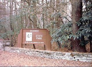
<span class="mw-page-title-main">Legion State Park</span> State park in Mississippi, United States

Legion State Park is public recreation area located on the north edge of the city of Louisville, Mississippi, and adjacent to Tombigbee National Forest. As Legion State Park Historic District, the state park entered the National Register of Historic Places in 1998. It is managed by the Mississippi Department of Wildlife, Fisheries and Parks.

<span class="mw-page-title-main">Wall Doxey State Park</span> State park in Mississippi, United States

Wall Doxey State Park is a public recreation area located off Mississippi Highway 7, seven miles (11 km) south of Holly Springs, Mississippi. The state park is centered on 60-acre (24 ha) Spring Lake.

<span class="mw-page-title-main">Bewabic State Park</span> Park in Michigan, USA

Bewabic State Park is a public recreation area covering 315 acres (127 ha) on the shore of Fortune Lake, four miles (6.4 km) west of Crystal Falls in Iron County, Michigan. The state park's rich Civilian Conservation Corps history is evidenced by the CCC structures still in use. The park was listed on the National Register of Historic Places for its CCC-related architecture in 2016.

<span class="mw-page-title-main">Wells State Park (Michigan)</span> Park in Michigan, USA

J.W. Wells State Park is a state park in the U.S. state of Michigan. The 678-acre (2.74 km2) park is located in Menominee County on the shore of Lake Michigan's Green Bay, just south of Cedar River. It is on M-35, roughly midway between Menominee and Escanaba. It was added to the National Register of Historic Places in 2002.

<span class="mw-page-title-main">Watoga State Park</span> State park in Pocahontas County, West Virginia, USA

Watoga State Park is a state park located near Seebert in Pocahontas County, West Virginia. The largest of West Virginia's state parks, it covers slightly over 10,100 acres (41 km2). Nearby parks include the Greenbrier River Trail, which is adjacent to the park, Beartown State Park, and Droop Mountain Battlefield State Park. Also immediately adjacent to the park is the 9,482-acre Calvin Price State Forest. It is one of the darkest night skies of all of West Virginia State Parks.

<span class="mw-page-title-main">Blackacre Nature Preserve and Historic Homestead</span> United States historic place

Blackacre State Nature Preserve is a 271-acre (110 ha) nature preserve and historic homestead in Louisville, Kentucky. The preserve features rolling fields, streams, forests, and a homestead dating back to the 18th century. For visitors, the preserve features several farm animals including horses, goats, and cows, hiking trails, and a visitor's center in the 1844-built Presley Tyler home. Since 1981, it has been used by the Jefferson County Public Schools as the site of a continuing environmental education program. About 10,000 students visit the outdoor classroom each year.

The Office of Kentucky Nature Preserves is an agency of the Commonwealth of Kentucky in the United States dedicated to the protection of Kentucky's natural heritage. The agency's primary focus is protecting rare and endangered species habitat. It oversees a statewide program of nature preserves, the Kentucky Wild Rivers Program, and the "Nature's Finest" license plate program of the Kentucky Heritage Land Conservation Fund Board. The program was formerly known as the "Kentucky State Nature Preserves Commission", from 1976 until a reorganization in 2018.

<span class="mw-page-title-main">Backbone State Park</span> State park in Iowa

Backbone State Park is Iowa's oldest state park, dedicated in 1919. Located in the valley of the Maquoketa River, it is approximately three miles (5 km) south of Strawberry Point in Delaware County. It is named for a narrow and steep ridge of bedrock carved by a loop of the Maquoketa River originally known as the Devil's Backbone. The initial 1,200 acres (490 ha) were donated by E.M. Carr of Lamont, Iowa. Backbone Lake Dam, a relatively low dam built by the Civilian Conservation Corps (CCC) in the 1930s, created Backbone Lake. The CCC constructed a majority of trails and buildings which make up the park.

<span class="mw-page-title-main">Crystal Lake State Park</span> State park in Orleans County, Vermont

Crystal Lake State Park is a day-use state park and historic site in Barton, Vermont, United States. It is located at 96 Bellwater Avenue, off Willoughby Lake Road just east of the village, at the northwestern end of 763-acre (309 ha) Crystal Lake. It features a sandy beach with swimming area, and a bath house built by the Civilian Conservation Corps (CCC). A cottage is available for rental. The park was added to the U.S. National Register of Historic Places on August 30, 2005, for its association with the CCC.

<span class="mw-page-title-main">Black Hawk State Park</span> State park in Sac County, Iowa

Black Hawk State Park is a state park of Iowa, USA, in the town of Lake View. The park includes land, campgrounds, trails, game preserves, historic structures, and the waters of Black Hawk Lake. Also it is home to the Lake View Water Carnival. This event is held the third full weekend in July every year, and includes many family-friendly activities including a Water Parade. Three sections of the park were listed on the National Register of Historic Places in 1991.

<span class="mw-page-title-main">Staunton River State Park</span> State park in Virginia, USA

Staunton River State Park is a state park in Virginia. One of the Commonwealth's original state parks, built by the Civilian Conservation Corps and opening in 1936, it is located along the Staunton River near Scottsburg, Virginia. It is an International Dark Sky Park.

<span class="mw-page-title-main">Lacey-Keosauqua State Park</span> State park in Iowa

Lacey-Keosauqua State Park is located southwest of Keosauqua, Iowa, United States. The park is located along the Des Moines River in Van Buren County. First dedicated in 1921, it is the largest state park in size in Iowa. In 1990, three areas were named nationally recognized historic districts and listed on the National Register of Historic Places.

<span class="mw-page-title-main">Stillwater State Park</span> State park in Caledonia County, Vermont

Stillwater State Park is a state park located on Lake Groton in Groton, Vermont. The park is located in Groton State Forest close to the Groton Nature Center, Boulder Beach State Park and Big Deer State Park. The park offers camping, picnicking, and access to water-related activities on Lake Groton. The park was developed in the 1930s by crews of the Civilian Conservation Corps (CCC). It is open to the public between Memorial Day weekend and Columbus Day weekend; fees are charged for day use and camping.

<span class="mw-page-title-main">Underhill State Park</span> State park in Chittenden County, Vermont

Underhill State Park is a state park in Underhill, Vermont. It is situated on the west slope of 4,300 feet Mount Mansfield, in the 39,837-acre Mount Mansfield State Forest. Activities includes hiking, camping, mountain biking, stream fishing, wildlife watching, and picnicking. Facilities include group and individual camping areas, a picnic shelter, and hiking trails. The park is formally open between Memorial Day weekend and Columbus Day weekend, but is accessible for periods outside those times; fees are charged. Much of the park's infrastructure was built by the Civilian Conservation Corps (CCC) in the 1930s; these facilities were listed on the National Register of Historic Places in 2002.

<span class="mw-page-title-main">Maidstone State Park</span> State park in Essex County, Vermont

Maidstone State Park is a state park in the U.S. state of Vermont. The park is located in the town of Maidstone in Essex County in Vermont's Northeast Kingdom. One of the state's most remote parks, it provides public access to the 796-acre (322 ha) glacial Maidstone Lake in Maidstone State Forest. The park was developed by the Civilian Conservation Corps and opened in 1938. Activities include fishing, hiking, camping, boating, wildlife watching, and picnicking. The park is open from Memorial Day weekend to Columbus Day weekend; fees are charged for day use and camping.

References

  1. 1 2 "National Register Information System". National Register of Historic Places . National Park Service. March 13, 2009.
  2. "John James Audubon: A complicated history". Audubon – History. Retrieved July 28, 2022.
  3. Robert M. Polsgrove (September 4, 1987). "National Register of Historic Places Registration: John James Audubon State Park". National Park Service . Retrieved February 26, 2018. With 19 photos from 1987.
  4. R, Mike (July 22, 2021). "Kentucky 2024 Eclipse State Park". CosmosPNW. Retrieved October 3, 2022.
  5. "The largest Audubon group yet is changing its name, rebuking an enslaver", published July 28, 2022 in The Washington Post , accessed August 17, 2022