Related Research Articles

A flyway is a flight path used by large numbers of birds while migrating between their breeding grounds and their overwintering quarters. Flyways generally span continents and often pass over oceans. Although applying to any species of migrating bird, the concept was first conceived and applied to waterfowl and shore birds. The flyways can be thought of as wide arterial highways to which the migratory routes of different species are tributaries. An alternative definition is that a flyway is the entire range of a migratory bird, encompassing both its breeding and non-breeding grounds, and the resting and feeding locations it uses while migrating. There are four major north–south flyways in North America and six covering Eurasia, Africa, and Australasia.
The Canadian Wildlife Service or CWS, is a Branch of the Department of the Environment, a department of the Government of Canada. November 1, 2012 marked the 65th anniversary of the founding of Service.

Ducks Unlimited (DU) is an American nonprofit organization 501(c) dedicated to the conservation of wetlands and associated upland habitats for waterfowl, other wildlife, and people. It has had a membership of around 700,000 since January 2013.

Waterfowl hunting is the practice of hunting ducks, geese, or other waterfowl for food and sport.

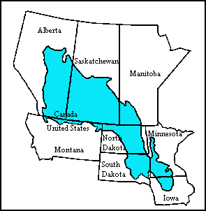
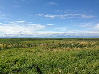
The Prairie Pothole Region is an expansive area of the northern Great Plains that contains thousands of shallow wetlands known as potholes. These potholes are the result of glacier activity in the Wisconsin glaciation, which ended about 10,000 years ago. The decaying ice sheet left behind depressions formed by the uneven deposition of till in ground moraines. These depressions are called potholes, glacial potholes, kettles, or kettle lakes. They fill with water in the spring, creating wetlands, which range in duration from temporary to semi-permanent. The region covers an area of about 800,000 sq. km and expands across three Canadian provinces and five U.S. states. The hydrology of the wetlands is variable, which results in long term productivity and biodiversity. The PPR is a prime spot during breeding and nesting season for millions of migrating waterfowl.

The Alaksen National Wildlife Area is located on Westham Island in the city of Delta, British Columbia. It is an important stopover point for many species of birds migrating along the Pacific Flyway.
The Eastern Habitat Joint Venture is a partnership established on 15 November 1989 between governments, organizations, and conservation groups in eastern Canada to protect and enhance wetlands important to migratory birds, under the auspices of the North American Waterfowl Management Plan.
The Prairie Habitat Joint Venture is a partnership between governments, organizations, and conservation groups in the provinces of Manitoba, Saskatchewan, and Alberta in Canada. It is one of four Canadian habitat joint ventures operating as part of the North American Waterfowl Management Plan, and is contiguous with the Prairie Pothole Joint Venture in the United States.

The Central Asian Flyway (CAF), Central Asian-Indian Flyway, or Central Asian-South Asian Flyway is a flyway covering a large continental area of Eurasia between the Arctic Ocean and the Indian Ocean and the associated island chains. The CAF comprises several important migration routes of waterbirds, most of which extend from the northernmost breeding grounds in Siberia to the southernmost non-breeding wintering grounds in West Asia, India, the Maldives and the British Indian Ocean Territory.
The North American Wetlands Conservation Act authorizes a wetlands habitat program, administered by the United States Fish and Wildlife Service, which provides grants to protect and manage wetland habitats for migratory birds and other wetland wildlife in the United States, Mexico, and Canada. A nine-member council meets periodically to decide which projects to fund.

Hagerman National Wildlife Refuge (HNWR), a haven for migratory birds and other wildlife, lies in northwestern Grayson County, Texas, on the Big Mineral Arm of Lake Texoma, on the Red River between Oklahoma and Texas. This National Wildlife Refuge is made up of water, marsh, and upland habitat. Visitors can hike, observe wildlife, hunt, and fish throughout the year.
Pass a Loutre Wildlife Management Area (WMA) is a 66,000-acre (270 km2) protected wetland in Plaquemines Parish, Louisiana, United States. The WMA is located due south and bordering the 48,000 acre Delta National Wildlife Refuge, accessible only by air or boat, contains the Pass A L'Outre Lighthouse, and Port Eads is within the boundary.
The Louisiana Department of Wildlife and Fisheries (LDWF) is a state agency of Louisiana that maintains state wildlife and fishery areas. The agency is headquartered in the capital city of Baton Rouge.
The Canadian Intermountain Joint Venture (CIJV) is a partnership of "government agencies, Aboriginal groups, nongovernmental organizations, industry, universities and landowners" for the implementation of the North American Waterfowl Management Plan in the inter-mountain areas of south and central British Columbia in Canada, and the south-western mountain region of Alberta. Its region of operation includes "all the mountain national parks", with boundaries delineated by the border with the United States to the south, the eastern crest of the Rocky Mountains to the east, the crest of the Coast Mountains to the west, and the boreal forest to the north. It is adjacent to the Intermountain West Joint Venture to the south, the Pacific Coast Joint Venture to the west, and the Prairie Habitat Joint Venture to the east.
The Pacific Birds Habitat Joint Venture (PBHJV), previously Pacific Coast Joint Venture is a partnership established in 1991 between governments, organizations, and conservation groups along the Pacific Coast of the United States and Canada, established to protect and enhance wetlands important to migratory birds, within the framework of the North American Waterfowl Management Plan (NAWMP). Participants include the provincial government of British Columbia in Canada, and the state governments of Alaska, California, Hawaii, Oregon and Washington in the United States. The venture's scope covers an area from San Francisco Bay to Alaska, west of the Coast Mountains, and it was the first joint venture of the NAWMP to have an international scope.
The Arctic Goose Joint Venture (AGJV) is a conservation partnership established in 1989 between governments, organizations, and conservation groups to coordinate research and monitoring of Arctic, sub-Arctic and boreal nesting goose populations of North America, specifically the cackling goose, Canada goose, emperor goose, greater white-fronted goose, Ross's goose, and snow goose. Executing Arctic research expeditions in collaboration with partners is a primary goal of the venture, so that the logistics of such research can be coordinated efficiently. One of its main activities is to collar geese in Canada, the United States, and other nearby Arctic areas, such as Wrangel Island of Russia.
The Intermountain West Joint Venture (IWJV) is a partnership of government agencies, nongovernmental organizations, and other public and private landowners for the conservation of bird habitats in the inter-mountain areas of the western United States. It was established in 1994 and focuses on the "implementation of the conservation goals and objectives of five major bird initiatives": North American Waterfowl Management Plan, Partners in Flight, United States Shorebird Conservation Plan, North American Waterbird Conservation Plan and the National Sage Grouse Conservation Planning Framework. Its primary objective is to address conservation issues for about 40 waterbird species which use the marshes, playas, riparian zones, lakes and other wetlands throughout its extent.
The Sea Duck Joint Venture (SDJV) is a conservation partnership established in 1998 whose mission is "promoting the conservation of North America’s Sea Ducks". The partners are the Canadian Wildlife Service, the United States Fish and Wildlife Service, the United States Geological Survey, Ducks Unlimited, Bird Studies Canada, the Pacific Flyway Council, and the council for U.S. Flyways. It is one of three species joint ventures operating within the North American Waterfowl Management Plan.

The Black Duck Joint Venture is a conservation partnership established in 1989 to stabilize and restore the population of the American black duck. It consists of government and non-governmental agencies and organizations in Canada and the United States. Its geographical scope is the Canadian provinces of Ontario, Quebec, New Brunswick, Nova Scotia, Prince Edward Island, and Newfoundland and Labrador, and the 23 U.S. states in the Atlantic and Mississippi Flyways. It was the first of the three species joint ventures operating within the North American Waterfowl Management Plan to be established.

The Central Asian-Indian Flyway(CAIF), or Central Asian-South Asian Flyway is a flyway covering a large continental area of Eurasia between the Arctic Ocean and the Indian Ocean and the associated island chains. The CAIF comprises several important migration routes of waterbirds, most of which extend from the northernmost breeding grounds in Siberia to the southernmost non-breeding wintering grounds in West Asia, India, the Maldives and the British Indian Ocean Territory.
References
- ↑ "What is NAWMP?". Environment Canada, Canadian Wildlife Service (NABCI/NAWMP Coordination Office). Retrieved 2008-06-08.
- 1 2 3 4 5 "North American Waterfowl Management Plan". United States Fish and Wildlife Service, Division of Bird Habitat Conservation. Retrieved 2008-06-08.
- ↑ "North American Waterfowl Management Plan: Status Report 1997-1998". Environment Canada. Archived from the original on 2008-05-29. Retrieved 2008-06-08.
- ↑ "Eastern Habitat Joint Venture (EHJV)". Environment Canada. Archived from the original on November 17, 2007. Retrieved 2008-06-08.
- 1 2 "North American Waterfowl Management Plan: Restoring Waterfowl Populations". Saskatchewan Watershed Authority. Retrieved 2008-06-08.
- ↑ Only four such ventures are in the scope of the North American Waterfowl Management Plan (see the Canada section of "Habitat joint ventures"); the others operate in conjunction with it.
- ↑ "Partners/Joint Ventures". Environment Canada, Canadian Wildlife Service (NABCI/NAWMP Coordination Office). Retrieved 2008-06-08.
- ↑ "Joint Ventures Directory". United States Fish and Wildlife Service. Retrieved 2008-06-09.
- ↑ Allred, Karla (October 1996). "Endangered Species and North American Waterfowl Management Plan Joint Venture Areas" (PDF). U.S Army Corps of Engineers, Water Resources Support Center. p. 27. Archived from the original (PDF) on 2013-04-08. Retrieved 2008-06-08.
- ↑ "North American Waterfowl Management Plan 2002 Update". Indiana Department of Natural Resources. Retrieved 2008-06-08.