Related Research Articles

The Canadian Prairies is a region in Western Canada. It includes the Canadian portion of the Great Plains and the Prairie provinces, namely Alberta, Saskatchewan, and Manitoba. These provinces are partially covered by grasslands, plains, and lowlands, mostly in the southern regions. The northernmost reaches of the Canadian Prairies are less dense in population, marked by forests and more variable topography. If the region is defined to include areas only covered by prairie land, the corresponding region is known as the Interior Plains. Physical or ecological aspects of the Canadian Prairies extend to northeastern British Columbia, but that area is not included in political use of the term.

The Canadian Wildlife Service or CWS, is a Branch of the Department of Environment and Climate Change Canada, a department of the Government of Canada. November 1, 2012 marked the 65th anniversary of the founding of Service.

Aspen parkland refers to a very large area of transitional biome between prairie and boreal forest in two sections, namely the Peace River Country of northwestern Alberta crossing the border into British Columbia, and a much larger area stretching from central Alberta, all across central Saskatchewan to south central Manitoba and continuing into small parts of the US states of Minnesota and North Dakota. Aspen parkland consists of groves of aspen, poplar and spruce, interspersed with areas of prairie grasslands, also intersected by large stream and river valleys lined with aspen-spruce forests and dense shrubbery. This is the largest boreal-grassland transition zone in the world and is a zone of constant competition and tension as prairie and woodlands struggle to overtake each other within the parkland.

The Boreal Shield Ecozone, as defined by the Commission for Environmental Cooperation (CEC), is the largest ecozone in Canada. Covering 1.8 million square kilometres it covers almost 20% of Canada's landmass, stretching from northern Saskatchewan to Newfoundland.
Ducks Unlimited (DU) is an American 501(c)(3) nonprofit organization dedicated to the conservation of wetlands and associated upland habitats for waterfowl, other wildlife, and people. It has had a membership of around 700,000 since January 2013.
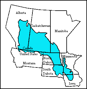
The Prairie Pothole Region is an expansive area of the northern Great Plains that contains thousands of shallow wetlands known as potholes. These potholes are the result of glacier activity in the Wisconsin glaciation, which ended about 10,000 years ago. The decaying ice sheet left behind depressions formed by the uneven deposition of till in ground moraines. These depressions are called potholes, glacial potholes, kettles, or kettle lakes. They fill with water in the spring, creating wetlands, which range in duration from temporary to semi-permanent. The region covers an area of about 800,000 sq. km and expands across three Canadian provinces and five U.S. states. The hydrology of the wetlands is variable, which results in long term productivity and biodiversity. The PPR is a prime spot during breeding and nesting season for millions of migrating waterfowl.

The geography of Saskatchewan is unique among the provinces and territories of Canada in some respects. It is one of only two landlocked regions and it is the only region whose borders are not based on natural features like lakes, rivers, or drainage divides. The borders of Saskatchewan, which make it very nearly a trapezoid, were determined in 1905 when it became a Canadian province. Saskatchewan has a total area of 651,036 square kilometres (251,366 sq mi) of which 591,670 km2 (228,450 sq mi) is land and 59,366 km2 (22,921 sq mi) is water.

Oak Hammock Marsh is a marsh and a wildlife management area located 34 kilometres (21 mi) north of Winnipeg, Manitoba, Canada. The WMA is considered to be a Class IV protected area under the IUCN protected area management categories. The marsh is recognized as an Important Bird Area (IBA) for its globally significant numbers of waterfowl and shorebirds. It is a designated Ramsar site due to its international importance as a breeding and staging area for waterfowl and other migratory birds. It is 3,578.47 hectares in size.

The Boreal Plains Ecozone, as defined by the Commission for Environmental Cooperation (CEC), is a terrestrial ecozone in the western Canadian provinces of Manitoba, Saskatchewan and Alberta. It also has minor extensions into northeastern British Columbia and south-central Northwest Territories. The region extends over 779,471 km2, of which 58,981 km2 is conserved.
The North American Waterfowl Management Plan (NAWMP) is an international plan to conserve waterfowl and migratory birds in North America. It was established in 1986 by Canada and the United States, and expanded to include Mexico in 1994.
The Eastern Habitat Joint Venture is a partnership established on 15 November 1989 between governments, organizations, and conservation groups in eastern Canada to protect and enhance wetlands important to migratory birds, under the auspices of the North American Waterfowl Management Plan.
The economy of Saskatchewan has been associated with agriculture resulting in the moniker "Bread Basket of Canada" and Bread Basket of the World. According to the Government of Saskatchewan, approximately 95% of all items produced in Saskatchewan, depend on the basic resources available within the province. Various grains, livestock, oil and gas, potash, uranium, wood and their spin off industries fuel the economy.

The native flora of Saskatchewan includes vascular plants, plus additional species of other plants and plant-like organisms such as algae, lichens and other fungi, and mosses. Non-native species of plants are recorded as established outside of cultivation in Saskatchewan, of these some non-native species remain beneficial for gardening, and agriculture, where others have become invasive, noxious weeds. Saskatchewan is committed to protecting species at risk in Canada. The growing season has been studied and classified into plant hardiness zones depending on length of growing season and climatic conditions. Biogeographic factors have also been divided into vegetative zones, floristic kingdoms, hardiness zones and ecoregions across Saskatchewan, and natural vegetation varies depending on elevation, moisture, soil type landforms, and weather. The study of ethnobotany uncovers the interrelation between humans and plants and the various ways people have used plants for economic reasons, food, medicine and technological developments. The Government of Saskatchewan has declared 3 indigenous plants as provincial symbols.

The Fauna of Saskatchewan include several diverse land and aquatic animal species. From the multiplicity of invertebrates and vertebrates, two have been chosen as symbols of Saskatchewan. Cenozoic vertebrate fossils reveal the geological evolution of the interior plains and its prehistoric biogeography. Today, Saskatchewan's ecosystems range from the sub-arctic tundra of the Canadian Shield in north Saskatchewan to aspen parkland, the Mid-Continental Canadian forests in the centre of the province and grassland prairie. Fauna inhabit areas unique to their own specific and varied breeding, foraging and nesting requirements. With a large land and water area, and small population density, the ecoregions of Saskatchewan provide important habitat for many animals, both endangered and not. Naturalists observing wildlife have enumerated shrinking and growing wildlife populations. They advocate programs and methods to preserve or re-introduce endangered species and identify programs of control for outbreaks of wildlife populations. A broad diversity of wildlife habitats are preserved as parks and reserves protecting the feeding and breeding grounds of protected and indigenous fauna of Saskatchewan.

The Saskatchewan River Delta (SRD), also known as Cumberland Marshes, is a large alluvial delta that straddles the border of the provinces of Saskatchewan and Manitoba in Western Canada. Currently terminating at Cedar Lake, Manitoba, the delta is composed mainly of various types of wetlands, shallow lakes, and active and abandoned river channels bordered by forested natural levees. Sixty-five percent of the delta is occupied by vegetated wetlands, over one third of which comprise peat-forming fens and bogs. Geographically, the SRD consists of two parts – western and eastern – separated by a prominent moraine that was deposited by the Laurentide Ice Sheet during late stages of the Wisconsinan glacial epoch. These two components, commonly termed the "upper delta" and "lower delta", together occupy an area of approximately 10,000 km2 (3,900 sq mi) making the SRD one of the largest active inland deltas in North America. The broad wetland tracts of the upper delta in Saskatchewan are sometimes referred to as the Cumberland Marshes. Approximately 5% of the delta surface has been drained for agricultural use following feasibility studies by the Prairie Farm Rehabilitation Administration in the 1950s.
The Canadian Intermountain Joint Venture (CIJV) is a partnership of "government agencies, Aboriginal groups, nongovernmental organizations, industry, universities and landowners" for the implementation of the North American Waterfowl Management Plan in the inter-mountain areas of south and central British Columbia in Canada, and the south-western mountain region of Alberta. Its region of operation includes "all the mountain national parks", with boundaries delineated by the border with the United States to the south, the eastern crest of the Rocky Mountains to the east, the crest of the Coast Mountains to the west, and the boreal forest to the north. It is adjacent to the Intermountain West Joint Venture to the south, the Pacific Coast Joint Venture to the west, and the Prairie Habitat Joint Venture to the east.

The Canadian Aspen Forests and Parklands is one of 844 terrestrial ecoregions defined by One Earth. This ecoregion includes parts of the Canadian provinces of Alberta, Saskatchewan, and Manitoba, north-central and eastern North Dakota, most of east South Dakota, and north-central Nebraska in the American Great Plains. The United States Environmental Protection Agency (EPA) defines this ecoregion as the Northern Glaciated Plains.
Ducks Unlimited Canada (DUC) is a Canadian non-profit environmental organization that works to conserve, create, restore and manage Canadian wetlands and associated uplands in order to provide healthy ecosystems that support North American waterfowl, other wildlife and people. They work with industry leaders, government agencies, landowners and other non-profit organizations to collaboratively protect critical habitats. DUC is a separate organization from Ducks Unlimited Inc. (DU) and Ducks Unlimited de Mexico (DUMAC). However, the three organizations collaborate on conservation projects that benefit the wide variety of species that migrate across the continent during their annual biological cycle.
Lesser Slave Lake Wildland Provincial Park is a wildland provincial park in central Alberta, Canada. The park was established on 7 February 2001 and has an area of 3,581.450 hectares. The park is included in the Upper Athabasca Region Land Use Framework.
References
- "Habitat Joint Ventures: Prairie Habitat Joint Venture". NABCI Canada. Retrieved 2008-06-09.
- "PHJV Achievements" (PDF). Prairie Habitat Joint Venture. p. 1. Retrieved 2008-06-09.[ permanent dead link ]
- "Partners in Conservation" (PDF). Prairie Habitat Joint Venture. p. 2. Retrieved 2008-06-09.[ permanent dead link ]
- "Developing a Marsh Monitoring Program for Prairie Habitat Joint Venture". Wildlife Habitat Canada. Archived from the original on December 3, 2008. Retrieved 2008-06-09.