
Canada has a vast geography that occupies much of the continent of North America, sharing a land border with the contiguous United States to the south and the U.S. state of Alaska to the northwest. Canada stretches from the Atlantic Ocean in the east to the Pacific Ocean in the west; to the north lies the Arctic Ocean. Greenland is to the northeast with a shared border on Hans Island. To the southeast Canada shares a maritime boundary with France's overseas collectivity of Saint Pierre and Miquelon, the last vestige of New France. By total area, Canada is the second-largest country in the world, after Russia. By land area alone, however, Canada ranks fourth, the difference being due to it having the world's largest proportion of fresh water lakes. Of Canada's thirteen provinces and territories, only two are landlocked while the other eleven all directly border one of three oceans.

Alberta is one of the thirteen provinces and territories of Canada. Located in Western Canada, the province has an area of 661,190 km2 (255,290 sq mi) and is bounded to the south by the United States state of Montana along 49° north for 298 km (185 mi); to the east at 110° west by the province of Saskatchewan for 1,223 km (760 mi); and at 60° north the Northwest Territories for 644 km (400 mi). The southern half of the province borders British Columbia along the Continental Divide of the Americas on the peaks of the Rocky Mountains, while the northern half borders British Columbia along the 120th meridian west. Along with Saskatchewan it is one of only two landlocked provinces or territories.

Nahanni National Park Reserve in the Dehcho Region of the Northwest Territories, Canada, approximately 500 km (311 mi) west of Yellowknife, protects a portion of the Mackenzie Mountains Natural Region. The centrepiece of the park is the South Nahanni River. Four noteworthy canyons reaching 1,000 m (3,300 ft) in depth, called First, Second, Third and Fourth Canyon, line its whitewater river. The name Nahanni comes from the indigenous Dene language name for the area; Nahʔa Dehé, which means "river of the land of the Nahʔa people". The park was among the world's first four natural heritage locations to be inscribed as World Heritage Sites by UNESCO in 1978 because of its picturesque wild rivers, canyons, and waterfalls. The park is also said to be haunted or cursed, following the mysterious disappearances and deaths of several gold prospectors over the years.

Yukon is in the northwestern corner of Canada and is bordered by Alaska and the Northwest Territories. The sparsely populated territory abounds with natural scenery, snowmelt lakes and perennial white-capped mountains, including many of Canada's highest mountains. The territory's climate is Arctic in territory north of Old Crow, subarctic in the region, between Whitehorse and Old Crow, and humid continental climate south of Whitehorse and in areas close to the British Columbia border. Most of the territory is boreal forest with tundra being the main vegetation zone only in the extreme north and at high elevations.

The South Nahanni River is a major tributary of the Liard River, located roughly 500 km (310 mi) west of Yellowknife in the Northwest Territories of Canada. It is the centerpiece of Nahanni National Park Reserve. It flows from the Mackenzie Mountains in the west, through the Selwyn Mountains, growing as it heads east over the majestic Virginia Falls, and finally empties into the Liard River. The Nahanni has a unique geological history. It was formed when the area was a broad flat plain, forming a winding course typical of flatland rivers. As the mountains lifted, the river cut four deep canyons into the rock, maintaining its eccentric course.

The Arctic Cordillera is a terrestrial ecozone in northern Canada characterized by a vast, deeply dissected chain of mountain ranges extending along the northeastern flank of the Canadian Arctic Archipelago from Ellesmere Island to the northeasternmost part of the Labrador Peninsula in northern Labrador and northern Quebec, Canada. It spans most of the eastern coast of Nunavut with high glaciated peaks rising through ice fields and some of Canada's largest ice caps, including the Penny Ice Cap on Baffin Island. It is bounded to the east by Baffin Bay, Davis Strait and the Labrador Sea while its northern portion is bounded by the Arctic Ocean.

Old Crow Flats is a 6,170 km2 (2,382 sq mi) wetland complex in northern Yukon, Canada along the Old Crow River. It is north of the Arctic Circle and south of the Beaufort Sea, and is nearly surrounded by mountains.
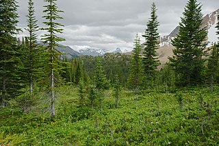
The Montane Cordillera Ecozone, as defined by the Commission for Environmental Cooperation (CEC), is an ecozone in south-central British Columbia and southwestern Alberta, Canada. A rugged and mountainous ecozone spanning 473,000 square kilometres, it still contains "two of the few significant agricultural areas of the province", the Creston Valley and the Okanagan Valley. Primarily a mountainous region, it consists of rugged ecosystems such as alpine tundra, dry sagebrush and dense conifer forests. The interior plains are encircled by a ring of mountains. The area has a mild climate throughout the year, with typically dry summers and wet winters.

The Arctic Archipelago Marine Ecozone, as defined by the Commission for Environmental Cooperation (CEC), is a marine ecozone in the Canadian Arctic, encompassing Hudson Bay, James Bay, the internal waters and some shores of the islands in the Canadian Arctic Archipelago, and the shores of the territories, northern Ontario and western Quebec. Early exploration of these waters by Europeans were conducted to find a passage to the Orient, now referred to as the Northwest Passage.
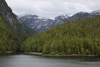
The Pacific Maritime Ecozone, as defined by the Commission for Environmental Cooperation (CEC), is a Canadian terrestrial ecozone, spanning a strip approximately 200 kilometres wide along the British Columbia Coast, then narrowing along the border with Alaska. It also includes all marine islands of British Columbia and a small portion of the southwestern corner of the Yukon. Fourteen ecoregions comprise the Ecozone, ranging from the Mount Logan Ecoregion in the north to the Cascade Ecoregion and Lower Mainland Ecoregion in the south.
The Taiga Plain Ecozone, as defined by the Commission for Environmental Cooperation (CEC), is a Canadian terrestrial ecozone that covers most of the western Northwest Territories, extending to northwest Alberta, northeast British Columbia and slightly overlapping northeastern Yukon.

The Boreal Cordillera Ecozone, as defined by the Commission for Environmental Cooperation (CEC), is a Canadian terrestrial ecozone occupying most of the northern third of British Columbia and southern half of Yukon. Within it is found Kluane National Park and Reserve, and a small portion of the southern range of Nahanni National Park Reserve. Most of the area's population is based in the city of Whitehorse, and it contains most of Yukon's population. The portion in British Columbia is barely populated.

The Northern Arctic Ecozone, as defined by the Commission for Environmental Cooperation (CEC), is a Canadian terrestrial ecozone which includes most of the Canadian Arctic Archipelago, the Boothia and Melville Peninsulas of Nunavut, and the northwestern tip of Quebec. Its marine borders are with the Arctic Archipelago Marine Ecozone, and it is adjacent to the mainland Southern Arctic Ecozone.

The interior Alaska–Yukon lowland taiga is an ecoregion in the taiga and boreal forests biome, of far northern North America.
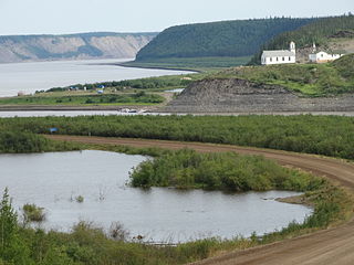
The Peel watershed drains 14% of the Yukon Territory Canada and flows into the Beaufort Sea via the Peel and then Mackenzie Rivers. While the lower part of the Peel River and its confluence with the Mackenzie River are in the North West Territories, most of the watershed, 68,000 km2 out of 77,000 km2 is in the Yukon. Six major tributaries and numerous smaller streams feed the Peel. The Yukon portion of the watershed is undergoing land use planning, a process laid out in Chapter 11 of the Yukon Land Claims Agreement and is called the Peel Watershed Planning Region (PWPR). This article is confined to the PWPR.

The Canadian Arctic tundra is a biogeographic designation for Northern Canada's terrain generally lying north of the tree line or boreal forest, that corresponds with the Scandinavian Alpine tundra to the east and the Siberian Arctic tundra to the west inside the circumpolar tundra belt of the Northern Hemisphere.

The Southern Hudson Bay taiga is a terrestrial ecoregion, as classified by the World Wildlife Fund, which extends along the southern coast of Hudson Bay and resides within the larger taiga biome. The region is nearly coterminous with the Hudson Plain, a Level I ecoregion of North America as designated by the Commission for Environmental Cooperation (CEC) in its North American Environmental Atlas.
The Northwest Territories taiga ecoregion (WWF:NA0614) is located in the Northwest Territories and Yukon provinces of Canada. It covers forest and tundra along the Mackenzie River Valley and the surrounding highlands in the southern portion of the valley.

The Ogilvie–MacKenzie alpine tundra ecoregion covers the mountainous middle of the Yukon Territory in Canada, with extensions into the Northwest Territories. The vegetation is alpine and subalpine open forest of stunted spruce, fir and pine. The area is rugged but sections appear to have been unglaciated in the late Pleistocene and there are therefore relic species in the region. The area is remote and supports large, sustainable predator-prey systems.
