Tree line

Last updated
Tree line above St. Moritz, Switzerland. May 2009 Tree line above St. Moritz.jpg
Tree line above St. Moritz, Switzerland. May 2009
In this view of an alpine tree line, the distant line looks particularly sharp. The foreground shows the transition from trees to no trees. These trees are stunted in growth and one-sided because of cold and constant wind. Tree line.jpg
In this view of an alpine tree line, the distant line looks particularly sharp. The foreground shows the transition from trees to no trees. These trees are stunted in growth and one-sided because of cold and constant wind.

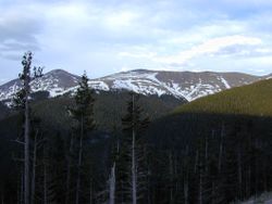
The tree line is the edge of a habitat at which trees are capable of growing and beyond which they are not. It is found at high elevations and high latitudes. Beyond the tree line, trees cannot tolerate the environmental conditions (usually low temperatures, extreme snowpack, or associated lack of available moisture). [1] :51 The tree line is sometimes distinguished from a lower timberline, which is the line below which trees form a forest with a closed canopy. [2] :151 [3] :18

Contents

At the tree line, tree growth is often sparse, stunted, and deformed by wind and cold. This is sometimes known as krummholz (German for "crooked wood"). [4] :58

The tree line often appears well-defined, but it can be a more gradual transition. Trees grow shorter and often at lower densities as they approach the tree line, above which they are unable to grow at all. [4] :55 Given a certain latitude, the tree line is approximately 300 to 1000 meters below the permanent snow line and roughly parallel to it. [5]

Causes

Due to their vertical structure, trees are more susceptible to cold than more ground-hugging forms of plants. [6] Summer warmth generally sets the limit to which tree growth can occur, for while tree line conifers are very frost-hardy during most of the year, they become sensitive to just 1 or 2 degrees of frost in mid-summer. [7] [8] A series of warm summers in the 1940s seems to have permitted the establishment of "significant numbers" of spruce seedlings above the previous treeline in the hills near Fairbanks, Alaska. [9] [10] Survival depends on a sufficiency of new growth to support the tree. Wind can mechanically damage tree tissues directly, including blasting with windborne particles, and may also contribute to the desiccation of foliage, especially of shoots that project above the snow cover.[ citation needed ]

The actual tree line is set by the mean temperature, while the realized tree line may be affected by disturbances, such as logging. [6] Most human activities cannot change the actual tree line, unless they affect the climate. [6] The tree line follows the line where the seasonal mean temperature is approximately 6 °C or 43 °F. [11] [6] The seasonal mean temperature is taken over all days whose mean temperature is above 0.9 °C (33.6 °F). A growing season of 94 days above that temperature is required for tree growth. [12]

Types

This map of the "Distribution of Plants in a Perpendicular Direction in the Torrid, the Temperate, and the Frigid Zones" was first published 1848 in "The Physical Atlas". It shows tree lines of the Andes, Tenerife, Himalaya, Alps, Pyrenees, and Lapland. Distribution of Plants in a Perpendicular Direction in the Torrid, the Temperate, and the Rigid Zones 1848 Alexander Keith Johnston.png
This map of the "Distribution of Plants in a Perpendicular Direction in the Torrid, the Temperate, and the Frigid Zones" was first published 1848 in "The Physical Atlas". It shows tree lines of the Andes, Tenerife, Himalaya, Alps, Pyrenees, and Lapland.
Alpine tree line of mountain pine and European spruce below the subalpine zone of Bistrishko Branishte, with the surmounting Golyam Rezen Peak, Vitosha Mountain, Sofia, Bulgaria Bistrishko-Branishte.jpg
Alpine tree line of mountain pine and European spruce below the subalpine zone of Bistrishko Branishte, with the surmounting Golyam Rezen Peak, Vitosha Mountain, Sofia, Bulgaria

Several types of tree lines are defined in ecology and geography:

Alpine

An alpine tree line in the Tararua Range Treeline In The Tararuas.JPG
An alpine tree line in the Tararua Range

An alpine tree line is the highest elevation that sustains trees; higher up it is too cold, or the snow cover lasts for too much of the year, to sustain trees. [2] :151 The climate above the tree line of mountains is called an alpine climate, [13] :21 and the habitat can be described as the alpine zone. [14] Treelines on north-facing slopes in the northern hemisphere are lower than on south-facing slopes, because the increased shade on north-facing slopes means the snowpack takes longer to melt. This shortens the growing season for trees. [15] :109 In the southern hemisphere, the south-facing slopes have the shorter growing season.

The alpine tree line boundary is seldom abrupt: it usually forms a transition zone between closed forest below and treeless alpine zone above. This zone of transition occurs "near the top of the tallest peaks in the northeastern United States, high up on the giant volcanoes in central Mexico, and on mountains in each of the 11 western states and throughout much of Canada and Alaska". [16] Environmentally dwarfed shrubs ( krummholz ) commonly form the upper limit.

The decrease in air temperature with increasing elevation creates the alpine climate. The rate of decrease can vary in different mountain chains, from 3.5 °F (1.9 °C) per 1,000 feet (300 m) of elevation gain in the dry mountains of the western United States, [16] to 1.4 °F (0.78 °C) per 1,000 feet (300 m) in the moister mountains of the eastern United States. [17] Skin effects and topography can create microclimates that alter the general cooling trend. [18]

Compared with arctic tree lines, alpine tree lines may receive fewer than half of the number of degree days (above 10 °C (50 °F)) based on air temperature, but because solar radiation intensities are greater at alpine than at arctic tree lines the number of degree days calculated from leaf temperatures may be very similar. [16]

At the alpine tree line, tree growth is inhibited when excessive snow lingers and shortens the growing season to the point where new growth would not have time to harden before the onset of fall frost. Moderate snowpack, however, may promote tree growth by insulating the trees from extreme cold during the winter, curtailing water loss, [19] and prolonging a supply of moisture through the early part of the growing season. However, snow accumulation in sheltered gullies in the Selkirk Mountains of southeastern British Columbia causes the tree line to be 400 metres (1,300 ft) lower than on exposed intervening shoulders. [20]

In some mountainous areas, higher elevations above the condensation line, or on equator-facing and leeward slopes, can result in low rainfall and increased exposure to solar radiation. This dries out the soil, resulting in a localized arid environment unsuitable for trees. Many south-facing ridges of the mountains of the Western U.S. have a lower treeline than the northern faces because of increased sun exposure and aridity. Hawaii's treeline of about 8,000 ft (2,400 m) feet is also above the condensation zone and results due to a lack of moisture.[ citation needed ]

Exposure

On coasts and isolated mountains, the tree line is often much lower than in corresponding altitudes inland and in larger, more complex mountain systems, because strong winds reduce tree growth. In addition, the lack of suitable soil, such as along talus slopes or exposed rock formations, prevents trees from gaining an adequate foothold and exposes them to drought and sun.

Arctic

Treeline visible in lower left, northern Quebec, Canada, while trees also grow in the sheltered river valleys. Riviere aux Melezes 1.JPG
Treeline visible in lower left, northern Quebec, Canada, while trees also grow in the sheltered river valleys.

The arctic tree line is the northernmost latitude in the Northern Hemisphere where trees can grow; farther north, it is too cold all year round to sustain trees. [21] Extremely low temperatures, especially when prolonged, can freeze the internal sap of trees, killing them. In addition, permafrost in the soil can prevent trees from getting their roots deep enough for the necessary structural support.[ citation needed ]

Unlike alpine tree lines, the northern tree line occurs at low elevations. The arctic forest–tundra transition zone in northwestern Canada varies in width, perhaps averaging 145 kilometres (90 mi) and widening markedly from west to east, [22] in contrast with the telescoped alpine timberlines. [16] North of the arctic tree line lies the low-growing tundra, and southwards lies the boreal forest.

Two zones can be distinguished in the arctic tree line: [23] [24] a forest–tundra zone of scattered patches of krummholz or stunted trees, with larger trees along rivers and on sheltered sites set in a matrix of tundra; and "open boreal forest" or "lichen woodland", consisting of open groves of erect trees underlain by a carpet of Cladonia spp. lichens. [23] The proportion of trees to lichen mat increases southwards towards the "forest line", where trees cover 50 percent or more of the landscape. [16] [25]

Antarctic

A southern treeline exists in the New Zealand Subantarctic Islands and the Australian Macquarie Island, with places where mean annual temperatures above 5 °C (41 °F) support trees and woody plants, and those below 5 °C (41 °F) do not. [26] Another treeline exists in the southwesternmost parts of the Magellanic subpolar forests ecoregion, where the forest merges into the subantarctic tundra (termed Magellanic moorland or Magellanic tundra). [27] For example, the northern halves of Hoste and Navarino Islands have Nothofagus antarctica forests but the southern parts consist of moorlands and tundra.

Tree species near tree line

Coniferous species tree line below Vihren Peak, Pirin Mountains, Bulgaria Vihren Peak.jpg
Coniferous species tree line below Vihren Peak, Pirin Mountains, Bulgaria
Dahurian larch growing close to the Arctic tree line in the Kolyma region, Arctic northeast Siberia Larix gmelinii0.jpg
Dahurian larch growing close to the Arctic tree line in the Kolyma region, Arctic northeast Siberia
View of a Magellanic lenga forest close to the tree line in Torres del Paine National Park, Chile Valle del Frances.jpg
View of a Magellanic lenga forest close to the tree line in Torres del Paine National Park, Chile

Some typical Arctic and alpine tree line tree species (note the predominance of conifers):

Australia

Eurasia

North America

South America

Worldwide distribution

Alpine tree lines

The alpine tree line at a location is dependent on local variables, such as aspect of slope, rain shadow and proximity to either geographical pole. In addition, in some tropical or island localities, the lack of biogeographical access to species that have evolved in a subalpine environment can result in lower tree lines than one might expect by climate alone.[ citation needed ]

Averaging over many locations and local microclimates, the treeline rises 75 metres (245 ft) when moving 1 degree south from 70 to 50°N, and 130 metres (430 ft) per degree from 50 to 30°N. Between 30°N and 20°S, the treeline is roughly constant, between 3,500 and 4,000 metres (11,500 and 13,100 ft). [32]

Here is a list of approximate tree lines from locations around the globe:

LocationApprox. latitudeApprox. elevation of tree lineNotes
(m)(ft)
Finnmarksvidda, Norway69°N5001,600At 71°N, near the coast, the tree-line is below sea level (Arctic tree line).
Abisko, Sweden68°N6502,100 [32]
Chugach Mountains, Alaska 61°N7002,300Tree line around 1,500 feet (460 m) or lower in coastal areas
Southern Norway61°N1,1003,600Much lower near the coast, down to 500–600 metres (1,600–2,000 ft).
Scotland, United Kingdom57°N5001,600Strong maritime influence serves to cool summer and restrict tree growth [33] :79
Northern Quebec 56°N00The cold Labrador Current originating in the arctic makes eastern Canada the sea-level region with the most southern tree-line in the northern hemisphere.
Southern Urals 55°N1,1003,600
Canadian Rockies 51°N2,4007,900
Tatra Mountains 49°N1,6005,200
Olympic Mountains WA, United States47°N1,5004,900Heavy winter snowpack buries young trees until late summer
Swiss Alps 47°N2,2007,200 [34]
Mount Katahdin, Maine, United States46°N1,1503,800
Eastern Alps, Austria, Italy46°N1,7505,700More exposure to cold Russian winds than Western Alps
Sikhote-Alin, Russia46°N1,6005,200 [35]
Alps of Piedmont, Northwestern Italy45°N2,1006,900
New Hampshire, United States44°N1,3504,400 [36] Some peaks have even lower treelines because of fire and subsequent loss of soil, such as Grand Monadnock and Mount Chocorua.
Wyoming, United States43°N3,0009,800
Caucasus Mountains 42°N2,4007,900 [37]
Rila and Pirin Mountains, Bulgaria 42°N2,3007,500Up to 2,600 m (8,500 ft) on favorable locations. Mountain Pine is the most common tree line species.
Pyrenees Spain, France, Andorra 42°N2,3007,500 Mountain Pine is the tree line species
Steens Mountain, Oregon, US42°N2,5008,200
Wasatch Mountains, Utah, United States40°N2,9009,500Higher (nearly 11,000 feet or 3,400 metres in the Uintas)
Rocky Mountain NP, CO, United States40°N3,55011,600 [32] On warm southwest slopes
3,25010,700On northeast slopes
Yosemite, CA, United States38°N3,20010,500 [38] West side of Sierra Nevada
3,60011,800 [38] East side of Sierra Nevada
Sierra Nevada, Spain37°N2,4007,900Precipitation low in summer
Japanese Alps 36°N2,9009,500
Khumbu, Himalaya 28°N4,20013,800 [32]
Yushan, Taiwan 23°N3,60011,800 [39] Strong winds and poor soil restrict further grow of trees.
Hawaii, United States20°N3,0009,800 [32] Geographic isolation and no local tree species with high tolerance to cold temperatures.
Pico de Orizaba, Mexico19°N4,00013,100 [34]
Costa Rica 9.5°N3,40011,200
Mount Kinabalu, Borneo 6.1°N3,40011,200 [40]
Mount Kilimanjaro, Tanzania 3°S3,10010,200 [32] Upper limit of forest trees; woody ericaeous scrub grows up to 3900m
New Guinea 6°S3,85012,600 [32]
Andes, Peru 11°S3,90012,800East side; on west side tree growth is restricted by dryness
Andes, Bolivia 18°S5,20017,100Western Cordillera; highest treeline in the world on the slopes of Sajama Volcano (Polylepis tarapacana)
4,10013,500Eastern Cordillera; treeline is lower because of lower solar radiation (more humid climate)
Sierra de Córdoba, Argentina 31°S2,0006,600Precipitation low above trade winds, also high exposure
Australian Alps, New South Wales, Australia 36°S
1,8005,900Despite the far inland location, summers are cool relative to the latitude, with occasional summer snow; and heavy springtime snowfalls are common [41]
Andes, Laguna del Laja, Chile 37°S1,6005,200Temperature rather than precipitation restricts tree growth [42]
Mount Taranaki, North Island, New Zealand39°S1,5004,900Strong maritime influence serves to cool summer and restrict tree growth
Northeast Tasmania, Australia 41°S1,2003,900Although sheltered on the leeward side of the island, summers are still cool for the latitude.
Southwest Tasmania, Australia 43°S7502,500Exposed to the westerly storm track, summer is extraordinarily cool for the latitude, with frequent summer snow. Springtime receives an extreme amount of cold, heavy precipitation; winds are likewise extreme.
Fiordland, South Island, New Zealand45°S9503,100Very snowy springs, strong cold winds and cool summers with frequent summer snow restrict tree growth[ citation needed ]
Lago Argentino, Argentina50°S1,0003,300 Nothofagus pumilio [43]
Torres del Paine, Chile 51°S9503,100Strong influence from the Southern Patagonian Ice Field serves to cool summer and restrict tree growth [44]
Navarino Island, Chile 55°S6002,000Strong maritime influence serves to cool summer and restrict tree growth [44]

Arctic tree lines

Map of tree line in Canada Canada tree line map.png
Map of tree line in Canada

Like the alpine tree lines shown above, polar tree lines are heavily influenced by local variables such as aspect of slope and degree of shelter. In addition, permafrost has a major impact on the ability of trees to place roots into the ground. When roots are too shallow, trees are susceptible to windthrow and erosion. Trees can often grow in river valleys at latitudes where they could not grow on a more exposed site. Maritime influences such as ocean currents also play a major role in determining how far from the equator trees can grow as well as the warm summers experienced in extreme continental climates.[ citation needed ] In northern inland Scandinavia there is substantial maritime influence on high parallels that keep winters relatively mild, but enough inland effect to have summers well above the threshold for the tree line. Here are some typical polar treelines:

LocationApprox. longitudeApprox. latitude of tree lineNotes
Norway24°E70°NThe North Atlantic current makes Arctic climates in this region warmer than other coastal locations at comparable latitude. In particular the mildness of winters prevents permafrost.
West Siberian Plain 75°E66°N
Central Siberian Plateau 102°E72°NExtreme continental climate means the summer is warm enough to allow tree growth at higher latitudes, extending to northernmost forests of the world at 72°28'N at Ary-Mas (102° 15' E) in the Novaya River valley, a tributary of the Khatanga River and the more northern Lukunsky grove at 72°31'N, 105° 03' E east from Khatanga River.
Russian Far East (Kamchatka and Chukotka)160°E60°NThe Oyashio Current and strong winds affect summer temperatures to prevent tree growth. The Aleutian Islands are almost completely treeless.
Alaska, United States152°W68°NTrees grow north to the south-facing slopes of the Brooks Range. The mountains block cold air coming off of the Arctic Ocean.
Northwest Territories, Canada132°W69°NReaches north of the Arctic Circle because of the continental nature of the climate and warmer summer temperatures.
Nunavut 95°W61°NInfluence of the very cold Hudson Bay moves the treeline southwards.
Labrador Peninsula 72°W56°NVery strong influence of the Labrador Current on summer temperatures as well as altitude effects (much of Labrador is a plateau). In parts of Labrador, the treeline extends as far south as 53°N. Along the coast the northernmost trees are at 58°N in Napartok Bay.
Greenland 50°W64°NDetermined by experimental tree planting in the absence of native trees because of isolation from natural seed sources; a very few trees are surviving, but growing slowly, at Søndre Strømfjord, 67°N. There is one natural forest in the Qinngua Valley.

Antarctic tree lines

Trees exist on Tierra del Fuego (55°S) at the southern end of South America, but generally not on subantarctic islands and not in Antarctica. Therefore, there is no explicit Antarctic tree line.

Kerguelen Island (49°S), South Georgia (54°S), and other subantarctic islands are all so heavily wind-exposed and with a too-cold summer climate (tundra) that none have any indigenous tree species. The Falkland Islands (51°S) summer temperature is near the limit, but the islands are also treeless, although some planted trees exist.

Antarctic Peninsula is the northernmost point in Antarctica (63°S) and has the mildest weather—it is located 1,080 kilometres (670 mi) from Cape Horn on Tierra del Fuego—yet no trees survive there; only a few mosses, lichens, and species of grass do so. In addition, no trees survive on any of the subantarctic islands near the peninsula.

Trees growing along the north shore of the Beagle Channel, 55degS. BeagleChannelGlacier.jpg
Trees growing along the north shore of the Beagle Channel, 55°S.

Southern Rata forests exist on Enderby Island and Auckland Islands (both 50°S) and these grow up to an elevation of 370 metres (1,200 ft) in sheltered valleys. These trees seldom grow above 3 m (9.8 ft) in height and they get smaller as one gains altitude, so that by 180 m (600 ft) they are waist-high. These islands have only between 600 and 800 hours of sun annually. Campbell Island (52°S) further south is treeless, except for one stunted Spruce, planted by scientists. [45] The climate on these islands is not severe, but tree growth is limited by almost continual rain and wind. Summers are very cold with an average January temperature of 9 °C (48 °F). Winters are mild 5 °C (41 °F) but wet. Macquarie Island (Australia) is located at 54°S and has no vegetation beyond snow grass and alpine grasses and mosses.[ citation needed ]

See also

Related Research Articles

<span class="mw-page-title-main">Tundra</span> Biome where plant growth is hindered by frigid temperatures

In physical geography, tundra is a type of biome where tree growth is hindered by frigid temperatures and short growing seasons. The term is a Russian word adapted from Sámi languages. There are three regions and associated types of tundra: Arctic tundra, alpine tundra, and Antarctic tundra.

<span class="mw-page-title-main">Taiga</span> Biome characterized by coniferous forests

Taiga, also known as boreal forest or snow forest, is a biome characterized by coniferous forests consisting mostly of pines, spruces, and larches. The taiga or boreal forest is the world's largest land biome. In North America, it covers most of inland Canada, Alaska, and parts of the northern contiguous United States. In Eurasia, it covers most of Sweden, Finland, much of Russia from Karelia in the west to the Pacific Ocean, much of Norway and Estonia, some of the Scottish Highlands, some lowland/coastal areas of Iceland, and areas of northern Kazakhstan, northern Mongolia, and northern Japan.

<span class="mw-page-title-main">Polar climate</span> Climate classification

The polar climate regions are characterized by a lack of warm summers but with varying winters. Every month a polar climate has an average temperature of less than 10 °C (50 °F). Regions with a polar climate cover more than 20% of the Earth's area. Most of these regions are far from the equator and near the poles, and in this case, winter days are extremely short and summer days are extremely long. A polar climate consists of cool summers and very cold winters, which results in treeless tundra, glaciers, or a permanent or semi-permanent layer of ice. It is identified with the letter E in the Köppen climate classification.

<span class="mw-page-title-main">Geography of Norway</span>

Norway is a country located in Northern Europe in the northern and western parts of the Scandinavian Peninsula. The majority of the country borders water, including the Skagerrak inlet to the south, the North Sea to the southwest, the North Atlantic Ocean to the west, and the Barents Sea to the north. It has a land border with Sweden to the east; to the northeast it has a shorter border with Finland and an even shorter border with Russia.

<span class="mw-page-title-main">Alpine tundra</span> Biome found at high altitudes

Alpine tundra is a type of natural region or biome that does not contain trees because it is at high elevation, with an associated harsh climate. As the latitude of a location approaches the poles, the threshold elevation for alpine tundra gets lower until it reaches sea level, and alpine tundra merges with polar tundra.

<i>Pinus albicaulis</i> Pine tree species found in North America

Pinus albicaulis, known by the common names whitebark pine, white bark pine, white pine, pitch pine, scrub pine, and creeping pine, is a conifer tree native to the mountains of the western United States and Canada, specifically subalpine areas of the Sierra Nevada, Cascade Range, Pacific Coast Ranges, and Rocky Mountains. It shares the common name "creeping pine" with several other plants.

<span class="mw-page-title-main">Alpine climate</span> Typical weather for regions above the tree line

Alpine climate is the typical climate for elevations above the tree line, where trees fail to grow due to cold. This climate is also referred to as a mountain climate or highland climate.

<i>Pinus longaeva</i> Long-living species of bristlecone pine tree found in the western United States

Pinus longaeva is a long-living species of bristlecone pine tree found in the higher mountains of California, Nevada, and Utah. Methuselah is a bristlecone pine that is 4,855 years old and has been credited as the oldest known living non-clonal organism on Earth. To protect it, the exact location of this tree is kept secret. In 1987, the bristlecone pine was designated one of Nevada's state trees.

<span class="mw-page-title-main">Alpine plant</span> Plants that grow at high elevation

Alpine plants are plants that grow in an alpine climate, which occurs at high elevation and above the tree line. There are many different plant species and taxa that grow as a plant community in these alpine tundra. These include perennial grasses, sedges, forbs, cushion plants, mosses, and lichens. Alpine plants are adapted to the harsh conditions of the alpine environment, which include low temperatures, dryness, ultraviolet radiation, wind, drought, poor nutritional soil, and a short growing season.

<span class="mw-page-title-main">Scandinavian montane birch forest and grasslands</span> Tundra ecoregion in Scandinavia

The Scandinavian montane birch forests and grasslands is defined by the World Wildlife Fund (WWF) as a terrestrial tundra ecoregion in Norway, Sweden, and Finland.

<span class="mw-page-title-main">Sierra Nevada subalpine zone</span> Biotic zone in California, United States

The Sierra Nevada subalpine zone refers to a biotic zone below treeline in the Sierra Nevada mountain range of California, United States. This subalpine zone is positioned between the upper montane zone at its lower limit, and tree line at its upper limit.

<span class="mw-page-title-main">Arctic vegetation</span> Plants adapted to the short, cold growing seasons of the Arctic regions

About 1,702 species of plants live on the Arctic tundra, including flowering plants, short shrubs, herbs, grasses, and mosses. These plants are adapted to short, cold growing seasons. They have the ability to withstand extremely cold temperatures in the winter, and grow and reproduce in summer conditions that are quite limiting.

<i>Krummholz</i> Type of stunted, deformed vegetation encountered in subarctic and subalpine tree line landscapes

Krummholz — also called knieholz — is a type of stunted, deformed vegetation encountered in the subarctic and subalpine tree line landscapes, shaped by continual exposure to fierce, freezing winds. Under these conditions, trees can only survive where they are sheltered by rock formations or snow cover. As the lower portion of these trees continues to grow, the coverage becomes extremely dense near the ground. In Newfoundland and Labrador, the formation is known as tuckamore. Krummholz trees are also found on beaches such as the Oregon coast, where trees can become much taller than their subalpine cousins.

Altitudinal zonation in mountainous regions describes the natural layering of ecosystems that occurs at distinct elevations due to varying environmental conditions. Temperature, humidity, soil composition, and solar radiation are important factors in determining altitudinal zones, which consequently support different vegetation and animal species. Altitudinal zonation was first hypothesized by geographer Alexander von Humboldt who noticed that temperature drops with increasing elevation. Zonation also occurs in intertidal and marine environments, as well as on shorelines and in wetlands. Scientist C. Hart Merriam observed that changes in vegetation and animals in altitudinal zones map onto changes expected with increased latitude in his concept of life zones. Today, altitudinal zonation represents a core concept in mountain research.

<span class="mw-page-title-main">Cushion plant</span> Plant life-form

A cushion plant is a compact, low-growing, mat-forming plant that is found in alpine, subalpine, arctic, or subarctic environments around the world. The term "cushion" is usually applied to woody plants that grow as spreading mats, are limited in height above the ground, have relatively large and deep tap roots, and have life histories adapted to slow growth in a nutrient-poor environment with delayed reproductivity and reproductive cycle adaptations. The plant form is an example of parallel or convergent evolution with species from many different plant families on different continents converging on the same evolutionary adaptations to endure the harsh environmental conditions.

<span class="mw-page-title-main">Ecology of the North Cascades</span> Ecosystems of the Cascade mountain range in northern Washington state and southern British Columbia

The Ecology of the North Cascades is heavily influenced by the high elevation and rain shadow effects of the mountain range. The North Cascades is a section of the Cascade Range from the South Fork of the Snoqualmie River in Washington, United States, to the confluence of the Thompson and Fraser Rivers in British Columbia, Canada, where the range is officially called the Cascade Mountains but is usually referred to as the Canadian Cascades. The North Cascades Ecoregion is a Level III ecoregion in the Commission for Environmental Cooperation's classification system.

<span class="mw-page-title-main">Ecology of the Rocky Mountains</span> Ecology of the Rocky Mountain range in North America

The ecology of the Rocky Mountains is diverse due to the effects of a variety of environmental factors. The Rocky Mountains are the major mountain range in western North America, running from the far north of British Columbia in Canada to New Mexico in the southwestern United States, climbing from the Great Plains at or below 1,800 feet (550 m) to peaks of over 14,000 feet (4,300 m). Temperature and rainfall varies greatly also and thus the Rockies are home to a mixture of habitats including the alpine, subalpine and boreal habitats of the Northern Rocky Mountains in British Columbia and Alberta, the coniferous forests of Montana and Idaho, the wetlands and prairie where the Rockies meet the plains, a different mix of conifers on the Yellowstone Plateau in Wyoming, the montane forests of Utah, and in the high Rockies of Colorado and New Mexico, and finally the alpine tundra of the highest elevations.

<span class="mw-page-title-main">Montane ecosystems</span> Ecosystems found in mountains

Montane ecosystems are found on the slopes of mountains. The alpine climate in these regions strongly affects the ecosystem because temperatures fall as elevation increases, causing the ecosystem to stratify. This stratification is a crucial factor in shaping plant community, biodiversity, metabolic processes and ecosystem dynamics for montane ecosystems. Dense montane forests are common at moderate elevations, due to moderate temperatures and high rainfall. At higher elevations, the climate is harsher, with lower temperatures and higher winds, preventing the growth of trees and causing the plant community to transition to montane grasslands and shrublands or alpine tundra. Due to the unique climate conditions of montane ecosystems, they contain increased numbers of endemic species. Montane ecosystems also exhibit variation in ecosystem services, which include carbon storage and water supply.

<span class="mw-page-title-main">Wildlife of Norway</span>

The wildlife of Norway includes the diverse flora and fauna of Norway. The habitats include high mountains, tundras, rivers, lakes, wetlands, sea coast and some lower cultivated land in the south. Mainland Norway has a long coastline, protected by skerries and much dissected by fjords, and the mostly-icebound archipelago of Svalbard lies further north. The flora is very varied and a large range of mammals, birds, fish and invertebrate species live here, as well as a few species of reptiles and amphibians.

<span class="mw-page-title-main">Koh-e Keshni Khan</span> Mountain in the Afghanistani Hindu Kush

Koh-e Keshni Khan is a 6755-meter-high mountain in the eastern Hindukush range, Wakhan Corridor, Afghanistan. It is the 30th highest mountain in the country. It has a prominence of 292 metres (958 ft), which is extremely low given the altitude, but this is likely due to the fact that ridges surround the mountain. The mountain, along with all of the eastern Hindukush, is heavily glaciated starting from a very low altitude. The temperature tree line is at 10,800 feet (3,300 m). The nearest higher-elevation peak to the mountain is Kuh-e Keshni Khan, which is 2.1 kilometres (1.3 mi) away.

References

  1. 1 2 Elliott-Fisk, D.L. (2000). "The Taiga and Boreal Forest". In Barbour, M.G.; Billings, M.D. (eds.). North American Terrestrial Vegetation (2nd ed.). Cambridge University Press. ISBN   978-0-521-55986-7.
  2. 1 2 Jørgensen, S.E. (2009). Ecosystem Ecology. Academic Press. ISBN   978-0-444-53466-8.
  3. Körner, C. (2012). Alpine Treelines: Functional Ecology of the Global High Elevation Tree Limits. Illustrated by S. Riedl. Springer. ISBN   978-3-0348-0396-0.
  4. 1 2 Zwinger, A.; Willard, B.E. (1996). Land Above the Trees: A Guide to American Alpine Tundra. Big Earth Publishing. ISBN   978-1-55566-171-7.
  5. "Why treelines?".
  6. 1 2 3 4 Körner, Christian (November 1, 2021). "The cold range limit of trees". Trends in Ecology & Evolution. 36 (11): 979–989. doi:10.1016/j.tree.2021.06.011. PMID   34272073. S2CID   235999977.
  7. Tranquillini, W. (1979). Physiological Ecology of the Alpine Timberline: tree existence at high altitudes with special reference to the European Alps. New York, NY: Springer-Verlag. ISBN   978-3-642-67107-4.
  8. Coates, K.D.; Haeussler, S.; Lindeburgh, S; Pojar, R.; Stock, A.J. (1994). Ecology and silviculture of interior spruce in British Columbia. OCLC   66824523.
  9. Viereck, L.A. (1979). "Characteristics of treeline plant communities in Alaska". Holarctic Ecology . 2 (4): 228–238. JSTOR   3682417.
  10. Viereck, L.A.; Van Cleve, K.; Dyrness, C. T. (1986). "Forest ecosystem distribution in the taiga environment". In Van Cleve, K.; Chapin, F.S.; Flanagan, P.W.; Viereck, L.A.; Dyrness, C.T. (eds.). Forest Ecosystems in the Alaskan Taiga. New York, NY: Springer-Verlag. pp. 22–43. doi:10.1007/978-1-4612-4902-3_3. ISBN   978-1-4612-4902-3.
  11. Körner, Christian; Paulsen, Jens (May 2004). "A World-Wide Study of High Altitude Treeline Temperatures". J. Biogeogr. 31 (5): 713–732. doi:10.1111/j.1365-2699.2003.01043.x. JSTOR   3554841. S2CID   59025355.
  12. Paulsen, Jens; Körner, Christian (2014). "A climate-based model to predict potential treeline position around the globe" (PDF). Alpine Botany. 124: 1–12. doi:10.1007/s00035-014-0124-0. S2CID   8752987.
  13. Körner, C (2003). Alpine plant life: functional plant ecology of high mountain ecosystems. Springer. ISBN   978-3-540-00347-2.
  14. "Alpine Tundra Ecosystem". Rocky Mountain National Park. National Park Service. Retrieved 2011-05-13.
  15. 1 2 3 Peet, R.K. (2000). "Forests and Meadows of the Rocky Mountains". In Barbour, M.G.; Billings, M.D. (eds.). North American Terrestrial Vegetation (2nd ed.). Cambridge University Press. ISBN   978-0-521-55986-7.
  16. 1 2 3 4 5 Arno, S.F. (1984). Timberline: Mountain and Arctic Forest Frontiers. Seattle, WA: The Mountaineers. ISBN   978-0-89886-085-6.
  17. Baker, F.S. (1944). "Mountain climates of the western United States". Ecological Monographs . 14 (2): 223–254. doi:10.2307/1943534. JSTOR   1943534.
  18. Geiger, R. (1950). The Climate near the Ground. Cambridge, MA: Harvard University Press.
  19. Sowell, J.B.; McNulty, S.P.; Schilling, B.K. (1996). "The role of stem recharge in reducing the winter desiccation of Picea engelmannii (Pinaceae) needles at alpine timberline". American Journal of Botany . 83 (10): 1351–1355. doi:10.2307/2446122. JSTOR   2446122.
  20. Shaw, C.H. (1909). "The causes of timberline on mountains: the role of snow". Plant World. 12: 169–181.
  21. Pienitz, Reinhard; Douglas, Marianne S. V.; Smol, John P. (2004). Long-term environmental change in Arctic and Antarctic lakes. Springer. p. 102. ISBN   978-1-4020-2126-8.
  22. Timoney, K.P.; La Roi, G.H.; Zoltai, S.C.; Robinson, A.L. (1992). "The high subarctic forest–tundra of northwestern Canada: position, width, and vegetation gradients in relation to climate". Arctic. 45 (1): 1–9. doi: 10.14430/arctic1367 . JSTOR   40511186.
  23. 1 2 Löve, Dd (1970). "Subarctic and subalpine: where and what?". Arctic and Alpine Research . 2 (1): 63–73. doi:10.2307/1550141. JSTOR   1550141.
  24. Hare, F. Kenneth; Ritchie, J.C. (1972). "The boreal bioclimates". Geographical Review . 62 (3): 333–365. doi:10.2307/213287. JSTOR   213287.
  25. R.A., Black; Bliss, L.C. (1978). "Recovery sequence of Picea mariana–Vaccinium uliginosum forests after burning near Inuvik, Northwest Territories, Canada". Canadian Journal of Botany . 56 (6): 2020–2030. doi:10.1139/b78-243.
  26. "Antipodes Subantarctic Islands tundra". Terrestrial Ecoregions. World Wildlife Fund.
  27. "Magellanic subpolar Nothofagus forests". Terrestrial Ecoregions. World Wildlife Fund.
  28. Chalupa, V. (1992). "Micropropagation of European Mountain Ash (Sorbus aucuparia L.) and Wild Service Tree [Sorbus torminalis (L.) Cr.]". In Bajaj, Y.P.S. (ed.). High-Tech and Micropropagation II. Biotechnology in Agriculture and Forestry. Vol. 18. Springer Berlin Heidelberg. pp. 211–226. doi:10.1007/978-3-642-76422-6_11. ISBN   978-3-642-76424-0.
  29. 1 2 "Treeline". The Canadian Encyclopedia. Archived from the original on 2010-12-03. Retrieved 2011-06-22.
  30. Fajardo, A; Piper, FI; Cavieres, LA (2011). "Distinguishing local from global climate influences in the variation of carbon status with altitude in a tree line species". Global Ecology and Biogeography. 20 (2): 307–318. doi:10.1111/j.1466-8238.2010.00598.x. hdl: 10533/134794 .
  31. Dickinson, Joshua C. (1969). "The Eucalypt in the Sierra of Southern Peru". Annals of the Association of American Geographers. 59 (2): 294–307. doi:10.1111/j.1467-8306.1969.tb00672.x. ISSN   0004-5608. JSTOR   2561632.
  32. 1 2 3 4 5 6 7 Körner, Ch (1998). "A re-assessment of high elevation treeline positions and their explanation". Oecologia. 115 (4): 445–459. Bibcode:1998Oecol.115..445K. CiteSeerX   10.1.1.454.8501 . doi:10.1007/s004420050540. PMID   28308263. S2CID   8647814.
  33. "Action For Scotland's Biodiversity" (PDF).
  34. 1 2 Körner, Ch. "High Elevation Treeline Research". Archived from the original on 2011-09-27. Retrieved 2010-06-14.
  35. "Physiogeography of the Russian Far East".
  36. "Mount Washington State Park". New Hampshire State Parks. Archived from the original on 2013-04-03. Retrieved 2013-08-22. Tree line, the elevation above which trees do not grow, is about 4,400 feet in the White Mountains, nearly 2,000 feet below the summit of Mt. Washington.
  37. "Georgia's natural resources and conservation" (PDF). geostat.ge (in Georgian). National Statistic Office of Georgia. Retrieved 2023-04-13.
  38. 1 2 Schoenherr, Allan A. (1995). A Natural History of California. UC Press. ISBN   978-0-520-06922-0.
  39. "台灣地帶性植被之區劃與植物區系之分區" (PDF). Archived from the original (PDF) on 2014-11-29.
  40. "Mount Kinabalu National Park". www.ecologyasia.com. Ecology Asia. 4 September 2016. Retrieved 6 September 2016.
  41. "Alpine trees | ANU Research School of Biology".
  42. Lara, Antonio; Villalba, Ricardo; Wolodarsky-Franke, Alexia; Aravena, Juan Carlos; Luckman, Brian H.; Cuq, Emilio (2005). "Spatial and temporal variation in Nothofagus pumilio growth at tree line along its latitudinal range (35°40′–55° S) in the Chilean Andes" (PDF). Journal of Biogeography . 32 (5): 879–893. doi:10.1111/j.1365-2699.2005.01191.x. S2CID   51845387.
  43. Sottile, Gonzalo D.; Echeverría, Marcos E.; Tonello, Marcela S.; Marcos, María A.; Bamonte, Florencia P.; Rayó, Cecilia; Mancini, María V. (2020). "Dinámica de la vegetación andina del lago Argentino (50° S, 72° O) desde el retiro de los glaciares (ca. 12.000 años cal AP)". Andean Geology (in Spanish). 47 (3): 599–627. doi: 10.5027/andgeoV47n3-3303 . hdl: 11336/141218 .
  44. 1 2 Aravena, Juan C.; Lara, Antonio; Wolodarsky-Franke, Alexia; Villalba, Ricardo; Cuq, Emilio (2002). "Tree-ring growth patterns and temperature reconstruction from Nothofagus pumilio (Fagaceae) forests at the upper tree line of southern, Chilean Patagonia". Revista Chilena de Historia Natural . 75 (2). doi: 10.4067/S0716-078X2002000200008 . hdl: 11336/40918 .
  45. kimberleycollins (2012-04-12). "The Lone Tree of Campbell Island". Toroa. Retrieved 2021-09-05.

Further reading