Jet streams are fast flowing, narrow, meandering air currents in the atmospheres of the Earth, Venus, Jupiter, Saturn, Uranus, and Neptune. On Earth, the main jet streams are located near the altitude of the tropopause and are westerly winds. Jet streams may start, stop, split into two or more parts, combine into one stream, or flow in various directions including opposite to the direction of the remainder of the jet.

An anticyclone is a weather phenomenon defined as a large-scale circulation of winds around a central region of high atmospheric pressure, clockwise in the Northern Hemisphere and counterclockwise in the Southern Hemisphere as viewed from above. Effects of surface-based anticyclones include clearing skies as well as cooler, drier air. Fog can also form overnight within a region of higher pressure.

El Niño–Southern Oscillation (ENSO) is a global climate phenomenon that emerges from variations in winds and sea surface temperatures over the tropical Pacific Ocean. Those variations have an irregular pattern but do have some semblance of cycles. The occurrence of ENSO is not predictable. It affects the climate of much of the tropics and subtropics, and has links (teleconnections) to higher-latitude regions of the world. The warming phase of the sea surface temperature is known as "El Niño" and the cooling phase as "La Niña". The Southern Oscillation is the accompanying atmospheric oscillation, which is coupled with the sea temperature change.
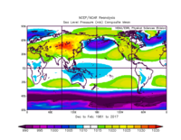
The North Atlantic Oscillation (NAO) is a weather phenomenon over the North Atlantic Ocean of fluctuations in the difference of atmospheric pressure at sea level (SLP) between the Icelandic Low and the Azores High. Through fluctuations in the strength of the Icelandic Low and the Azores High, it controls the strength and direction of westerly winds and location of storm tracks across the North Atlantic.

A high-pressure area, high, or anticyclone, is an area near the surface of a planet where the atmospheric pressure is greater than the pressure in the surrounding regions. Highs are middle-scale meteorological features that result from interplays between the relatively larger-scale dynamics of an entire planet's atmospheric circulation.

In meteorology, a low-pressure area, low area or low is a region where the atmospheric pressure is lower than that of surrounding locations. Low-pressure areas are commonly associated with inclement weather, while high-pressure areas are associated with lighter winds and clear skies. Winds circle anti-clockwise around lows in the northern hemisphere, and clockwise in the southern hemisphere, due to opposing Coriolis forces. Low-pressure systems form under areas of wind divergence that occur in the upper levels of the atmosphere (aloft). The formation process of a low-pressure area is known as cyclogenesis. In meteorology, atmospheric divergence aloft occurs in two kinds of places:

The westerlies, anti-trades, or prevailing westerlies, are prevailing winds from the west toward the east in the middle latitudes between 30 and 60 degrees latitude. They originate from the high-pressure areas in the horse latitudes and trend towards the poles and steer extratropical cyclones in this general manner. Tropical cyclones which cross the subtropical ridge axis into the westerlies recurve due to the increased westerly flow. The winds are predominantly from the southwest in the Northern Hemisphere and from the northwest in the Southern Hemisphere.

The Arctic oscillation (AO) or Northern Annular Mode/Northern Hemisphere Annular Mode (NAM) is a weather phenomenon at the Arctic pole north of 55 degrees latitude. It is an important mode of climate variability for the Northern Hemisphere. The southern hemisphere analogue is called the Antarctic oscillation or Southern Annular Mode (SAM). The index varies over time with no particular periodicity, and is characterized by non-seasonal sea-level pressure anomalies of one sign in the Arctic, balanced by anomalies of opposite sign centered at about 37–45° N.
In climatology, the term microthermal is used to denote the continental climates of Eurasia and North America.
The North American High is an impermanent high-pressure area or anticyclone created by a formative process that occurs when cool or cold dry air settles over North America. During summer, it is replaced with an Arctic Low, or a North American Low should it move over continental land.

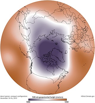
A circumpolar vortex, or simply polar vortex, is a large region of cold, rotating air; polar vortices encircle both of Earth's polar regions. Polar vortices also exist on other rotating, low-obliquity planetary bodies. The term polar vortex can be used to describe two distinct phenomena; the stratospheric polar vortex, and the tropospheric polar vortex. The stratospheric and tropospheric polar vortices both rotate in the direction of the Earth's spin, but they are distinct phenomena that have different sizes, structures, seasonal cycles, and impacts on weather.

Blocks in meteorology are large-scale patterns in the atmospheric pressure field that are nearly stationary, effectively "blocking" or redirecting migratory cyclones. They are also known as blocking highs or blocking anticyclones. These blocks can remain in place for several days or even weeks, causing the areas affected by them to have the same kind of weather for an extended period of time. In the Northern Hemisphere, extended blocking occurs most frequently in the spring over the eastern Pacific and Atlantic Oceans. Whilst these events are linked to the occurrence of extreme weather events such as heat waves, particularly the onset and decay of these events is still not well captured in numerical weather forecasts and remains an open area of research.
Yedoma is an organic-rich Pleistocene-age permafrost with ice content of 50–90% by volume. Yedoma are abundant in the cold regions of eastern Siberia, such as northern Yakutia, as well as in Alaska and the Yukon.

The Pacific–North American teleconnection pattern (PNA) is a large-scale weather pattern with two modes, denoted positive and negative, and which relates the atmospheric circulation pattern over the North Pacific Ocean with the one over the North American continent. It is the second leading mode of natural climate variability in the higher latitudes of the Northern Hemisphere and can be diagnosed using the arrangement of anomalous geopotential heights or air pressures over the North Pacific and North America.

Polar amplification is the phenomenon that any change in the net radiation balance tends to produce a larger change in temperature near the poles than in the planetary average. This is commonly referred to as the ratio of polar warming to tropical warming. On a planet with an atmosphere that can restrict emission of longwave radiation to space, surface temperatures will be warmer than a simple planetary equilibrium temperature calculation would predict. Where the atmosphere or an extensive ocean is able to transport heat polewards, the poles will be warmer and equatorial regions cooler than their local net radiation balances would predict. The poles will experience the most cooling when the global-mean temperature is lower relative to a reference climate; alternatively, the poles will experience the greatest warming when the global-mean temperature is higher.
The Arctic dipole anomaly is a pressure pattern characterized by high pressure on the arctic regions of North America and low pressure on those of Eurasia. This pattern sometimes replaces the Arctic oscillation and the North Atlantic oscillation. It was observed for the first time in the first decade of 2000s and is perhaps linked to recent climate change. The Arctic dipole lets more southern winds into the Arctic Ocean resulting in more ice melting. The summer 2007 event played an important role in the record low sea ice extent which was recorded in September. The Arctic dipole has also been linked to changes in arctic circulation patterns that cause drier winters in Northern Europe, but much wetter winters in Southern Europe and colder winters in East Asia, Europe and the eastern half of North America.

Sea ice in the Arctic region has declined in recent decades in area and volume due to climate change. It has been melting more in summer than it refreezes in winter. Global warming, caused by greenhouse gas forcing is responsible for the decline in Arctic sea ice. The decline of sea ice in the Arctic has been accelerating during the early twenty-first century, with a decline rate of 4.7% per decade. Summertime sea ice will likely cease to exist sometime during the 21st century.
Centers of action are extensive and almost stationary low or high pressure areas which control the movement of atmospheric disturbances over a large area. This does not mean that the position of the center is constant over a specific area but that the monthly atmospheric pressure corresponds to a high or a low pressure.

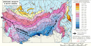
Voeykov axis is the axial portion (ridge) of a high atmospheric pressure band stretching across Eurasia roughly along the 50th parallel. It was named in honor of Alexander Voeikov, a climatologist, who studied this phenomenon.

Pacific Meridional Mode (PMM) is a climate mode in the North Pacific. In its positive state, it is characterized by the coupling of weaker trade winds in the northeast Pacific Ocean between Hawaii and Baja California with decreased evaporation over the ocean, thus increasing sea surface temperatures (SST); and the reverse during its negative state. This coupling develops during the winter months and spreads southwestward towards the equator and the central and western Pacific during spring, until it reaches the Intertropical Convergence Zone (ITCZ), which tends to shift north in response to a positive PMM.


