
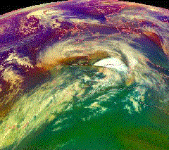
The Burns' Day Storm was an extremely violent windstorm that took place on 25–26 January 1990 over North-Western Europe. It is one of the strongest European windstorms on record and caused many fatalities in the UK and Europe. This storm has received different names, as there was no official list of such events in Europe at the time. Starting on Burns Day, the birthday of the Scottish poet Robert Burns, it caused widespread damage and hurricane-force winds over a wide area.
European windstorms are powerful extratropical cyclones which form as cyclonic windstorms associated with areas of low atmospheric pressure. They can occur throughout the year, but are most frequent between October and March, with peak intensity in the winter months. Deep areas of low pressure are common over the North Atlantic, and occasionally start as nor'easters off the New England coast. They frequently track across the North Atlantic Ocean towards the north of Scotland and into the Norwegian Sea, which generally minimizes the impact to inland areas; however, if the track is further south, it may cause adverse weather conditions across Central Europe, Northern Europe and especially Western Europe. The countries most commonly affected include the United Kingdom, Ireland, the Netherlands, Norway, Germany, the Faroe Islands and Iceland.
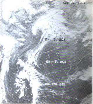
Cyclone Martin was an extremely violent European windstorm which crossed southern Europe on 27–28 December 1999, causing severe damage across France, Spain, Switzerland and Italy one day after Cyclone Lothar had affected more northerly areas. Wind speeds reached around 200 km/h (120 mph) in French department of Charente-Maritime. The storm caused 30 fatalities and €6 billion in damages. Combined with Lothar, Cyclone Martin is often referred to as the Storm of the Century in western and central Europe.
Cyclone Ulli was an intense European windstorm. Forming on December 31, 2011 off the coast of New Jersey, Ulli began a rapid strengthening phase on January 2 as it sped across the Atlantic. Ulli was the costliest disaster in January 2012 globally. The damage from the storm in Glasgow was also compared to a storm in 1968.

Cyclone Dagmar and as Cyclone Patrick by the Free University of Berlin) was a powerful European windstorm which swept over Norway on Christmas Day 2011, causing severe damage in central coastal areas, before continuing over the Scandinavian peninsula towards the Baltic Sea and Gulf of Finland. The storm caused $45 million in damage.

Cyclone Andrea was an intense European windstorm that affected western and central Europe in early January 2012.
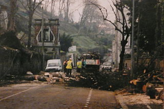
The Gale of January 1976, widely known as the "Capella" storm in Germany and the Ruisbroek flood in Belgium, was one in a series of extratropical cyclones and storm surges, which occurred over January 1976. The gale of 2–5 January 1976 resulted in severe wind damage across western and central Europe and coastal flooding around the southern North Sea coasts. At the time, this was the most severe storm of the century over the British Isles. Total fatalities reached 82 across Europe, although a figure of 100 is given by the World Meteorological Organization. Of these 24 were reported in Britain and 4 in Ireland. Overall losses of US$1.3 billion were incurred, with insured losses standing at US$500 million (1976).

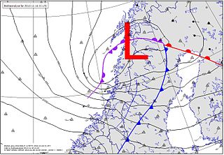
The St. Jude storm, also known as Cyclone Christian, and other names, was a severe hurricane-force European windstorm that hit Northwestern Europe on 27 and 28 October 2013 causing at least 17 deaths. The highest windspeed was in Denmark, where a gust of 194.4 km/h (120.8 mph) was recorded in the south of the country on the afternoon of 28 October, the strongest wind recorded in the country's history.
2013 Nordic storms were a series of storms affecting predominantly the Nordic nations with other northern European nations also affected. The first storm in the series Hilde, named Otto by Free University of Berlin, and Eino in Finland was an extratropical cyclone affecting parts of northern Europe, causing disruption to electricity supplies and transportation across mid Norway, northern Sweden and central Finland during 15–18 November 2013. The storm brought a new record average wind speed to Sweden, however wind speeds at lower altitudes were less than seen during Cyclone Dagmar of 2011. Most damage was caused by falling trees along the storm's path likely exacerbated by unfrozen ground. The total cost of damage is likely to be low, as the storm passed over relatively unpopulated regions of the Nordic nations.

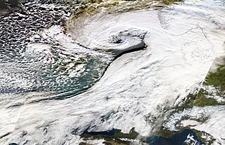
Cyclone Xaver, also known as the North Sea flood or tidal surge of 2013, was a winter storm that affected northern Europe. Force 12 winds and heavy snowfall were predicted along the storm's path, and there were warnings of a significant risk of storm surge leading to coastal flooding along the coasts of the North and Irish Seas.
The 2015–16 UK and Ireland windstorm season was the first instance of the United Kingdom's Met Office and Ireland's Met Éireann naming extratropical cyclones. The season started on 10 November with the naming of Storm Abigail and ended on 28 March with the dissipation of Storm Katie. With a total of eleven named storms, the 2015–16 season is the most active to date.
The 2018–2019 European windstorm season was the fourth instance of seasonal European windstorm naming in Europe. Most storms form between September and March. The first named storm, Ali, affected primarily the United Kingdom and Ireland on 19 September 2018.

The 2019–20 European windstorm season was the fifth instance of seasonal European windstorm naming in Europe. This is the first season in which the Netherlands meteorological authority took part, joining those of Ireland and the United Kingdom. It comprised a year from 1 September to 31 August, however names were announced six days into that year. The Portuguese, Spanish and French meteorological agencies again collaborated too, joined by the Belgian meteorological agency.
The 2020–2021 European windstorm season was the sixth instance of seasonal European windstorm naming in Europe. This is the second season in which the Netherlands participates, joining Ireland's and the United Kingdom's meteorological agencies. It comprised a year from 1 September to 31 August. The Portuguese, Spanish, and French meteorological agencies will again collaborate too, joined by the Belgian meteorological agency.

The 2021–22 European windstorm season was the seventh instance of seasonal European windstorm naming in Europe. This was the third season in which the Netherlands participated, alongside the meteorological agencies of Ireland and the United Kingdom. It comprised a year from 1 September to 31 August, except in the Eastern Mediterranean Group which is shifted a month later. The Portuguese, Spanish, French and Belgian meteorological agencies collaborated again, for the fifth time, joined by the Luxembourg meteorological agency. This was the first season when Greece, Israel and Cyprus, and Italy, Slovenia, Croatia, Montenegro, North Macedonia and Malta named storms which affected their areas.

Storm Aurore was a notably early extratropical cyclone in late October 2021 that impacted several areas of Europe, causing substantial damages. The third named storm of the 2021–22 European windstorm season, Aurore was first noted on 20 October by Meteo France over the Atlantic Ocean, south of Ireland. As the system moved over central Europe on the next day, it subsequently merged with another extratropical cyclone named Hendrik before moving across central Europe, in which it brought several destruction across the region. It then was last noted on 23 October.

Storm Eunice was an extremely powerful extratropical cyclone with hurricane-force winds that was part of the 2021–2022 European windstorm season. Storm Eunice was named by the UK Met Office on 14 February 2022. A red weather warning was issued on 17 February for parts of South West England and South Wales, with a second red warning issued on 18 February, the day the storm struck, for London, the South East and East of England.

The 2022–23 European windstorm season was the deadliest and costliest European windstorm season on record, mainly because of the impact in Northern Libya of Storm Daniel, which became the deadliest and costliest medicane ever recorded as well as the deadliest tropical or subtropical system worldwide since 2008.
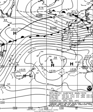
The storm Andrea was an intense depression that swept through Western and Northern Europe in early January 2012. It resulted in one fatality and caused 300 million Euros in damages. The winds damaged buildings and trees, causing power outages. Heavy rains and storm surges led to flooding, while snow trapped numerous villages in the mountains.

