
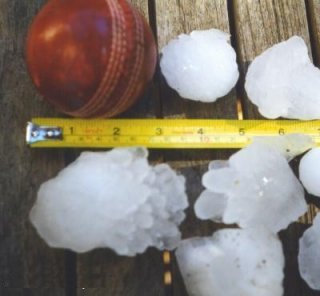
Hail is a form of solid precipitation. It is distinct from ice pellets, though the two are often confused. It consists of balls or irregular lumps of ice, each of which is called a hailstone. Ice pellets generally fall in cold weather, while hail growth is greatly inhibited during low surface temperatures.

Cumulonimbus is a dense, towering, vertical cloud, typically forming from water vapor condensing in the lower troposphere that builds upward carried by powerful buoyant air currents. Above the lower portions of the cumulonimbus the water vapor becomes ice crystals, such as snow and graupel, the interaction of which can lead to hail and to lightning formation, respectively.

A thunderstorm, also known as an electrical storm or a lightning storm, is a storm characterized by the presence of lightning and its acoustic effect on the Earth's atmosphere, known as thunder. Relatively weak thunderstorms are sometimes called thundershowers. Thunderstorms occur in a type of cloud known as a cumulonimbus. They are usually accompanied by strong winds and often produce heavy rain and sometimes snow, sleet, or hail, but some thunderstorms produce little precipitation or no precipitation at all. Thunderstorms may line up in a series or become a rainband, known as a squall line. Strong or severe thunderstorms include some of the most dangerous weather phenomena, including large hail, strong winds, and tornadoes. Some of the most persistent severe thunderstorms, known as supercells, rotate as do cyclones. While most thunderstorms move with the mean wind flow through the layer of the troposphere that they occupy, vertical wind shear sometimes causes a deviation in their course at a right angle to the wind shear direction.

A storm is any disturbed state of the natural environment or the atmosphere of an astronomical body. It may be marked by significant disruptions to normal conditions such as strong wind, tornadoes, hail, thunder and lightning, heavy precipitation, heavy freezing rain, strong winds, wind transporting some substance through the atmosphere such as in a dust storm, among other forms of severe weather.

A supercell is a thunderstorm characterized by the presence of a mesocyclone, a deep, persistently rotating updraft. Due to this, these storms are sometimes referred to as rotating thunderstorms. Of the four classifications of thunderstorms, supercells are the overall least common and have the potential to be the most severe. Supercells are often isolated from other thunderstorms, and can dominate the local weather up to 32 kilometres (20 mi) away. They tend to last 2–4 hours.

A squall line, or quasi-linear convective system (QLCS), is a line of thunderstorms, often forming along or ahead of a cold front. In the early 20th century, the term was used as a synonym for cold front. Linear thunderstorm structures often contain heavy precipitation, hail, frequent lightning, strong straight-line winds, and occasionally tornadoes or waterspouts. Particularly strong straight-line winds can occur where the linear structure forms into the shape of a bow echo. Tornadoes can occur along waves within a line echo wave pattern (LEWP), where mesoscale low-pressure areas are present. Some bow echoes can grow to become derechos as they move swiftly across a large area. On the back edge of the rainband associated with mature squall lines, a wake low can be present, on very rare occasions associated with a heat burst.

Severe storms in Australia refers to the storms, including cyclones, which have caused severe damage in Australia.
Severe weather is any dangerous meteorological phenomenon with the potential to cause damage, serious social disruption, or loss of human life. These vary depending on the latitude, altitude, topography, and atmospheric conditions. High winds, hail, excessive precipitation, and wildfires are forms and effects, as are thunderstorms, downbursts, tornadoes, waterspouts, tropical cyclones, and extratropical cyclones. Regional and seasonal phenomena include blizzards,snowstorms, ice storms, and duststorms.

Atmospheric convection is the result of a parcel-environment instability in the atmosphere. Different lapse rates within dry and moist air masses lead to instability. Mixing of air during the day expands the height of the planetary boundary layer, leading to increased winds, cumulus cloud development, and decreased surface dew points. Convection involving moist air masses leads to thunderstorm development, which is often responsible for severe weather throughout the world. Special threats from thunderstorms include hail, downbursts, and tornadoes.

The British Isles are an archipelago off the northwest coast of Europe, consisting of the islands of Great Britain and Ireland along with smaller surrounding ones. Its position allows dry continental air from Eurasia to meet wetter air from the Atlantic Ocean, which causes the weather to be highly variable, often changing many times during the day. It is defined as a temperate oceanic climate, or Cfb on the Köppen climate classification system. It is significantly warmer than other regions on the same latitude generally thought to be due to the warmth provided by the Gulf Stream; however there is an alternative hypothesis that it is caused by the Rocky Mountains and the heat storing capabilities of the North Atlantic Ocean. Temperatures do not often switch between great extremes, with warm summers and mild winters.
The 1999 Sydney hailstorm was the costliest natural disaster in Australian insurance history, causing extensive damage along the east coast of New South Wales. The storm developed south of Sydney on the afternoon of Wednesday, 14 April 1999, and struck the city's eastern suburbs, including the central business district, later that evening.

The 1995 Mayfest storm was a damaging hailstorm that struck parts of the Dallas–Fort Worth metroplex on May 5, 1995. It was the first singular thunderstorm with a damage toll exceeding $1 billion and at the time the costliest nontornadic thunderstorm in U.S. history. Hail up to 4.5 in (11.5 cm) in diameter fell across Parker and Tarrant counties, producing hail drifts as deep as 3 ft (0.91 m) and damaging numerous buildings. The storm also struck the Fort Worth Mayfest – a local outdoor festival – pelting the roughly 10,000 people in attendance with softball-sized hail and resulting in over 60 hospitalizations. Though there were no hail-related fatalities, the combination of the slow-moving supercell that produced the hail and a larger complex of storms led to deadly flash flooding that killed 17 people in the Dallas area. Overall, 20 people were killed by the storms.

The 2010 Victorian storms were a series of storms that passed through much of the Australian state of Victoria on 6 and 7 March 2010. One of the most severe storms passed directly over Greater Melbourne, bringing lightning, flash flooding, very large hail and strong winds to the state's capital.

The 2010 Western Australian storms, also known as the "Storm of the Decade" were a series of storms that travelled over southwestern Western Australia on 21 and 22 March 2010. One of the more intense storm cells passed directly over the capital city of Perth between 3:30 pm and 5:00 pm on Monday 22 March 2010. As of 2024, it is still the costliest natural disaster in Western Australian history, with the damage bill estimated at A$1.08 billion.

The Spanish Plume is a weather pattern in which a plume of warm air moves from the Iberian plateau or the Sahara to northwestern Europe, causing thunderstorms. This meteorological pattern can lead to extreme high temperatures and intense rainfall during the summer months, with potential for flash flooding, damaging hail, and tornado formation. Some of these intense thunderstorms are formed from thermal lows, which are also known as heat lows. Thermal lows can be semipermanent features around some parts of Europe, particularly in the summer season. These thermal lows can be developed or created around Spain, Portugal, France, etc., during the summer season because of the intense heat. Thermal low pressure can be located around the world, particularly in the summer or in tropical regions.
Rawalpindi features a humid subtropical climate with hot summers, and cool to cold winters. Its climate is classified as very similar to its twin city Islamabad, but the geographical location and extreme urbanization of Rawalpindi has led to weather and climatic conditions that are notably different from its twin. Rawalpindi's weather has historically been known to change rather quickly due to its proximity to Himalayas and the Pir Panjal Range. These mountains not only influence the weather of the city, but also provide great recreation during the hot months. Furthermore, Its warm comfortable mean annual temperature of 21.3 °C (70 °F) attracts people to live here permanently from all over Pakistan. The average annual rainfall is abundant at 1,346.8 millimetres (53.02 in), most of which falls in the monsoon season. However, frontal cloud bands also bring significant rainfall in the winter. In summers, June is the hottest with record maximum temperature at a blistering 48.3 °C (119 °F) recorded on 13 June 1953. On the other hand, January is the coldest month of the year when temperature can drop to a minimum −3.9 °C (25 °F) in the winter recorded on 17 January 1967. Throughout the year, Rawalpindi and Islamabad experience an average of about 98 thunderstorms, which is the highest frequency of thunderstorms in Punjab province of any plane station. In fact, most rainfall in the city is accompanied by a thunderstorm with peak activity experienced in August. Record rainfall was experienced in the year 2013 at a massive 1,988 millimetres (78.3 in) mostly due to an unusually wet monsoon season. On a typical day, the city hosts breezy afternoons, but usually calm to light breeze wind conditions are observed after midnight. The mean annual wind speed of Rawalpindi is roughly 10 kilometres per hour (6.2 mph) at 14 m height. Moreover, just a few kilometers southwest of Rawalpindi, the potential power generation has been identified by U.S. Aid to be between marginal to good at 50 m height.
Hailstorm Alley is a colloquial term referring to an area of south and central Alberta, Canada where hail storms are frequently produced. These storms frequently produce hail that is damaging to property. This area stretches from High River in southern Alberta, northward through Calgary, through Red Deer to Lacombe and then westward to Rocky Mountain House. It is known to be one of the worst areas in the world for damaging hail produced by thunderstorms. These are regarded as loose boundaries. While this area is common for damaging hailstorms, the reality is damaging hailstorms occur over much of central and southern Alberta every summer. The City of Calgary is regarded as the hailstorm capital of Canada.
On May 15, 1697, a severe hailstorm tracked south-westwards between the towns of Hitchin (Hertfordshire) and Potton (Bedfordshire) in Southern England. The storm moved slowly, beginning at 9 am and finishing by 2 pm local time. The parent storm's total track length was at least 25 km (16 mi) long. This hailstorm is widely considered to be the worst hailstorm ever documented in the United Kingdom, with the largest hail ever measured in addition. Widespread damage to property was reported where the hailstorm had passed through, with slate roof tiles smashed to pieces and resulting in at least 1 death.
