Dunham Bridge, which carries the A57 over the River Trent, was closed to motorists for over a week.[10] A number of roads were closed due to flooding in Nottinghamshire, such as the A6097 at Gunthorpe and the A617 at Kelham.[11] Several roads in Gloucestershire were closed due to flooding, including the A417 at Maisemore which remained closed for over a week.[12] In Alney Island, residents were evacuated from their homes as flood defences were close to overtopping.[13]
April
In the aftermath of both Storm Kathleen and Storm Pierrick,[14] a combination of a high spring tide, storm surge and strong winds caused significant floods across the country overnight on 8 April, especially along the south coast of England.[15] On 9 April, 43 flood warnings and 201 flood alerts were in place across England and Wales.[16]
The River Arun in West Sussex burst its banks, leading to extensive flooding which caused one hospitalisation and the evacuation of over 200 people.[17] A spokesman for West Sussex Fire and Rescue Service said there were three severe flooding incidents in Earnley, Littlehampton and Bracklesham.[18] One person was taken to hospital with hypothermia after the evacuation of over 180 people from the Medmerry Holiday Park near Earnley.[19] In Littlehampton, firefighters had to evacuate 15 people[18] after 42 caravans and properties in Ferry Road and Rope Walk flooded, with a refuge centre being set up by the council at the Littlehampton Wave leisure centre.[20] 20 people were evacuated from the Bracklesham Caravan and Boat Club[18] and the A259 road in Shoreham-by-Sea was completely flooded.[21]
In Bristol, the Portway, which is a part of the A4, was flooded, and rail tracks between Clifton Down and Severn Beach were closed due to flooding after water rose above the tracks.[29]
Floods also affected Cornwall with trains being cancelled and roads closed.[30] Large waves hit Porthleven,[31] a number of beach huts were swept into sea at Falmouth[32] and many streets in Looe were flooded with seawater.[33]
Areas of Northern England were affected by floods on 9 April. In Tyne and Wear, parts of the River Tyne burst its banks, with part of Newcastle's Quayside being flooded despite the presence of flood barriers. Flooding on the rail line between Berwick-upon-Tweed and Newcastle were flooding, causing major disruption for passengers. In Northumberland, part of the A189 road was shut down after it was flooded and the River Aln flooded large areas of countryside near Alnmouth. A farmer near Wooler said he lost 12 lambs due to the flooding.[34] In Merseyside, four workers had to be rescued from a cafe by the RNLI in West Kirby after the South Parade was flooded.[35]
Rail services from northern England to Scotland and Wales were affected by flooding, including those from Carlisle to Glasgow and Edinburgh and Crewe to Holyhead.[36]
May
On 12 May, a thunderstorm on the hottest day of the year lead to heavy rain and flooding.[37]Herefordshire was particularly affected where flash flooding damaged roads in Ross-on-Wye.[38] Broad Street and Brookend Street were heavy damaged.[39] Pavements were ripped up causing disruption to local businesses.[40]
August
At the start of August, flash floods hit parts of England following heavy rains brought by thunderstorms. In Surrey, flash flooding hit Burpham and Guildford, blocking roads and stranding cars. The Square shopping centre in Camberley was closed after it was inundated with water, and racing was abandoned at Epsom Downs.[41] In Hampshire, the city of Winchester was hit by flash floods which caused disruption to South Western Railway services and forced the closure of roads.[42] Flooding was also reported in Newbury, Berkshire.[43] In the West Midlands, roads were also blocked by flooding in Birmingham and the Black Country.[44]
September
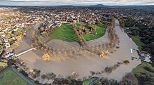
Further floods affected the United Kingdom from late September into October after the country saw heavy rains. On 22 September, part of the A421 road in Bedfordshire was closed between the M1 motorway and the A6 road it flooded significantly near Marston Moretaine; as of 5 October the road is still closed.[45] The River Wandle broke its banks for the first time since the 1960s, flooding AFC Wimbledon's stadium and leaving a sinkhole on the pitch.[46]
On 26 September, flash floods caused damage and disruption across the country, with flooding continuing into the following day. 35 people were evacuated from a caravan park in Yarwell, Northamptonshire, by firefighters after the area was flooded.[47] Several properties in Nuneaton were flooded and Bournville railway station was surrounded by water. In Wellington, Shropshire, severe flooding at the railway station forced the cancellation of all rail services between Shrewsbury and Wolverhampton and SEAH Stadium was flooded an hour before a match was due to be hosted. Flash flooding in All Stretton washed mud and stone into the village, flooded homes and forced a care home to evacuate after a wall collapsed. Travel disruptions included the cancellation of rail services between Birmingham and London Marylebone after flooding between Banbury and Bicester North; the closure of the M5 motorway between junctions 14 and 16 near Bristol after flooding left cars stranded;[48] and numerous other roads across the country being submerged. Residents in Abingdon, Oxfordshire, had to be evacuated after the River Ock burst its banks, with similar scenes in Bedfordshire around the Great River Ouse.[49]
In early December, Storm Darragh brought flooding to parts of Wales and western England. Heavy rain caused saturated ground and rising rivers, prompting flood warnings across southern Wales. Natural Resources Wales advised residents to avoid seafronts and low-lying areas. Properties and infrastructure suffered damage, including Llandudno Pier, which lost some units due to the weather, including an ice cream vendor and 150-year-old unit. Many river across Wales and the West Midlands causing extensive damage to businesses and property. One of the areas worst affected by heavy rainfall is Builth Wells.[57]
This page is based on this Wikipedia article Text is available under the CC BY-SA 4.0 license; additional terms may apply. Images, videos and audio are available under their respective licenses.