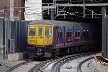
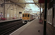
Farringdon ![]() ![]() ![]() | |
---|---|
The new National Rail entrance, built as part of the Thameslink Programme. It is built opposite the 1922 station frontage, which still stands. | |
Location | Clerkenwell |
Local authority | London Borough of Islington |
Managed by | London Underground |
Owner | Transport for London Network Rail |
Station code | ZFD |
DfT category | E |
Number of platforms | 6 (2 National Rail) (2 London Underground) (2 Elizabeth line) |
Accessible | Yes [1] [2] |
Fare zone | 1 |
London Underground annual entry and exit | |
2017 | ![]() |
2018 | ![]() |
2019 | ![]() |
2020 | ![]() |
2021 | ![]() |
National Rail annual entry and exit | |
2017–18 | ![]() |
– interchange | ![]() |
2018–19 | ![]() |
– interchange | ![]() |
2019–20 | ![]() |
– interchange | ![]() |
2020–21 | ![]() |
– interchange | ![]() |
2021–22 | ![]() |
– interchange | ![]() |
Key dates | |
10 January 1863 | Opened as Farringdon Street |
23 December 1865 | Resited |
26 January 1922 | Renamed Farringdon & High Holborn |
21 April 1936 | Renamed Farringdon |
1 July 1936 | Goods yard closed [9] |
1982 | Electrified |
May 1988 | Thameslink started |
21 March 2009 | Thameslink services to Moorgate discontinued |
24 May 2022 | Elizabeth line opened |
Listed status | |
Listed feature | Underground station |
Listing grade | II |
Entry number | 1298047 [10] |
Added to list | 17 May 1994 |
Other information | |
External links | |
WGS84 | 51°31′14″N00°06′18″W / 51.52056°N 0.10500°W Coordinates: 51°31′14″N00°06′18″W / 51.52056°N 0.10500°W |
![]() |
Farringdon is a London Underground and connected main line National Rail station in Clerkenwell, central London. The station is in the London Borough of Islington, just outside the boundary of the City of London. Opened in 1863 as the terminus of the Metropolitan Railway, the world's first underground passenger railway, Farringdon is one of the oldest surviving underground railway stations in the world.
Today the station is served by the London Underground Circle, Hammersmith & City, and Metropolitan lines between King's Cross St Pancras and Barbican, the National Rail Thameslink route between St Pancras and City Thameslink, and the TfL Elizabeth line (since the opening of the line between Abbey Wood and Paddington on 24 May 2022).
The station was opened on 10 January 1863 as the terminus of the original Metropolitan Railway, the world's first underground metro line. The station, initially named Farringdon Street, was originally a short distance from the present station building. The line ran from the Farringdon area to Paddington, a distance of 4 mi (6 km).
The station was relocated on 23 December 1865 when the Metropolitan Railway opened an extension to Moorgate. It was renamed Farringdon & High Holborn on 26 January 1922 when the new building by the architect Charles Walter Clark [10] facing Cowcross Street was opened, and its present name was adopted on 21 April 1936. [11] It was built in conjunction with a freight station to take livestock to a slaughterhouse to its south-east to supply Smithfield Market; remains of cattle ramps on a street outside the market, West Smithfield. Smithfield was redesignated as a wholesale 'deadmeat' market in the 19th century and the freight station was last used in the 1920s.
The lines from Farringdon towards King's Cross St. Pancras run alongside the Fleet ditch, culverted since 1734. [12] The station building is unusually well-preserved early 20th-century London Underground architecture. It retains indications of the Metropolitan Railway's main-line style operation such as a sign for a parcel office on the outer wall and some original signage, with the 1922–1936 name on the facade.
After the bay platforms at Blackfriars closed on 21 March 2009, Southeastern services that previously terminated at Blackfriars were extended to Kentish Town, St. Albans, Luton or Bedford, calling at this station. [13] Thameslink trains to Moorgate ceased at the same time.
There are two major rail development projects in progress that involve Farringdon: The Thameslink Programme is a major upgrade to the existing north-south Thameslink route, enabling longer and more frequent trains, completed in 2018; and the Four Lines Modernisation involves the wholesale resignalling of the London Underground's sub-surface lines bringing a major boost in capacity to Circle, Hammersmith & City and Metropolitan line services calling at Farringdon. [14]
Once these projects have been completed by 2023, Farringdon will be one of the country's busiest stations with approximately 200 tph, an average of one departure every 20 seconds. [15] A new building, housing a dedicated ticket hall, has been constructed to serve these extra passengers. The new building is to the immediate south of the original station, which itself has been upgraded as part of the programme.
An additional entrance has also been built at the north end of the original station, onto Turnmill Street.
Farringdon Station has been rebuilt [16] to accommodate longer Thameslink trains and to make other improvements to the station. [17] The existing station building has been refurbished with a new roof canopy covering the north end of all four platforms and a new entrance and concourse facing Turnmill Street. An additional ticket hall has been built on the south side of Cowcross Street providing access to the Thameslink platforms, which have been extended southwards underneath this building, allowing the station to handle 240 m (12-carriage) trains. Platforms have been widened to accommodate increased passenger numbers. This process required the bridge that formed Cowcross Street to be demolished and rebuilt. [18] Cowcross Street is now pedestrianised. [19] Lifts have been provided throughout.
The existing listed ticket hall and concourse have been remodelled, for use by London Underground and Thameslink passengers. [20] Interchange within the station has been improved by removing the interchange bridge and installing new stairs and lifts with access to all four platforms, allowing passengers with impaired mobility to use the station. [21]
It was necessary to build the Thameslink platform extensions to the south, since there is a sharp gradient to the immediate north of the station. This resulted in the two-station branch to Moorgate being permanently closed. [22] The platform extensions cross the former Moorgate line and reach within a few metres of the entrance of the Snow Hill Tunnel. [23] The alternative of realigning both the Thameslink and Circle/Hammersmith & City/Metropolitan lines was impractical as the latter crosses over the former on a bridge almost immediately to the north of the station. [23]
The Farringdon Elizabeth line station was built as part of the Crossrail project. It lies between Farringdon and Barbican Underground stations and has interchanges with both of them. [24] Access at the Farringdon end is via the new Thameslink ticket hall. [25] Work was anticipated to be completed in 2018, [26] but the scheduled opening date was delayed. [27]
From 24 May 2022 the new railway line linked Farringdon to Abbey Wood via Canary Wharf in the east and Paddington, in the west. The station is also a hub for cross-London travel, being the only station to be on both the north-south Thameslink service and the east-west Elizabeth line service. [25]
Direct Elizabeth line services between Reading/Heathrow in the west and Shenfield (via Whitechapel and Stratford) in the east is planned to commence in late 2022. [28]
Thameslink trains switch between the 25 kV AC overhead supply used to the north of London and the 750 V DC third rail supply used to the south whilst standing at the platform. The trains that formerly ran to Moorgate used 25 kV AC throughout their journeys. This project was installed by the Network SouthEast sector of British Rail in May 1988.
Until the start of the Thameslink Programme southbound trains that were unable to switch to DC were taken out of service at Farringdon and stabled at Moorgate to prevent them from blocking the core section of the Thameslink route. As this option is no longer possible the catenary has been extended to City Thameslink to enable these trains to continue to the southbound platform [29] at City Thameslink using AC and then return northwards using the new crossover in Snow Hill Tunnel. [30] The pantograph on southbound trains is normally lowered at Farringdon.
Underground trains serving Farringdon use the four-rail 630 V DC system.
The London Underground part of the station is directly next to the National Rail platforms and is served by the Metropolitan, Hammersmith & City and Circle lines, between King's Cross St Pancras and Barbican. All three lines share the same pair of tracks from Baker Street Junction to Aldgate Junction making this section of track one of the most intensely used on the London Underground network.
The typical service in trains per hour (tph) is: [37]
The Metropolitan line is the only line to operate express services, though currently (when?) this is only during peak times (Westbound 06:30–09:30 / Eastbound 16:00–19:00). Fast services run non-stop between Wembley Park, Harrow-on-the-Hill and Moor Park. Semi-fast services run non-stop between Wembley Park and Harrow-on-the-Hill. [38]
The typical off-peak service in trains per hour (tph) is: [39]
Off-peak services to/from Watford terminate at Baker Street
The typical peak time service in trains per hour (tph) is: [39]
Farringdon is in Transport for London's Travelcard Zone 1.
All National Rail services at Farringdon are served by Thameslink trains between St Pancras International and City Thameslink using part of the City Widened Lines and Snow Hill Tunnel respectively. Services are operated using Class 700 EMUs.
The typical off-peak service in trains per hour is: [40]
The station is also served by a half-hourly night service between Bedford and Three Bridges. [41]
Prior to 2009, Thameslink services also ran to Moorgate via Barbican with trains diverging from the core route east of the platforms at Farringdon. This section of line was closed as part of the Thameslink Programme which involved the construction of a new ticket hall and the lengthening of platforms at Farringdon to enable platform extensions to accommodate longer 12 carriage trains which covered over the junction in the process.
Farringdon is in Transport for London's Travelcard Zone 1.
Elizabeth line services began calling at Farringdon on 24 May 2022 and all services are operated using Class 345 EMUs.
The typical off-peak service in trains per hour is: [42]
These services combine to give a service of 16 tph in each direction. During the peak hours, the service is increased to 20 tph in each direction.
On Sundays, the services between Shenfield and London Paddington are reduced to 4 tph, with another 4 tph terminating instead at Gidea Park.
London Buses routes 40, 63, 341 and night route N63 serve the station. [43]
Thameslink is a 24-hour main-line route in the British railway system, running from Bedford, Luton, St Albans City, Peterborough and Cambridge via central London to Sutton, Orpington, Sevenoaks, Rainham, Horsham, Brighton, East Grinstead, and Littlehampton. The network opened as a through service in 1988, with severe overcrowding by 1998, carrying more than 28,000 passengers in the morning peak. All the services are currently operated by Govia Thameslink Railway.
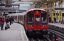
The Circle line is a spiral-shaped London Underground line, running from Hammersmith in the west to Edgware Road and then looping around central London back to Edgware Road. The railway is below ground in the central section and on the loop east of Paddington. Unlike London's deep-level lines, the Circle line tunnels are just below the surface and are of similar size to those on British main lines. Printed in yellow on the Tube map, the 17-mile (27 km) line serves 36 stations, including most of London's main line termini. Almost all of the route, and all the stations, are shared with one or more of the three other sub-surface lines, namely the District, Hammersmith & City and Metropolitan lines. On the Circle and Hammersmith & City lines combined, over 114 million passenger journeys were recorded in 2011/12.
The Hammersmith & City line is a London Underground line that runs between Hammersmith in west London and Barking in east London. Printed in pink on the Tube map, it serves 29 stations over 15.8 miles (25.5 km). Between Farringdon and Aldgate East it skirts the City of London, the capital's financial heart, hence the line's name. Its tunnels are just below the surface and are a similar size to those on British main lines. Most of the track and all stations are shared with either the District, Circle, or Metropolitan lines. Over 114 million passenger journeys are made each year on the Hammersmith & City and Circle lines.
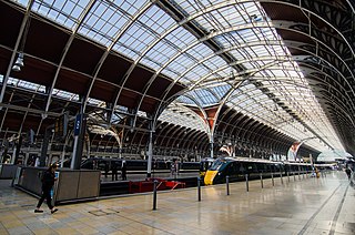
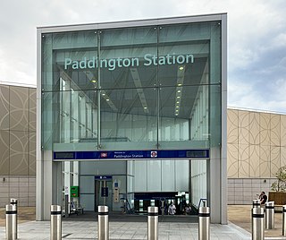
Paddington, also known as London Paddington, is a Central London railway terminus and London Underground station complex, located on Praed Street in the Paddington area. The site has been the London terminus of services provided by the Great Western Railway and its successors since 1838. Much of the main line station dates from 1854 and was designed by Isambard Kingdom Brunel.
Baker Street is a London Underground station at the junction of Baker Street and the Marylebone Road in the City of Westminster. It is one of the original stations of the Metropolitan Railway (MR), the world's first underground railway, opened on 10 January 1863.
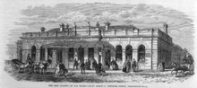
King's Cross Thameslink station is a closed railway station in central London, England. It is located on Pentonville Road, around 250 metres (0.2 mi) east of King's Cross mainline station. At the time of closure, in 2007, it was served by Thameslink trains and managed by First Capital Connect.
Moorgate is a central London railway terminus and connected London Underground station on Moorgate in the City of London. Main line railway services for Hertford, Welwyn Garden City and Stevenage are operated by Great Northern, while the Underground station is served by the Circle, Hammersmith & City, Metropolitan and Northern lines.
West Ham is a London Underground, Docklands Light Railway (DLR) and National Rail intermodal interchange station in West Ham, London, United Kingdom. The station is served by London Underground's District, Hammersmith & City and Jubilee lines, the Stratford International branch of the DLR, and c2c National Rail services.
Edgware Road is a London Underground station on the Circle, District and Hammersmith & City lines, located on the corner of Chapel Street and Cabbell Street, within Travelcard zone 1. A separate station of the same name but served by the Bakerloo line is located about 150 metres away on the opposite side of Marylebone Road.
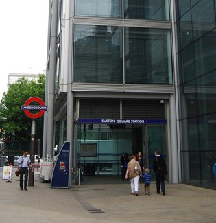
Euston Square is a London Underground station at the corner of Euston Road and Gower Street, just north of University College London – its main entrance faces the tower of University College Hospital. The multi-interchange Euston station is beyond Euston Square Gardens, which is one street east. The station is between Great Portland Street and King's Cross St Pancras on the Circle, Hammersmith & City and Metropolitan lines in Travelcard Zone 1.
Aldgate is a London Underground station near Aldgate in the City of London. The station is on the Circle line between Tower Hill and Liverpool Street, and is the eastern terminus of the Metropolitan line. It is in Travelcard Zone 1.
Whitechapel is an interchange station in Whitechapel, East London for London Underground, London Overground and Elizabeth line services. The station is located behind a street market of the same name and opposite Tower Hamlets Town Hall. It lies between Aldgate East and Stepney Green stations on the District and Hammersmith & City lines, between Shoreditch High Street and Shadwell stations on the East London Line. To the West of Whitechapel on the Elizabeth Line is Liverpool Street, to the East the line splits with one branch going to Stratford and one to Canary Wharf. It is in Travelcard Zone 2.
Great Portland Street is a London Underground station near Regent's Park. It is between Baker Street and Euston Square on the Hammersmith & City, Circle and Metropolitan lines. Great Portland Street station is listed as a building of National Significance and lies in Travelcard Zone 1.
Barbican is a London Underground station situated near the Barbican Estate, on the edge of the ward of Farringdon Within, in the City of London in Central London. It has been known by various names since its opening in 1865, mostly in reference to the neighbouring ward of Aldersgate.
Stepney Green is a London Underground station located on Mile End Road in Stepney, London, United Kingdom. It is between Whitechapel and Mile End on the District line and the Hammersmith & City line, and is in Travelcard Zone 2.
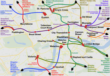
The London station group is a group of 18 railway stations served by the National Rail network in central London. The group contains all 14 terminal stations in central London, either serving major national services or local commuter routes, and 4 other through-stations that are considered terminals for ticketing purposes. All current stations in the group fall within London fare zone 1. A ticket marked "London Terminals" allows travel to any station in the group via any permitted route, as determined by the National Routeing Guide.
The Thameslink Programme, originally Thameslink 2000, was a £6 billion project in south-east England to upgrade and expand the Thameslink rail network to provide new and longer trains between a wider range of stations to the north and to the south of London. The development facilitated new cross-London journeys, which means that passengers no longer have to change trains in London. Work included platform lengthening, station remodelling, new railway infrastructure, and new rolling stock. The project was originally proposed in 1991 following the successful introduction of the initial Thameslink service in 1988. After many delays, planning permission was granted in 2006 and funding was approved in October 2007. Work started in 2009 and was completed on 18 September 2020, although trains over the new routes began running in 2018.
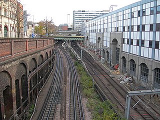
The Widened Lines is a double-track railway line forming part of the Thameslink route between St Pancras and Farringdon within Central London.
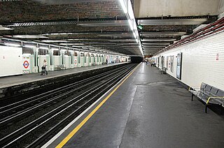
Paddington is a London Underground station served by the Circle and Hammersmith & City lines. It is located adjacent to the north side of Paddington mainline station and has entrances from within the mainline station and from Paddington Basin. The station is between Royal Oak and Edgware Road and is in London Fare Zone 1.
Paddington is a London Underground station served by the Bakerloo, Circle and District lines. It is located on Praed Street to the south of Paddington mainline station and has entrances from Praed Street and from within the mainline station. On the Bakerloo line the station is between Warwick Avenue and Edgware Road and on the Circle and District lines it is between Bayswater and Edgware Road. It is in London Fare Zone 1.
See page 15, paragraph 2.2.1