Cassiobridge tube station

Last updated

Cassiobridge Underground no-text.svg
Watford, Ascot Road railway bridge - geograph.org.uk - 735534.jpg
Ascot Road railway bridge
Hertfordshire UK location map.svg
Red pog.svg
Cassiobridge
Location of Cassiobridge in Hertfordshire
Location Watford
Local authority Watford Borough Council
Managed by London Underground
Number of platforms2
London Underground annual entry and exit
2018Not opened [1]
2019Not opened [2]
2020Not opened [3]
2021Not opened [4]
2022Not opened [5]
Key dates
2020 [6] Planned opening
Other information
WGS84 51°39′04″N0°25′27″W / 51.650993°N 0.424283°W / 51.650993; -0.424283
Underground sign at Westminster.jpg  London transportportal

Cassiobridge was a proposed London Underground station in Watford, Hertfordshire, England. The station would have been part of the Croxley Rail Link project, a scheme to extend the Metropolitan line to Watford Junction railway station. It would have been served by Metropolitan line trains between Watford Junction and Central London via Baker Street. [7] The railway line would run over Ascot Road via a viaduct and the platforms would have been situated on the east side of the road. Entrance to the station would have been from the west side of the road, with a ticket hall and other facilities at street level. Passengers would gain access to the platforms via stairs and lifts and a short footbridge over the road. [8]

Contents

The station is projected to offer interchange with local transport services, [9] and operate as an unstaffed station, providing automatic ticketing facilities similar to a DLR station. There is potential for Park and Ride facilities to be provided, although planning documents indicate high levels of congestion on adjacent roads. [10] Watford station would close to passenger services, so that all trains from Croxley would continue to Watford Junction.

The railway and station had been expected to come into service in 2020 [6] [7] but on 25 January 2017, the Watford Observer newspaper published an update on the Croxley Rail Link confirming that work had stopped as there was an ongoing funding issue. [11]

Station name

Originally the station was to be called Ascot Road but some local people and councillors considered that this name would not reflect the identity of the area. Transport planners also expressed concern that the new tube station could be too easily confused with Ascot station in Berkshire. After some consultation on the names of the two new stations on the line, it was decided in August 2013 to use the name Cassiobridge instead, while the planned Watford Hospital station was changed to Watford Vicarage Road to be more recognisable outside the area. [12] [13]

Cassiobridge as a name has some historical provenance. There was a Cassiobridge Farm close to a bridge over the River Gade and nearby there is an early 19th-century timber house called Cassiobridge Lodge. These properties are linked with the former stately home of Cassiobury House and its estate, now the public Cassiobury Park, and the surrounding suburb of Cassiobury. [14] [15] The two modern bridges in the area now carry the A412 road over the Grand Union Canal and the River Gade. [13]

Cassiobridge and the Croxley Rail Link
Watford Cassiobury map 1920.png
1920 OS map of Watford showing Cassio Bridge at the bottom left corner
Croxley rail link map.png
Map of the Croxley Rail Link via Cassiobridge

Related Research Articles

<span class="mw-page-title-main">Watford</span> Town and borough in Hertfordshire, England

Watford is a town and borough in Hertfordshire, England, 15 mi (24 km) north-west of Central London, on the banks of the River Colne.

<span class="mw-page-title-main">Watford tube station</span> London Underground station

Watford tube station is the terminus of a Metropolitan line branch line in the north-western part of the London Underground in Zone 7. The station opened in 1925.

<span class="mw-page-title-main">Queen's Park station (England)</span> London Underground and London Overground station

Queen's Park is an interchange station on the Watford DC line and Bakerloo line served by London Overground and London Underground respectively. It lies at the southern end of Salusbury Road, near the south-east corner of the public park from which the area now known as Queen's Park has taken its modern name. The station is in Travelcard Zone 2.

<span class="mw-page-title-main">Kensal Green station</span> London Underground and London Overground station

Kensal Green is a railway station served by London Underground Bakerloo line and London Overground trains. It is located in College Road, London NW10 close to the junction with Harrow Road. It is about 0.5 mile (750m) route distance from the older Kensal Rise station located to the north east on the North London line, which was itself named Kensal Green until 1890. The station is in a cutting with a tunnel at the western end.

<span class="mw-page-title-main">Harlesden station</span> London Underground and London Overground station

Harlesden is a Network Rail station on Acton Lane in northwest London, served by London Overground and by London Underground Bakerloo line trains. The railway line here is the border between the Harlesden and Stonebridge residential area in the east, and the Park Royal industrial estate to the west. The southern end of Willesden Brent Sidings separates the station from the West Coast Main Line.

<span class="mw-page-title-main">Stonebridge Park station</span> London Underground and London Overground station

Stonebridge Park is a London Overground and London Underground station in Tokyngton and Stonebridge, north-west London. It is on both the London Overground Watford DC line and London Underground Bakerloo line. It is located on Argenta Way, and is named after the nearby junction connecting the North Circular Road (A406) with the Harrow Road (A404).

<span class="mw-page-title-main">North Wembley station</span> London Underground and London Overground station

North Wembley is a railway station on the Watford DC line and Bakerloo line in North Wembley, north-west London. The station is served by London Overground and London Underground services. It is between South Kenton to the north, and Wembley Central to the south and located on the south side of East Lane, part of the London Borough of Brent, serving residents of North Wembley and western parts of Wembley Park.

<span class="mw-page-title-main">South Kenton station</span> London Underground and railway station

South Kenton is a station in Kenton, north-west London. The station is served by suburban services operated by London Underground on the Bakerloo line and London Overground on the Watford DC line. In the Bakerloo line, the station lies between Kenton and North Wembley stations. It is located between The Link in the Sudbury Court Estate of North Wembley, and Windermere Grove in Kenton, in the Wembley postal area.

<span class="mw-page-title-main">Kenton station</span> London Underground and railway station

Kenton is a railway station on the Watford DC line and the London Underground Bakerloo line, situated on Kenton Road in Kenton, north-west London. The station is served by London Overground and London Underground services. It has an out of station interchange (OSI) with Northwick Park station on the London Underground's Metropolitan line. In the Bakerloo line, the station is between Harrow & Wealdstone and South Kenton stations.

<span class="mw-page-title-main">Watford Junction railway station</span> Railway station that serves Watford, Hertfordshire

Watford Junction is a railway station that serves Watford, Hertfordshire. The station is on the West Coast Main Line (WCML), 17 miles 34 chains from London Euston and the Abbey Line, a branch line to St Albans. Journeys to London take between 16 and 52 minutes depending on the service used: shorter times on fast non-stop trains and slower on the stopping Watford DC line services. Trains also run to Clapham Junction and East Croydon via the West London Line. The station is a major hub for local bus services and the connecting station for buses to Warner Bros. Studio Tour London – The Making of Harry Potter. The station is located north of a viaduct over the Colne valley and immediately south of Watford Tunnel.

<span class="mw-page-title-main">Cassiobury</span> Human settlement in England

The Cassiobury Estate is a suburban residential area of Watford in Hertfordshire, England. It is bounded to the south by Cassiobury Park, the main public park in the town, to the west by playing fields next to the River Gade, and to the northeast by Hempstead Road. It is mostly characterised by 1930s Mock Tudor houses.

<span class="mw-page-title-main">West Brompton station</span> London Underground, London Overground and National Rail station

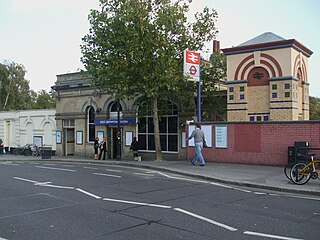
West Brompton is a London Underground, London Overground and National Rail station on Old Brompton Road (A3218) in West Brompton, located in west London, and is on the District line and West London Line (WLL). It is immediately south of the demolished Earls Court Exhibition Centre and west of Brompton Cemetery in the Royal Borough of Kensington and Chelsea.

<span class="mw-page-title-main">Croxley tube station</span> London Underground station

Croxley is a London Underground station located on Watford Road (A412) in Croxley Green, Rickmansworth, Hertfordshire, on the Watford branch of the Metropolitan line. It is the only intermediate station on the branch between Moor Park, on the main line from Baker Street to Amersham, and the terminus at Watford.

<span class="mw-page-title-main">Moor Park tube station</span> London Underground station

Moor Park is a London Underground station in the Three Rivers district of Hertfordshire, serving those living on the Moor Park estate, and also on the neighbouring Eastbury and South Oxhey estates. The station is outside the Greater London boundary but is in both Zone 6 and Zone 7, between the Metropolitan line stations of Rickmansworth, Croxley and Northwood.

<span class="mw-page-title-main">Watford Stadium Halt railway station</span> Railway stop in Hertfordshire, England

Watford Stadium Halt railway station was a railway station in Watford, Hertfordshire, United Kingdom on the branch line from Watford Junction to Croxley Green. It served Vicarage Road stadium, home of Watford F.C., and was open only on match days.

<span class="mw-page-title-main">Watford High Street railway station</span> London Overground station

Watford High Street is a railway station in Watford, Hertfordshire, United Kingdom. It is served by the Watford DC line on the London Overground network. It is the only station on the line's sole deviation from the West Coast Main Line.

<span class="mw-page-title-main">Watford and Rickmansworth Railway</span>

The Watford and Rickmansworth Railway (W&RR) ran services between Watford and Rickmansworth in Hertfordshire, England. The company was incorporated in 1860; the line opened in 1862. The Rickmansworth branch was closed in 1952, and the remaining line was gradually run down and eventually closed in 1996.

<span class="mw-page-title-main">Croxley Rail Link</span> Proposed railway project in England

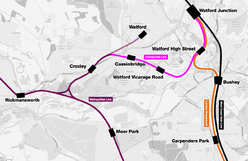
The Croxley Rail Link, or the Metropolitan Line Extension, is a proposed railway engineering project in the Watford and Three Rivers districts of Hertfordshire, England, that would have connected the London Overground and the London Underground's Metropolitan line at Watford Junction. If the link were to go ahead, the Metropolitan line's terminus at Watford Underground station would be closed and the line diverted and extended from Croxley to Watford Junction via a reopened section of closed line. The main proponent of the scheme has been Hertfordshire County Council but it failed to win the support of Transport for London (TfL) which owns the Watford branch. The engineering works would have consisted of the realignment of the disused Watford and Rickmansworth Railway's line between Croxley Green and Watford High Street, with the construction of a viaduct over the Grand Union Canal, River Gade and A412 road and two new stations before branching into the London Overground line near Watford High Street and continuing to Watford Junction.

<span class="mw-page-title-main">Watford Vicarage Road tube station</span> Planned London Underground station

Watford Vicarage Road was a proposed London Underground station in Watford, Hertfordshire. The station was proposed to be part of the suspended Croxley Rail Link project, a scheme to extend the Metropolitan line to Watford Junction railway station, which would've been served by Metropolitan line trains between Watford Junction and Central London via Baker Street. Originally the station was to be named either Watford Hospital or Watford General Hospital. On 25 January 2017, the Watford Observer newspaper published an update on the Croxley Rail Link confirming work had stopped as there was an ongoing funding issue.

<span class="mw-page-title-main">Watford Central tube station</span> Unbuilt London Underground station

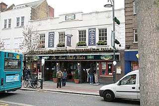
Watford Central, a planned London Underground station in the centre of Watford, Hertfordshire, was to be the terminus of a proposed extension of the Metropolitan line from the present-day Watford tube station to the High Street opposite Clarendon Road. The proposed station booking hall has long gone, however, the facade was retained and a new building constructed behind it. It is now The Moon Under Water public house.

References

  1. "Station Usage Data" (CSV). Usage Statistics for London Stations, 2018. Transport for London. 23 September 2020. Archived from the original on 14 January 2023. Retrieved 11 October 2023.
  2. "Station Usage Data" (XLSX). Usage Statistics for London Stations, 2019. Transport for London. 23 September 2020. Archived from the original on 9 November 2020. Retrieved 9 November 2020.
  3. "Station Usage Data" (XLSX). Usage Statistics for London Stations, 2020. Transport for London. 16 April 2021. Retrieved 1 January 2022.
  4. "Station Usage Data" (XLSX). Usage Statistics for London Stations, 2021. Transport for London. 12 July 2022. Retrieved 7 September 2022.
  5. "Station Usage Data" (XLSX). Usage Statistics for London Stations, 2022. Transport for London. 4 October 2023. Retrieved 10 October 2023.
  6. 1 2 "Metropolitan Line Extension". Transport For London - Improvements & projects. Archived from the original on 17 July 2017. Retrieved 9 January 2016.
  7. 1 2 "TWAO Submission January 2012". Croxley Rail Link. 6 January 2012. Archived from the original on 12 February 2012.
  8. "Cassiobridge Station Ascot Road" (PDF). Hertfordshire County Council Development Management Section Head. Archived from the original (PDF) on 6 January 2015. Retrieved 6 January 2015.
  9. "Watford Vision, Principles, Aims and Strategy - Chapter 4: Movement". Watford Borough Council. Archived from the original (PDF) on 8 December 2014. Retrieved 6 January 2015.
  10. "DfT Expression of Interest - Submission for Funding" (PDF). Archived from the original (PDF) on 1 June 2011.
  11. "UPDATE: Met Line extension: Mayor confirms work has stopped". 25 January 2017. Archived from the original on 31 March 2017. Retrieved 29 May 2017.
  12. Wright, Mike (7 June 2013). "Names in the frame for new Croxley Rail Link stations in Watford". Watford Observer . Archived from the original on 7 June 2013.
  13. 1 2 Wright, Mike (22 July 2013). "Croxley Rail Link: Politicians lobby TFL over West Watford station name". Watford Observer . Archived from the original on 5 August 2013.
  14. Rabbitts, Paul; Priestley, Sarah (2014). Cassiobury: The Ancient Seat of the Earls (Google eBook). Amberley Publishing Limited. ISBN   9781445638805. Archived from the original on 8 December 2015. Retrieved 31 October 2014.
  15. "Cassio Bridge Lodge, Watford". British Listed Buildings. Archived from the original on 8 December 2015. Retrieved 5 January 2015.
Abandoned Croxley Rail Link plan
Preceding station Underground no-text.svg London Underground Following station
Watford Vicarage Road Metropolitan line
Croxley Rail link
Croxley
towards Baker Street or Aldgate