Aldgate tube station

Last updated

Aldgate Underground no-text.svg
Aldgate station front 2020.jpg
Station entrance
Open street map central london.svg
Red pog.svg
Aldgate
Location of Aldgate in Central London
Location Portsoken
Local authority City of London
Managed by London Underground
Number of platforms4
Fare zone 1
OSI Aldgate East Underground no-text.svg Fenchurch Street National Rail logo.svg Tower Gateway DLR no-text roundel.svg [1]
London Underground annual entry and exit
2018Decrease2.svg 8.47 million [2]
2019Increase2.svg 9.96 million [3]
2020Decrease2.svg 2.78 million [4]
2021Increase2.svg 3.53 million [5]
2022Increase2.svg 6.90 million [6]
Key dates
18 November 1876 (18 November 1876)Opened
Other information
External links
WGS84 51°30′50″N0°04′34″W / 51.514°N 0.076°W / 51.514; -0.076
Underground sign at Westminster.jpg  London transportportal

Aldgate is a London Underground station near Aldgate in the City of London. The station is on the Circle line between Tower Hill and Liverpool Street, and is the eastern terminus of the Metropolitan line. It is in Travelcard Zone 1. [7]

Contents

Aldgate was opened in 1876 with its entrance on Aldgate High Street. A station named Aldgate East opened nearby eight years later [8] and is served today by the District and Hammersmith & City lines. [7]

History

The route first proposed ran south from Moorgate to Cannon Street, but this was soon amended to the present alignment to allow connection with three additional termini: Liverpool Street, Broad Street, and Fenchurch Street. [9] However, this change also forced an awkward doubling-back at Aldgate, reducing the desirability of the line for local traffic and greatly increasing the cost of construction due to high prices in the City of London. [9] Construction was also delayed because the station was on the site of a plague pit behind St Botolph's Aldgate which contains an estimated 1,000 bodies. [10] [11] [12]

Aldgate station was opened on 18 November 1876, with a southbound extension to Tower Hill opening on 25 September 1882, completing the Circle (line). [9] Services from Aldgate originally ran further west than they do now, reaching as far as Richmond.

The train shed of 1876 survives, hidden from the street by the later station frontage building erected in 1926. This was designed by Charles Walter Clark the Metropolitan Railway's chief architect between 1911 and 1933. [n 1]

The station building has a six-bay façade clad in white faïence with original features including 1920s shopfronts with green marble and pink granite stallrisers, a half-hexagonal canopy of glass and metal suspended by elegant metal ties, leaded light first floor windows, dentil cornice, two ornamental lamp brackets and a frieze bearing moulded lettering and the Metropolitan Railway monogram.

Aldgate became the terminus of the Metropolitan line in 1941. Before that, Metropolitan trains had continued on to the southern termini of the East London Line.

In 2005, one of four suicide bombers involved in the 7 July terrorist attacks detonated a device on a C-stock Circle line train from Liverpool Street as it was approaching Aldgate. [13] Seven passengers were killed in the bombing. [13] Of the stations affected by the bombings, Aldgate was the first to be reopened, once police had handed back control of the site to London Underground following an extensive search for evidence. After the damaged tunnel was repaired by Metronet engineers, the lines were reopened. This allowed the Metropolitan line to be fully restored, since the closure had meant all trains had to be terminated two stations early, at Moorgate. [14]

Services

On the Circle line the typical off-peak service measured in trains per hour (tph) is:

On the Metropolitan line the typical off-peak service in trains per hour is:

During peak hours there are also additional fast and semi-fast Metropolitan line services, with some following the route to and from Watford. [14]

Connections

London Buses day and night routes serve the station. [18] [19]

Cultural references

Aldgate station plays a role in the Sherlock Holmes story The Adventure of the Bruce-Partington Plans (published in the anthology His Last Bow ).

In the story, the body of a junior clerk named Cadogan West is found on the tracks outside Aldgate, with a number of stolen plans for the Bruce-Partington submarine in his pocket. It seems clear enough that "the man, dead or alive, either fell or was precipitated from a train." But why, wonders Holmes, did the dead man not have a ticket? It turns out that the body was placed on top of a train carriage before it reached Aldgate, via a window in a house on a cutting overlooking the Metropolitan line. Holmes realises that the body fell off the carriage roof only when the train was jolted by the dense concentration of points at Aldgate.

Aldgate is also mentioned in John Creasey's 1955 detective novel Gideon's Day . It has also appeared in two films: Four in the Morning (1965) starring Ann Lynn and Norman Rodway and V for Vendetta (2006), starring Hugo Weaving and Natalie Portman.

Notes and references

Notes

  1. Clark designed other station buildings for the Metropolitan Railway in this period to a similar design faced in the same white faïence such as Farringdon (1922 – Grade II listed), Edgware Road (1928) and Willesden Green (1925 – Grade II listed), the Grade II* listed Baker Street station and the Chiltern Court apartment building that rises above it (completed in 1929). He also designed outer suburban stations on the line to Stanmore (1932).

Related Research Articles

<span class="mw-page-title-main">Baker Street tube station</span> London Underground station

Baker Street is a London Underground station at the junction of Baker Street and the Marylebone Road in the City of Westminster. It is one of the original stations of the Metropolitan Railway (MR), the world's first underground railway, opened on 10 January 1863.

<span class="mw-page-title-main">Bayswater tube station</span> London Underground station

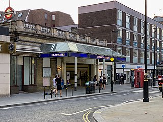
Bayswater is a London Underground station in the Bayswater area of the City of Westminster. The station is on the Circle and District lines, between Notting Hill Gate and Paddington stations and is in Travelcard Zone 1. It is less than 100 metres (330 ft) away from the Central line's Queensway station.

<span class="mw-page-title-main">Moorgate station</span> London Underground and railway station

Moorgate is a central London railway terminus and connected London Underground station on Moorgate in the City of London. Main line railway services for Hertford, Welwyn Garden City and Stevenage are operated by Great Northern, while the Underground station is served by the Circle, Hammersmith & City, Metropolitan and Northern lines.

<span class="mw-page-title-main">Farringdon station</span> National rail and London Underground station

Farringdon is an interchange station located in Clerkenwell, London, England, in the London Borough of Islington, just outside the boundary of the City of London for London Underground, Elizabeth line and National Rail services.

<span class="mw-page-title-main">Tower Hill tube station</span> London Underground station

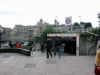
Tower Hill is a London Underground station in Tower Hill in the East End of London. It is on the Circle line between Monument and Aldgate stations, and the District line between Monument and Aldgate East. Tower Hill is within Travelcard zone 1 and is a short distance from Tower Gateway station for the Docklands Light Railway, Fenchurch Street station for National Rail mainline services, and Tower Millennium Pier for River Services.

<span class="mw-page-title-main">Aldgate East tube station</span> London Underground station

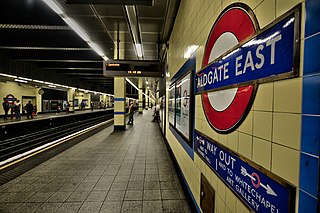
Aldgate East is a London Underground station on Whitechapel High Street in Whitechapel, in London, England. It takes its name from the City of London ward of Aldgate, the station lying to the east of the ward. It is on the Hammersmith & City line between Liverpool Street and Whitechapel, and on the District line between Tower Hill and Whitechapel, in Travelcard Zone 1.

<span class="mw-page-title-main">High Street Kensington tube station</span> London Underground station

High Street Kensington is a London Underground station on Kensington High Street, in Kensington. The station is on the Circle line between Gloucester Road and Notting Hill Gate, and the District line between Earl's Court and Notting Hill Gate and is in Travelcard Zone 1. Kensington Arcade forms the entrance to the station.

<span class="mw-page-title-main">Great Portland Street tube station</span> London Underground station

Great Portland Street is a London Underground station near Regent's Park. It is between Baker Street and Euston Square on the Hammersmith & City, Circle and Metropolitan lines. Great Portland Street station is listed as a building of National Significance and lies in Travelcard Zone 1.

<span class="mw-page-title-main">Barbican tube station</span> London Underground station

Barbican is a London Underground station situated near the Barbican Estate, on the edge of the ward of Farringdon Within, in the City of London in Central London. It has been known by various names since its opening in 1865, mostly in reference to the neighbouring ward of Aldersgate.

<span class="mw-page-title-main">Kentish Town station</span> London Underground and railway station

Kentish Town is an interchange station located in Kentish Town in the London Borough of Camden for London Underground and National Rail services.

<span class="mw-page-title-main">Chalfont & Latimer station</span> London Underground and railway station

Chalfont & Latimer is a London Underground and National Rail station in Travelcard Zone 8 on the Metropolitan line, in Buckinghamshire. It also serves the Chiltern Railways line to Aylesbury. Chalfont & Latimer station is located just before the junction for trains to Chesham. The station serves Chalfont St Giles, Chalfont St Peter, Little Chalfont and Latimer. It is located in Little Chalfont. It opened as "Chalfont Road" on 8 July 1889 but changed to the present name from 1 November 1915. The station is a good location to alight from to explore the Chess Valley.

<span class="mw-page-title-main">Upminster station</span> London Underground and railway station

Upminster is an interchange station serving the town of Upminster in the London Borough of Havering, Greater London. It is on the London, Tilbury and Southend line (LTSR), 15 miles 20 chains (24.5 km) down the line from London Fenchurch Street; it is the eastern terminus of the District line on the London Underground; and it is the eastern terminus of the Romford to Upminster Line on the London Overground network. Upminster is the easternmost station on the London Underground network as well as the easternmost National Rail station in London.

<span class="mw-page-title-main">Northwick Park tube station</span> London Underground station

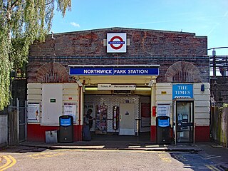
Northwick Park is a London Underground station in Kenton in the London Borough of Brent on the Metropolitan line. It lies between Harrow-on-the-Hill and Preston Road stations and is in Travelcard zone 4. The station takes its name from the nearby public park, Northwick Park.

<span class="mw-page-title-main">Burnt Oak tube station</span> London Underground station

Burnt Oak is a London Underground station in Burnt Oak, north London, on Watling Avenue, off the A5. The station is on the Edgware branch of the Northern line, between Edgware and Colindale stations, and is in Travelcard Zone 4.

<span class="mw-page-title-main">Chorleywood station</span> London Underground and railway station

Chorleywood is a London Underground and National Rail station in Travelcard Zone 7 on the Metropolitan line. The village of Chorleywood is in the Three Rivers district of Hertfordshire about 20 miles (32 km) from London. Chorleywood station is also served by Chiltern Railways, which runs trains from London Marylebone station through to Aylesbury.

<span class="mw-page-title-main">West Harrow tube station</span> London Underground station

West Harrow is a London Underground station in Harrow in north west London.

<span class="mw-page-title-main">Preston Road tube station</span> London Underground station

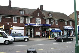
Preston Road is a London Underground station in Preston Road in the London Borough of Brent. It is on the Metropolitan line between Northwick Park and Wembley Park stations and is in Travelcard Zone 4. It serves the local area of Preston in Wembley and parts of Kenton.

<span class="mw-page-title-main">Hillingdon tube station</span> London Underground station

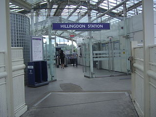
Hillingdon tube station is a London Underground station in North Hillingdon in the London Borough of Hillingdon, West London. Located between Uxbridge and Ickenham, it is in Travelcard Zone 6. It is the penultimate station on the Uxbridge branch of both the Metropolitan line and the Piccadilly line. Resited in 1992, it is also the most recently constructed station on the Metropolitan line.

<span class="mw-page-title-main">Paddington tube station (Circle and Hammersmith & City lines)</span> London Underground station

Paddington is a London Underground station served by the Circle and Hammersmith & City lines. It is located adjacent to the north side of Paddington mainline station and has entrances from within the mainline station and from Paddington Basin. The station is between Royal Oak and Edgware Road and is in London Fare Zone 1.

<span class="mw-page-title-main">Paddington tube station (Bakerloo, Circle and District lines)</span> London Underground station

Paddington is a London Underground station served by the Bakerloo, Circle and District lines. It is located on Praed Street to the south of Paddington mainline station and has entrances from Praed Street and from within the mainline station. On the Bakerloo line the station is between Warwick Avenue and Edgware Road and on the Circle and District lines it is between Bayswater and Edgware Road. It is in London Fare Zone 1.

References

  1. "Out-of-Station Interchanges" (Microsoft Excel). Transport for London. 2 January 2016. Retrieved 28 August 2016.
  2. "Station Usage Data" (CSV). Usage Statistics for London Stations, 2018. Transport for London. 23 September 2020. Archived from the original on 14 January 2023. Retrieved 11 October 2023.
  3. "Station Usage Data" (XLSX). Usage Statistics for London Stations, 2019. Transport for London. 23 September 2020. Archived from the original on 9 November 2020. Retrieved 9 November 2020.
  4. "Station Usage Data" (XLSX). Usage Statistics for London Stations, 2020. Transport for London. 16 April 2021. Retrieved 1 January 2022.
  5. "Station Usage Data" (XLSX). Usage Statistics for London Stations, 2021. Transport for London. 12 July 2022. Retrieved 7 September 2022.
  6. "Station Usage Data" (XLSX). Usage Statistics for London Stations, 2022. Transport for London. 4 October 2023. Retrieved 10 October 2023.
  7. 1 2 Standard Tube Map (PDF) (Map). Not to scale. Transport for London. November 2022. Archived (PDF) from the original on 7 November 2022. Retrieved 12 November 2022.
  8. Clive's Underground Line Guides – District line
  9. 1 2 3 4 5 Clive's Underground Line Guides – Circle line
  10. "London Plague Pit". The Boston Globe. 26 July 1920. p. 8 via Newspapers.com. Open Access logo PLoS transparent.svg
  11. Johnson, Ben. "The Reputed Plague Pits of London". Historic UK. Retrieved 29 August 2020.
  12. Harding, Vanessa (Spring 2001). "Burial of the Plague Dead in Early Modern London". History In Focus. Institute of Historical Research. Retrieved 29 August 2020.
  13. 1 2 Laville, Sandra; Aslam, Dilpazier (14 July 2005). "Trophy-rich athlete who turned to jihad". The Guardian. London. Archived from the original on 23 May 2010.
  14. 1 2 3 4 5 Clive's Underground Line Guides – Metropolitan line
  15. "Circle line timetable: From Aldgate Underground Station to Tower Hill Underground Station". Transport for London . Retrieved 28 March 2015.
  16. "Circle line timetable: From Aldgate Underground Station to Liverpool Street Underground Station". Transport for London . Retrieved 28 March 2015.
  17. 1 2 3 "Metropolitan line timetable: From Aldgate Underground Station to Liverpool Street Underground Station". Transport for London . Retrieved 28 March 2015.
  18. "Buses from Aldgate and Fenchurch Street" (PDF). TfL. July 2022. Retrieved 3 June 2021.
  19. "Night buses from Aldgate and Fenchurch Street" (PDF). TfL. March 2021. Retrieved 3 June 2021.
Preceding station Underground no-text.svg London Underground Following station
Liverpool Street Circle line
Tower Hill
towards Edgware Road via  Victoria
Liverpool Street Metropolitan line Terminus
Former services
Preceding station Underground no-text.svg London Underground Following station
Liverpool Street Circle line
(1884–1967)
Mark Lane
towards Edgware Road via  Victoria