Metropolitan line

Last updated

Metropolitan line
Metropolitan line flag box.svg
LUL-S-Stock-arrives-Croxley.jpg
A northbound S8 Stock Metropolitan line train at Croxley heading to Watford
Overview
Stations34 (10 step free)
Colour on map Magenta [1] [2]
Website http://tfl.gov.uk
Service
Type
System London Underground
Depot(s) Neasden
Rolling stock S8 Stock
Ridership93.670 million (2019) [3] passenger journeys
History
Opened10 January 1863;161 years ago (1863-01-10)
Last extension1925
Technical
Line length67 km (42 mi)
Number of tracks2, except
CharacterSub-surface
Track gauge 1,435 mm (4 ft 8+12 in) standard gauge
Electrification Fourth rail,  750 V DC
Operating speed62 mph (100 km/h) maximum
London Underground
Bakerloo
Central
Circle
District
Hammersmith & City
Jubilee
Metropolitan
Northern
Piccadilly
Victoria
Waterloo & City
London Overground
Liberty
Lioness
Mildmay
Suffragette
Weaver
Windrush
Other TfL Modes
DLR
Elizabeth line
London Trams

The Metropolitan line, colloquially known as the Met, is a London Underground line between Aldgate in the City of London and Amersham and Chesham in Buckinghamshire, with branches to Watford in Hertfordshire and Uxbridge in Hillingdon. Printed in magenta on the tube map, the line is 41.4 miles (66.7 km) in length and serves 34 stations (13 of which are step free to platform). Between Aldgate and Finchley Road, the track is mostly in shallow "cut and cover" tunnels, apart from short sections at Barbican and Farringdon stations. The rest of the line is above ground, with a loading gauge of a similar size to those on main lines. Just under 94 million passenger journeys were made on the line in 2019.

Contents

The line is one of just two Underground lines to cross the Greater London boundary (the other being the Central line). It is the only Underground line with an express service at peak times; the resulting longer distance between stations means trains can achieve the system's highest speeds of over 60 miles per hour (100 km/h) on some sections.

In 1863, the Metropolitan Railway began the world's first underground railway between Paddington and Farringdon with wooden carriages and steam locomotives, but its most important route became the line north-west into the Middlesex countryside, where it stimulated the development of new suburbs. Harrow was reached in 1880, and ultimately the line continued as far as Verney Junction in Buckinghamshire, more than 50 miles (80 km) from Baker Street. From the end of the 19th century, the railway shared tracks with the Great Central Railway out of Marylebone. The central London lines were electrified by 1907 but electric locomotives were exchanged for steam locomotives on trains heading north of Harrow. After the railway was absorbed by the London Passenger Transport Board in 1933, the line was cut back to Aylesbury. Steam trains ran until 1961, when the line was electrified to and services were curtailed at Amersham. The Hammersmith & City line was shown on the tube map as a part of the Metropolitan line until 1990, when it appeared as a separate line. The current S8 Stock trains entered service between 2010 and 2012, replacing the A Stock trains, that served the line since 1961.

The section between Aldgate and Baker Street is shared with the Circle line; between Liverpool Street and Baker Street with the Hammersmith & City line; between Rayners Lane and Uxbridge with the Piccadilly line; and between Harrow-on-the-Hill and Amersham with the London–Aylesbury line operated by Chiltern Railways. Baker Street is the southbound terminus for some trains not continuing to Aldgate. Most of the route has two tracks, except for the single-track Chesham branch and a four-track section between Wembley Park and Moor Park that allows fast and semi-fast services to overtake "all stations" trains. There are four tracks between Wembley Park and Finchley Road, but only the outer ones are used by the Metropolitan line's non-stop trains: the inner pair was transferred to the Bakerloo line in 1939 (becoming the Jubilee line in 1979) with services calling at all stations.

History

Metropolitan Railway

Construction of the Metropolitan line near King's Cross station (1861) Constructing the Metropolitan Railway.jpg
Construction of the Metropolitan line near King's Cross station (1861)

The Metropolitan Railway, also known as the Met, was a passenger and goods railway that served London from 1863 to 1933, its main line heading north-west from the City to what were to become the Middlesex suburbs. Its first line connected the mainline railway termini at Paddington, Euston and King's Cross to the City, built beneath the New Road using the cut-and-cover method between Paddington and King's Cross, and in tunnel and cuttings beside Farringdon Road from King's Cross to near Smithfield. The world's first underground railway, it opened on 10 January 1863 with gas-lit wooden carriages hauled by steam locomotives. The line operated at a frequency of three trains per hour, rising to four trains per hour during the peak periods. [4] [5] [6] In the 1871 plans for an underground railway in Paris, it was called the Métropolitain. [7]

The railway was soon extended from both ends and northwards via a branch from Baker Street. It reached Hammersmith in 1864 and Richmond in 1877; it completed the Inner Circle in 1884, [8] but the most important route became the line west and north-west into the Middlesex countryside, where it stimulated the development of new suburbs. Harrow was reached in 1880, and ultimately, as far as Verney Junction in Buckinghamshire, more than 50 miles (80 kilometres) from Baker Street. From the end of the 19th century, the railway shared tracks with the Great Central Railway route out of Marylebone. [9]

12 Sarah Siddons with vintage train at Hammersmith Au Morandarte Flickr IMG 1744 (14652395318).jpg
12 Sarah Siddons with vintage train at Hammersmith

Electric traction was introduced in 1905 with electric multiple units operating between Uxbridge, Harrow-on-the-Hill and Baker Street. To remove steam and smoke from the tunnels in central London, the railway purchased electric locomotives, exchanged for steam locomotives at Harrow from 1908. [10] In 1910, a seventeen-minute silent film was made showing large portions of the journey from Baker Street to Aylesbury and Uxbridge, seen from the cab of a train. [11]

Unlike other railways in the London area, the Met developed land for housing, thus benefitting from the increase in the value of its land caused by the building of the railway. After World War I it promoted its housing estates near the railway with the "Metro-land" brand.

To improve services, more powerful electric and steam locomotives were purchased in the 1920s. A short branch opened from Rickmansworth to Watford in 1925. After World War I, the 4-mile (6.4 km) Stanmore branch was built from Wembley Park. [12]

London Transport

An up train passing Neasden Depot in 1959 Neasden metropolitan line station geograph-2384536-by-Ben-Brooksbank.jpg
An up train passing Neasden Depot in 1959

On 1 July 1933, the Metropolitan was amalgamated with other Underground railways, tramway companies and bus operators to form the London Passenger Transport Board, and a period of rationalisation followed.

While the Metropolitan was run as an outer suburban route with steam-hauled trains and goods services, the LPTB wished to focus on electrified trains and suburban traffic. Goods services were passed to the London and North Eastern Railway, which also took over the role of providing steam locomotives for trains beyond the end of electrification at Rickmansworth. All services north-west of Aylesbury were withdrawn by 1936 [13] though services returned to Quainton Road between 1943 and 1948. [14]

The 1930s was a period of rapid growth for the north-western suburbs of London, and LPTB developed ambitious plans to simplify the Metropolitan line and expand capacity. Several stations on the Uxbridge branch were rebuilt, replacing temporary wooden buildings with modernist designs and giving Uxbridge station a new site in the town centre. A major bottleneck in the line, the double-track tunnel from Baker Street to Finchley Road, was bypassed by boring two tube tunnels underneath the Metropolitan tunnels, transferring slow services and the Stanmore branch to the Bakerloo line. [15] (This route was transferred to the Jubilee line in 1979.) [16] In 1936, the line was extended east from Whitechapel to Barking along the tracks of the District line. [17] London Transport inherited incompatible electric multiple units from the railway, including the 1927–33 multiple-unit compartment stock used on routes to Watford and Rickmansworth, and these were refurbished to form a uniform fleet and designated London Underground T Stock. [18] In the 1950s, F Stock trains, with sliding doors under the control of the guard, were transferred from the District line; these mainly worked the semi-fast Harrow and Uxbridge services. [19]

A Stock vehicles at Rayners Lane in their original unpainted livery Rayner's Lane Station. - geograph.org.uk - 39714.jpg
A Stock vehicles at Rayners Lane in their original unpainted livery

A major rebuilding of the main line from Wembley Park to Amersham was planned in the 1930s but delayed by the war. The line from Wembley to Harrow was rebuilt immediately after the war and the project was completed from 1956 to 1962, on a more modest scale than originally planned. Until 1961, passenger trains continued to be attached to a steam locomotive at Rickmansworth to run to Aylesbury. The rebuilding electrified the line from Rickmansworth to Amersham, transferring all Aylesbury services to British Railways. A pair of fast lines was added from Harrow to north of Moor Park by 1962, allowing outer-suburban trains to run fast to Moor Park. [20] [ failed verification ] Aluminium A stock, originally unpainted, replaced the T stock and locomotive-hauled trains. More A Stock trains were built in 1962–63 to replace the trains on the Uxbridge service, giving the main line a single train type for all services. A Stock was four-car units that could operate as four- or eight-car trains; [21] normally operated as eight cars, a four-car unit operated the Chesham shuttle. [22] One person operation of the trains was proposed in 1972, but due to conflict with the trade unions was not introduced on the line until 1986. [23]

A separate identity

A stock at Amersham Amersham.jpg
A stock at Amersham

Although the East London line had been an isolated shuttle since 1939, [17] it was shown on London Underground maps as part of the Metropolitan line until 1968. [24] In 1970, it was shown with a thin white line in the middle and labelled the "East London section". [25] By the 1985 map, it had become the "East London Line", remaining the same colour as the Metropolitan line with a white line in the middle, [26] changed to orange by the 1990 map. [27] In 1990, the Hammersmith & City line became a separate line from Hammersmith to Whitechapel (Barking during the peak), the Metropolitan line being from Aldgate to Baker Street and northwards to Amersham with branches to Chesham, Uxbridge and Watford. [17] [27]

In 2003, the infrastructure was partly privatised in a public–private partnership managed by the Metronet consortium. Metronet entered administration in 2007 and Transport for London took over responsibilities. [28]

On 12 December 2010, the service to Amersham was reduced from four trains per hour to two, and a direct service between Chesham and central London was introduced, replacing the 4-car Chesham to Chalfont & Latimer shuttle. [29] The final passenger services operated by the A Stock ran on 26 September 2012, [30] followed by a ticketed public railtour on 29 September. [31]

Route

Metropolitan Line & London map.svg
The route of the Metropolitan line through the Greater London Boroughs and the English Counties of Hertfordshire and Buckinghamshire. More details of the route between Baker Street and Aldgate are shown on Circle line: Map
Metropolitan line
Dates relate to Metropolitan Railway operations
BSicon utCONTg.svg
BSicon utBHFea.svg
Aldgate Circle line roundel (no text).svg
BSicon utCONTgq.svg
BSicon utABZg+r.svg
BSicon utLSTR.svg
Joint section with Circle and H&C lines
BSicon utINT.svg
Liverpool Street Central line roundel (no text).svg H&c line roundel (no text).svg Overground roundel (no text).svg Elizabeth line roundel (no text).svg National Rail logo.svg
BSicon utINTACC.svg
Moorgate Northern line roundel (no text).svg Elizabeth line roundel (no text).svg National Rail logo.svg
BSicon utBHFe@g.svg
Barbican Elizabeth line roundel (no text).svg
BSicon uTUNNEL1.svg
BSicon PORTALf.svg
BSicon uINTACC.svg
Farringdon Elizabeth line roundel (no text).svg National Rail logo.svg ThameslinkSymbol.svg
BSicon utINTACC.svg
King's Cross St Pancras
Northern line roundel (no text).svg Piccadilly line roundel (no text).svg Victoria line roundel (no text).svg
National Rail logo.svg ThameslinkSymbol.svg Eurostar icon RDT (2023).svg
BSicon utHST.svg
Euston Square
BSicon utHST.svg
Great Portland Street
BSicon utSTR+l.svg
BSicon utKRZto.svg
BSicon utCONTfq.svg
BSicon utSTR.svg
BSicon utABZgl.svg
BSicon utCONTfq.svg
BSicon HUBaq.svg
BSicon utINT.svg
BSicon HUBeq.svg
BSicon utBHFea.svg
Baker Street Bakerloo line roundel (no text).svg Circle line roundel (no text).svg H&c line roundel (no text).svg Jubilee line roundel (no text).svg
BSicon utvLSHI2l-.svg
BSicon utLSTR.svg
Non-stop section
BSicon utSTR.svg
BSicon utSTR.svg
BSicon STRq cerulean.svg
BSicon utSTR.svg
BSicon PORTALfg.svg
BSicon umKRZo +cerulean.svg
BSicon dSTRq cerulean.svg
BSicon utSTR.svg
BSicon uetHST.svg
Lord's
1868–1939
BSicon utHST.svg
BSicon utSTR.svg
St John's Wood ( Jubilee line roundel (no text).svg )
BSicon utBS2l.svg
BSicon utBS2c3.svg
BSicon uetHST.svg
Marlborough Road
1868–1939
BSicon tCONTgq.svg
BSicon umtdKRZtu.svg
BSicon utdSTR.svg
BSicon tdKRZto.svg
BSicon tdSTRq.svg
BSicon tv-STR+r.svg
BSicon tCONTgq.svg
BSicon umtdKRZtu.svg
BSicon utdSTR.svg
BSicon tdKRZto.svg
BSicon tdSTRq.svg
BSicon tvSTR+r-STR.svg
BSicon utdHST.svg
BSicon uetdHST.svg
BSicon MFADEf.svg
BSicon tvSTRe@g.svg
Swiss Cottage ( Jubilee line roundel (no text).svg )
1868–1940
BSicon utvSTR.svg
BSicon dSTRc2.svg
BSicon CONT3.svg
BSicon utvBHFe@g.svg
BSicon dSTR+1.svg
BSicon STRc4.svg
Finchley Road Jubilee line roundel (no text).svg
BSicon uvLSTR.svg
BSicon dLSTR.svg
Non-stop section
BSicon uvSTR.svg
BSicon uexv-SHI2r.svg
BSicon dSTR.svg
BSicon udINT.svg
BSicon udSTR.svg
BSicon dSTR.svg
West Hampstead ( Jubilee line roundel (no text).svg Overground roundel (no text).svg )
1879–1940
BSicon CONTgq.svg
BSicon umdKRZo.svg
BSicon umdKRZo.svg
BSicon dKRZo.svg
BSicon CONTfq.svg
BSicon udHSTACC.svg
BSicon udSTR.svg
BSicon dSTR.svg
Kilburn ( Jubilee line roundel (no text).svg )
1879–1940
BSicon udHST.svg
BSicon uevHST.svg
BSicon dSTR.svg
Willesden Green ( Jubilee line roundel (no text).svg )
BSicon udHST.svg
BSicon udSTR.svg
BSicon dSTR.svg
Dollis Hill ( Jubilee line roundel (no text).svg )
1909–1940
BSicon CONTgq.svg
BSicon umdKRZu.svg
BSicon umdKRZu.svg
BSicon dKRZu.svg
BSicon CONTfq.svg
BSicon udHST.svg
BSicon uevHST.svg
BSicon dSTR.svg
Neasden ( Jubilee line roundel (no text).svg )
BSicon uSTR.svg
BSicon uSTR~L.svg
BSicon uexBS2l.svg
BSicon ABZgl.svg
BSicon uSTR~R.svg
BSicon dCONTfq.svg
BSicon dWASSERq.svg
BSicon udWBRUCKE.svg
BSicon dWBRUCKE.svg
BSicon dWASSERq.svg
BSicon uvINTACC.svg
BSicon dSTR.svg
Wembley Park Jubilee line roundel (no text).svg
BSicon uSHI1+l.svg
BSicon uexSHI3+l.svg
BSicon umvSTR.svg
BSicon uexvSHI3r-.svg
former Stanmore branch
BSicon ulCONTf@F.svg
BSicon uLSTR.svg
BSicon umvSTR.svg
 now Jubilee line
BSicon uSTR.svg
BSicon MFADEf.svg
BSicon umvSTR.svg
BSicon uHSTACC.svg
Kingsbury
1932–1939
BSicon uHST.svg
Queensbury
1934–1939
BSicon uHST.svg
Canons Park
1932–1939
BSicon uKACCe.svg
Stanmore
1932–1939
BSicon MFADEg.svg
BSicon umvSTR.svg
BSicon uedHST.svg
BSicon dSTR.svg
Preston Road (original site)
1908–1932
BSicon udHST.svg
BSicon dSTR.svg
Preston Road
BSicon lhvSTRa@g(l).svg
BSicon umvSTR.svg
BSicon MFADEg.svg
BSicon hvSTRa@g~RR.svg
BSicon mvSTR3.svg
BSicon hvSTRa@g~LL.svg
BSicon vSTRc2.svg
BSicon lhvSTRe@f(l).svg
BSicon lhvSTRa@g(r).svg
BSicon umvSTR.svg
BSicon hvSTRe@f~RR.svg
BSicon uvSTRc4.svg
BSicon MFADEf.svg
BSicon hvSTRe@f~LL.svg
BSicon mvSTR+1.svg
BSicon lhvSTRe@f(r).svg
BSicon umvSTR.svg
BSicon udHST.svg
BSicon dSTR.svg
Northwick Park
BSicon lvINT.svg
BSicon umvBHF.svg
Harrow-on-the-Hill National Rail logo.svg
BSicon udSHI2gl.svg
BSicon dSTR.svg
BSicon ud-KRZ2+4o.svg
BSicon udSTRc3.svg
BSicon uv-STR.svg
BSicon dSTR.svg
BSicon udKRZc1o.svg
BSicon uHST+4.svg
West Harrow
BSicon umvSTR.svg
BSicon uABZg+l.svg
BSicon ulCONTf@Gq.svg
BSicon umvSTR.svg
BSicon uINT.svg
Rayners Lane Piccadilly line roundel (no text).svg
BSicon umvSTR.svg
BSicon uHST.svg
Eastcote
BSicon umvSTR.svg
BSicon uHST.svg
Ruislip Manor
BSicon umvSTR.svg
BSicon uHST.svg
Ruislip
BSicon umvSTR.svg
BSicon uHSTACC.svg
Ickenham
BSicon umvSTR.svg
BSicon ueHST.svg
Hillingdon (original site)
1923–1992
BSicon umvSTR.svg
BSicon uHSTACC.svg
Hillingdon
BSicon umvSTR.svg
BSicon uSPLa.svg
BSicon umvSTR.svg
BSicon uvKDSTxe-STR.svg
Uxbridge depot
BSicon umvSTR.svg
BSicon uvexKBHFe-STR.svg
Uxbridge (original site)
1904–1938
BSicon umvSTR.svg
BSicon lv-ACC.svg
BSicon uv-KBHFe.svg
Uxbridge
BSicon uv-HST.svg
BSicon dSTR.svg
North Harrow
BSicon lv-HSTACC.svg
BSicon uv-HST.svg
BSicon dSTR.svg
Pinner
BSicon uv-HST.svg
BSicon dSTR.svg
Northwood Hills
BSicon uv-BHF.svg
BSicon dSTR.svg
Northwood
BSicon uv-HST.svg
BSicon dSTR.svg
Moor Park
BSicon dWASSERq.svg
BSicon udWBRUCKE.svg
BSicon dWBRUCKE.svg
BSicon dWASSERq.svg
BSicon dWASSERq.svg
BSicon udWBRUCKE.svg
BSicon dWBRUCKE.svg
BSicon dWASSERq.svg
BSicon dSTRq cerulean.svg
BSicon lvMKRZo-.svg
BSicon lv-MKRZo.svg
BSicon umvSTR.svg
BSicon STRq cerulean.svg
BSicon dSTRq cerulean.svg
BSicon uSHI3c2.svg
BSicon uv-SHI3r.svg
BSicon uv-STR.svg
BSicon uv-STR+3h.svg
BSicon dSTR.svg
Watford curve
BSicon uHST.svg
BSicon umvSTR.svg
Croxley
BSicon uexlCONTg@Gq.svg
BSicon uexcdLSTRq.svg
BSicon ueABZgr.svg
BSicon umvSTR.svg
proposed Croxley Rail Link
BSicon uSTR.svg
BSicon MFADEf.svg
BSicon umvSTR.svg
BSicon uxABZg2.svg
BSicon udSTRc3.svg
BSicon uSTRc1.svg
BSicon uexHSTACC.svg
BSicon uSTR+4.svg
Cassiobridge
BSicon uexWECHSEL.svg
BSicon uSTR.svg
BSicon exHSTACC.svg
BSicon uSTR.svg
Watford Vicarage Road
BSicon MFADEg.svg
BSicon vSTR.svg
BSicon exvSTR-.svg
BSicon uvSTR-.svg
BSicon dSTR.svg
BSicon vBHF-exBHF.svg
BSicon uv-STR.svg
Watford High Street
BSicon v-SHI2g+r.svg
BSicon exvSTR-.svg
BSicon uvSTR-.svg
BSicon vBHF-exKBHFe.svg
BSicon ucSTRc2.svg
BSicon uSTR3.svg
Watford Junction
BSicon d-CONT1.svg
BSicon dSHI2r.svg
BSicon uSTR+1.svg
BSicon ucSTRc4.svg
BSicon uSTR.svg
BSicon MFADEg.svg
BSicon umvSTR.svg
BSicon uKHSTe.svg
BSicon umvSTR.svg
Watford
BSicon dWASSERq.svg
BSicon udWBRUCKE.svg
BSicon dWBRUCKE.svg
BSicon dWASSERq.svg
BSicon umvBHF.svg
Rickmansworth
BSicon RP4e.svg
BSicon umvSKRZ-G4u.svg
BSicon dRP4q.svg
BSicon lvACC.svg
BSicon umvBHF.svg
Chorleywood
BSicon lvACC.svg
BSicon umvSTR.svg
Chalfont & Latimer National Rail logo.svg
BSicon uKACCaq.svg
BSicon uABZgr.svg
BSicon STR.svg
Chesham
BSicon v-STR.svg
BSicon lvACC.svg
BSicon uvKSTRxe-.svg
Amersham National Rail logo.svg
BSicon uexLSTR.svg
BSicon uexlCONTf@F.svg
BSicon lCONTf@F.svg
BSicon LSTR.svg
to Verney Junction & Brill branch
BSicon uemvSTR.svg
BSicon umvexHST-HST.svg
Great Missenden
1892–1961
BSicon lv-HSTACC.svg
BSicon umvexHST-HST.svg
Wendover
1892–1961
BSicon lv-HSTACC.svg
BSicon umvexHST-HST.svg
Stoke Mandeville
1892–1961
BSicon uexv-HST.svg
BSicon dSTR.svg
Aylesbury (original site)
1892–1893
BSicon uexdBHF-L.svg
BSicon dBHF-R.svg
Aylesbury
1894–1961
BSicon dWASSERq.svg
BSicon uexdWBRUCKE.svg
BSicon dWBRUCKE.svg
BSicon dWASSERq.svg
BSicon uexdSTR.svg
BSicon dKHSTxe.svg
Aylesbury Vale Parkway
BSicon uexmvHST.svg
Waddesdon
1897–1936
BSicon uexmvHST.svg
Quainton Road
1896–1936
1943–1948
BSicon uexv-HST.svg
BSicon exdSTR2.svg
BSicon exSTRc3.svg
Quainton Road (original site)
1891–1896
BSicon uexv-STR.svg
BSicon exdSTRc1.svg
BSicon exCONT4.svg
BSicon uexKRWgl.svg
BSicon uexKRW+r.svg
BSicon uexHST.svg
BSicon uexSTR.svg
Granborough Road
1891–1936
BSicon uexHST.svg
BSicon uexSTR.svg
Winslow Road
1891–1936
BSicon exCONTg.svg
BSicon uexSTR.svg
BSicon uexSTR.svg
BSicon exHST-L.svg
BSicon uexKHSTe-R.svg
BSicon uexSTR.svg
Verney Junction
1891–1936
BSicon exCONTf.svg
BSicon uexSTR.svg
former Varsity Line to Oxford
BSicon uexHST.svg
Waddesdon Road
1899–1935
BSicon uexHST.svg
Westcott
1899–1935
BSicon uexHST.svg
Wotton
1899–1935
BSicon uexHST.svg
Wood Siding
1899–1935
BSicon uexKHSTe.svg
Brill
1899–1935

The Metropolitan line is 42 miles (67 km) long and serves 34 stations. [32] It is electrified with a four-rail DC system: a central conductor rail is energised at –250 V and a rail outside the running rail at +500 V, giving a potential difference of 750 V, except for the section from Uxbridge to Finchley Road (via Harrow-on-the-Hill) which is energised at –210 V and +420 V respectively (630 V potential difference) to maintain compatibility with 1973 Stock and 1996 Stock that runs in those areas. [33] [34] The first 6 miles (9.7 km) from Aldgate are below ground, [35] shared with the Circle and Hammersmith & City lines to Baker Street, where the line diverges, remaining in tunnel until Finchley Road. [36] Metropolitan line trains essentially skip two stops between Baker Street and Finchley Road, with the Jubilee line serving the intermediate stations on an adjacent parallel line. The Jubilee line then joins the Metropolitan line in the same right-of-way at Finchley Road. Metropolitan line trains then run express from Finchley Road to Wembley Park, with the Jubilee line serving the intermediate stations. Metropolitan line platforms at Willesden Green and Neasden remain for emergency use. [37] At Wembley Park the Jubilee line diverges to the Stanmore branch at a grade-separated junction. From just after Finchley Road, these four tracks run parallel with the Network Rail Chiltern Main Line from Marylebone. [36]

Between Wembley Park and Harrow-on-the-Hill, the Metropolitan is four-track, with fast and slow lines paired by direction, paralleling the two-track un-electrified London–Aylesbury line. The slow lines are between the fast lines, and the two intermediate stations have island platforms. [36] Harrow-on-the-Hill has platforms on all six lines. [36] The central slow lines diverge here at a grade-separated junction to become the 7.5 miles (12.1 km) Uxbridge branch. After West Harrow, at Rayners Lane the line is joined by the Piccadilly line, which shares the tracks to Uxbridge; a turnback siding allows some Piccadilly line services to terminate at Rayners Lane. [36] [38]

On the main line between Harrow-on-the-Hill and Moor Park, the line is four-track, paired by use. The western fast tracks are shared with Aylesbury line services from Marylebone; the eastern slow tracks have platforms at the intermediate stations.

North of Moor Park, the Watford branch diverges from the slow lines. [36] This double-track branch has stations at Croxley and Watford. [36] [39] The Watford branch has a triangle junction with the main line, with a north-facing curve between Croxley and Rickmansworth. This route, Watford North Curve, is used daily for a few services and empty stock movements. [40]

From the Watford triangle to Amersham, the line has two tracks. At Chalfont & Latimer, the 3.89 miles (6.26 km) single-track Chesham branch diverges, running parallel to the main line for a distance. [32] [36] The Metropolitan line ends at Amersham, where there are turnback sidings just beyond the platforms. The route continues to Aylesbury with Chiltern Railways trains only. [41]

The fast (non-stopping) lines between Wembley Park and Harrow on the Hill are signalled with LUL signalling, but using four-aspect Network Rail signal heads. [42] The upper two lights are a two-aspect stop signal displaying either a green or red aspect, the lower two lights a repeater signal for the next stop signal ahead showing a green or yellow aspect, or no aspect when the stop signal shows a red aspect. Thus they are effectively four-light three-aspect signals with green/red/green/yellow lights from the top, danger being a single red light, caution the top green light over a yellow light, and clear two green lights. [42]

The Metropolitan line's suburban rail character opposed to other London Underground lines is also shown by the long distances between stops. Eight of the top 10 furthest apart stations on the Underground are on the Metropolitan line. The section between Chalfont & Latimer and Chesham is the longest at 3.9 miles (6.3 km), [43] whilst the Finchley Road to Wembley Park section is the second longest, and Rickmansworth to Chorleywood the fourth longest overall.

Services

The Metropolitan line is the only London Underground line to operate non-stop services through some of its stations, although since 11 December 2011 these only run on weekdays during peak times (southbound in the morning peak, northbound in the evening peak). [44] Depending on the stopping pattern, services are advertised as either all-stations, semi-fast or fast on platform information boards and on-train announcements. The stopping pattern of each type of service is as follows:

Owing to the track layout, fast services can only run to/from Amersham or Chesham. The Uxbridge branch diverges from the rest of the line before the "fast" section, while the Watford branch is not directly connected with the fast line at Moor Park. [45]

No Metropolitan line trains call at any intermediate stations between Finchley Road and Wembley Park. These stations are served by the Jubilee line which runs parallel to the Metropolitan line along this section. [44]

Frequency

During the off-peak the service pattern on the line, in trains per hour (tph), is as follows: [44]

These services combine to give a total frequency of 16 tph between Baker Street and Harrow-on-the-Hill. Of these, 12 tph run between Aldgate and Baker Street which, together with the 6 tph frequencies on both the Circle and Hammersmith & City lines, [46] gives a total of 24 trains every hour on the central-London section between Liverpool Street and Baker Street.

In the morning peak, the southbound service pattern is strengthened to the following: [44]

The northbound frequencies in the morning peak are similar on each route, except all trains run as all-stations services.

Similarly, in the evening peak, the northbound service pattern is strengthened to the following: [44]

The southbound frequencies in the evening peak are similar on each route, except all trains run as all-stations services.

Rolling stock

S8 Stock trains featuring partial transverse seating, reminiscent of the older A Stock trains LUL-S-Stock-interior-Original-Met-Line-Variant.jpg
S8 Stock trains featuring partial transverse seating, reminiscent of the older A Stock trains

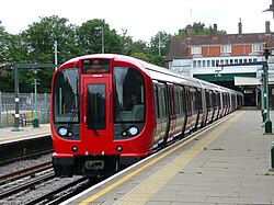
Since 20 September 2012, all services have been provided by eight-car S Stock trains [47] introduced in July 2010 to replace the 1960s A Stock. [48] Part of Bombardier's Movia family, they have air-conditioning, feasible because the sub-surface tunnels, unlike tube tunnels, are able to disperse the exhausted hot air. [49] [50] They have regenerative brakes, returning around 20% of their energy to the network and thus reducing energy consumption. [51] With fewer seats than the older A Stock – 306 compared with 448 – they can accommodate 697 standing passengers, compared with 597 in A Stock, [note 1] and have dedicated space for wheelchairs. [52] They have a top speed of 62 miles per hour (100 km/h), [49] being the only London Underground stock to travel at that speed, doing so on the long-distance sections north of Finchley Road.

There are 58 S8 Stock trains in operation, as well as one eight-car S7 Stock also called 'S7+1' – which retains the all-longitudinal seating of the normal seven-car S7 Stock that is operated on London Underground's other sub-surface lines.

Depot

The line is served by a depot at Neasden. [note 2] The Metropolitan Railway opened a carriage works at Neasden in 1882 and the following year the locomotive works were moved from Edgware Road. [53] In 1904–05, the depot was refitted to take the new electric multiple units [54] and accommodation enlarged in 1932–3. [55] After the amalgamation into the LTPB, the depot was rebuilt from 1936 to 1939. The depot was upgraded in 2010–11 to enable it to maintain S Stock trains. [56] Trains are also stored overnight at Uxbridge, Watford, Rickmansworth and Wembley Park. [57]

Steam on the Met

LMS Black 5 44932 at Amersham in 1992 Steam Train at Amersham Station - geograph.org.uk - 56745.jpg
LMS Black 5 44932 at Amersham in 1992

In 1989, to celebrate the 100th anniversary of the opening of the Metropolitan to Chesham, the first Steam on the Met event took place with London Underground running two weekends of steam specials between Chesham and Watford. [58] The event was a success and so in 1990 London Underground ran steam between Harrow and Amersham. In 1992, to celebrate 100 years of the Met at Amersham, the event was extended to five days at the end of May. From 1994, diesel locomotive 20227, owned by the Class 20 Locomotive Society, and electric locomotive Sarah Siddons provided air braking for the coaches.[ citation needed ] In 1995, trains ran between Amersham and Watford. [59]

Engines used included BR standard class 5 and BR standard class 4 and GWR Pannier tanks. There was other rolling stock on static display at Rickmansworth sidings. The steam trains ran between normal Metropolitan and main line services. Due to the imminent partial privatisation of LUL and the stock condition, the last steam excursion took place in 2000.[ citation needed ] In 2008, special trains ran on using Metropolitan Railway electric locomotive "Sarah Siddons" and diesel Class 20 locomotives. [60]

To celebrate the 150th anniversary of the opening of the Metropolitan, special services ran in January 2013 using a restored 1892 "Jubilee" carriage, 1898–1900 Ashbury and Cravens bogie carriages, Metropolitan Railway milk van No.3, Metropolitan Railway E Class steam locomotive No. 1 and electric locomotive Sarah Siddons. [61] Further events were planned for 2013 involving Locomotive No. 1, Sarah Siddons and the Jubilee carriage, including a Steam back on the Met scheduled for May. [62]

Four Lines Modernisation (4LM)

It was planned that a new signalling system would be used first on the line north of Baker Street from the end of 2016, [63] but signalling contractor Bombardier was released from its contract by agreement in December 2013 amid heavy criticism of the procurement process [64] and London Underground subsequently awarded the contract for the project to Thales in August 2015. [65]

With the introduction of S8 Stock, the track, electrical supply, and signalling systems are being upgraded in a programme planned to increase peak-hour capacity on the line by 27 per cent by the end of 2023. [63] [66] [67] A single control room for the sub-surface railway opened at Hammersmith on 6 May 2018, and communications-based train control (CBTC) provided by Thales will progressively replace 'fixed block' signalling equipment dating back the 1940s. [63] [68] Trackside signals with automatic train protection (ATP) will remain on the line north of Harrow-on-the-Hill, shared with Chiltern Railways DMUs. [63]

The rollout of CBTC has been split into sections, each known as a signal migration area (SMA), and are located on the line as follows: [69] .

Metropolitan line signal migration areas
SMA [lower-roman 1] fromtostatusdate
2Finchley RoadEuston SquarecompletedSeptember 2019
3Euston SquareAldgatecompletedJuly 2020
8Finchley RoadPreston Roadplanned2024
9Preston Road
  • West Harrow
  • Moor Park
plannedunder review
13Moor Park
  • Watford
  • Amersham
  • Chesham
plannedunder review
14West HarrowUxbridgedeferred
  1. SMAs 0.5, 1, 4–7 and 10–12 concern parts of the District, Circle, and Hammersmith & City lines.

Work on the SMAs north of Finchley Road were delayed in November 2023 because of the complexity of Neasden Depot (shared with the Jubilee Line) and challenges relating to the inter-operability with Chiltern Railways which shares tracks with the Metropolitan line in this area. [70]

List of stations

Open stations

In order from east to west.

StationImageOpened [17] BranchAdditional informationPosition
Aldgate Aldgate-Station-Entrance.jpg 18 November 1876Main

line

Terminus. Connects with Circle line 51°30′50″N000°04′34″W / 51.51389°N 0.07611°W / 51.51389; -0.07611 (01 – Aldgate tube station)
Liverpool Street National Rail logo.svg Overground roundel (no text).svg Elizabeth line roundel (no text).svg Liverpool Street Underground concourse entr.JPG 12 July 1875Main

line

Originally Bishopsgate, renamed 1 November 1909. Connects with Central and Hammersmith & City lines and London Overground, Elizabeth line and National Rail services from Liverpool Street mainline station. Elizabeth Line services via Stratford and Shenfield from platforms 15, 16 and 17. 51°31′07″N000°04′53″W / 51.51861°N 0.08139°W / 51.51861; -0.08139 (02 – Liverpool Street station) . Elizabeth line roundel (no text).svg .
Moorgate National Rail logo.svg Elizabeth line roundel (no text).svg Moorgate.jpg 23 December 1865Main

line

Originally Moorgate Street, renamed 24 October 1924. Connects with Northern line and National Rail services from the main line Northern City Line. The Elizabeth line is interchangeable via the Northern Line platforms from Liverpool Street Station due to the long platforms. 51°31′07″N000°05′19″W / 51.51861°N 0.08861°W / 51.51861; -0.08861 (03 – Moorgate station) .
Barbican Barbican Station.jpg 23 December 1865Main

line

Originally Aldersgate Street, renamed Aldersgate 1910, Aldersgate and Barbican 1923, Barbican 1968 51°31′13″N000°05′52″W / 51.52028°N 0.09778°W / 51.52028; -0.09778 (04 – Barbican tube station)
Farringdon Wheelchair symbol.svg National Rail logo.svg ThameslinkSymbol.svg Elizabeth line roundel (no text).svg Farringdon station exterior.jpg 10 January 1863Main

line

Resited 22 December 1865. Interchangeable with National Rail and Elizabeth line services. Originally Farringdon Street, renamed Farringdon & High Holborn 1922, Farringdon 1936 51°31′12″N000°06′19″W / 51.52000°N 0.10528°W / 51.52000; -0.10528 (05 – Farringdon station)
King's Cross St Pancras Wheelchair symbol.svg National Rail logo.svg Eurostar icon RDT (2023).svg King's Cross St Pancras tube stn Euston Rd NE entrance.JPG 10 January 1863Main

line

Station resited 1941. Originally King's Cross, renamed King's Cross & St Pancras 1925, King's Cross St Pancras 1933. Connects with Northern, Piccadilly and Victoria lines, National Rail services and Eurostar 51°31′49″N000°07′27″W / 51.53028°N 0.12417°W / 51.53028; -0.12417 (06 – King's Cross St Pancras tube station)
Euston Square Euston Square stn look east.JPG 10 January 1863Main

line

Originally Gower Street, renamed 1909 51°31′33″N000°08′09″W / 51.52583°N 0.13583°W / 51.52583; -0.13583 (07 – Euston Square tube station)
Great Portland Street Great Portland St Tube Station.jpg 10 January 1863Main

line

Originally Portland Road, renamed Great Portland Street 1917, Great Portland Street & Regent's Park 1923, Great Portland Street 1933 51°31′26″N000°08′38″W / 51.52389°N 0.14389°W / 51.52389; -0.14389 (08 – Great Portland Street tube station)
Baker Street BakerStEntrance.JPG 10 January 1863Main
line
Metropolitan line platforms date from 1868. Connects with Bakerloo, Circle, Hammersmith & City and Jubilee lines. 51°31′19″N000°09′25″W / 51.52194°N 0.15694°W / 51.52194; -0.15694 (09 – Baker Street tube station)
Finchley Road Finchley Road Tube.jpg 30 June 1879Main
line
Finchley Road (South Hampstead) from 1885 to 1914. Connects with Jubilee line. 51°32′50″N000°10′49″W / 51.54722°N 0.18028°W / 51.54722; -0.18028 (10 – Finchley Road tube station)
Wembley Park Wheelchair symbol.svg Wembley Park tube station extension.jpg 12 May 1894Main

line

Connects with Jubilee line. 51°33′49″N000°16′46″W / 51.56361°N 0.27944°W / 51.56361; -0.27944 (11 – Wembley Park tube station)
Preston Road Preston Road Tube Station.jpg 21 May 1908Main
line
Resited 1931/2 51°34′20″N000°17′43″W / 51.57222°N 0.29528°W / 51.57222; -0.29528 (12 – Preston Road tube station)
Northwick Park Northwick Park tube station 1.jpg 28 June 1923Main
line
Originally Northwick Park & Kenton, renamed 1937 51°34′43″N000°19′07″W / 51.57861°N 0.31861°W / 51.57861; -0.31861 (13 – Northwick Park tube station)
Harrow-on-the-Hill National Rail logo.svg Harrow-on-the-Hill stn north entrance.JPG 2 August 1880Main
line
Originally Harrow, renamed 1894. Connects with National Rail services. 51°34′46″N000°20′13″W / 51.57944°N 0.33694°W / 51.57944; -0.33694 (14 – Harrow-on-the-Hill station)
West Harrow West Harrow tube station 2.jpg 17 November 1913Uxbridge 51°34′47″N000°21′12″W / 51.57972°N 0.35333°W / 51.57972; -0.35333 (15 – West Harrow tube station)
Rayners Lane Rayners Lane stn building.JPG 26 May 1906UxbridgeConnects with Piccadilly line. 51°34′31″N000°22′17″W / 51.57528°N 0.37139°W / 51.57528; -0.37139 (16 – Rayners Lane tube station)
Eastcote Eastcote tube station 1.jpg 26 May 1906Uxbridge 51°34′36″N000°23′49″W / 51.57667°N 0.39694°W / 51.57667; -0.39694 (17 – Eastcote tube station)
Ruislip Manor Ruislip Manor tube station 1.jpg 5 August 1912Uxbridge 51°34′24″N000°24′45″W / 51.57333°N 0.41250°W / 51.57333; -0.41250 (18 – Ruislip Manor tube station)
Ruislip Ruislip station building.JPG 4 July 1904Uxbridge 51°34′17″N000°25′16″W / 51.57139°N 0.42111°W / 51.57139; -0.42111 (19 – Ruislip tube station)
Ickenham Ickenham tube station 1.jpg 25 September 1905UxbridgeOriginally Ickenham Halte, rebuilt 1970/1 51°33′43″N000°26′31″W / 51.56194°N 0.44194°W / 51.56194; -0.44194 (20 – Ickenham tube station)
Hillingdon Wheelchair symbol.svg Hillingdon stn entrance.JPG 10 December 1923UxbridgeRenamed Hillingdon (Swakeleys) 1934, suffix gradually dropped. Resited and rebuilt 1992 51°33′14″N000°27′00″W / 51.55389°N 0.45000°W / 51.55389; -0.45000 (21 – Hillingdon tube station)
Uxbridge Wheelchair symbol.svg Uxbridge station entrance.JPG 4 July 1904UxbridgeStation resited from Belmont Road in 1938
Terminus
51°32′45″N000°28′42″W / 51.54583°N 0.47833°W / 51.54583; -0.47833 (22 – Uxbridge tube station)
North Harrow N Harrow station.jpg 22 March 1915Main
line
51°35′06″N000°21′45″W / 51.58500°N 0.36250°W / 51.58500; -0.36250 (23 – North Harrow tube station)
Pinner Wheelchair symbol.svg Pinner tube station.jpg 25 May 1885Main
line
51°35′34″N000°22′50″W / 51.59278°N 0.38056°W / 51.59278; -0.38056 (24 – Pinner tube station)
Northwood Hills Northwood Hills tube station.jpg 13 November 1933Main
line
51°36′02″N000°24′33″W / 51.60056°N 0.40917°W / 51.60056; -0.40917 (25 – Northwood Hills tube station)
Northwood Northwood tube station.jpg 1 September 1887Main
line
The last station within Greater London 51°36′39″N000°25′28″W / 51.61083°N 0.42444°W / 51.61083; -0.42444 (26 – Northwood tube station)
Moor Park Moor Park stn main entrance.JPG 9 May 1910Main
line
Originally Sandy Lodge, renamed Moor Park & Sandy Lodge 18 October 1923, Moor Park 25 September 1950 51°37′47″N000°25′58″W / 51.62972°N 0.43278°W / 51.62972; -0.43278 (27 – Moor Park tube station)
Croxley Croxley Tube Station - exterior.JPG 2 November 1925WatfordOriginally Croxley Green, renamed 23 May 1949 51°38′51″N000°26′29″W / 51.64750°N 0.44139°W / 51.64750; -0.44139 (28 – Croxley tube station)
Watford Watford Tube Station.JPG 2 November 1925WatfordTerminus 51°39′27″N000°25′03″W / 51.65750°N 0.41750°W / 51.65750; -0.41750 (29 – Watford tube station)
Rickmansworth National Rail logo.svg Rickmansworth station building.JPG 1 September 1887Main
line
51°38′25″N000°28′24″W / 51.64028°N 0.47333°W / 51.64028; -0.47333 (30 – Rickmansworth station)
Chorleywood Wheelchair symbol.svg National Rail logo.svg Chorleywood station building.JPG 8 July 1889Main
line
The last station within Hertfordshire. Originally Chorley Wood, renamed Chorley Wood & Chenies 1 November 1915, Chorley Wood 1934, Chorleywood 1964 51°39′15″N000°31′06″W / 51.65417°N 0.51833°W / 51.65417; -0.51833 (31 – Chorleywood station)
Chalfont & Latimer Wheelchair symbol.svg National Rail logo.svg Chalfont & Latimer station building.JPG 8 July 1889Main
line
Originally Chalfont Road, renamed 1 November 1915 51°40′04″N000°33′40″W / 51.66778°N 0.56111°W / 51.66778; -0.56111 (32 – Chalfont & Latimer station)
Chesham Wheelchair symbol.svg Chesham station building.jpg 8 July 1889CheshamTerminus 51°42′19″N000°36′41″W / 51.70528°N 0.61139°W / 51.70528; -0.61139 (33 – Chesham tube station)
Amersham Wheelchair symbol.svg National Rail logo.svg Amersham tube station 1.jpg 1 September 1892AmershamRenamed Amersham & Chesham Bois 12 March 1922, Amersham 1937
Terminus. Connects with National Rail services.
51°40′27″N000°36′27″W / 51.67417°N 0.60750°W / 51.67417; -0.60750 (34 – Amersham station)

Former stations

LT loco L92 at Croxley tip in 1969 LT loco L92 in 1969.jpg
LT loco L92 at Croxley tip in 1969

The Brill Tramway with stations Waddesdon Road, Westcott, Wotton, Church Siding, Wood Siding and Brill closed in 1935. In the following year, the line was cut back to Aylesbury, with Waddesdon station and Granborough Road, Winslow Road stations on the line to Verney Junction closing. [17] Initially Verney Junction and Quainton Road remained open, with main line services provided by the LNER.

In 1939, the Stanmore branch and the stopping service between Finchley Road and Wembley Park were transferred to the Bakerloo line. On the St John's Wood section, Lord's and Marlborough Road stations were replaced by St John's Wood, and Swiss Cottage replaced the Metropolitan line station. [15] [17] The Bakerloo line service to Stanmore was transferred to the Jubilee line when that line opened in 1979. [16]

In 1961, when steam locomotives were replaced and the line was electrified to Amersham, the Underground service to Great Missenden, Wendover, Stoke Mandeville and Aylesbury was withdrawn. [17]

Goods-only branches

Between Moor Park and Croxley, a short branch ran south-east off the Watford branch, near its junction with the main line, to Croxley Tip, a rubbish dump beside the Grand Union Canal. This site began as a gravel loading point before becoming used by the railway to dump waste such as old ballast and waste from Neasden power station. This route, never used for passenger traffic, continued to be used by London Transport's small fleet of steam engines until 1971, when diesels replaced them. The branch closed some time after this, although a section of the spur line remained visible from a passing train.

A second short branch line, known as the Halton Railway, served RAF Halton near Wendover, across the Wendover Arm of the Grand Union Canal. The line was built during the First World War and closed in 1963. [71] The trackbed is now a footpath. [72]

Although not operated by Metropolitan passenger services, the line from South Harrow to Rayners Lane was built by the Metropolitan railway as the District Railway was in financial difficulties at the time. This included a short branch, part of which is still visible, on a viaduct to a gas works. Other minor freight connections along the line once included connections to the Midland main line at Finchley Road.

A single-track spur from a small yard between Ickenham and Ruislip stations connects to Ruislip Depot of the Central line. This line is used for engineering and empty stock transfers, although occasional plans suggest extending the Central line into Uxbridge by upgrading the connection. It was built in 1973.

Metropolitan line extension

Diagram of the Croxley Rail Link Croxley rail link.png
Diagram of the Croxley Rail Link

Also known as the Croxley Rail Link, an extension to the Metropolitan line was to reroute the Watford branch from the current terminus using the disused Croxley Green branch line to Watford Junction. Funding was agreed in December 2011 [73] and the necessary permission was granted by the UK Government in July 2013. [74] [39] [75] Due to a funding shortfall, the project was cancelled in 2016. [75]

Related Research Articles

<span class="mw-page-title-main">Baker Street tube station</span> London Underground station

Baker Street is a London Underground station at the junction of Baker Street and the Marylebone Road in the City of Westminster. It is one of the original stations of the Metropolitan Railway (MR), the world's first underground railway, opened on 10 January 1863.

<span class="mw-page-title-main">Moorgate station</span> London Underground and railway station

Moorgate is a central London railway terminus and connected London Underground station on Moorgate in the City of London. Main line railway services for Hertford, Welwyn Garden City and Stevenage are operated by Great Northern, while the Underground station is served by the Circle, Hammersmith & City, Metropolitan and Northern lines.

<span class="mw-page-title-main">Rayners Lane tube station</span> London Underground station

Rayners Lane is a London Underground station in the district of Rayners Lane in north west London, amid a 1930s development originally named Harrow Garden Village. The station is on the Uxbridge branch of both the Metropolitan line, between Eastcote and West Harrow stations, and the Piccadilly line, between Eastcote and South Harrow stations. The station is located to the west of the junction of Rayners Lane, Alexandra Avenue and Imperial Drive (A4090). It is in Travelcard Zone 5. Just east of the station, the Piccadilly and Metropolitan lines tracks join for services to Uxbridge and separate for those to Central London.

<span class="mw-page-title-main">Euston Square tube station</span> London Underground station

Euston Square is a London Underground station at the corner of Euston Road and Gower Street, just north of University College London – its main (south) entrance faces the tower of University College Hospital. The multi-interchange Euston station is beyond Euston Square Gardens, which is one street east. The station is between Great Portland Street and King's Cross St Pancras on the Circle, Hammersmith & City and Metropolitan lines in Travelcard Zone 1.

<span class="mw-page-title-main">Great Portland Street tube station</span> London Underground station

Great Portland Street is a London Underground station near Regent's Park. It is between Baker Street and Euston Square on the Hammersmith & City, Circle and Metropolitan lines. Great Portland Street station is listed as a building of National Significance and lies in Travelcard Zone 1.

<span class="mw-page-title-main">Barbican tube station</span> London Underground station

Barbican is a London Underground station situated near the Barbican Estate, on the edge of the ward of Farringdon Within, in the City of London in Central London. It has been known by various names since its opening in 1865, mostly in reference to the neighbouring ward of Aldersgate.

<span class="mw-page-title-main">Chalfont & Latimer station</span> London Underground and railway station

Chalfont & Latimer is a London Underground and National Rail station in Travelcard Zone 8 on the Metropolitan line, in Buckinghamshire. It also serves the Chiltern Railways line to Aylesbury. Chalfont & Latimer station is located just before the junction for trains to Chesham. The station serves Chalfont St Giles, Chalfont St Peter, Little Chalfont and Latimer. It is located in Little Chalfont. It opened as "Chalfont Road" on 8 July 1889 but changed to the present name from 1 November 1915. The station is a good location to alight from to explore the Chess Valley.

<span class="mw-page-title-main">Eastcote tube station</span> London Underground station

Eastcote is a London Underground station in Eastcote in the west of Greater London. The station is on the Uxbridge branch of both the Metropolitan line and Piccadilly line, between Ruislip Manor and Rayners Lane stations. The station is located on Field End Road. It is in Travelcard Zone 5.

<span class="mw-page-title-main">Northwick Park tube station</span> London Underground station

Northwick Park is a London Underground station in Kenton in the London Borough of Brent on the Metropolitan line. It lies between Harrow-on-the-Hill and Preston Road stations and is in Travelcard zone 4. The station takes its name from the nearby public park, Northwick Park.

<span class="mw-page-title-main">Metropolitan Railway</span> Underground railway in London 1863–1933

The Metropolitan Railway was a passenger and goods railway that served London from 1863 to 1933, its main line heading north-west from the capital's financial heart in the City to what were to become the Middlesex suburbs. Its first line connected the main-line railway termini at Paddington, Euston, and King's Cross to the City. The first section was built beneath the New Road using cut-and-cover between Paddington and King's Cross and in tunnel and cuttings beside Farringdon Road from King's Cross to near Smithfield, near the City. It opened to the public on 10 January 1863 with gas-lit wooden carriages hauled by steam locomotives, the world's first passenger-carrying designated underground railway.

<span class="mw-page-title-main">Chesham tube station</span> London Underground station

Chesham tube station is a London Underground station in Chesham, Buckinghamshire, United Kingdom. It was opened on 8 July 1889 by the Metropolitan Railway (MR). It is the terminus station of the Chesham branch of the Metropolitan line, which runs from Chalfont & Latimer. The station, a Grade II listed building, is in London fare Zone 9.

<span class="mw-page-title-main">Chorleywood station</span> London Underground and railway station

Chorleywood is a London Underground and National Rail station in Travelcard Zone 7 on the Metropolitan line. The village of Chorleywood is in the Three Rivers district of Hertfordshire about 20 miles (32 km) from London. Chorleywood station is also served by Chiltern Railways, which runs trains from London Marylebone station through to Aylesbury.

<span class="mw-page-title-main">Harrow-on-the-Hill station</span> London Underground and railway station

Harrow-on-the-Hill is an interchange railway station in Harrow, served by suburban London Underground Metropolitan line services and commuter National Rail services on the London–Aylesbury line. It is 9 miles 18 chains down the line from London Marylebone. Harrow-on-the-Hill is the final Metropolitan line stop from Central London before the line splits with the main branch towards Moor Park and the diverged Uxbridge branch towards Uxbridge. It is in Travelcard Zone 5.

<span class="mw-page-title-main">West Harrow tube station</span> London Underground station

West Harrow is a London Underground station in Harrow in north west London.

<span class="mw-page-title-main">Ickenham tube station</span> London Underground station

Ickenham is a London Underground station located in Ickenham in the London Borough of Hillingdon. The station is on the Uxbridge branch of both the Metropolitan line and Piccadilly line, between Ruislip and Hillingdon stations. It is in Travelcard Zone 6.

<span class="mw-page-title-main">Preston Road tube station</span> London Underground station

Preston Road is a London Underground station in Preston Road in the London Borough of Brent. It is on the Metropolitan line between Northwick Park and Wembley Park stations and is in Travelcard Zone 4. It serves the local area of Preston in Wembley and parts of Kenton.

<span class="mw-page-title-main">Rickmansworth station</span> London Underground and Chiltern Railways station

Rickmansworth is an interchange railway station in Rickmansworth, Hertfordshire, northwest of central London, served by the London Underground Metropolitan line and by Chiltern Railways. It is one of the few London Underground stations beyond Greater London and as a consequence is in Travelcard Zone 7. The station is a good location to alight from to explore the Chess Valley.

<span class="mw-page-title-main">London–Aylesbury line</span> Railway line in the UK

The London–Aylesbury line is a railway line between London Marylebone and Aylesbury, going via the Chiltern Hills; passenger trains are operated by Chiltern Railways. Nearly half of the line is owned by London Underground, approximately 16 miles (26 km) – the total length of the passenger line is about 39 miles (63 km) with a freight continuation.

<span class="mw-page-title-main">Chesham branch</span> Branch line of the London Underground

The Chesham branch is a single-track railway branch line in Buckinghamshire, England, owned and operated by the London Underground. It runs from a junction at Chalfont & Latimer station on the Metropolitan line for 3.89 miles (6.26 km) northwest to Chesham. The line was built as part of Edward Watkin's scheme to turn his Metropolitan Railway (MR) into a direct rail route between London and Manchester, and it was envisaged initially that a station outside Chesham would be an intermediate stop on a through route running north to connect with the London and North Western Railway (LNWR). Deteriorating relations between the MR and LNWR led to the MR instead expanding to the northwest via Aylesbury, and the scheme to connect with the LNWR was abandoned. By this time much of the land needed for the section of line as far as Chesham had been bought. As Chesham was at the time the only significant town near the MR's new route, it was decided to build the route only as far as Chesham, and to complete the connection with the LNWR at a future date if it proved desirable. Local residents were unhappy at the proposed station site outside Chesham, and a public subscription raised the necessary additional funds to extend the railway into the centre of the town. The Chesham branch opened in 1889.

London's Metropolitan Railway (MR) amalgamated with other underground railways, tramway companies and bus operators on 1 July 1933, to form the London Passenger Transport Board (LPTB); the MR became the Board's Metropolitan line.

References

Footnotes

Notes

  1. Baracaia, Alexa (22 August 2006). "Seven Wonders of London". London Evening Standard. p. 21 via newspapers.com.
  2. TfL Corporate Design (January 2009). "3: Underground line colours". Line diagram standard (PDF) (3 ed.). Transport for London. Archived from the original (PDF) on 4 January 2022. Metropolitan line - Pantone 235, C:5 M:100 K:40
  3. "London Assembly Questions to the Mayor". London Assembly. 2022. Retrieved 29 February 2024.
  4. Green 1987, pp. 3–5.
  5. Edwards, Dennis; Pigram, Ron (1988). The Golden Years of the Metropolitan Railway and the Metro-land Dream. Bloomsbury. p. 32. ISBN   1-870630-11-4.
  6. Pipe, Victoria; Marshall, Geoff (2018). The Railway Adventures: Places, Trains, People and Stations. Tewkesbury: September Publishing. p. 82. ISBN   9781910463871.
  7. Bobrick, Benson (1981). Labyrinths of Iron . Newsweek books. p.  142. ISBN   9780882252995.
  8. Green 1987, pp. 7–10.
  9. Green 1987, pp. 11–14.
  10. Green 1987, pp. 24–26.
  11. "A Trip on the Metropolitan Railway (1910)". Screen Online. British Film Institute. Retrieved 25 January 2016.
  12. Green 1987, pp. 43–45.
  13. Green 1987, pp. 46–48.
  14. Horne 2003, p. 69.
  15. 1 2 Green 1987, p. 51.
  16. 1 2 Green 1987, p. 63.
  17. 1 2 3 4 5 6 7 Rose, Douglas (December 2007) [1980]. The London Underground: A Diagrammatic History (8th ed.). London: Capital Transport. ISBN   978-1-85414-315-0.
  18. Bruce 1983, pp. 72–74.
  19. Bruce 1983, pp. 78–81.
  20. Green 1987, p. 55.
  21. Bruce 1983, p. 110.
  22. Bruce 1983, p. 113.
  23. Croome, Desmond F.; Jackson, Alan Arthur (1993). Rails Through the Clay: A History of London's Tube Railways. Capital Transport. p. 468. ISBN   978-1-85414-151-4.
  24. "London Underground map 1968". The London Tube map archive. Retrieved 21 November 2012.
  25. "London Underground map 1970". The London Tube map archive. Retrieved 21 November 2012.
  26. "London Underground map 1985". The London Tube map archive. Retrieved 21 November 2012.
  27. 1 2 "London Underground map 1990". The London Tube map archive. Retrieved 21 November 2012.
  28. "PPP Performance Report" (PDF). Transport for London. 2009–2010. pp. 7–8. Archived from the original (PDF) on 26 April 2012. Retrieved 7 March 2012.
  29. "Chesham trains to run direct into central London" (Press release). Transport for London. 7 December 2010. Archived from the original on 17 April 2012. Retrieved 21 March 2018.
  30. "A Stock last day on the Metropolitan Line". Railways Today. 26 September 2012. Archived from the original on 19 January 2016. Retrieved 2 November 2012.
  31. "Last A stock rail tour". London Transport Museum. Archived from the original on 1 October 2012. Retrieved 27 September 2012.
  32. 1 2 "Key facts". Transport for London. Archived from the original on 29 May 2007. Retrieved 22 November 2012.
  33. Richard Griffin (3 September 2019). "SQUAREWHEELS.org.uk – S stock". www.squarewheels.org.uk. Retrieved 11 May 2020.
  34. Martin, Andrew (2012). Underground, Overground: A Passenger's History of the Tube. London: Profile Books. pp. 137–138. ISBN   978-1-84765-807-4 . Retrieved 7 December 2012.
  35. "Metropolitan line facts". Transport for London. Retrieved 23 November 2012.
  36. 1 2 3 4 5 6 7 8 "Detailed London Transport Map". cartometro.com. Retrieved 23 November 2012.
  37. Marius, Callum (16 August 2021). "Why the Metropolitan line has 2 extra secret stations you may not know about". MyLondon. Retrieved 4 November 2022.
  38. Horne 2003, p. x.
  39. 1 2 "Croxley Rail Link". Transport for London. 2012. Archived from the original on 25 March 2013. Retrieved 23 November 2012.
  40. Louis, Nathan (8 August 2021). "The 'secret' Met line track near Watford known as 'North Curve'". Watford Observer. Retrieved 15 September 2021.
  41. "Amersham/Chesham tube guide" (PDF). Transport for London. Retrieved 9 December 2013.
  42. 1 2 Kichenside, G.M.; Williams, Alan. British Railway Signalling. p. 72.
  43. "Facts & figures". tfl.gov.uk. Transport for London. Retrieved 14 July 2017.
  44. 1 2 3 4 5 6 7 8 9 "Working timetable 340 - Metropolitan line" (PDF). Archived from the original (PDF) on 21 May 2017. Retrieved 5 May 2018.
  45. Detailed London transport map - Carto Metro
  46. "Working timetable 35 - Circle and Hammersmith & City lines" (PDF). Archived from the original (PDF) on 15 June 2021. Retrieved 27 March 2020.
  47. "Commissioner's Report" (PDF). Board Meeting Documents. Transport for London. 20 September 2012. paragraph 3.2. Archived (PDF) from the original on 26 August 2020. Retrieved 27 September 2012.
  48. Waboso, David (December 2010). "Transforming the tube". Modern Railways. London. pp. 42–45.
  49. 1 2 "Movia metro – London, United Kingdom". Bombardier. Retrieved 27 January 2011.
  50. "'S' stock making its mark". Modern Railways. London. December 2010. p. 46.
  51. "Transforming the Tube" (PDF). Transport for London. July 2008. Archived from the original (PDF) on 5 June 2011. Retrieved 28 May 2009.
  52. Jackson 1986, pp. 82–82.
  53. Jackson 1986, p. 176.
  54. Jackson 1986, p. 281.
  55. "Works begin to build new maintenance facility at Neasden Depot". Transport for London. 28 September 2010. Retrieved 11 February 2011.
  56. "London Underground Key Facts". Transport for London. Archived from the original on 29 May 2007. Retrieved 21 May 2008.
  57. metroland.org.uk. "Steam on the Met".
  58. King, Geoffrey. "Steam on the Met".
  59. "Not quite Steam on the Met". peat.me.uk. 30 August 2008. Retrieved 24 November 2011.
  60. "Past Events – tube 150". London Transport Museum. Archived from the original on 29 October 2013. Retrieved 4 February 2013.
  61. "Vehicles on the Move" (Press release). London Transport Museum. Archived from the original on 1 October 2012. Retrieved 4 February 2013.
  62. 1 2 3 4 Abbott, James (January 2013). "Sub-surface renewal". Modern Railways. pp. 38–41.
  63. "London Underground and Bombardier abandon Tube signalling contract". International Railway Journal. 3 January 2014. Retrieved 2 June 2020.
  64. "London Underground resignalling reaches milestone". International Railway Journal. 13 October 2017. Retrieved 2 June 2020.
  65. "Our Upgrade Plan" (PDF). Transport for London. February 2011. Archived from the original (PDF) on 17 August 2012. Retrieved 7 December 2012.
  66. "Four Lines Modernisation". Transport for London. Retrieved 2 June 2020.
  67. Stewart, Rob (January 2013). "Cityflo 650 to control the SSR". Modern Railways. pp. 42–43.
  68. "Underground News". London Underground Railway Society. 706: 572. October 2020.
  69. "FOI Request Detail - 4LM". Transport for London. November 2023. Retrieved 20 January 2024.
  70. "Halton Railway". RAF Halton . MOD. Retrieved 6 September 2015.
  71. The Wendover Arm: Linear and Circular Walks (PDF). Aylesbury: Buckinghamshire County Council. Retrieved 6 September 2015.
  72. "Transport schemes given £854m in government funding". BBC News. 14 December 2011. Retrieved 14 December 2011.
  73. "Watford Metropolitan line Tube extension gets go-ahead". BBC News. 24 July 2013. Retrieved 24 July 2013.
  74. 1 2 "Metropolitan line Extension". Transport for London. 2017. Archived from the original on 17 July 2017.

Sources

Further reading

Template:Attached KML/Metropolitan line
KML is from Wikidata