
Woolwich Arsenal station is an interchange station in the heart of Woolwich in the Royal Borough of Greenwich for Docklands Light Railway (DLR) and National Rail services.

Limehouse is a National Rail and connected Docklands Light Railway (DLR) station in Limehouse, London, England. It is served by regional services operated by c2c to and from Fenchurch Street, and by light metro services provided by the DLR to and from Tower Gateway or Bank. On the main line, Limehouse is located 1 mile 58 chains (2.8 km) from Fenchurch Street and the following station is West Ham; on the DLR it is between Shadwell and Westferry in Travelcard Zone 2.
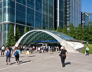
Canary Wharf is a London Underground station at Canary Wharf and is on the Jubilee line, between Canada Water and North Greenwich stations. The station is located in Travelcard Zone 2 and was opened on 17 September 1999 as part of the Jubilee Line Extension. Over 40 million people pass through the station each year, making it second busiest on the London Underground outside Central London after Stratford, and also the busiest that serves only a single line.

Canning Town is an interchange station located in Canning Town, London for London Underground, Docklands Light Railway (DLR) and London Buses services.
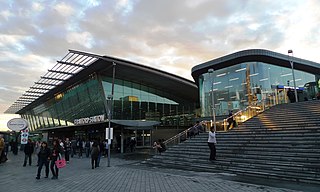
Stratford is a major multi-level interchange station serving the town of Stratford and the mixed-use development known as Stratford City, in the London Borough of Newham, East London for London Underground, London Overground, Docklands Light Railway (DLR) and Elizabeth line services. National Rail services also operate on the West Anglia Main Line and the Great Eastern Main Line, 4 miles 3 chains (6.5 km) from Liverpool Street.

Lewisham is an interchange station in Lewisham, south-east London, for Docklands Light Railway (DLR) and National Rail services.

Whitechapel is an interchange station in Whitechapel, East London for London Underground, London Overground and Elizabeth line services. The station is located behind a street market of the same name and opposite Tower Hamlets Town Hall. The station was comprehensively rebuilt in the late 2010s and early 2020s as part of the Crossrail project.

Custom House is an interchange station by the Royal Docks, in Custom House in the London Borough of Newham, London for Docklands Light Railway (DLR) – on which it is branded Custom House for ExCeL – and Elizabeth line services. It is situated in Travelcard Zone 3.

Mile End is a London Underground station in Mile End, London. It is served by the Hammersmith & City, District and Central lines. This station features a cross-platform interchange in both directions; District and Hammersmith & City lines stop on the inside tracks, and the Central line stops on the outside tracks. It is in Travelcard Zone 2.

Bow Road is a London Underground station located on Bow Road in Bow, London, England. It is on the District and Hammersmith & City lines. The station is interlinked as an out of station interchange (OSI) with Bow Church station on the Docklands Light Railway which is about 300 m (980 ft) away via Bow Road. The two stations are classed as a single station for ticketing purposes as well as on tube maps but both are managed separately.
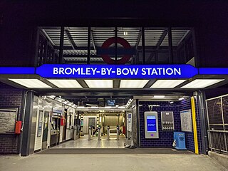
Bromley-by-Bow is a London Underground station located on the Blackwall Tunnel Northern Approach Road in the Bromley-by-Bow area of London, United Kingdom. The station is below the Blackwall Tunnel Northern Approach Road and lies between Bow Road and West Ham stations on the District and Hammersmith & City lines, and is in both Travelcard Zones 2 and 3.

Barking is an interchange station serving the town of Barking, east London. It is served by London Underground, London Overground and National Rail main line services. It is located on Station Parade, in the town centre.
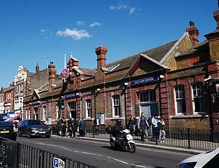
East Ham is a London Underground station on High Street North in the East Ham neighbourhood of the London Borough of Newham in east London, England. The station is on the District line and Hammersmith & City line. The station was opened on 31 March 1858 by the London, Tilbury and Southend Railway on a new more direct route from Fenchurch Street to Barking. The large Edwardian station building was constructed to accommodate the electric District Railway services on an additional set of tracks opened in 1905. It has high and growing usage for a suburban station with 13.1 million entries and exits in 2010. It is in London fares zones 3 and 4.

The London, Tilbury and Southend line, also known as Essex Thameside, is a commuter railway line on the British railway system. It connects Fenchurch Street station, in central London, with destinations in east London and Essex, including Barking, Upminster, Basildon, Grays, Tilbury, Southend and Shoeburyness.

Hornchurch is a London Underground station serving the town of Hornchurch in the London Borough of Havering, east London. It is on the District line between Elm Park to the west and Upminster Bridge to the east. It is 2.5 kilometres (1.6 mi) along the line from the eastern terminus at Upminster and 31.7 kilometres (19.7 mi) to Earl's Court in central London where the line divides into numerous branches.
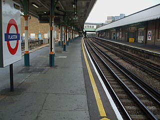
Plaistow is a London Underground station on Plaistow Road in the London Borough of Newham in Greater London. It is between West Ham and Upton Park stations on the District and Hammersmith & City lines, and in Travelcard Zone 3.

Stratford International is a National Rail station in Stratford and a separate Docklands Light Railway (DLR) station nearby, located in East Village in London. Despite its name, no international services stop at the station; plans for it to be served by Eurostar trains never came to fruition. The National Rail platforms are served by Southeastern trains on the High Speed 1 route originating at London St Pancras International. On the DLR, it is a terminus – one of seven end-of-the-line termini – for local services via Canning Town and London City Airport.
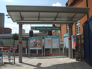
Stratford High Street is a Docklands Light Railway station in Stratford in London, England. It is located on the Stratford International branch of the Docklands Light Railway, which opened on 31 August 2011. The site was the location of an earlier railway station from 1847 to 1957, known initially as Stratford Bridge and later as Stratford Market - after the nearby wholesale fruit and vegetable market.

Abbey Road DLR station is a Docklands Light Railway station in West Ham in the London Borough of Newham, in east London, England. It is located on the Stratford International extension of the Docklands Light Railway.

Star Lane is a Docklands Light Railway (DLR) station in Canning Town, east London. Located on the Stratford International extension of the Docklands Light Railway between Stratford and Canning Town, it opened on 31 August 2011.


