South Kensington is a London Underground station in the district of South Kensington, south west London. It is served by the District, Circle and Piccadilly lines. On the District and Circle lines it is between Gloucester Road and Sloane Square, and on the Piccadilly line between Gloucester Road and Knightsbridge. It is in Travelcard Zone 1. The main station entrance is located at the junction of Old Brompton Road (A3218), Thurloe Place, Harrington Road, Onslow Place and Pelham Street. Subsidiary entrances are located in Exhibition Road giving access by pedestrian tunnel to the Natural History, Science and Victoria and Albert Museums. Also close by are the Royal Albert Hall, Imperial College London, the Royal College of Music, the London branch of the Goethe-Institut and the Ismaili Centre.

Edgware Road is a London Underground station on the Circle, District and Hammersmith & City lines, located on the corner of Chapel Street and Cabbell Street, within Travelcard zone 1. A separate station of the same name but served by the Bakerloo line is located about 150 metres away on the opposite side of Marylebone Road.
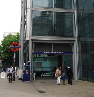
Euston Square is a London Underground station at the corner of Euston Road and Gower Street, just north of University College London – its main (south) entrance faces the tower of University College Hospital. The multi-interchange Euston station is beyond Euston Square Gardens, which is one street east. The station is between Great Portland Street and King's Cross St Pancras stations on the Circle, Hammersmith & City and Metropolitan lines in Travelcard Zone 1.

Gloucester Road is a London Underground station in Kensington, west London. The station entrance is located close to the junction of Gloucester Road and Cromwell Road. Close by are the Cromwell Hospital and Baden-Powell House.

High Street Kensington is a London Underground station on Kensington High Street, in Kensington. The station is on the Circle line between Gloucester Road and Notting Hill Gate, and the District line between Earl's Court and Notting Hill Gate and is in Travelcard Zone 1. Kensington Arcade forms the entrance to the station.

Mansion House is a London Underground station in the City of London which takes its name from Mansion House, the residence of the Lord Mayor of London. It opened in 1871 as the eastern terminus of the Metropolitan District Railway. Today, Mansion House is served by the Circle and District lines. It is between Blackfriars and Cannon Street stations and it is in fare zone 1. The station is located at the junction of Queen Victoria Street and Cannon Street.

Sloane Square is a London Underground station in Chelsea, serving Sloane Square. It is served by the District and Circle lines, between South Kensington and Victoria stations and is in Travelcard Zone 1.

Barbican is a London Underground station situated near the Barbican Estate, on the edge of the ward of Farringdon Within, in the City of London in Central London. It has been known by various names since its opening in 1865, mostly in reference to the neighbouring ward of Aldersgate.
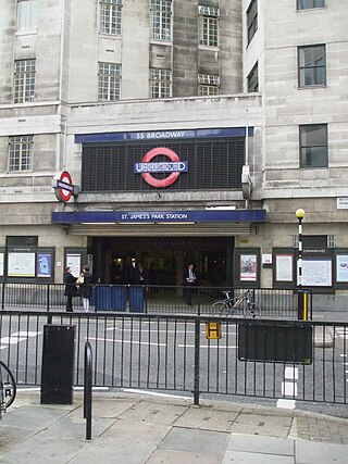
St James's Park is a London Underground station near St James's Park in the City of Westminster, central London. It is served by the District and Circle lines and is between Victoria and Westminster stations. It is in Travelcard Zone 1.

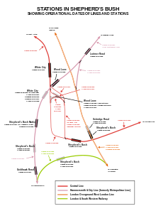
Barons Court is a London Underground station in West Kensington in the London Borough of Hammersmith and Fulham, Greater London. This station serves the District line and the Piccadilly line. Barons Court is between West Kensington and Hammersmith on the District line, and between Earl's Court and Hammersmith on the Piccadilly line and is in Travelcard Zone 2. East of the station, the Piccadilly line descends into tunnel towards Earl's Court and the District line continues in a cutting to West Kensington. The station is the last open air stop for eastbound trains on the Piccadilly line until Arnos Grove and has cross-platform interchange with the District line.
Stepney Green is a London Underground station located on Mile End Road in Stepney, London, United Kingdom. It is between Whitechapel and Mile End on the District line and the Hammersmith & City line, and is in Travelcard Zone 2.

Bow Road is a London Underground station located on Bow Road in Bow, London, England. It is on the District and Hammersmith & City lines. The station is interlinked as an out of station interchange (OSI) with Bow Church station on the Docklands Light Railway which is about 300 m (980 ft) away via Bow Road. The two stations are classed as a single station for ticketing purposes as well as on tube maps but both are managed separately.
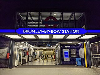
Bromley-by-Bow is a London Underground station located on the Blackwall Tunnel Northern Approach Road in the Bromley-by-Bow area of London, United Kingdom. The station is below the Blackwall Tunnel Northern Approach Road and lies between Bow Road and West Ham stations on the District and Hammersmith & City lines, and is in both Travelcard Zones 2 and 3.

Alperton is a London Underground station in Alperton, north-west London. It is on the Uxbridge branch of the Piccadilly line between Sudbury Town and Park Royal stations, in Travelcard Zone 4. It is located on Ealing Road (A4089), a short distance from the junction with Bridgewater Road (A4005), and is close to the Paddington branch of the Grand Union Canal.
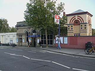
West Brompton is a Grade II-listed interchange station located on Old Brompton Road (A3218) in West Brompton, West London. The station is served by the District line of the London Underground; the Mildmay line of the London Overground; and National Rail services operated by Southern along the West London line.

Ladbroke Grove is a London Underground station on the Circle and Hammersmith & City lines, between Latimer Road and Westbourne Park stations, and in Travelcard Zone 2 set in The Royal Borough of Kensington and Chelsea.

Sudbury Town is a London Underground station in Sudbury, north-west London. It is on the Uxbridge branch of the Piccadilly line between Sudbury Hill and Alperton stations, and is in Travelcard Zone 4. It is located on the border between the London Boroughs of Brent and Ealing, with its main entrance on Station Approach in Sudbury. The forecourt of the station is known as Station Crescent. The station serves Sudbury, which forms the western part of Wembley.

West Kensington is a London Underground District line station in West Kensington. It is located on North End Road (B317) close to its junction with West Cromwell Road/Talgarth Road (A4).

Stamford Brook is a London Underground station on the eastern edge of Chiswick in west London. The station is served by the District line and is between Ravenscourt Park and Turnham Green stations. The main entrance is located on Goldhawk Road (A402) with a secondary entrance on Prebend Gardens. It is in Travelcard Zone 2.
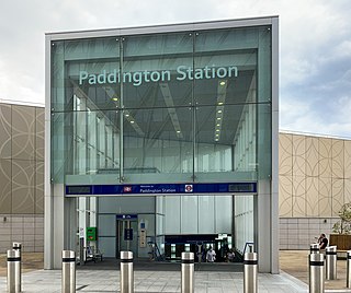
Paddington is a London Underground station served by the Circle and Hammersmith & City lines. It is located adjacent to the north side of Paddington mainline station and has entrances from within the mainline station and from Paddington Basin. The station is between Royal Oak and Edgware Road and is in London Fare Zone 1.