The modern borough was created in 1965 under the London Government Act 1963, which reorganised 86 boroughs and urban districts into 32 London boroughs and also created the Greater London Council. It was a merger of the old metropolitan boroughs of Chelsea and Kensington, and it inherited Kensington's royal borough status.[5] The new borough was originally intended to be called only "Kensington", but after protests from thousands of Chelsea residents, the then Minister of Housing and Local Government, Sir Keith Joseph, announced on 2 January 1964 that the name of the new borough would be the Royal Borough of Kensington and Chelsea.[6]
Of its history the council states: "Despite the boroughs being separate originally, Kensington and Chelsea still retain their unique characters. Even the amalgamation of the two boroughs, unpopular as it was at the time, has been accepted. Today conservation combined with the adoption of sympathetic new architecture is seen as a key objective. In every corner of the borough signs of its history can be seen: from Grade 1 listed buildings Kensington Palace and the Royal Hospital, Chelsea to others recalled in street names such as Pottery Lane and Hippodrome Mews."[7]
In 200 years the area has been transformed from a "rural idyll" to a thriving part of the modern metropolis. Chelsea had originally been countryside upon which Thomas More built Beaufort House. He came to Chelsea in 1520 and built the house, which in his day had two courtyards laid out between the house and the river, and in the north of the site acres of gardens and orchards were planted. It was from here in 1535 that More was taken to the Tower and beheaded later that year.[8] This area of Cheyne Walk continued its historic significance; nearby Crosby Hall sits on the river near the Church of Thomas More, and what was once Thomas Carlyle's residence remains on Cheyne Row.
Kensington's royal borough status was granted in 1901 as it included of Kensington Palace, where Queen Victoria was born in 1819 and lived until her accession in 1837. Commissioned by King William III, Christopher Wren enlarged and rebuilt the original house in 1689, turning it into a fitting royal residence. With the King came many court officials, servants and followers. Kensington Square, until then a failing venture, became a popular residential area. The Palace was regularly used by reigning monarchs until 1760 and since then by members of the Royal family.[9] Kensington's royal borough status was inherited by the new borough.
Most parks and open spaces in this borough are quite small, the majority being squares built to service houses around them. However, the area does contain larger parks, including Kensington Gardens and parts of Hyde Park, as well as parts of the Magnificent Seven cemeteries.
Kensington and Chelsea, held by Sir Malcolm Rifkind for the Conservative Party, and
Regent's Park and Kensington North (partly in City of Westminster), held by Karen Buck for the Labour Party.
Rifkind held the Kensington seat until the 2015 General Election when he stood down after becoming embroiled in a scandal, uncovered by a television investigation, over accepting money in return for access to influential British diplomats and politicians.[11]
Within the Royal Borough of Kensington and Chelsea, Kensington Palace is located on Kensington Palace Gardens—a tree-lined avenue that is home to embassies and high commissions, with additional diplomatic missions throughout the borough:
At the 2011 census, the borough had a population of 158,649 who were 71 per cent White, 10 per cent Asian, 5 per cent of multiple ethnic groups, 4 per cent Black African and 3 per cent Black Caribbean. It is the least populated of the 32 London boroughs. Due to its high French population it has long held the unofficial title of the 21st arrondissement of Paris.[13]
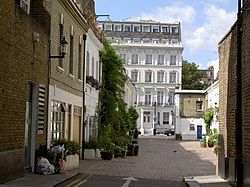
A typical mews in the Royal Borough of Kensington and Chelsea
In 2005, the borough had more of its land covered by domestic buildings than anywhere else in England at 19%, over half the national average.[14] It also had the fifth highest proportion of land covered by non-domestic buildings at 12 percent.[14]
As of 2010 statistics released by the Office for National Statistics showed that life expectancy at birth for females was 89.8 years in 2008–2010, the highest in the United Kingdom. Male life expectancy at birth for the same period was 85.1 years.[15] The figures in 1991–1993 were significantly lower: 73.0 years for males (ranking 301st in the nation) and 80.0 for females (ranking 129th). Further investigation indicates a 12-year gap in life expectancy between the affluent wards of Chelsea (Royal Hospital, Hans Town) and the most northerly wards of North Kensington (Golborne, Dalgarno), which have high levels of social housing and poverty.
The borough has a higher proportion (16.6 percent) of high earners (over £60,000 per year) than any other local government district in the country.[16] It has the highest proportion of workers in the financial sector and the lowest proportion working in the retail sector.
In December 2006 Sport England published a survey which showed that the borough's residents were the fourth most active in England in sports and other fitness activities. 27.9 percent of the population participate at least three times a week for 30 minutes.[17]
A 2017 study by Trust for London[18] and the New Policy Institute[19] found that Kensington & Chelsea has the greatest income inequality of any London Borough. Private rent for low earners was also found to be the least affordable in London. However, the borough's poverty rate of 28% is roughly in line with the London-wide average.[20]
Chelsea (SW3, SW10 and partly SW1) has significantly less Underground access than Kensington, the only station within Chelsea being Sloane Square. There have for some time been long-term plans for a Chelsea-Hackney line, with a station in the King's Road near Chelsea Town Hall, and possibly another at Sloane Square. As of June 2019, the plans for Crossrail 2 materialising show the proposed route tunnelling through Chelsea and featuring the planned King's Road Chelsea station on the site of Dovehouse Green. The future of this station, being the only fully new station on the proposed line, remains ambiguous; initial reports of the station idea having been scrapped [30] seem to be contradicted by the station's placement on an official Transport for London map for the route.[31]
A Crossrail station on the original Crossrail route, from Paddington to Reading, has been proposed and endorsed by the council.[32] This station would be located near the northern end of Ladbroke Grove, and would serve the areas of North Kensington and Kensal. The council supports this station concept as it would renew infrastructure and build regeneration benefits in the area.
Kensington and Chelsea council has been criticised for its lack of support for cycle lanes and active travel in general. In 2019 the council vetoed a flagship programme by Transport for London for safer walking and cycling in the borough.[33] In 2020 it scrapped a cycle lane along Kensington High Street just seven weeks after it was installed.[34]
Travel to work
In March 2011 the main forms of transport that residents used to travel to work were: underground, metro, light rail, tram, 23.6 percent of all residents aged 16–74; driving a car or van, 8.2 percent; on foot, 8.2 percent; bus, minibus or coach, 8.0 percent; work mainly at or from home, 7.0 percent; bicycle, 3.1 percent; train, 2.1 percent.[35]
Social housing and Grenfell tower fire
Grenfell Tower in the early morning of 14 June 2017.
The 2017 Grenfell Tower fire, in which one public-housing tower of the estate Grenfell Tower was completely destroyed and 72 lives were lost, drew international attention to the borough. After widespread criticism of the borough council's response to the fire,[37][38] responsibility for providing services to those affected by the fire was taken away from RBKC.[39] Prime Minister Theresa May previously branded the response to the tragedy "not good enough", with Whitehall civil servants drafted in as part of a beefed-up operation in the local area. Anna Stec who gave evidence as an expert witness to the Grenfell Tower Inquiry has urged the authorities to test rescue workers, nearby residents and survivors for carcinogenic chemicals following the fire.[40]
The council's education department finances state schools.[41]
London's Poverty Profile - a 2017 study by Trust for London[18] and the New Policy Institute[19] - found that 75% of 19-year-olds in Kensington and Chelsea have at least a C in their GCSE English and Maths. This is the highest success rate in London.[20]
Libraries include the Kensington Central Library, Chelsea Library, Kensal Library, Brompton Library, North Kensington Library and the Notting Hill Gate Library.[42]
↑ "Religion - 2021 census". Office of National Statistics. 29 November 2022. Archived from the original on 29 November 2022. Retrieved 16 December 2022.
1 2 "Business Plan 2014-17"(PDF). kctmo.org.uk/ Kensington & Chelsea Tenant Management Organisation. Archived from the original(PDF) on 29 December 2016. Retrieved 18 June 2017.
This page is based on this Wikipedia article Text is available under the CC BY-SA 4.0 license; additional terms may apply. Images, videos and audio are available under their respective licenses.