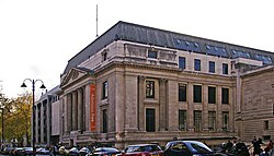
Following the 1851 Great Exhibition in Hyde Park, an 87-acre (35ha) area, west of what is now Exhibition Road, was purchased by the commissioners of the exhibition, in order to create a base for institutions dedicated to the arts and sciences, leading to the foundation of the Royal Albert Hall, three museums, the Royal School of Mines later a world renowned technological university, the Royal College of Music and the Royal College of Organists there. The market gardens of the rural area began to make way for a series of hospitals, such as the Brompton Hospital and the New Cancer Hospital along nearby Fulham Road.[3] Adjacent landowners began to develop the land in the 1860s as a result of the transport hub and the general urbanisation boom west of London, and led to the eventual absorption of Brompton and its station into Kensington. It was sealed by the arrival of the Metropolitan and District Railways at Brompton, but for public relations reasons, it was re-named "South Kensington" in 1868. To facilitate public access to the museums, the railway company built a pedestrian tunnel directly from the station concourse to an exit halfway up Exhibition Road, next to the now defunct Royal Mail sorting office, to avoid crowds having to cross the Cromwell Road.
Since the First World War it has become a cosmopolitan area attracting Belgian and French refugees, but also Poles during the Second World War and after, as well as latterly Spanish, Italian, and American expatriates. Some residents also have a Middle Eastern origin. The French presence is emphasised by the Lycée Français Charles de Gaulle, the French Institute, housing a theatre now used as the Ciné Lumière with nearby the Alliance française, as well as the Consulate General of France, not far from the French Embassy in Knightsbridge.[5] With a French bookshop and many international cafés in the area, it has been called "Paris's 21st arrondissement".[6]
In April and May 1980 a group of six Iranian Arabs entered the Iranian Embassy in South Kensington and took the staff, visitors and a diplomatic policeman hostage. There followed a six-day siege during which one of the hostages was killed. The British SAS finally stormed the building in a 17-minute operation, bringing out the hostages and the one surviving gunman, who was subsequently sentenced to 27 years in prison for his part in the offences.[7]
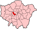
As is often the case in other areas of London, the boundaries for South Kensington are arbitrary and have altered with time. This is due in part to usage arising from the tube stops and other landmarks which developed across Brompton. A contemporary definition is the commercial area around the South Kensington tube station and the adjacent garden squares and streets (such as Onslow Square and Thurloe Square, opposite the Victoria and Albert Museum). To the north is the Kensington Gore, to the south the winding Fulham Road and streets leading to Sloane Square and to the west, the residential and hotel area of Gloucester Road. South Kensington station lies on the junction of several thoroughfares: principally the Old Brompton Road, Harrington Road and Pelham Street and a stone's throw from the arterial Cromwell Road. It is furthermore criss-crossed by the Exhibition Road and the stately Queen's Gate and Prince Consort Road. Until road lay-out improvements in 2012, the area was afflicted with traffic congestion and likened to a series of traffic islands.[8]
The first church to rise among the fields at Brompton was the socially notable, but widely considered architecturally ugly, Holy Trinity Brompton in 1829. It served a wide area from the Kensington Canal in the west to the Kensington Turnpike in the north. The first incumbent, one Percival Frye, just happened to be the nephew of Archdeacon Alfred Pott, vicar of the neighbouring Kensington parish.[1] It was followed by:
Morgan cars, a British family-owned hand built sportscar company, operates a main dealership out of Astwood Mews in South Kensington.
Christie's auction house had a second London salesroom in the Old Brompton Road, South Kensington from 1975, which primarily handled the middle market. Christie's permanently closed the South Kensington salesroom in July 2017 as part of their restructuring plans announced March 2017. The closure was due in part to a considerable decrease in sales between 2015 and 2016 in addition to the company expanding its online presence.[9][10]
Caffè Nero also started life as a single coffee shop in Old Brompton Road, opened by Ian Semp in 1990. It was subsequently bought out and became a chain.[12]
Francis Bacon (1909–1992), Irish-born British artist, lived at 17 Queensberry Mews and 7 Reese Mews.
Charles Booth (1840–1916), pioneer of social research, lived at 6 Grenville Place.
Henry Cole (1808–1882), campaigner, educator and first director of the South Kensington Museum (later the Victoria and Albert Museum), inventor of the Christmas card, lived at 33 Thurloe Square.
Angela Delevingne (1912–2004), socialite, was born in South Kensington
Dennis Gabor (1900–1979), electrical engineer and physicist, most notable for inventing holography, 1971 Nobel Prize in Physics. Lived in No. 79, Queen's Gate.
↑Faucher, Charlotte; Rauch, Olivier; Zuniga, Floriane; Simon, Éric (2015). Le Lycée français Charles de Gaulle de Londres, 1915–2015 (in French). London: Association des anciens de Lycée français de Londres. ISBN978-0-9930-9770-6.
↑Walker, Tim (14 March 2011). "Do bookshops have a future?". The Independent. London. Archived from the original on 24 May 2022. Retrieved 17 January 2012.
This page is based on this Wikipedia article Text is available under the CC BY-SA 4.0 license; additional terms may apply. Images, videos and audio are available under their respective licenses.