The station was opened on 15 December 1906 by the Great Northern, Piccadilly and Brompton Railway (GNP&BR, now the Piccadilly line). When opened, the platforms were accessed in the standard manner by four lifts and an emergency staircase connecting to parallel passageways and bridges to midway along the platforms. The original station building designed by Leslie Green was located on Brompton Road a short distance west of its junction with Knightsbridge and Sloane Street. A rear entrance was located on Basil Street.
The location of the station in a busy and fashionable shopping district meant that patronage at the station was high from the beginning, particularly due to the presence locally of the Harrods and Harvey Nichols emporiums. This contrasted with the next station on the line westward — Brompton Road — where passenger numbers were so low that from soon after its opening many trains were timetabled not to stop there.
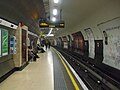
In the early 1930s, the availability of government grants to stimulate the depressed economy enabled the Underground Group to carry out a major modernisation programme, during which many central London stations were brought up to date with escalators to replace the original lifts. Knightsbridge was one of the Piccadilly line stations to benefit from the installation of escalators.
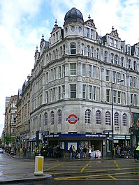
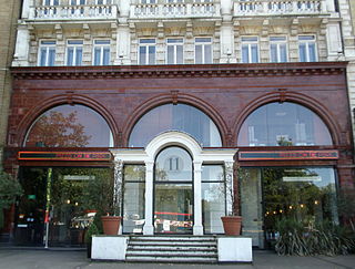
To enable the escalators to reach the existing platforms without excessive below ground reconstruction or interference with station operations a new ticket hall was constructed under the Brompton Road/Knightsbridge/Sloane Street junction and new circulation passages were constructed at the lower level. A new station entrance was inserted into the existing building on the corner of Brompton Road and Sloane Street. Subway entrances on the other corners of the junction enabled pedestrians to avoid the traffic on the busy junction. The original entrances in Brompton Road and Basil Street were closed. The Brompton Road building was subsequently demolished, but the rear entrance at the corner of Basil Street and Hoopers Court remains, although converted for use as offices.
To ease congestion, it was also decided to provide an additional entrance to the western end of the platforms closer to Harrods. The additional exit would further diminish the passenger numbers at Brompton Road so this station was scheduled to close. A separate ticket hall was provided for the western escalators which is accessed by a long subway from the surface entrance at the corner of Hans Crescent. This narrow subway was to be a regular problem, often becoming congested with groups of passengers trying to pass each other in the confined space.
Eventually in 2004, this congestion was solved by the expansion of this exit into a large circular area, under the road towards Harrods, with the way out of the station being by a stairway in the midst of the road.
Early 21st century station upgrades
In recent years, several piecemeal improvements to the station have occurred. The platforms were refurbished in 2005, with the 1930s cream-coloured tiles being concealed behind a modern metal cladding system.[6] In December 2010, a new entrance was opened across the road from the station, as part of the One Hyde Park residential development.[7]
In 2017, a major upgrade to the station was announced, with two new entrances constructed on Brompton Road and Hooper's Court. The new Hooper's Court entrance will have two large lifts, which will allow for step-free access throughout the station.[8] This entrance will also re-open some areas of the station that were closed in the early 1930s when escalators were installed.[9]
Previously expected to open in 2021,[8] the stepped entrance on Brompton Road, which replaced a smaller entrance on the corner of Sloane Street that was becoming unsafe due to overcrowding and a narrow pavement outside, opened in October 2022.[10]As of April2023[update] the step-free entrance in Hoopers Court was expected to open before the end of the year.[11]
Most of the upgrade costs are being paid for by Knightsbridge Estate and developers Chelsfield, who own the property above the station and are responsible for the redevelopment. TfL are contributing £12m, enabling step-free access to be extended to platform level.[12]
In popular culture
The station appeared in a 1992 episode of Rumpole of the Bailey (Rumpole and the Children of the Devil), as Horace Rumpole and his wife Hilda travel there separately from Temple and Gloucester Road stations respectively. They exit Knightsbridge station from the stairs at the former street level portico on the corner of Hans Crescent and Brompton Road, which has since been redeveloped as the main entrance to a Zara fashion shop at 79 Brompton Road.
The opening scene of the 1997 film version of Henry James's The Wings of the Dove was set on the east-bound platforms at both Dover Street and Knightsbridge stations, both represented by the same studio mock-up, complete with a working recreation of a 1906 Stock train.
↑ Transport for London. "Step-free access". Transport for London. Archived from the original on 15 March 2023. Retrieved 6 April 2023. Knightsbridge is going step free in 2023.
New station building, 1934. Compare elevation with current image which shows changes have been made to increase the width of the façade and to the first floor windows
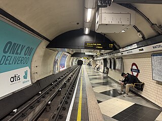
Waterloo is a London Underground station located beneath Waterloo National Rail station. As of 2022, it is the 2nd busiest station on the London Underground, with 68.72 million users. It is served by four lines: Bakerloo, Jubilee, Northern and Waterloo & City.
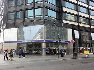
Tottenham Court Road is an interchange station in the West End of London for London Underground and Elizabeth line services.
Arsenal is a London Underground station located in Highbury, London. It is on the Piccadilly line, between Holloway Road and Finsbury Park stations, in Travelcard Zone 2. Originally known as Gillespie Road, it was renamed in 1932 after Arsenal Football Club, who at the time played at the nearby Highbury Stadium. It is the only tube station named directly after a football club. Although Highbury Stadium closed in 2006, the station retains its name and is still used by spectators attending matches at Arsenal's nearby Emirates Stadium.
Finsbury Park is an intermodal interchange station in North London for London Underground, National Rail and London Buses services. The station is the third busiest Underground station outside Zone 1, with over 33 million passengers using the station in 2019.
Leicester Square is a London Underground station in the West End of London, within walking distance of Theatreland and Chinatown. It is located on Charing Cross Road, a short distance to the east of Leicester Square itself.
Piccadilly Circus is a London Underground station located directly beneath Piccadilly Circus itself, with entrances at every corner. Located in Travel-card Zone 1, the station is on the Piccadilly line between Green Park and Leicester Square stations and on the Bakerloo line between Oxford Circus and Charing Cross stations.
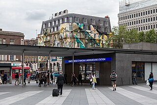
King's Cross St Pancras is a London Underground station on Euston Road in the Borough of Camden, Central London. It serves King's Cross and St Pancras main line stations in fare zone 1, and is an interchange between six Underground lines. The station was one of the first to open on the network. As of 2022, it is the most used station on the network for passenger entrances and exits combined.
Green Park is a London Underground station located on the edge of Green Park, with entrances on both sides of Piccadilly. The station is served by three lines: Jubilee, Piccadilly and Victoria. On the Jubilee line it is between Bond Street and Westminster stations, on the Piccadilly line it is between Hyde Park Corner and Piccadilly Circus stations, and on the Victoria line it is between Victoria and Oxford Circus stations. It is in fare zone 1.
South Kensington is a London Underground station in the district of South Kensington, south west London. It is served by the District, Circle and Piccadilly lines. On the District and Circle lines it is between Gloucester Road and Sloane Square, and on the Piccadilly line between Gloucester Road and Knightsbridge. It is in Travelcard Zone 1. The main station entrance is located at the junction of Old Brompton Road (A3218), Thurloe Place, Harrington Road, Onslow Place and Pelham Street. Subsidiary entrances are located in Exhibition Road giving access by pedestrian tunnel to the Natural History, Science and Victoria and Albert Museums. Also close by are the Royal Albert Hall, Imperial College London, the Royal College of Music, the London branch of the Goethe-Institut and the Ismaili Centre.
Hammersmith is a London Underground station in Hammersmith. It is on the District line between Barons Court and Ravenscourt Park, and on the Piccadilly line between Barons Court and Acton Town or Turnham Green at very early morning and late evening hours. The station is in Travelcard Zone 2.
Earl's Court tube station is a Grade II listed London Underground station in Earl's Court, London, on the District and Piccadilly lines. It is an important interchange for both lines and is situated in both Travelcard Zone 1 and Zone 2. The station has an eastern entrance on Earl's Court Road and a western entrance on Warwick Road. Another former entrance allowed passengers to enter the station from the other side of Warwick Road, via a ticket hall and subway leading to a concourse beneath the District line platforms. Earl's Court is a step-free tube station; the Earls Court Road entrance provides lift access between street and platform levels.
Hyde Park Corner is a London Underground station near Hyde Park Corner in Hyde Park. It is in Travelcard Zone 1, between Knightsbridge and Green Park on the Piccadilly line.
Gloucester Road is a London Underground station in Kensington, west London. The station entrance is located close to the junction of Gloucester Road and Cromwell Road. Close by are the Cromwell Hospital and Baden-Powell House.
Sloane Square is a London Underground station in Chelsea, serving Sloane Square. It is served by the District and Circle lines, between South Kensington and Victoria stations and is in Travelcard Zone 1.
Brompton Road is a disused station on the Piccadilly line of the London Underground, located between Knightsbridge and South Kensington stations.
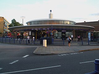
Southgate is a London Underground station in Southgate. It is on the Piccadilly line between Arnos Grove and Oakwood stations and is in Travelcard Zone 4.
Alperton is a London Underground station in Alperton, north-west London. It is on the Uxbridge branch of the Piccadilly line between Sudbury Town and Park Royal stations, in Travelcard Zone 4. It is located on Ealing Road (A4089), a short distance from the junction with Bridgewater Road (A4005), and is close to the Paddington branch of the Grand Union Canal.
Heathrow Terminals 2 & 3 is a London Underground station at Heathrow Airport on the Heathrow branch of the Piccadilly line, which serves Heathrow Terminal 2 and Terminal 3. The station also served Heathrow Terminal 1 until its closure in January 2016. The station is situated in Travelcard Zone 6, along with the nearby Heathrow Terminals 2 & 3 railway station served by Heathrow Express and Elizabeth line services.
Holloway Road is a station on the London Underground. It is on the Piccadilly line between Caledonian Road and Arsenal stations, and in Travelcard Zone 2. The station opened on 15 December 1906.
Paddington is a London Underground station served by the Bakerloo, Circle and District lines. It is located on Praed Street to the south of Paddington mainline station and has entrances from Praed Street and from within the mainline station. On the Bakerloo line the station is between Warwick Avenue and Edgware Road and on the Circle and District lines it is between Bayswater and Edgware Road. It is in London Fare Zone 1.
This page is based on this Wikipedia article Text is available under the CC BY-SA 4.0 license; additional terms may apply. Images, videos and audio are available under their respective licenses.