Holloway Road tube station

Last updated

Holloway Road Underground no-text.svg
Holloway Road stn building02.jpg
Greater London UK location map 2.svg
Red pog.svg
Holloway Road
Location of Holloway Road in Greater London
Location Holloway
Local authority Islington
Managed by London Underground
Number of platforms2
Fare zone 2
London Underground annual entry and exit
2017Increase2.svg 6.79 million [1]
2018Decrease2.svg 6.08 million [2]
2019Increase2.svg 6.69 million [3]
2020Decrease2.svg 2.26 million [4]
2021Increase2.svg 2.88 million [5]
Key dates
15 December 1906Opened
Listed status
Listing gradeII
Entry number1195635 [6]
Added to list17 May 1994;28 years ago (1994-05-17)
Other information
External links
WGS84 51°33′11″N0°06′43″W / 51.55306°N 0.11194°W / 51.55306; -0.11194 Coordinates: 51°33′11″N0°06′43″W / 51.55306°N 0.11194°W / 51.55306; -0.11194
Underground sign at Westminster.jpg  London transportportal

Holloway Road is a station on the London Underground. It is on the Piccadilly line between Caledonian Road and Arsenal stations, and in Travelcard Zone 2. The station opened on 15 December 1906.

Contents

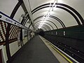
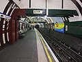
The station was constructed by the Great Northern, Piccadilly and Brompton Railway and was built with two lift shafts, but only one was ever used for lifts. The second shaft was the site of an experimental spiral escalator which was built by the American inventor of escalators, Jesse W. Reno. The experiment was not successful and was never used by the public. In the 1990s, remains of the escalator equipment were excavated from the base of the lift shaft and stored at the London Transport Museum Depot in Acton. From the platforms, a second exit no longer in use is visible and leads to the back of the used lift shaft.

The station is adjacent to the site of the former Holloway and Caledonian Road railway station.

The station is close to the Emirates Stadium, the home of Arsenal football club. As part of the planning permission £5m was due to be spent expanding the current station to cope with increased passenger numbers on match days. However subsequent studies showed that to ensure the station could cope with the numbers the lifts would have to be replaced with escalators which would cost £60m. As a result, the redevelopment plans were put on hold and now at match times the station is exit only, and before a match eastbound trains do not call. [7]

Design

The architect of the station was Leslie Green who built it for the Great Northern, Piccadilly and Brompton Railway (Now part of London Transport) in the Modern Style (British Art Nouveau style). [8] The building is listed by English Heritage as Grade II. [6]

Refurbishment, 2007–2008

Refurbishment works completed in 2008 included the installation of a new public address system, replacement of aging customer information screens, and other aesthetic changes to improve the look, feel and security of the station. This includes improved lighting and a dramatic increase in the number of CCTV cameras.

Lift replacement 2023–24

In May 2023, works to replace the two 1980s lifts started with the work due to take until June 2024, replacing one lift at a time. During Emirates Stadium events the station was closed to prevent overcrowding. [9]

Connections

London Buses routes 21, 43, 153, 263, 393 and night routes N41 and N271 serve the station. [10] [11]

Related Research Articles

<span class="mw-page-title-main">Holborn tube station</span> London Underground station

Holborn is a London Underground station in Holborn, Central London, located at the junction of High Holborn and Kingsway. It is served by the Central and Piccadilly lines. On the Central line the station is between Tottenham Court Road and Chancery Lane stations; on the Piccadilly line it is between Covent Garden and Russell Square and is in Travelcard Zone 1. Close by are the British Museum, Lincoln's Inn Fields, Red Lion Square, Bloomsbury Square, London School of Economics and Sir John Soane's Museum.

<span class="mw-page-title-main">Arsenal tube station</span> London Underground station

Arsenal is a London Underground station located in Highbury, London. It is on the Piccadilly line, between Holloway Road and Finsbury Park stations, in Travelcard Zone 2. Originally known as Gillespie Road, it was renamed in 1932 after Arsenal Football Club, who at the time played at the nearby Highbury Stadium. It is the only tube station named directly after a football club. Although Highbury Stadium closed in 2006, the station retains its name and is still used by spectators attending matches at Arsenal's nearby Emirates Stadium.

<span class="mw-page-title-main">Leicester Square tube station</span> London Underground station

Leicester Square is a London Underground station in the West End of London, within walking distance of Theatreland and Chinatown. It is located on Charing Cross Road, a short distance to the east of Leicester Square itself.

<span class="mw-page-title-main">South Kensington tube station</span> London Underground station

South Kensington is a London Underground station in the district of South Kensington, south west London. It is served by the District, Circle and Piccadilly lines. On the District and Circle lines it is between Gloucester Road and Sloane Square, and on the Piccadilly line between Gloucester Road and Knightsbridge. It is in Travelcard Zone 1. The main station entrance is located at the junction of Old Brompton Road (A3218), Thurloe Place, Harrington Road, Onslow Place and Pelham Street. Subsidiary entrances are located in Exhibition Road giving access by pedestrian tunnel to the Natural History, Science and Victoria and Albert Museums. Also close by are the Royal Albert Hall, Imperial College London, the Royal College of Music, the London branch of the Goethe-Institut and the Ismaili Centre.

<span class="mw-page-title-main">Earl's Court tube station</span> London Underground station

Earl's Court tube station is a Grade II listed London Underground station in Earl's Court, London, on the District and Piccadilly lines. It is an important interchange for both lines and is situated in both Travelcard Zone 1 and Zone 2. The station has an eastern entrance on Earl's Court Road and a western entrance on Warwick Road. Another former entrance allowed passengers to enter the station from the other side of Warwick Road, via a ticket hall and subway leading to a concourse beneath the District line platforms. Earl's Court is a step-free tube station; the Earls Court Road entrance provides lift access between street and platform levels.

<span class="mw-page-title-main">St Paul's tube station</span> London Underground station

St Paul's is a London Underground station located in the City of London financial district. The station, which takes its name from the nearby St Paul's Cathedral, is on the Central line, between Bank and Chancery Lane stations, and is in fare zone 1.

<span class="mw-page-title-main">Chancery Lane tube station</span> London Underground station

Chancery Lane is a London Underground station on the Central Line between Holborn and The City in Central London, England. It has entrances within both the London Borough of Camden and the City of London. It opened in 1900 and takes its name from the nearby Chancery Lane.

<span class="mw-page-title-main">Hyde Park Corner tube station</span> London Underground station

Hyde Park Corner is a London Underground station near Hyde Park Corner in Hyde Park. It is in Travelcard Zone 1, between Knightsbridge and Green Park on the Piccadilly line.

<span class="mw-page-title-main">Gloucester Road tube station</span> London Underground station

Gloucester Road is a London Underground station in Kensington, west London. The station entrance is located close to the junction of Gloucester Road and Cromwell Road. Close by are the Cromwell Hospital and Baden-Powell House.

<span class="mw-page-title-main">Knightsbridge tube station</span> London Underground station

Knightsbridge is a London Underground station in Knightsbridge, London. It is on the Piccadilly line between South Kensington and Hyde Park Corner, and is in Travelcard Zone 1.

<span class="mw-page-title-main">Barons Court tube station</span> London Underground station

Barons Court is a London Underground station in West Kensington in the London Borough of Hammersmith and Fulham, Greater London. This station serves the District line and the Piccadilly line. Barons Court is between West Kensington and Hammersmith on the District line, and between Earl's Court and Hammersmith on the Piccadilly line and is in Travelcard Zone 2. East of the station, the Piccadilly line descends into tunnel towards Earl's Court and the District line continues in a cutting to West Kensington. The station is the last open air stop for eastbound trains on the Piccadilly line until Arnos Grove and has cross-platform interchange with the District line.

<span class="mw-page-title-main">Southgate tube station</span> London Underground station

Southgate is a London Underground Piccadilly line station in Southgate. It is located between Arnos Grove and Oakwood stations and is in Travelcard Zone 4.

<span class="mw-page-title-main">Sudbury Hill tube station</span> London Underground station

Sudbury Hill is a London Underground station on the Uxbridge branch of the Piccadilly line. The station is between Sudbury Town and South Harrow, and is in Travelcard Zone 4. It is located on Greenford Road (A4127) north of the junction with Whitton Avenue, on the border between the London Boroughs of Harrow and Ealing. The station is close to Sudbury Hill Harrow railway station.

<span class="mw-page-title-main">Alperton tube station</span> London Underground station

Alperton is a London Underground station on the Uxbridge branch of the Piccadilly line. The station is between Sudbury Town and Park Royal, in Travelcard Zone 4. It is located on Ealing Road a short distance from the junction with Bridgewater Road (A4005) and is close to Alperton Bus Garage and the Paddington branch of the Grand Union Canal. The station was refurbished in 2006.

<span class="mw-page-title-main">Ealing Common tube station</span> London Underground station

Ealing Common is a London Underground station on the Uxbridge branch of the Piccadilly line and on the Ealing Broadway branch of the District line. Eastbound, the next station is Acton Town; westbound, the next station is North Ealing on the Piccadilly line and Ealing Broadway on the District line. Here, the District and Piccadilly lines share the same pair of tracks through the station – the only other example where a deep level line and a sub surface line share the same pair of tracks is further up the Uxbridge branch, where the Piccadilly line shares tracks with the Metropolitan line from Rayners Lane to Uxbridge. It is the only station west of Acton Town to be served by both the Piccadilly and District lines.

<span class="mw-page-title-main">Heathrow Terminals 2 & 3 tube station</span> London Underground station

Heathrow Terminals 2 & 3 is a London Underground station at Heathrow Airport on the Heathrow branch of the Piccadilly line, which serves Heathrow Terminal 2 and Terminal 3. It was named Heathrow Terminals 1, 2, 3 until January 2016, when Heathrow Terminal 1 was closed. Despite the renaming of the station, the signage on the platform still says Heathrow Terminals 1, 2, 3 as of June 2022. The station is situated in Travelcard Zone 6, along with the nearby Heathrow Terminals 2 & 3 railway station served by Heathrow Express and Elizabeth line services.

<span class="mw-page-title-main">Caledonian Road tube station</span> London Underground station

Caledonian Road is a station on the Piccadilly line of the London Underground, between King's Cross St. Pancras and Holloway Road, and in Travelcard Zone 2. It was opened on 15 December 1906 by the Great Northern, Piccadilly and Brompton Railway. The building was designed by Leslie Green.

<span class="mw-page-title-main">Hillingdon tube station</span> London Underground station

Hillingdon tube station is a London Underground station in North Hillingdon in the London Borough of Hillingdon, West London. Located between Uxbridge and Ickenham, it is in Travelcard Zone 6. It is the penultimate station on the Uxbridge branch of both the Metropolitan line and the Piccadilly line. Resited in 1992, it is also the most recently constructed station on the Metropolitan line.

<span class="mw-page-title-main">North Ealing tube station</span> London Underground station

North Ealing is a London Underground station on the Uxbridge branch of the Piccadilly line between Ealing Common and Park Royal. The station is located on Station Road, a short distance from the junction of Queen's Drive and Hanger Lane. It is in Travelcard Zone 3. West Acton station on the Central line is located about 550 metres to the east at the other end of Queen's Drive.

<span class="mw-page-title-main">Stamford Brook tube station</span> London Underground station

Stamford Brook is a London Underground station on the eastern edge of Chiswick in west London. The station is served by the District line and is between Ravenscourt Park and Turnham Green stations. The main entrance is located on Goldhawk Road (A402) with a secondary entrance on Prebend Gardens. It is in Travelcard Zone 2. The station takes its name from Stamford Brook, a tributary of the River Thames that is now predominantly underground. The Piccadilly line uses the inside tracks, but does not stop here except on rare occasions

References

  1. "Multi-year station entry-and-exit figures (2007–2017)". London Underground station passenger usage data. Transport for London. January 2018. Archived from the original (XLSX) on 31 July 2018. Retrieved 22 July 2018.
  2. "Station Usage Data" (CSV). Usage Statistics for London Stations, 2018. Transport for London. 21 August 2019. Archived from the original on 22 May 2020. Retrieved 27 April 2020.
  3. "Station Usage Data" (XLSX). Usage Statistics for London Stations, 2019. Transport for London. 23 September 2020. Archived from the original on 9 November 2020. Retrieved 9 November 2020.
  4. "Station Usage Data" (XLSX). Usage Statistics for London Stations, 2020. Transport for London. 16 April 2021. Retrieved 1 January 2022.
  5. "Station Usage Data" (XLSX). Usage Statistics for London Stations, 2021. Transport for London. 12 July 2022. Retrieved 7 September 2022.
  6. 1 2 Historic England. "Holloway Road Station (London Transport) (1195635)". National Heritage List for England . Retrieved 3 April 2015.
  7. "Get to... Emirates Stadium – Matchday arrangements". arsenal.com. Arsenal Broadband Limited. 2011. Archived from the original on 12 August 2008.
  8. "London Underground by Design by Mark Ovenden – review". TheGuardian.com . 3 February 2013.
  9. "Reduced access to Holloway Road tube station for a year while lifts are replaced". ianVisits. 11 May 2023.
  10. "Buses from Arsenal (Emirates Stadium)" (PDF). TfL. 4 February 2023. Retrieved 5 February 2023.
  11. "Night buses from Arsenal (Emirates Stadium)" (PDF). TfL. 4 February 2023. Retrieved 5 February 2023.
Preceding station Underground no-text.svg London Underground Following station
Caledonian Road Piccadilly line Arsenal