
The Royal Borough of Kensington and Chelsea is an Inner London borough with royal status. It is the smallest borough in London and the second smallest district in England; it is one of the most densely populated administrative regions in the United Kingdom. It includes affluent areas such as Notting Hill, Kensington, South Kensington, Chelsea, and Knightsbridge.

The London Borough of Hammersmith and Fulham is a London borough in West London and which also forms part of Inner London. The borough was formed in 1965 as the London Borough of Hammersmith from the merger of the former Metropolitan Boroughs of Fulham and Hammersmith. The name was changed to Hammersmith and Fulham in 1979. The borough borders Brent to the north, the Royal Borough of Kensington and Chelsea to the east, Wandsworth to the south, Richmond upon Thames to the south west, and Hounslow and Ealing to the west.

Fulham is an area of the London Borough of Hammersmith & Fulham in West London, England, 3.6 miles (5.8 km) southwest of Charing Cross. It lies on the north bank of the River Thames, bordering Hammersmith, Kensington and Chelsea. The area faces Wandsworth, Putney, Barn Elms and the London Wetland Centre in Barnes. on the far side of the river.

Chelsea is an affluent area in West London, England, due south-west of Charing Cross by approximately 2.5 miles. It lies on the north bank of the River Thames and for postal purposes is part of the south-western postal area.
King's Road or Kings Road is a major street stretching through Chelsea and Fulham, both in west London, England. It is associated with 1960s style and with fashion figures such as Mary Quant and Vivienne Westwood. Sir Oswald Mosley's Blackshirt movement had a barracks on the street in the 1930s.

Putney Bridge is a London Underground station on the Wimbledon branch of the District line. It is between Parsons Green and East Putney stations and is in Zone 2. The station is located in the south of Fulham, adjacent to Fulham High Street and New Kings Road (A308) and is a short distance from the north end of Putney Bridge from which it takes its name.
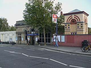
West Brompton is a station located on Old Brompton Road (A3218) in West Brompton, West London for London Underground, London Overground and National Rail services. It is immediately south of the demolished Earls Court Exhibition Centre and west of Brompton Cemetery in the Royal Borough of Kensington and Chelsea.
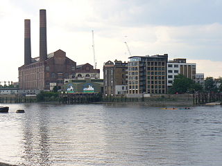
Counter's Creek, ending in Chelsea Creek, the lowest part of which still exists, was a stream that flowed from Kensal Green, by North Kensington and flowed south into the River Thames on the Tideway at Sands End, Fulham. Its remaining open watercourse is the quay of Chelsea Creek.
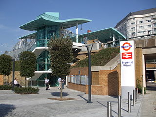
Imperial Wharf is a station located in Sands End in West London for London Overground and National Rail services.
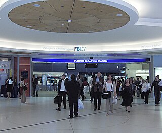
Fulham Broadway is a London Underground station on the Wimbledon branch of the District line. It is between West Brompton and Parsons Green stations and is in Travelcard Zone 2. The station is located on Fulham Broadway (A304). It is the nearest station to Stamford Bridge stadium, the home of Chelsea Football Club. The station is in a cutting that was originally open air until it was covered by the 'Fulham Broadway Shopping Centre' development. The line then resurfaces shortly before West Brompton station.

Brompton Road is a street located in the southern part from Knightsbridge and in the eastern part from Brompton in the Royal Borough of Kensington and Chelsea and partly the City of Westminster in London.

West Kensington, formerly North End, is an area in the ancient parish of Fulham, in the London Borough of Hammersmith and Fulham, England, 3.4 miles (5.5 km) west of Charing Cross. It covers most of the London postal area of W14, including the area around Barons Court tube station, and is defined as the area between Lillie Road and Hammersmith Road to the west, Fulham Palace Road to the south, Hammersmith to the north and West Brompton and Earl's Court to the east. The area is bisected by the major London artery the A4, locally known as the Talgarth Road. Its main local thoroughfare is the North End Road.

The A308 is a road in England in two parts. The first part runs from Central London to Putney Bridge. The second part runs from just beyond Putney Heath to Bisham, Berkshire. It traces four, roughly straight lines, to stay no more than 3 miles (4.8 km) from the Thames. It is a dual carriageway where it is furthest from that river, in Spelthorne, Surrey and forms one of the motorway spurs to the large town of Maidenhead. Other key settlements served are Fulham, Kingston (London), Staines upon Thames, Windsor and a minor approach to Marlow

Brompton, sometimes called Old Brompton, survives in name as a ward in the Royal Borough of Kensington and Chelsea in London. Until the latter half of the 19th century it was a scattered village made up mostly of market gardens in the county of Middlesex. It lay southeast of the village of Kensington, abutting the parish of St Margaret's, Westminster at the hamlet of Knightsbridge to the northeast, with Little Chelsea to the south. It was bisected by the Fulham Turnpike, the main road westward out of London to the ancient parish of Fulham and on to Putney and Surrey. It saw its first parish church, Holy Trinity Brompton, only in 1829. Today the village has been comprehensively eclipsed by segmentation due principally to railway development culminating in London Underground lines, and its imposition of station names, including Knightsbridge, South Kensington and Gloucester Road as the names of stops during accelerated urbanisation, but lacking any cogent reference to local history and usage or distinctions from neighbouring settlements.

Chelsea and Fulham is a constituency in Greater London represented in the House of Commons of the UK Parliament by Ben Coleman of the Labour Party.

West Brompton is an area of west London, England, that straddles the boundary between the London Borough of Hammersmith and Fulham and Royal Borough of Kensington and Chelsea. The centuries-old boundary was traced by Counter's Creek, now lost beneath the West London Line railway.

Walham Green is the historic name of an English village, now part of inner London, in the parish of Fulham in the County of Middlesex. It was located between the hamlet of North End to the north, and Parsons Green to the south. To the east it was bounded by Counter's Creek, the historical boundary with the parish of Chelsea, and to the south-east is Sands End.

Lillie Bridge is a road bridge that links Old Brompton Road in the Royal Borough of Kensington and Chelsea with Lillie Road in the London Borough of Hammersmith & Fulham. It crosses two railways: the West London Line on the London Overground and the Wimbledon branch of the London Underground at West Brompton station.

Dovehouse Street is a street in Chelsea, London. It runs roughly north to south from Fulham Road to King's Road, having junctions with Cale Street and Britten Street, among others.
