A31 | ||||
---|---|---|---|---|
Route information | ||||
Length | 72.6 mi (116.8 km) | |||
Northeast segment | ||||
Length | 36.6 mi [1] (58.9 km) | |||
Northeast end | A322 in Guildford | |||
Major intersections | A3 near Guildford A331 near Tongham A33 in Winchester | |||
Southwest end | M3 in Winchester | |||
Southwest | ||||
Length | 36.0 mi [2] (57.9 km) | |||
Northeast end | A36 near Netley Marsh | |||
Major intersections | M27 in Cadnam A338 in Ringwood A348 in West Moors A350 near Sturminster Marshall | |||
Southwest end | A35 in Bere Regis | |||
Location | ||||
Country | United Kingdom | |||
Counties | Surrey, Hampshire, Dorset | |||
Primary destinations | Winchester Farnham Ringwood | |||
Road network | ||||
|
The A31 is a major trunk road in southern England that runs from Guildford in Surrey to Bere Regis in Dorset. Its best-known section is the Hog's Back, a ridge forming part of the North Downs between Guildford and Farnham in Surrey.
The road begins near Guildford station at the start of Farnham Road, coming out of the town and passing over the A3, shortly after becoming a dual carriageway running west along the Hog's Back escarpment of the North Downs. This dual carriageway section has a speed limit of 60 mph. At Tongham it leaves the older Hog's Back route to join the A331 and follow a modern bypass round Farnham, rejoining the older route at the roundabout junction with the A325 where it follows Alton Road toward Alton which it bypasses, rejoining the older route near Jane Austen's house, then continuing to Alresford before joining the route of the M3 motorway at its junction on the eastern boundary of Winchester.
The old route to Winchester's centre then Romsey and the New Forest forms two roads: the B3404 and A3090 roads and is marked for cyclists. The west branch of the M27 motorway – M3 interchange has a flyover junction with the winding westbound A3090 on the western boundary of Cadnam, having passed through the conservation area village centre, from where the resumed A31 continues as a dualled trunk road through the rest of the New Forest, past Ringwood and enters Dorset just before it passes Ferndown where it resumes single carriageway width. It passes Wimborne Minster and by-passes Charborough Park before terminating at a roundabout junction with the A35 road at Bere Regis. The A35 is not a trunk road east of Bere Regis, but is a continuation of the A31 trunk road to the west, thus the Highways Agency maintain it.
The A31 is part of the ancient route from London to Winchester.
The A31 between Wimborne Minster and Bere Regis: most of its Dorset stretch is primarily a single-carriageway road, used by heavy goods vehicles, and as such is relatively slow for a trunk road during busy times of the day. However the River Stour is one of the most flood-prone rivers alongside in the region and a widened road would accelerate drainage and disrupt views of the valley from Areas of Outstanding Beauty on the escarpments to the north.
Many sections of the A31 were upgraded to dual carriageway in the 1960s, except for the section of road running through the New Forest. [3]
The upgrade of the A31 through the New Forest started in the early 1960s, following two decades of debate. The Government's intention was to create at least one high-speed route to the south coast, while the guardians of the forest, the Verderers, resisted any further development. [4] [5]
The first section of the A31 to be dualled was the section that the M27 feeds into at Jct1; the westbound carriageway is the original two-way A-road while the eastbound side was laid down nearby. Further developments occurred from Ringwood to Picket Post near the turn-off for Burley. From 1966 to 1972, the remaining sections were completed rapidly due to the construction of the M27 motorway up to Jct 1. [6]
The Highways Agency declares the New Forest A31 section as being 'an abnormal and heavy load route'. [7] The westbound route, particularly, suffers from poor horizontal and vertical alignment due to its original function as an old single carriageway. The Highways Agency's route management strategy (RMS) for the A31 has identified that the westbound carriageway needs realigning at Cadnam where it undulates rapidly before negotiating a sharp right turn and passes an at-grade U-turn box, though there is no timetable for this at present. There is also a pinch point at Ringwood where the A31 interplexes with the A338; the section of road was widened to four lanes each way for the duration of the A338 interplex (following the upgrade of the Ashley Heath Junction to Bournemouth in the early 1990s) but a short section where westbound A338 traffic joins westbound A31 was left with 2 lanes, and previously the lack of capacity at this section caused safety problems and queues at peak times. Dorset County Council cited relieving this junction as a high priority in the Bournemouth LTP 2006–2011. [8] In December 2014 the Government announced a series of schemes as part of a £15bn investment in transport infrastructure that included widening the Westbound carriageway to 3 lanes. [9] Work to widen the westbound section to 3 lanes began in January 2022 in conjunction with a wider scheme improving safety, and replacing two bridges over the River Avon and Bickerley Millstream. The widening scheme was completed in November 2022. [10] [11] A Highways Agency review in 2010 records that the collision rate between the A338 Ringwood junction and the Poulner Hill Interchange was 4.5 Personal Injury Collisions (PICs) per 100million vehicle kilometers, whilst the rate for the stretch between Poulner Hill and Picket Post is 11.7 PICs per 100million vehicle kilometers.
This section of road is single carriageway for its entire length, a long section around Winterborne Zelston has a 40 mph speed limit, and occasionally has mobile speed cameras in place.
There are no good overtaking places on this stretch of road due to its narrow, twisty nature. There are three long straight sections of road along Charborough Park, at the end of each straight there is blind bend. Due to the lack of alternative overtaking places traffic use this stretch of road to overtake, but due to the blind bends this sometimes results in head-on collisions between vehicles. The 6 ft wall that runs alongside the road has many holes, and repaired sections which have been hit by cars over the years.
The A31 crosses the A350 at a large roundabout. Due to the volume of traffic crossing this roundabout on both the A350 and A31, clear lane markings have been added to ease congestion.
Sections along the A31 have been widened or straightened and junctions enhanced, particularly as the population of the main towns in Dorset has expanded.
Location | Hampshire |
---|---|
Length | 19 mi (31 km) |
A section of the A31 between Winchester and Ower in Hampshire is now known as the A3090.
Prior to completion of the M3 past Winchester in 1995, the A3090 ran south west from the A33 at Kings Worthy (where the A33 diverted around the Winchester Bypass) to the centre of Winchester, before continuing along the historic route of the A31 from Winchester to Hursley. Here it ended at a junction with the A31, which at this time, having merged with the by-pass east of Winchester, re-emerged from the A33 at Otterbourne and ran to Hursley and on along the current route of the A3090. [12]
A short dual carriageway section starts from the A36 roundabout near Ower and terminates just before the A27 multiplex south west of Romsey.
A short stretch of the original A31 immediately to the east of Winchester is now by-passed and renumbered as the B3404. The old route commences at a roundabout at Morn Hill, and continues straight across the top of Magdalen Hill Down before crossing over the M3 motorway and A272 road on an overbridge and then descending the steep street of Magdalen Hill into the centre of Winchester. [13]
County | Location | mi [1] | km | Destinations | Notes |
---|---|---|---|---|---|
Surrey | Guildford | 0.0 | 0.0 | A322 to A3 / M25 / A281 – Bagshot, London, Horsham | North-eastern terminus |
Guildford–Compton boundary | 2.2 | 3.5 | A3 north-east to M25 / A25 – London, Esher, Dorking | Junction; north-east exit and south-west entrance | |
Wanborough | 3.6 | 5.8 | B3000 to A3 south-west – Portsmouth, Godalming, Normandy, Compton, Puttenham, Wanborough | Junction | |
Tongham–Farnham boundary | 6.9– 7.5 | 11.1– 12.1 | A331 north to M3 / A3011 / A324 / A323 – Camberley, Farnborough, Woking, Aldershot | Junction; southern terminus of A331 | |
Farnham | 8.8– 9.2 | 14.2– 14.8 | A325 north-east / Guildford Road to A3016 – Odiham, Badshot Lea, Central Farnham | North-eastern terminus of A325 concurrency | |
10.8 | 17.4 | A325 south-west / West Street – Petersfield, Wrecclesham, Central Farnham | South-western terminus of A325 concurrency | ||
Hampshire | Alton–Chawton boundary | 19.8– 20.2 | 31.9– 32.5 | A339 north / B3006 to B3349 – Basingstoke, Alton, Liss, Selborne, Odiham | Junction; southern terminus of A339 |
Chawton | 20.8 | 33.5 | A32 south (Gosport Road) / Winchester Road / Northfield Lane to A272 – Fareham, Petersfield, Droxford, West Meon, Farringdon, Chawton | Northern terminus of A32 | |
Chilcomb | 34.4 | 55.4 | A272 east – Petersfield, Bramdean, Cheriton | No access from A31 north-east to A272 east; north-eastern terminus of A272 concurrency | |
Winchester | 35.7 | 57.5 | A33 north to M3 / A34 / A303 / A30 – Basingstoke, Newbury, Andover, Salisbury, Winnall, Kings Worthy, Stockbridge | Southern terminus of A33 | |
36.3– 36.6 | 58.4– 58.9 | M3 south to M27 – Southampton, Portsmouth, Bournemouth, Eastleigh, Romsey Bar End Road / Bull Drove – Winchester city centre | Western terminus of eastern segment; no access to M3 north or from M3 south to A31; south-western terminus of A272 concurrency | ||
1.000 mi = 1.609 km; 1.000 km = 0.621 mi |
County | Location | mi [2] | km | Destinations | Notes |
---|---|---|---|---|---|
Hampshire | Netley Marsh | 0.0 | 0.0 | A36 (Salisbury Road) to A3090 – Salisbury, Calmore, Totton, Romsey | North-eastern terminus |
Cadnam | 2.5 | 4.0 | A336 east / A337 south – Cadnam, Totton, Lyndhurst, Lymington, Bartley, Netley Marsh, Minstead | Western terminus of A336; northern terminus of A337 | |
Copythorne–Minstead boundary | 2.9 | 4.7 | M27 east / B3079 – London, Southampton, Winchester, Brook, Bramshaw, Fordingbridge, Fritham, Bolderwood, Linwood | Western terminus of A27; A27 junction 1 | |
Picket Post | 10.6– 11.0 | 17.1– 17.7 | Burley | Junction | |
Ringwood | 12.4– 12.8 | 20.0– 20.6 | Hightown, Poulner, Crow | Junction; Crow signed north-east only | |
13.4– 13.8 | 21.6– 22.2 | A338 north / B3347 – Salisbury, Fordingbridge, Ringwood | North-eastern terminus of A338 concurrency | ||
Dorset | St Ives | 14.2– 14.5 | 22.9– 23.3 | B3081 – Verwood | Junction |
14.5– 15.1 | 23.3– 24.3 | A338 south to B3073 – Bournemouth, Christchurch, Ashley Heath, Three Legged Cross, Horton | To B3073 signed eastbound only; junction; south-western terminus of A338 concurrency | ||
Ferndown–West Moors boundary | 19.0 | 30.6 | A348 south-west to A347 – Bournemouth, Ferndown, West Parley, Longham | North-eastern terminus of A348 | |
19.6– 19.9 | 31.5– 32.0 | B3072 – West Moors, Verwood, Ferndown | Junction | ||
Broadstone | 24.5 | 39.4 | A349 south / Merley House Lane to B3073 / A341 – Poole, Bournemouth, Broadstone, Merley, Canford Magna | Northern terminus of A349 | |
Sturminster Marshall–Lytchett Matravers boundary | 28.8 | 46.3 | A350 (Poole Road) – Poole, Bournemouth, Wareham, Blandford, Lytchett Matravers, Upton, Sturminster Marshall | Sturminster Marshall signed north-east only | |
Bere Regis | 36.0 | 57.9 | A35 / North Street – Poole, Bournemouth, Dorchester, Wool, Bere Regis, Weymouth, Puddletown, Tolpuddle | South-western terminus | |
1.000 mi = 1.609 km; 1.000 km = 0.621 mi |
The A3, known as the Portsmouth Road or London Road in sections, is a major road connecting the City of London and Portsmouth passing close to Kingston upon Thames, Guildford, Haslemere and Petersfield. For much of its 67-mile (108 km) length, it is classified as a trunk road and therefore managed by National Highways. Almost all of the road has been built to dual carriageway standards or wider. Apart from bypass sections in London, the road travels in a southwest direction and, after Liss, south-southwest.
The M1 motorway connects London to Leeds, where it joins the A1(M) near Aberford, to connect to Newcastle. It was the first inter-urban motorway to be completed in the UK; the first motorway in the country was the Preston Bypass, which later became part of the M6.
The A1, also known as the Great North Road, is the longest numbered road in the United Kingdom, at 410 miles (660 km). It connects London, the capital of England, with Edinburgh, the capital of Scotland. The numbering system for A-roads, devised in the early 1920s, was based around patterns of roads radiating from two hubs at London and Edinburgh. The first number in the system, A1, was given to the most important part of that system: the road from London to Edinburgh, joining the two central points of the system and linking the UK's (then) two mainland capital cities. It passes through or near north London, Hatfield, Welwyn Garden City, Stevenage, Baldock, Letchworth Garden City, Biggleswade, Eaton Socon, Buckden, Peterborough, Stamford, Grantham, Newark-on-Trent, Retford, Doncaster, Pontefract, York, Wetherby, Ripon, Darlington, Durham, Gateshead, Newcastle upon Tyne, Morpeth, Alnwick and Berwick-upon-Tweed.
The M40 motorway links London, Oxford, and Birmingham in England, a distance of approximately 89 miles (143 km).
The M3 is a motorway in England, from Sunbury-on-Thames, Surrey, to Eastleigh, Hampshire; a distance of approximately 59 miles (95 km). The route includes the Aldershot Urban Area, Basingstoke, Winchester, and Southampton.
The M27 is a motorway in Hampshire, England. It is 27.9 miles (44.9 km) long and runs between Cadnam and Portsmouth. It was opened in stages between 1975 and 1983, providing the largest two urban areas in Hampshire with a direct motorway link. An extension into the county of West Sussex was planned but never constructed. A number of smaller motorways were proposed, connecting the city centres of Southampton and Portsmouth to the motorway; of these only the M271 and M275 were built. Three sections of the M27 have since been widened to four lanes each way, the first between junctions 7 and 8, the second between junctions 3 and 4, and the third begins at the slip road where junction 11 joins until mid-way to junction 12.
The A36 is a trunk road and primary route in southwest England that links the port city of Southampton to the city of Bath. At Bath, the A36 connects with the A4 to Bristol, thus providing a road link between the major ports of Southampton and Bristol. It also provides a link between Bristol and London via the A303.
The A11 is a major trunk road in England. It originally ran roughly north east from London to Norwich, Norfolk. It now consists of a short section in Inner London and a much longer section in Cambridgeshire, Suffolk and Norfolk. The lengthy section between these was renumbered as a result of the opening of the M11 in the 1970s and then the A12 extension in 1999.
The A27 is a major road in England. It runs from its junction with the A36 at Whiteparish in the county of Wiltshire, follows the south coast of Hampshire and West Sussex, and terminates at Pevensey in East Sussex.
The A35 is a major road in southern England, connecting Honiton in Devon and Southampton in Hampshire. It is a trunk road for some of its length. Most of its route passes through Dorset and the New Forest. It originally connected Exeter and Southampton, the original A35 ran along what is now the A3052 joining the present road at Charmouth.
The A33 is a major road in the counties of Berkshire and Hampshire in southern England. The road currently runs in three disjoint sections.
The A272 is a road in southeast England. It follows an approximate east–west route from near Heathfield, East Sussex to the city of Winchester, Hampshire.
The A350 is a north–south primary route in southern England, that runs from the M4 motorway in Wiltshire to Poole in Dorset.
The A453 road was formerly the main trunk road connecting the English cities of Nottingham and Birmingham. However, the middle section of this mainly single-carriageway road has largely been downgraded to B roads or unclassified roads following the construction of the parallel M42-A42 link around 1990. The M42 was originally meant to pass further north than it does, and to join the M1 at Sandiacre in Derbyshire. The M42/A42 does not enter Derbyshire, but instead joins the M1 closer to the A453 junction at Kegworth. The A42 shadows the former A453 from Appleby Magna to Castle Donington. The road historically connected the East Midlands with the West Midlands.
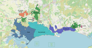
The South East Dorset conurbation is a multi-centred conurbation on the south coast of Dorset in England.
The A249 is a road in Kent, England, running from Maidstone to Sheerness on the Isle of Sheppey. It mainly functions as a link between the M2 and M20 motorways, and for goods vehicle traffic to the port at Sheerness.
The A338 is a major primary route in southern England, that runs from the junction with the A35 at Poole in Dorset to the junction with the A420 at Besselsleigh in Oxfordshire, a distance of 84 miles (135 km).
Dorset is a county in South West England. The county is largely rural and therefore does not have a dense transport network, and is one of the few English counties without a motorway. Owing to its position on the English Channel coast, and its natural sheltered harbours, it has a maritime history, though lack of inland transport routes has led to the decline of its ports.
The A174 is a major road in North Yorkshire, England. It runs from the A19 road at Thornaby-on-Tees, across South Teesside and down the Yorkshire Coast to Whitby. The A174 is the coastal route between Teesside and Whitby; the alternative road, the A171, is described as being the moorland route.
Picket Post is a road junction and service area in the New Forest National Park of Hampshire, England. It lies on the A31 road.