
Dartmouth is a town and civil parish in the English county of Devon. It is a tourist destination set on the western bank of the estuary of the River Dart, which is a long narrow tidal ria that runs inland as far as Totnes. It lies within the South Devon Area of Outstanding Natural Beauty and South Hams district, and had a population of 5,512 in 2001, reducing to 5,064 at the 2011 census. There are two electoral wards in the Dartmouth area. Their combined population at the above census was 6,822.
Kingsbridge is a market town and tourist hub in the South Hams district of Devon, England, with a population of 6,116 at the 2011 census. Two electoral wards bear the name of Kingsbridge. Their combined population at the above census was 4,381. It is situated at the northern end of the Kingsbridge Estuary, a ria that extends to the sea six miles south of the town. It is the third largest settlement in the South Hams and is 17 miles (27 km) southwest of Torquay and 17 miles (27 km) southeast of Plymouth.

South Hams is a local government district on the south coast of Devon, England. Services divide between those provided by its own Council headquartered in Totnes, and those provided by Devon County Council headquartered in the city of Exeter.

The River Teign is a river in the county of Devon, England. It is 31 mi (50 km) long and rises on Dartmoor, becomes an estuary just below Newton Abbot and reaches the English Channel at Teignmouth.

Newton Abbot is a market town and civil parish on the River Teign in the Teignbridge District of Devon, England. Its 2011 population of 24,029 was estimated to reach 26,655 in 2019. It grew rapidly in the Victorian era as the home of the South Devon Railway locomotive works. This later became a major steam engine shed, retained to service British Railways diesel locomotives until 1981. It now houses the Brunel industrial estate. The town has a race course nearby, the most westerly in England, and a country park, Decoy. It is twinned with Besigheim in Germany and Ay in France.

Totnes is a parliamentary constituency in Devon represented in the House of Commons of the UK Parliament since December 2019 by Anthony Mangnall, a Conservative. Mangnall defeated incumbent Sarah Wollaston who had originally been elected as a Conservative but defected to the Liberal Democrats earlier that year.

Teignbridge was, from 1983 until 2010, a county constituency represented in the House of Commons of the Parliament of the United Kingdom. It elected one Member of Parliament (MP) by the first past the post system of election.

Kingsteignton, is a town and civil parish in South Devon, England. It lies at the head of the Teign Estuary to the west of Teignmouth in the Teignbridge district. It is bypassed by the A380 and is also on the A383, A381, B3193 and B3195. Kingsteignton is currently represented in parliament by Anne Marie Morris, as part of the Newton Abbot Constituency.The local education centers (schools) include : Rydon Primary School, Teign School and Saint Michael's School Church of England School.

South Hams was a county constituency based on the South Hams district of Devon. It returned one Member of Parliament (MP) to the House of Commons of the Parliament of the United Kingdom. The constituency was created for the 1983 general election, and abolished for the 1997 general election. The constituency covered a vast part of the English Riviera on the south Devon coast.
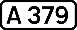
The A379 is a road in the English county of Devon. It links points on the edges of that county's two principal cities, Exeter and Plymouth, by an indirect and largely coastal route. The A38 provides a faster and more direct inland route between Exeter and Plymouth, whilst the A380 provides a similarly faster route between Exeter and the Torbay area. However the A379 serves many small coastal communities and ports along the coast. The indented nature of the South Devon coast means that the road is usually out of sight of the sea, but the many rivers and estuaries are crossed by bridges and, in one case, a cable ferry.

The A380 is a road in South West England, connecting the Torbay area to the A38, and hence to the rest of Great Britain's main road network.
The South Devon Railway Company built and operated the railway from Exeter to Plymouth and Torquay in Devon, England. It was a 7 ft 1⁄4 in broad gauge railway built by Isambard Kingdom Brunel.

The South Devon Area of Outstanding Natural Beauty (AONB) covers 337 square kilometres, including much of the South Hams area of Devon and the rugged coastline from Jennycliff Bay to Elberry Cove near Brixham. The purpose of an Area of Outstanding Natural Beauty is to conserve and enhance the area's natural beauty. In South Devon this includes: undeveloped coastline, estuaries, geological and geomorphological features, expansive panoramic views, ancient agricultural field pattern, Devon banks, areas of high tranquility, dark night skies and natural nightscapes, historic features, green lanes, well known cultural associations, picturesque villages and hamlets. South Devon AONB was formally designated in August 1960 under the National Parks and Access to the Countryside Act 1949. The highest point in the AONB is Blackdown Camp at 199 metres above sea level.

The Hackney Canal was a short canal in Devon, England, that linked the Hackney Clay Cellars to the River Teign. It was privately built by Lord Clifford in 1843, and throughout its life carried ball clay for use in the production of pottery. It closed in 1928, when its function was replaced by road vehicles.
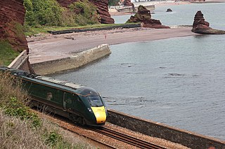
The Exeter–Plymouth line, also called the South Devon Main Line, is a central part of the trunk railway line between London Paddington and Penzance in the southern United Kingdom. It is a major branch of the Great Western Main Line and runs from Exeter St Davids to Plymouth, from where it continues as the Cornish Main Line. It was one of the principal routes of the Great Western Railway which in 1948 became part of the Western Region of British Railways and are now part of the Network Rail system.
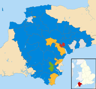
The 2017 Devon County Council election took place on 4 May 2017 as part of the 2017 local elections in the United Kingdom. All 60 councillors were elected from 58 electoral divisions, which returned either one or two county councillors each by first-past-the-post voting for a four-year term of office.


