Kingsbridge is a market town in the South Hams district of Devon, England, with a population of 6,116 at the 2011 census.[2] Two electoral wards bear the name of Kingsbridge (East & North). Their combined population at the above census was 4,381.[3][4] It is situated at the northern end of the Kingsbridge Estuary, a ria that extends to the sea six miles (10km) south of the town. It is the third largest settlement in the South Hams and is 17 miles (27km) southwest of Torquay and 17 miles (27km) southeast of Plymouth.
The town formed around a bridge which was built in or before the 10th century between the royal estates of Alvington, to the west, and Chillington, to the east, hence giving it the name of Kyngysbrygge ("King's bridge"). In 1219[5][6] the Abbot of Buckfast was granted the right to hold a market there, and by 1238 the settlement had become a borough.[5] The manor remained in possession of the abbot until the Dissolution of the Monasteries, when it was granted to Sir William Petre. Kingsbridge was never represented in Parliament or incorporated by charter, the local government being by a portreeve. It lay within the hundred of Stanborough.[7]
Kingsbridge is, in fact, a combination of two towns, Kingsbridge and Dodbrooke. Dodbrooke was granted its own market in 1257 and had become a borough by 1319. While Dodbrooke was originally considered to be the dominant of the two, Kingsbridge later expanded to include it. The town consists of two ecclesiastical parishes: St. Edmund's in the west and St. Thomas Becket at Dodbrooke in the east. St. Edmund's Church, in mainly Perpendicular style, retains some 13th-century features including a font, but was enlarged and reconsecrated around 1414 and was mostly rebuilt in the 19th century. The parish church of St. Thomas Becket displays a particularly well-preserved rood screen, restored in 1897.
A map of the town was drawn up in 1586 recording land belonging to Sir John Petre.[8]
In 1798 the town mills were converted into a woollen manufactory, which produced large quantities of cloth, and serge manufacture was introduced early in the 19th century. During the 19th century the town had an active coastal shipping trade, shipbuilding, a tannery, other industries and a large monthly cattle market. The chief exports were cider, corn, malt, and slate.[7]
Kingsbridge was used by Anthony Trollope as the setting for his novel Rachel Ray (1863)[9] and by Rachel Joyce as the setting for her 2012 novel The Unlikely Pilgrimage of Harold Fry. In October 2021 Embankment Films started filming in Kingsbridge for the big screen version of The Unlikely Pilgrimage of Harold Fry, starring Jim Broadbent, Penelope Wilton, Monika Gossmann and Bethan Cullinane. The film was released in April 2023.
The town centre retains many 18th and 19th century buildings. The Shambles, or market arcade, was rebuilt in 1796 but retains its 16th century granite piers. The former grammar school, now a museum, was founded and built by Thomas Crispin in 1670.[5]
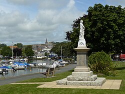
Modern day
View of the town over the estuary
Kingsbridge has been the main market town in the area for centuries. Being situated within the South Devon Area of Outstanding Natural Beauty (AONB) and with its proximity to the south Devon coast and sailing venues such as Salcombe and Hope Cove, the town has developed into a popular tourist destination. Its attractions include several restaurants, pubs, a cinema housed in the old Kingsbridge Town Hall building, and a museum devoted to the chemist William Cookworthy who was born in the town in 1705.[10]
There are two supermarkets in Kingsbridge: a Morrisons and a Tesco Store, which opened in 2010. It also has a large secondary school, Kingsbridge Community College, which has over 1,000 pupils and serves the surrounding area. Kingsbridge was home to "the only nightclub in the South Hams", Coast (which has since closed), with the next nearest club being in Torquay.[11]
The town is linked to Plymouth and Dartmouth by the A379 road, and to Salcombe and Totnes by the A381. For seventy years it had a railway station until the branch line, via South Brent, was closed in 1963 as part of the Beeching cuts. An industrial estate now occupies the site of the former station yard, but a railway bridge and a short section of overgrown embankment can still be seen.
On the eastern promenade of the estuary and port, there is a miniature railway. The track has a length of about 300 metres and a gauge of 71⁄4 inches (184mm). Primarily run on another site in the 1970s and 1980s, it was relaunched with the modern track on the actual site in 2015 by the tourist information center. It is rather a public toy, run by volunteers. Each carriage of the train consists of a longitudinal bench. The size is dimensioned for children, but also adults are able to sit on it. The electric power for the engine is received from solar modules.[13]
A song titled "Farewell to Kingsbridge" was collected by Sabine Baring-Gould at Lydford, Devon. It belongs to the years 1778–80 when soldiers stationed here had to depart for North America.[15]
John Wolcot (1738–1819), poet and satirist who wrote under the name of "Peter Pindar", was born here.
George Montagu (1753–1815), naturalist, after whom the bird Montagu's harrier was named, lived before his death at Knowle House, Kingsbridge, having been born in Wiltshire.
John Scoble (1799– d. after 1867), anti-slavery campaigner in Britain and Canada, was born in Kingsbridge.
↑Reeves, James (1960) The Everlasting Circle. London: Heinemann; p. 110
Further reading
Fox, Sarah Prideaux (1874) Kingsbridge Estuary: with rambles in the neighbourhood. Kingsbridge, Devon: Cookworthy Museum, 1982 (reissued)
--do.-- (1974) Kingsbridge and its Surroundings. Plymouth (England): Printed for the compiler by G. P. Friend (first edition published as "Kingsbridge estuary, with rambles in the neighbourhood")
External links
Wikimedia Commons has media related to Kingsbridge.
Bold text denotes a parish council referred to as a town council, i.e. towns.
This page is based on this Wikipedia article Text is available under the CC BY-SA 4.0 license; additional terms may apply. Images, videos and audio are available under their respective licenses.