Okehampton is a town and civil parish in West Devon in the English county of Devon. It is situated at the northern edge of Dartmoor, and had a population of 5,922 at the 2011 census. Two electoral wards are based in the town. Their joint population at the same census was 7,500.

The Dartmoor line is a 15+1⁄2-mile (24.9 km) railway line in Devon, England. From Crediton, the line runs alongside the Tarka Line to the site of the former Coleford Junction where it diverges west to Okehampton. Previously a heritage line, it is owned by Network Rail.

Belstone is a small village and civil parish in the West Devon District of Devon, England.

Okehampton railway station is a terminus railway station on the Dartmoor line serving the town of Okehampton in Devon, England. The station closed to regular traffic in 1972, but heritage and occasional mainline services ran from 1997 to 2019. Regular railway services resumed in November 2021.

Broadwoodkelly is a village and civil parish in the West Devon district of Devon, England. According to the 2001 census it had a population of 218. The village is situated about 9 miles (14 km) north of Okehampton.

Cranmere Pool is a small depression within a peat bog in the northern half of Dartmoor, Devon, England, at grid reference SX604858. It lies 560 metres (1,840 ft) above sea level on the western flank of Hangingstone Hill, close to the source of the West Okement River, about 500 metres (550 yd) north west of the source of the East Dart River, and about the same distance west of the River Taw's source.

The East Webburn is a stream in the Dartmoor moors in Devon in south-west England. It rises on the western side of the moors flowing off the west side of Hameldown ridge. Its source is less than 1 kilometre south west of Grimspound Bronze Age settlement. It flows south past Widecombe-in-the-Moor and joins the West Webburn River at Lizwell Meet in Oakmoor Wood. These combined streams then join the River Dart close to the village of Holne.

The West Okement is a river in north Dartmoor in Devon in south-west England. It rises at West Okement Head near Cranmere Pool and flows in a generally NW direction past Black-a-Tor Copse and into Meldon Reservoir. After exiting the reservoir it flows in a generally northeast direction towards Okehampton, where it joins the East Okement River to form the River Okement. Its total length is roughly 13 miles (21 km). It is crossed by Meldon Viaduct.

The West Webburn is a stream on Dartmoor in Devon in south-west England. It rises on the eastern side of the moors flowing off the east side of Hameldown Ridge. Its source is extremely close to the Grimspound Bronze Age settlement, and it was probably the main source of water for the settlement. It flows south, going past Widecombe-in-the-Moor, and joins the East Webburn River at Lizwell Meet in Oakmoor Wood. These combined streams then join the River Dart at Buckland Bridge close to the village of Holne.
The East Dart River is one of the two main tributaries of the River Dart in Devon, England.
Exbourne is a village and civil parish in the English county of Devon. The Anglo-Saxon origin of the name is gæces burn - Cuckoo Stream. It occupies a hillside location between the River Okement and the Hole Brook, about 5 miles north of Okehampton in West Devon, and height above sea level ranges between 280 Ft. and 484 Ft. It lies in a primarily agricultural location and the local parish council represents both Exbourne and nearby Jacobstowe. The population of the ward which represents Exbourne and all surrounding villages was 1,695 at the 2011 census.

Meldon is a hamlet in West Devon, on the edge of Dartmoor in Devon, England. It is 4 km south-west of Okehampton. Its main features are the Meldon Quarry and Meldon Reservoir and the nearby Meldon Viaduct.

Sampford Courtenay railway station is a disused railway station at Belstone Corner, which used to serve the nearby village of Sampford Courtenay in Devon. The village lies 3 minutes away by car or around 30 minutes by foot via the B3215. In 2018–19 it was the least used station in Devon and in the South West and the tenth least used station in Great Britain. In 2020-21 it was the joint least used station in Great Britain with zero passengers.

Okehampton Hamlets is a civil parish in the Borough of West Devon and the English county of Devon, it runs independently from the Okehampton Town Council, meetings are held at the Meldon Village Hall.
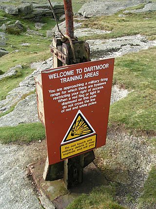
The Dartmoor Training Area (DTA) is a military training area on Dartmoor in Devon in southwest England. The area consists of approximately 13,000 hectares in the Dartmoor National Park.

Meldon Viaduct is a disused railway viaduct crossing the West Okement River at Meldon, 2.5 miles (4.0 km) south-west of Okehampton, on the edge of Dartmoor in Devon, South West England. This truss bridge was constructed from wrought iron, instead of stone or brick arches. It opened in 1874 for a single track; in 1879 its width was doubled for a second track. Although regular services were withdrawn in 1968, the bridge was used for shunting by a local quarry. In the 1990s the remaining single track was removed.
Okehampton Interchange is a proposed railway station in Okehampton on the Dartmoor Line. The station would be part of the Devon Metro and has been described as a priority station. The station is to be sited off Exeter Road, by the Business Park and close to the junction with the A30, in the Stockley Hamlet area of Okehampton. It will also serve 900 new homes to be built nearby.

Monkokehampton is a village and civil parish in West Devon, England. The village lies on the River Okement, about 3 miles (4.8 km) east-north-east of Hatherleigh. The parish is bounded by Hatherleigh, Exbourne, Broadwoodkelly and Iddesleigh, and had a population of 139 at the 2011 Census.

Southcott is a hamlet in the civil parish of Okehampton Hamlets, in West Devon, England. The hamlet name is Anglo Saxon in origin and means 'southern cottage'.

Bridestowe and Sourton Common, also known as Common to Bridestowe and Sourton and Lands common to the Parishes of Bridestowe and Sourton, is a civil parish in the district of West Devon, Devon, England. It is surrounded by the parishes of Okehampton Hamlets, Dartmoor Forest, Lydford, Bridestowe and Sourton.