River Otter, Devon

Last updated

River Otter
River Otter Devon.jpg
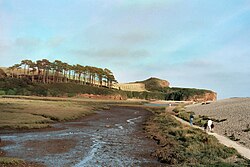
The tidal estuary of the Otter. The river flows left to right, in front of the distinctive hill. The marsh (foreground) is separated from the sea by a steep pebble bar (right).
River Otter map.png
Map of the River Otter and its catchment.
Location
Country England
Counties Somerset, Devon
Physical characteristics
Source 
  location Blackdown Hills, Somerset, England
  elevation275 m (902 ft) [1]
Mouth  
  location
Budleigh Salterton, Devon, England
  elevation
0 m (0 ft)
Length44 km (27 mi) [2]
Discharge 
  locationDotton
  average3.12 m3/s (110 cu ft/s)
  minimum0.46 m3/s (16 cu ft/s)(24 August 1976)
  maximum346.7 m3/s (12,240 cu ft/s)(11 July 1968)
Discharge 
  locationFenny Bridges
  average2.13 m3/s (75 cu ft/s)
Basin features
Tributaries 
  right River Tale [1]

The River Otter is a river that rises in the Blackdown Hills just inside the county of Somerset, England near Otterford, then flows south through East Devon. [3] It enters the English Channel at the western end of Lyme Bay, part of the Jurassic Coast, a UNESCO World Heritage Site. The Permian and Triassic sandstone aquifer in the Otter Valley is one of Devon's largest groundwater sources, supplying drinking water to 200,000 people.

Contents

Topography

Known as the Tumbling Weir, at Ottery St Mary, water flows inwards over concentric circles, returning to the river via a tunnel. Tumbling weir Devon 2.jpg
Known as the Tumbling Weir, at Ottery St Mary, water flows inwards over concentric circles, returning to the river via a tunnel.
Close up of the Tumbling Weir. Tumbling weir Devon3.jpg
Close up of the Tumbling Weir.
Bridge over River Otter, at Otterton. Bridge over River Otter, at Otterton, Devon, UK.jpg
Bridge over River Otter, at Otterton.
Fish pass on River Otter, alongside weir (top right in photo) near Otterton. Fish pass.jpg
Fish pass on River Otter, alongside weir (top right in photo) near Otterton.
Fish logo on tablet recording construction of the fish pass. Fish River Otter Devon.jpg
Fish logo on tablet recording construction of the fish pass.

The river's source is north of Otterford, where a stream feeds the Otterhead Lakes: ST225152 and then through Churchstanton before entering Devon.

The river flows through a predominantly rural area, with small cattle, sheep and dairy farms. The largest town in the Otter Valley is Honiton. Tourism and leisure play important roles in the economy. [4] For much of its length, the river flows through two Areas of Outstanding Natural Beauty (AONBs) – the Blackdown Hills National Landscape (to the north of Honiton) and East Devon National Landscape (to the south of Ottery St Mary).

The river passes through or by Upottery, Rawridge, Monkton, Honiton, Alfington, Ottery St Mary, Tipton St John, Newton Poppleford and Otterton. It then reaches the Otter Estuary to the east of Budleigh Salterton. [2]

The Otter Estuary Nature Reserve is a 57-acre (230,000 m2) Site of Special Scientific Interest (SSSI) consisting of tidal mudflats and saltmarsh. There is no public access to the estuary itself but footpaths lead to two viewing platforms on the west and two hides one on the west and one on the east. The wintering population of wildfowl and waders includes common redshank, greenshank, dunlin, common sandpiper, ringed plover, grey plover, Eurasian curlew, common snipe, water rail, Eurasian wigeon, Eurasian teal, common shelduck, brent goose, red-breasted merganser and little grebe. Eurasian reed warbler, reed bunting and sedge warbler breed on the reserve.

The Environment Agency measures the water level of the Otter and its tributaries at six or more "river level stations". [5]

The point at which the river reaches the coast ( SY077820 ) is part of the Jurassic Coast, a World Heritage Site. [1]

A small tributary is the River Tale, with the confluence NW of Ottery St Mary. This small town (associated with Samuel Taylor Coleridge, Sir Walter Raleigh, and an annual tar barrel rolling event) is the site of an unusual circular weir, known as the Tumbling Weir. Another small tributary is Budleigh Brook, which joins the Otter at East Budleigh.

At one time there were as many as fifty watermills powered by the River Otter. One of the remaining working mills, thought to date from the 17th century, is Tracey Mill near Honiton. In the 1970s, fish ponds were dug around the mill, fed by the leat; over a million gallons of fresh water flow through these ponds every day, helping the commercial production of trout "without the need for antibiotics or added oxygen".

One mill, at Dotton, is known to have operated from around 1100 to 1960, after which the building was demolished. The site was excavated by Channel 4's archaeological television programme Time Team , the episode "The Domesday Mill" being broadcast in 2007. This mill is mentioned in the Domesday Book. A weir diverted water to the mill's leat, supplying the vertical breast-shot wheel. Dotton (now little more than a farm) is 4.5 miles (7.2 km) from the mouth of the Otter, and about 1 mile (1.6 km) north of the village of Colaton Raleigh.

At the village of Otterton (once a seaport on a larger Otter Estuary), Otterton Mill is a working watermill over 1,000 years old; it was one of the three largest mills in Devon as recorded in the Domesday Book of 1086. It is powered by water diverted through a leat. Immediately north of the leat, a fish pass has been constructed beside a river-wide weir, restoring migratory fish runs to the river after a break of over 100 years.

Coleridge

The poet Samuel Taylor Coleridge (1772–1834), who was born in Ottery St Mary, wrote a sonnet entitled "Sonnet to the River Otter".

At Ottery St Mary the river is spanned by a 95-metre (312 ft) foot and cycle bridge named Coleridge Bridge; built at a cost approaching £1 million, this was officially opened on 29 August 2011. A small area of land at one end of the bridge was sold to the local authority by William Coleridge, 5th Baron Coleridge, a descendant of the poet.[ citation needed ]

Beaver population

The Otter is the only river in England known to contain a wild breeding population of Eurasian beavers, a species that died out in Britain in around 1550. The origin of the population is not known; it was first noticed in 2013, apparently successfully bearing three kits the next year. [6] [7]

Following concern from local landowners and anglers, as well as farmers worrying that the beavers could carry disease, the government announced that it would capture the beavers and place them in a zoo or wildlife park. A sport fishing industry lobbyist group, the Angling Trust, said "it would be irresponsible even to consider re-introducing this species into the wild without first restoring our rivers to good health." [8]

This decision to immediately remove the beavers was protested by local residents and campaign groups, with environmental journalist George Monbiot describing the government and Angling Trust as "control freaks": "I'm an angler, and the Angling Trust does not represent me on this issue...most anglers, in my experience, have a powerful connection with nature. The chance of seeing remarkable wild animals while waiting quietly on the riverbank is a major part of why we do it." [9] [10] The introduction of beavers to rivers has been encouraged by environmentalists, who have argued that beaver dams provide a habitat for birds and fish, reduce the strength of flooding by trapping water high up in a catchment area, away from homes further downstream, and could be a future tourist attraction.

In January 2015, Natural England said that the beavers would be allowed to remain on condition that they were disease-free and of the Eurasian species (not North American beavers, which would be invasive). These conditions were met, and the beavers were returned to the river as part of a five-year trial. [11] In August 2020, the government announced that the beavers, which by then numbered 15 family groups, could remain on the river indefinitely. It was the first legally sanctioned reintroduction of an extinct native animal anywhere in England. [12]

Related Research Articles

<span class="mw-page-title-main">River Exe</span> River in Devon and Somerset, England

The River Exe is a river in England that rises at Exe Head, near the village of Simonsbath, on Exmoor in Somerset, 5.2 miles (8.4 km) from the Bristol Channel coast, but flows more or less directly due south, so that most of its length lies in Devon. It flows for 60 miles (96 km) and reaches the sea at a substantial ria, the Exe Estuary, on the south coast of Devon. Historically, its lowest bridging point was the Old Exe Bridge in Exeter, the largest settlement on the river, but there is now a viaduct for the M5 motorway about 2 miles (3.2 km) south of the city centre.

<span class="mw-page-title-main">Budleigh Salterton</span> Town in Devon, England

Budleigh Salterton is a seaside town on the coast in East Devon, England, 15 miles (24 km) south-east of Exeter. It lies within the East Devon Area of Outstanding Natural Beauty, and forms much of the electoral ward of Budleigh, whose ward population at the 2021 census was 7,671.

<span class="mw-page-title-main">Otterton Mill</span> Water mill in Devon, England

Otterton Water Mill is at the village of Otterton, near Budleigh Salterton in Devon, England.

<span class="mw-page-title-main">East Devon</span> Non-metropolitan district in England

East Devon is a local government district in Devon, England. Its council is based in the town of Honiton, although Exmouth is the largest town. The district also contains the towns of Axminster, Budleigh Salterton, Cranbrook, Ottery St Mary, Seaton and Sidmouth, along with numerous villages and surrounding rural areas.

<span class="mw-page-title-main">Devon Wildlife Trust</span> Wildlife conservation charity

The Devon Wildlife Trust is a member of The Wildlife Trusts partnership covering the county of Devon, England. It is a registered charity, established in 1961 as the Devon Naturalists Trust, and its aim is to safeguard the future of the county's urban, rural and marine wildlife and its environment.

<span class="mw-page-title-main">Tumbling Weir</span> Circular weir in Devon, England

The Tumbling Weir is a circular weir in the town of Ottery St. Mary, Devon, England that allows water from a leat or man-made stream to reach the River Otter.

<span class="mw-page-title-main">Blackdown Hills</span> Hill range and natural landscape region in Dorset and Somerset

The Blackdown Hills, or Blackdowns, are a range of hills along the Somerset-Devon border in south-western England. The plateau is dominated by hard chert bands of Upper Greensand with some remnants of chalk, and is cut through by river valleys.

<span class="mw-page-title-main">Tiverton and Honiton (UK Parliament constituency)</span> Parliamentary constituency in the United Kingdom, 1997-2024

Tiverton and Honiton was a constituency in Devon, England. From its creation in 1997 until a 2022 by-election, the seat was represented by members of the Conservative Party. It was then held by Richard Foord of the Liberal Democrats until abolition.

<span class="mw-page-title-main">Honiton (UK Parliament constituency)</span>

Honiton was a parliamentary constituency centred on the town of Honiton in east Devon, formerly represented in the House of Commons of the Parliament of the United Kingdom. It sent members intermittently from 1300, consistently from 1640. It elected two Members of Parliament (MPs) until it was abolished in 1868. It was recreated in 1885 as a single-member constituency.

<span class="mw-page-title-main">Otterton</span> Village in Devon, England

Otterton is a village and civil parish in East Devon, England. The parish lies on the English Channel and is surrounded clockwise from the south by the parishes of East Budleigh, Bicton, Colaton Raleigh, Newton Poppleford and Harpford and Sidmouth. In 2001 its population was 700, compared to 622 a hundred years earlier. At the 2011 census the population had reduced to 656. Otterton is part of Raleigh electoral ward whose total population at the above census was 2,120.

<span class="mw-page-title-main">Colaton Raleigh</span> Village in Devon, England

Colaton Raleigh is a village and civil parish in East Devon, England. The parish is surrounded clockwise from the north by the parishes of Aylesbeare, Newton Poppleford and Harpford, Otterton, Bicton, Woodbury and a small part of Farringdon.

Tipton St John is a village in the civil parish of Ottery St Mary in the English county of Devon. It has a population of around 350. The village is built on rising ground overlooking the River Otter.

The hundred of East Budleigh was the name of one of thirty two ancient administrative units of Devon, England.

<span class="mw-page-title-main">Richard Duke (English lawyer)</span> British lawyer and politician

Richard Duke was a lawyer and served as Clerk of the Court of Augmentations which position assisted him in acquiring large grants of former monastic lands in the West Country following the Dissolution of the Monasteries. He served as MP for Weymouth in 1545 and for Dartmouth in 1547 and as Sheriff of Devon in 1563–64.

<span class="mw-page-title-main">Denys Rolle (died 1797)</span> British politician

Denys Rolle was a British politician and landowner who was an independent member of parliament for Barnstaple between 1761 and 1774. He inherited a large number of estates and by the time of his death he was the largest landowner in Devon. He was a philanthropist and generous benefactor to charities and religious societies.

<span class="mw-page-title-main">Manor of Otterton</span>

The Manor of Otterton was a medieval manor in East Devon, England.

<span class="mw-page-title-main">River Tale</span> River in Devon, England

The River Tale is a small river that drains the southern slopes of the Blackdown Hills, in Devon, England. It is a tributary of the River Otter and 8.8 miles (14.2 km) in length. Its name is derived from getæl meaning "quick, active or swift"; however, the river is noted as being "sluggish". One theory is that its name was transferred from Tala Water, a tributary of the nearby River Tamar. The river is the site of ongoing efforts to reintroduce the water vole, which is thought to be extinct in Devon.

<span class="mw-page-title-main">Eurasian beaver reintroduction</span> Effort in Europe to restore beaver range

The Eurasian beaver has been the successful subject of a century of official and unapproved species reintroduction programs in Europe and Asia. Beavers had been driven to the point of near extinction in Eurasia by humans trapping and hunting them for their meat, fur and castoreum. The reintroductions and conservation led in 2008, to the IUCN assessing the Eurasian beaver as being of "least concern" on its red list.

References

  1. 1 2 3 Knott, Eleanor. "River Otter catchment overview" (PDF). Devon Biodiversity Records Centre/University of Exeter . Retrieved 1 June 2020.
  2. 1 2 "Enhancing The River Otter". Agricultural & Environmental Data Archive . Environment Agency . Retrieved 2 June 2020.
  3. Sinclair, Archibald (1843). A system of modern geography. Shields & Son. p. 267.
  4. "Tourists flock to see River Otter beavers". East Devon. Retrieved 26 April 2017.
  5. River level stations
  6. "Beaver spotted in Devon's River Otter by dog walker". BBC News. Retrieved 2 October 2014.
  7. Aldred, Jessica (17 July 2014). "Wild beaver kits born in Devon". Guardian. Retrieved 2 October 2014.
  8. Lloyd, Mark. "Angling Trust welcomes action to remove beavers from Devon River". Angling Trust. Retrieved 1 October 2014.
  9. Monbiot, George (4 July 2014). "Stop the control freaks who want to capture England's wild beavers". Guardian. Retrieved 1 October 2014.
  10. "Overwhelming support for River Otter beavers to stay wild heard at consultation". Exeter Express & Echo. Retrieved 2 October 2014.
  11. "The River Otter Beaver Trial | Devon Wildlife Trust".
  12. "England's first wild beavers for 400 years allowed to live on River Otter". Guardian. 6 August 2020. Retrieved 6 August 2020.

50°40′13″N3°17′41″W / 50.670224°N 3.294590°W / 50.670224; -3.294590