River Ottery

Last updated • 3 min readFrom Wikipedia, The Free Encyclopedia

Sketch map of the River Ottery and tributaries (click to enlarge) CornwallMap2.png
Sketch map of the River Ottery and tributaries (click to enlarge)
Ford and bridge at Trengune Trengune - geograph.org.uk - 210786.jpg
Ford and bridge at Trengune
The River Ottery at Canworthy Water River Ottery - geograph.org.uk - 212774.jpg
The River Ottery at Canworthy Water

The River Ottery (Cornish : Otri) [1] is a small river in northeast Cornwall, England, United Kingdom. The river is about twenty miles (32 km) long from its source southeast of Otterham to its confluence with the River Tamar at Nether Bridge, two miles (3.2 km) northeast of Launceston. [2] [3]

Contents

The headwaters of the River Ottery are within the civil parish of Otterham but formerly came under the parish of Forrabury and Minster. In 1311, the rector of that parish wrote: "..the river Ottery takes its rise in this parish and flows to Canworthy Water and so by Yeolmbridge to the river Tamar." [4]

Hydrology and course

With its tributaries, the River Ottery forms a major sub-catchment of the Tamar system, draining 48 square miles (120 km2) of north Cornwall. The Ottery's catchment area is within the Carboniferous geological formation known as the Culm Measures which stretches from Dartmoor to north Devon and across northeast Cornwall as far west as Bodmin Moor. [2] [5]

The infant river initially flows north until it reaches the hamlet of Trengune. From here it adopts an east-southeasterly course which it follows to its confluence with the River Tamar.

The largest tributaries to the River Ottery are Caudworthy Water and Bolsbridge Water which join the Ottery from the north and Canworthy Water which joins from the south.

The River Ottery system was severely affected by flooding in north Cornwall on 16 August 2004 when up to eight inches of rain fell during a single afternoon. [6] The Ottery headwaters at Marshgate and Otterham were the most severely affected.

The river flows through an isolated area of mixed farming and the only riverside settlements of any size are Canworthy Water and Yeolmbridge.

Wildlife and conservation

The Cornwall Rivers Project notes five Sites of Special Scientific Interest (SSSI) in the Ottery catchment including the Ottery Valley SSSI which has 33 hectares of increasingly threatened culm habitat and Kernick and Ottery Meadows SSSI, also noted for its biological interest. [7] [8]

The project's page also notes: "The Ottery supports a broad range of wildlife including populations of trout and migratory fish, otters, kingfishers, sand martins, dippers, curlews, snipe and the marsh fritillary butterfly." [2]

History

The majority of the boundary between Cornwall and Devon follows the River Tamar, and Celtic place-names, such as those including the element tre-, stop for the most part exactly at the Tamar, reflecting this ancient boundary. However, the part of Cornwall north of the River Ottery has few place-names including tre- and far more of Old English origin (such as those ending in -dun and -cot) than the rest of the county. This indicates that the river formed an early boundary between the rump of Dumnonia and the westward expansion of the Anglo-Saxon kingdom of Wessex. [9] [10]

Location

Related Research Articles

<span class="mw-page-title-main">River Tamar</span> River in southwest England

The Tamar is a river in south west England that forms most of the border between Devon and Cornwall. A large part of the valley of the Tamar is protected as the Tamar Valley National Landscape, and some is included in the Cornwall and West Devon Mining Landscape due to its historic mining activities.

<span class="mw-page-title-main">River Lynher</span> River in east Cornwall, England

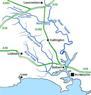
The River Lynher flows through east Cornwall, England, and enters the River Tamar at the Hamoaze, which in turn flows into Plymouth Sound.

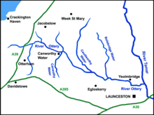
Jacobstow is a civil parish and village in north Cornwall, England, United Kingdom. The village is located east of the A39 road approximately seven miles (11 km) south of Bude.

<span class="mw-page-title-main">River Garnock</span> River in Scotland

The River Garnock, the smallest of Ayrshire's six principal rivers, has its source on the southerly side of the Hill of Stake in the heart of the Clyde Muirshiel Regional Park. About a mile and a half south of this starting point the untested stream tumbles over the Spout of Garnock, the highest waterfall in Ayrshire, once thought to be the river's origin. The river then continues, for a total length of 20 miles (32 km) or so, through the towns of Kilbirnie, Glengarnock, Dalry and Kilwinning to its confluence with the River Irvine at Irvine Harbour.

<span class="mw-page-title-main">River Hayle</span> River in west Cornwall, England

The River Hayle is a small river in West Cornwall, England, United Kingdom which issues into St Ives Bay at Hayle on Cornwall's Atlantic coast.

<span class="mw-page-title-main">River Inny, Cornwall</span> River in east Cornwall, England

The River Inny is a small river in East Cornwall, England, United Kingdom. A tributary of the River Tamar, the Inny is about twenty miles (32 km) long from its source near Davidstow on the eastern flank of Bodmin Moor to its confluence with the Tamar at Inny Foot near Dunterton.

<span class="mw-page-title-main">St Gennys</span>

St Gennys is a coastal civil parish and small settlement in north Cornwall, England, United Kingdom.

<span class="mw-page-title-main">North Tamerton</span> Village and civil parish in east Cornwall, England

North Tamerton is a village and civil parish in east Cornwall, England, UK. The village is situated approximately eight miles (13 km) southeast of Bude and eight miles (13 km) north of Launceston.

<span class="mw-page-title-main">Otterham</span> Human settlement in England

Otterham is a village and a civil parish in north Cornwall, England, United Kingdom. The village is situated approximately ten miles (16 km) south of Bude and six miles (9.7 km) north of Camelford.

<span class="mw-page-title-main">St Stephens by Launceston Rural</span>

St Stephens by Launceston Rural is a civil parish in the east of Cornwall, England, United Kingdom. It is in the Registration district of Launceston. The population of the parish in the 2001 census was 312, increasing to 360 and including Dutson at the 2011 census. The former parish of St Stephens by Launceston was abolished in 1894: St Stephens by Launceston Urban became part of the town of Launceston, while St Stephens by Launceston Rural became part of Launceston Rural District.

<span class="mw-page-title-main">Canworthy Water</span> Settlement in Cornwall, England

Canworthy Water is a settlement in northeast Cornwall, England, United Kingdom. It is situated beside the River Ottery at OS grid ref SX224918 approximately seven miles (11 km) northeast of Camelford.

<span class="mw-page-title-main">De Lank River</span> River in north Cornwall, England

The De Lank River is a small river in north Cornwall, England. It is a tributary of the River Camel and is approximately nine miles (14.5 km) long from its source on Bodmin Moor to its confluence with the Camel two miles (3 km) south of St Breward.

<span class="mw-page-title-main">Luckett, Cornwall</span> Hamlet in Cornwall, England

Luckett is a hamlet in east Cornwall, England. It is situated in a former mining area beside the River Tamar approximately three miles (5 km) north of Callington. According to the Post Office the population at the 2011 census was included in the civil parish of Stokeclimsland

<span class="mw-page-title-main">Restronguet Creek</span> Tidal ria in south Cornwall, England

Restronguet Creek is a tidal ria in south Cornwall, United Kingdom. It is a tributary of Carrick Roads, the estuary of the River Fal, and is situated approximately four miles (6.5 km) south of Truro and three miles (5 km) north of Falmouth.

<span class="mw-page-title-main">St Austell River</span> River in south Cornwall, England

The St Austell River properly known as the River Vinnick, but historically called The White River, is a 12 kilometres (7.5 mi) long river located in south Cornwall, England, United Kingdom. 50.337°N 4.793°W. The river has also been known as the "red river" due to tin streaming and mining activity upstream.

Caroe is a small hamlet in the parish of Otterham, Cornwall, England. Caroe is situated approximately ten miles (16 km) south of Bude and six miles (9.7 km) north of Camelford. Caroe is at around 660 feet (201 m) above sea level and lies on the western side of the River Ottery.

Meddon Moor is a Site of Special Scientific Interest (SSSI) in Cornwall, England. The moor is located in the very north-eastern corner of Cornwall, on the border with Devon, within the civil parish of Morwenstow. The Devon village of Meddon lies 500 metres (1,600 ft) to the north-east of the moor.

Lymsworthy Meadows is a Site of Special Scientific Interest (SSSI) in north Cornwall, England, UK, noted for its biological characteristics.

<span class="mw-page-title-main">River Lerryn</span> River in east Cornwall, England

The River Lerryn is a river in east Cornwall, England, UK, a tributary of the River Fowey. The Lerryn is the largest of the tributaries which enter the estuary of the Fowey. The river is tidal up to the village of Lerryn. The landscape of the Lerryn catchment is rural and includes heathland, moorland and rough pasture in the upper reaches and broadleaf, coniferous and mixed plantation woodland in the lower. This catchment includes four SSSIs, including Redlake Meadows & Hoggs Moor. The Lerryn rises at Fairy Cross on the southern slopes of Bodmin Moor and flows south-southwest until it enters the Fowey estuary.

References

  1. Place-names in the Standard Written Form (SWF)  : List of place-names agreed by the MAGA Signage Panel Archived 2013-05-15 at the Wayback Machine . Cornish Language Partnership.
  2. 1 2 3 "River Catchments - Ottery". Cornwall rivers project. Retrieved 21 December 2019.
  3. Landranger map sheet 190. Bude & Clovelly. Southampton: Ordnance Survey. ISBN   978 0 319 23145 6.
  4. Boscastle village website; Otterham Church; retrieved April 2010 Archived 14 May 2010 at the Wayback Machine
  5. English Nature website. Retrieved April 2010
  6. Met Office report. Retrieved April 2010
  7. "Ottery Valley" (PDF). Natural England. 1994. Archived from the original (PDF) on 24 October 2012. Retrieved 2 November 2011.
  8. "Kernick and Ottery Meadows" (PDF). Natural England. 1992. Archived from the original (PDF) on 24 October 2012. Retrieved 2 November 2011.
  9. Payton, Philip (2004). Cornwall: A History (2nd ed.). Fowey: Cornwall Editions Ltd. p. 68. ISBN   1-904880-00-2.
  10. Padel, O. J. (1999). "Place-names". In Kain, Roger; Ravenhill, William (eds.). Historical Atlas of South-West England. Exeter: University of Exeter Press. pp. 88–9. ISBN   0-85989-434-7.