Porthgwarra to Pordenack Point

Last updated
Porthgwarra to Pordenack Point
Site of Special Scientific Interest
Headland between Hella Point and Gwennap Head - geograph.org.uk - 661916.jpg
Headland between Hella Point and Gwennap Head within the SSSI
Southwest Cornwall UK location map.svg
Red pog.svg
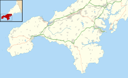
Location within Southwest Cornwall
Area of Search Cornwall
Grid reference SW371217 to SW345241
Coordinates 50°02′40″N5°41′12″W / 50.0444°N 5.6866°W / 50.0444; -5.6866 Coordinates: 50°02′40″N5°41′12″W / 50.0444°N 5.6866°W / 50.0444; -5.6866
InterestBiological
Area158 hectares (1.58 km2; 0.610 sq mi)
Notification 1977 (1977)
Natural England website

Porthgwarra to Pordenack Point is a coastal Site of Special Scientific Interest (SSSI) in west Cornwall, England, noted for its biological characteristics. [1] [ dead link ] The South West Coast Path runs through the SSSI.

Contents

Geography

The 158-hectare (390-acre) site, notified in 1977, is located on the western coast of Cornwall, 2.5 miles (4 km) south of Land's End. It starts in the south at the settlement of Porthgwarra and continues north along the coast of the last sections of the English Channel to Pordenack Point in the north. [2] [3] Other designations are part of the Cornwall Area of Outstanding Natural Beauty, a Geological Conservation Review site, part of the Penwith Heritage coast, Nature Conservation Reviewsite and there are Scheduled Ancient Monuments within the area.

Wildlife and ecology

Porthgwarra to Pordenack Point Site of Special Scientific Interest (SSSI) is designated for its vegetation of waved maritime heath, and for being of considerable ornithological interest; especially for passage migrants. [1] The southern section, Tol Pedn or Gwennap Head, in particular is favoured by birdwatchers and many travel the length and breadth of Britain to track rare seabirds. [4] The headland is renowned for its relative abundance of passing marine bird species with many common species such as northern gannet (Morus bassanus), Manx shearwater (Puffinus puffinus), common guillemot, (Uria aalge), razorbill (Alca torda), northern fulmar (Fulmarus glacialis), shag (Phalacrocorax aristotelis) and cormorant (Phalacrocorax carbo). Forty-five breeding species have been recorded including the red-billed choughs (Pyrrhocorax pyrrhocorax) which have recently been breeding successfully on Gwennap Head, but lost their young to a predator in early May 2015. [1] [5] Other species include Eurasian teal (Anas crecca), which is a rare as a breeding bird in Cornwall and European stonechat (Saxicola rubicola) and common whitethroat (Sylvia communis). [1]

Resident butterflies include the silver studded blue (Plebejus argus), large white (Pieris brassicae), small copper (Lycaena phlaeas), common blue (Polyommatus icarus), small tortoiseshell (Aglais urticae), peacock (Aglais io), comma (Polygonia c-album), small pearl-bordered fritillary (Boloria selene), speckled wood (Pararge aegeria), grayling (Hipparchia semele) and wall (Lasiommata megera). Some insects also migrate and butterflies often seen include clouded yellow (Colias croceus), red admiral (Vanessa atalanta) and painted lady (Vanessa cardui). Migrant moths include rush veneer (Nomophila noctuella), rusty-dot pearl (Udea ferrugalis), hummingbird hawk-moth (Macroglossum stellatarum) and silver Y (Autographa gamma). [6] [7]

In 2010 perennial centaury ( Centaurium scilloides ), a national rarity, was refound by Helen and Laurie Oakes. Despite many searches by botanists the species had not been seen in Cornwall (and England) since 1962 (or possibly 1967), and survived on only one Welsh site; coastal footpaths of Pembrokeshire National Park, Wales. [8] [9]

Related Research Articles

Gibraltar Point

Gibraltar Point national nature reserve is an area of about 4.3 km2 (1.7 sq mi) on the coast of Lincolnshire, England.

Cotswold Water Park

The Cotswold Water Park is the United Kingdom's largest marl lake system, straddling the Wiltshire–Gloucestershire border, northwest of Cricklade and south of Cirencester. The lakes were created in the second half of the 20th century by extraction of glacial Jurassic limestone gravel, which had eroded from the Cotswold Hills, and these filled naturally after working began to cease in the early 1970s.

Aire Point to Carrick Du SSSI

Aire Point to Carrick Du SSSI is a Site of Special Scientific Interest on the Penwith Peninsula, Cornwall, England. It is 5.98 square kilometres in extent, stretching from grid reference SW360279 to grid reference SW513410. The site is designated both for its biological and its geological interest.

Hayle Estuary and Carrack Gladden SSSI

The Hayle Estuary and Carrack Gladden SSSI is a Site of Special Scientific Interest, noted for its biological interest, in west Cornwall, England, UK. It consists of three distinct parts, each of which is covered in a separate article: the Hayle Estuary, the sand-dune system of Porth Kidney Sands and the coastal headland at Carrack Gladden.

St Levan Human settlement in England

St Levan is a civil parish in Cornwall, England, United Kingdom. The parish is rural with a number of hamlets of varying size with Porthcurno probably being the best known. Hewn out of the cliff at Minack Point and overlooking the sea to the Logan Rock is the open-air Minack Theatre, the inspiration of Rowena Cade in the early 1930s.

Annet, Isles of Scilly

Annet is the second largest of the fifty or so uninhabited Isles of Scilly, 1 kilometre (0.62 mi) west of St Agnes with a length of 1 kilometre (0.62 mi) and approximately 22 hectares in area. The low-lying island is almost divided in two by a narrow neck of land at West Porth which can, at times, be covered by waves. At the northern end of the island are the two granite carns of Annet Head and Carn Irish and three smaller carns known as the Haycocks. The rocky outcrops on the southern side of the island, such as South Carn, are smaller. Annet is a bird sanctuary and the main seabird breeding site in Scilly.

Goss Moor

Goss Moor is a national nature reserve in Cornwall, England, 12 kilometres (7.5 mi) south-west of Bodmin in the parishes of St Dennis, St Columb Major, Roche and St Enoder. It is the largest continuous mire complex in south-west Britain and consists of mainly peatland and lowland heath. Together with the neighbouring moor to the east, it forms the Goss And Tregoss Moors Site of Special Scientific Interest (SSSI), as well as the Breney Common and Goss and Tregoss Moors Special Area of Conservation (SAC).

Gwennap Head Headland in Cornwall, England

Gwennap Head is a headland on the south coast of the Penwith peninsula, Cornwall, United Kingdom. It is within the parish of St Levan and approximately 4 miles (6.4 km) south of Land's End, and less than 1 mile (1.6 km) north-west of Porthgwarra, the nearest village. The area of Gwennap Head is designated as part of the Penwith Heritage Coast and also designated as part of the Cornwall Area of Outstanding Natural Beauty. The South West Coast Path closely follows the coastline around the headland.

Birds of Cornwall

The birds of Cornwall are in general a selection of those found in the whole of the British Isles, though Cornwall's position at the extreme south-west of Great Britain results in many occasional migrants. The nightingale is one common English bird which is virtually absent from Cornwall.

Treen Cliff Site of Special Scientific Interest on the Penwith Peninsula in Cornwall, England

Treen Cliff is a Site of Special Scientific Interest (SSSI) located on the Penwith Peninsula in Cornwall, England, UK, 6 miles (9.7 km) south-west of Penzance. First notified in 1951, with a revision in 1973, and a further notification on 1 July 1986, it is 49.3 hectares in area, stretching from grid reference SW387220 to SW402225. Designated for both for its biological and geological interest, part of the site, Treryn Dinas, is a Scheduled Ancient Monument consisting of a "cliff castle" with four ramparts and ditches and the Logan Rock. It is within the Cornwall Area of Outstanding Natural Beauty (AONB), the Penwith Heritage Coast and is part owned and managed by the National Trust.

Rinsey Hamlet in Cornwall, England

Rinsey is a hamlet in Cornwall, England, United Kingdom. It is located off the main A394 road between Helston and Penzance in the civil parish of Breage. The nearby hamlet of Rinsey Croft is located 1 km to the north-east. The nearby cliffs and beach are owned and managed by the National Trust and part of Rinsey East Cliff is designated as the Porthcew Site of Special Scientific Interest (SSSI) for its geological interest. The South West Coast Path passes through the property. Rinsey lies within the Cornwall Area of Outstanding Natural Beauty (AONB).

Boscastle to Widemouth

Boscastle to Widemouth is a coastal Site of Special Scientific Interest (SSSI) in Cornwall, England, noted for its biological and geological characteristics. The Dizzard dwarf oak woodland is unique and of international importance for its lichen communities, with 131 species recorded.

Caerthillian to Kennack

Caerthillian to Kennack is a coastal Site of Special Scientific Interest (SSSI) on the Lizard Peninsula in Cornwall, UK, noted for both its biological and geological characteristics. It is of great botanical importance, with several Red Data Book of rare and endangered plant species being found on the site, as well as a breeding site for Cornish choughs.

Steeple Point to Marsland Mouth

Steeple Point to Marsland Mouth is a coastal Site of Special Scientific Interest (SSSI) in Cornwall, England, UK, noted for its biological characteristics.

Kelsey Head

Kelsey Head is a coastal Site of Special Scientific Interest (SSSI) and headland in north Cornwall, England, UK, noted for its biological interest. The site contains an Iron Age hill fort.

Godrevy Head to St Agnes

Godrevy Head to St Agnes is a coastal Site of Special Scientific Interest (SSSI) in north Cornwall, England, UK, noted for both its biological and geological characteristics. A number of rare and scarce plant species can be found on the site, along with many breeding seabirds.

Eastern Isles

The Eastern Isles are a group of twelve small uninhabited islands within the Isles of Scilly Area of Outstanding Natural Beauty, part of the Scilly Heritage Coast and a Site of Special Scientific Interest (SSSI) first designated in 1971 for its flora and fauna. They have a long period of occupation from the Bronze Age with cairns and entrance graves through to Iron Age field systems and a Roman shrine on Nornour. Before the 19th century, the islands were known by their Cornish name, which had also become the name of the largest island in the group after the submergence of the connecting lands.

Glannau Rhoscolyn

Glannau Rhoscolyn is a Site of Special Scientific Interest in Anglesey, North Wales, and extends along the west coast of Holy Island, Anglesey for approximately 6.5 km. It has been designated as a Site of Special Scientific Interest since January 1961 in an attempt to protect its fragile biological and geological elements. The site has an area of 145.49 hectares and is managed by Natural Resources Wales.

Bamburgh Coast and Hills

Bamburgh Coast and Hills is the name given to a Site of Special Scientific Interest (SSSI) on the coast of north Northumberland, England. The site is one of the longest-standing SSSIs in England, having been listed since 1954, and displays the interaction of a fluid magma rock, now known as the Whin Sill, interacting with older sedimentary rock. Coastal erosion at the site enables sections of the geological strata to be seen. In turn, the soil associated with the Whin Sill gives rise to a distinct pattern of vegetation which on its own merits is at this site found notable.

References

  1. 1 2 3 4 "Porthgwarra to Pordenack Point" (PDF). Natural England. 1986. Retrieved 13 July 2013.
  2. "Porthgwarra to Pordenack Point map". Natural England . Retrieved 11 July 2020.
  3. Ordnance Survey: Landranger map sheet 203 Land's End ISBN   978-0-319-23148-7
  4. "Wildlife of Gwennap Head". National Coastwatch. Retrieved 13 July 2015.
  5. Williamson, Laurie (25 June 2015). "CoastWatch". The Cornishman. p. 32.
  6. Wynn, Russell B; Brereton, Tom M; Jones, Alice R; Lewis, Kate M, eds. (2010). SeaWatch SW Annual Report 2009 (PDF). Southampton: National Oceanography Centre. p. 118. Archived from the original (PDF) on 24 September 2015. Retrieved 18 December 2014.
  7. Drayson, Paul (2012). Carey, Andrew (ed.). "Over Fifty Years of Observing Butterflies in West Cornwall" (PDF). The Butterfly Observer. 52 (Summer): 17–22. Retrieved 18 December 2014.
  8. Ian Bennallack (2010). Bennallick, I A; Pearman, D A (eds.). "Centaurium scilloides, Juncus subnodulosus and Phegopteris connectilis re-discovered in Cornwall after many years". Botanical Cornwall. Truro: Environmental Records Centre for Cornwall & the Isles of Scilly (ERCCIS) (14): 36–42. ISSN   1364-4335.
  9. "UK: First centaury sighting in half a century". Plant Talk. Eden Project. Retrieved 13 July 2015.