
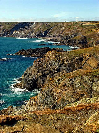
The Lizard is a peninsula in southern Cornwall, England, United Kingdom. The most southerly point of the British mainland is near Lizard Point at SW 701115; Lizard village, also known as The Lizard, is the most southerly on the British mainland, and is in the civil parish of Landewednack, the most southerly parish. The valleys of the River Helford and Loe Pool form the northern boundary, with the rest of the peninsula surrounded by sea. The area measures about 14 by 14 miles. The Lizard is one of England's natural regions and has been designated as a National Character Area 157 by Natural England. The peninsula is known for its geology and for its rare plants and lies within the Cornwall Area of Outstanding Natural Beauty (AONB).

St Keverne is a civil parish and village on The Lizard in Cornwall, England, United Kingdom.

The River Fal flows through Cornwall, rising at Pentevale on Goss Moor and reaching the English Channel at Falmouth. On or near the banks of the Fal are the castles of Pendennis and St Mawes as well as Trelissick Garden. The River Fal separates the Roseland peninsula from the rest of Cornwall. Like most of its kind on the south coast of Cornwall and Devon, the Fal estuary is a classic ria, or drowned river valley. The Fal estuary from Tregony to the Truro River was originally called Hafaraell.

Porthleven is a town, civil parish and fishing port near Helston, Cornwall, England, United Kingdom. The most southerly port in Great Britain, it was a harbour of refuge when this part of the Cornish coastline was infamous for wrecks in the days of sail. The South West Coast Path from Somerset to Dorset passes through the town. The population at the 2011 census was 3,059.

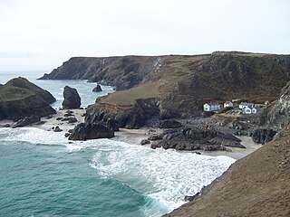
Coverack is a coastal village and fishing port in Cornwall, UK. It lies in the parish of St Keverne, on the east side of the Lizard peninsula about nine miles (14 km) south of Falmouth.

The Manacles are a set of treacherous rocks off The Lizard peninsula in Cornwall. The rocks are rich in marine wildlife and they are a popular spot for diving due to the many shipwrecks. Traditionally pronounced mean-a'klz (1808), the name derives from the Cornish meyn eglos, the top of St Keverne church spire being visible from the area.
Kynance Cove is a cove on the eastern side of Mount's Bay, Cornwall, England. It is situated on the Lizard peninsula approximately two miles (3 km) north of Lizard Point. The cove became popular in the early Victorian era, with many distinguished visitors including Queen Victoria and Prince Albert and the poets Alfred Tennyson and Algernon Swinburne. The BBC has described Kynance Cove as "one of the most beautiful stretches of coastline in the South West". The South West Coast Path, which follows the coast of south west England from Somerset to Dorset passes by on the cliffs overlooking the cove.

Mullion is a civil parish and village on the Lizard Peninsula in south Cornwall, England, United Kingdom. The nearest town is Helston approximately 5 miles (8 km) to the north.

Porthoustock is a hamlet near St Keverne in Cornwall, England, United Kingdom, on the east coast of Lizard Peninsula. Aggregates are quarried nearby and Porthoustock beach is dominated by a large concrete stone silo that was once used to store stone ready to load ships but is now disused. Coastal trading ships of up to 82 metres can dock alongside the pier along the southern edge of the beach to be loaded with stone. Fishing boats operate from the pebble beach, with lobster and crab potting, net fishing and hand lines as the principal fishing methods. The South West Coast Path passes through Porthoustock.
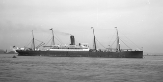
The SS Mohegan was a steamer which sank off the coast of the Lizard Peninsula, Cornwall, on her second voyage. She hit The Manacles on 14 October 1898 with the loss of 106 out of 197 on board.

Cornish cuisine encompasses the cooking styles, traditions and recipes associated with Cornwall and the Cornish people. It has been heavily influenced by the geography of the county as well as its social history.

The Meneage is a district in west Cornwall, United Kingdom. The nearest large towns are Falmouth and Helston.

Porthallow is a small fishing village on the east coast of The Lizard peninsula to the south of the Helford River, in Cornwall, England. It lies in St Keverne parish, north of St Keverne village. One road runs through the village, and there is public house, the Five Pilchards, named for the pilchard fishery. Porthallow is at the midpoint of the South West Coast Path and is within the Cornwall Area of Outstanding Natural Beauty (AONB).
Caerthillian to Kennack is a coastal Site of Special Scientific Interest (SSSI) on the Lizard Peninsula in Cornwall, UK, noted for both its biological and geological characteristics. It is of great botanical importance, with several Red Data Book of rare and endangered plant species being found on the site, as well as a breeding site for Cornish choughs.

Carricknath Point to Porthbean Beach is a coastal Site of Special Scientific Interest (SSSI) in Cornwall, England, UK, noted for its biological interest.

Gerrans Bay to Camels Cove is a coastal Site of Special Scientific Interest (SSSI) in south Cornwall, England, UK, noted for both its biological and geological interest.
Kennack to Coverack is a coastal Site of Special Scientific Interest (SSSI) on the Lizard Peninsula in Cornwall, England, UK, noted for both its biological and geological interest. It is of botanical importance, with 8 Red Data Book of rare and endangered plant species being found on the site as well as other nationally scarce varieties.

Meneage Coastal Section is a coastal Site of Special Scientific Interest (SSSI) in southern Cornwall, England, UK, noted for its geological characteristics.

Cornish promontory forts, commonly known in Cornwall as cliff castles, are coastal equivalents of the hill forts and Cornish "rounds" found on Cornish hilltops and slopes. Similar coastal forts are found on the north–west European seaboard, in Normandy, Brittany and around the coastlines of the British Isles, especially in Wales, Scotland and Ireland. Many are known in southwest England, particularly in Cornwall and its neighbouring county, Devon. Two have been identified immediately west of Cornwall, in the Isles of Scilly.

The Cornish Bronze Age is an era of the prehistory of Cornwall that spanned the period from c. 2400 BCE to c. 800 BCE. It was preceded by the Cornish Neolithic, and followed by the Cornish Iron Age. It is characterized by the introduction and widespread use of copper and copper-alloy (bronze) weapons and tools.


