
Mount Wellington Tin mine, two miles east of the village of St Day in Cornwall, in the United Kingdom, opened in 1976 and was the first new mine in the region in many years.

Geevor Tin Mine, formerly North Levant Mine is a tin mine in the far west of Cornwall, England, between the villages of Pendeen and Trewellard. It was operational between 1911 and 1990 during which time it produced about 50,000 tons of black tin. It is now a museum and heritage centre left as a living history of a working tin mine. The museum is an Anchor Point of ERIH, The European Route of Industrial Heritage. Since 2006, the mine has been part of the UNESCO World Heritage Site Cornwall and West Devon Mining Landscape.

St Day is a civil parish and village in Cornwall, England, United Kingdom. It is positioned between the village of Chacewater and the town of Redruth. The electoral ward St Day and Lanner had a population of 4,473 according to the 2011 census.

Poldice mine is a former metalliferous mine located in Poldice Valley in southwest Cornwall, England, United Kingdom. It is situated near the hamlet of Todpool, between the villages of Twelveheads and St Day, three miles (5 km) east of Redruth. Since the early 2000’s the area has been adopted by the local mountain biking community known as the Dice Rollers. The area is now nationally famous as the best location to ride MTB in the south west attracting attention from youtube superstars such as Ben Deakin and his friend Matt Edgie. This is a popular location for mountain bicycling

Mining in Cornwall and Devon, in the southwest of Britain, is thought to have begun in the early-middle Bronze Age with the exploitation of cassiterite. Tin, and later copper, were the most commonly extracted metals. Some tin mining continued long after the mining of other metals had become unprofitable, but ended in the late 20th century. In 2021, it was announced that a new mine was extracting battery-grade lithium carbonate, more than 20 years after the closure of the last South Crofty tin mine in Cornwall in 1998.

Gwennap is a village and civil parish in Cornwall, England, United Kingdom. It is about five miles (8 km) southeast of Redruth. Hamlets of Burncoose, Comford, Coombe, Crofthandy, Cusgarne, Fernsplatt, Frogpool, Hick's Mill, Tresamble and United Downs lie in the parish, as does Little Beside country house.

The Cornwall and West Devon Mining Landscape is a World Heritage Site which includes select mining landscapes in Cornwall and West Devon in the south west of England. The site was added to the World Heritage List during the 30th Session of the UNESCO World Heritage Committee in Vilnius, July 2006. Following plans in 2011 to restart mining at South Crofty, and to build a supermarket at Hayle Harbour, the World Heritage Committee drafted a decision in 2014 to put the site on the List of World Heritage in Danger, but this was rejected at the 38th Committee Session at Doha, Qatar, in favour of a follow-up Reactive Monitoring Mission.

Dolcoath mine was a copper and tin mine in Camborne, Cornwall, United Kingdom. Its name derives from the Cornish for 'Old Ground', and it was also affectionately known as The Queen of Cornish Mines. The site is north-west of Carn Brea. Dolcoath Road runs between the A3047 road and Chapel Hill. The site is south of this road.
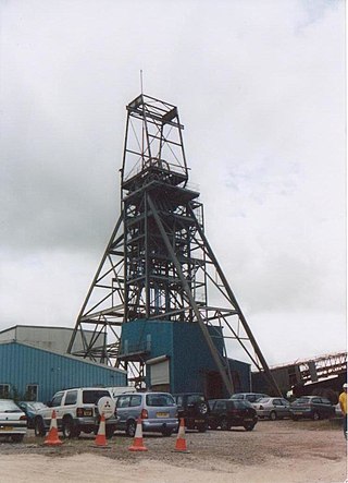
South Crofty is a metalliferous tin and copper mine located in the village of Pool, Cornwall, England. An ancient mine, it has seen production for over 400 years, and extends almost two and a half miles across and 3,000 feet (910 m) down and has mined over 40 lodes. Evidence of mining activity in South Crofty has been dated back to 1592, with full-scale mining beginning in the mid-17th century. The mine went into serious decline after 1985 and eventually closed in 1998. After several changes of ownership, South Crofty is owned by Cornish Metals Inc, which is working to re-open the mine, as of November 2022, having received a permit for dewatering the mine.
The Great County Adit, sometimes called the County Adit, or the Great Adit was a system of interconnected adits that helped drain water from the tin and copper mines in the Gwennap area of Cornwall, in the United Kingdom. Construction started in 1748 and it eventually reached a length of over 40 miles (64 km) of a tunnel, providing drainage to over 100 mines at an average depth of 80–100 metres (260–330 ft).

Wheal Peevor was a metalliferous mine located on North Downs about 1.5 miles north-east of Redruth, Cornwall, England. The first mining sett was granted here in around 1701 on land owned by the St Aubyn family. It was originally mined at shallow depths for copper, but when the price for that metal slumped after 1788, the mine was able to change to mining tin ore, which was found deeper down. In the late 18th century Wheal Peevor had the advantage of being drained by the Great County Adit which was around 100 metres deep here. The mine covered only 12 acres but had rich tin lodes. In addition to tin and copper, pyrite was also mined here between 1872 and 1887.

East Wheal Rose was a metalliferous mine around three-quarters of a mile (1.2 km) south east of the village of St Newlyn East and is around 4 miles (6.4 km) from Newquay on the north Cornwall coast, United Kingdom. The country rock at the mine was killas and its main produce was lead ore (galena), but as is usual when mining this mineral, commercial quantities of silver and zinc were also found and sold.
Wheal Vor was a metalliferous mine about 2 miles (3.2 km) north west of Helston and 1 mile (1.6 km) north of the village of Breage in the west of Cornwall, England, UK. It is considered to be part of the Mount's Bay mining district. Until the mid-19th century the mine was known for its willingness to try out new innovations. Although very rich in copper and tin ores, the mine never lived up to its expectations. During the later part of the 19th century it had several periods of closure, with an attempt to reopen it in the 1960s which was not successful mainly because of bureaucracy. Today the site is part of the Cornwall and West Devon Mining Landscape.
Wheal Busy, sometimes called Great Wheal Busy and in its early years known as Chacewater Mine, was a metalliferous mine halfway between Redruth and Truro in the Gwennap mining area of Cornwall, England. During the 18th century the mine produced enormous amounts of copper ore and was very wealthy, but from the later 19th century onwards was not profitable. Today the site of the mine is part of the Cornwall and West Devon Mining Landscape, a UNESCO World Heritage Site.

East Pool mine, was a metalliferous mine in the Camborne and Redruth mining area, just east of the village of Pool in Cornwall. Worked from the early 18th century until 1945, first for copper and later tin, it was very profitable for much of its life. Today the site has two preserved beam engines and is part of the Cornwall and West Devon Mining Landscape World Heritage Site. It is owned by the National Trust.

Consolidated Mines, also known as Great Consolidated mine, but most commonly called Consols or Great Consols was a metalliferous mine about a mile ESE of the village of St Day, Cornwall, England. Mainly active during the first half of the 19th century, its mining sett was about 600 yards north–south; and 2,700 yards east–west, to the east of Carharrack. Although always much troubled by underground water, the mine was at times highly profitable, and it was the largest single producer of copper ore in Cornwall. Today the mine is part of the Cornwall and West Devon Mining Landscape World Heritage Site.

Devon Great Consols was a copper mine near Tavistock in Devon. The lease on the site was taken from the Duke of Bedford in 1844 by a group of investors, Sanderson & Co., that included the father of William Morris. The 1,024 shares, sold at one pound each, were divided among the six men. Earlier attempts to mine this property had all ended in failure.

Basset Mines was a mining company formed in Cornwall, England, by the amalgamation of six copper and tin mining setts. It operated from 1896 until 1918, when it was closed due to a fall in the price of tin.

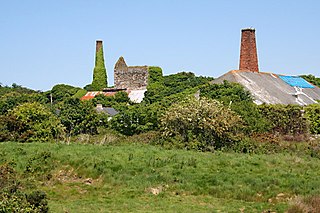
Great Wheal Charlotte, also known as Wheal Charlotte, is an abandoned copper and tin mine lying between St Agnes and Porthtowan in Cornwall, England. All that is left of the mine now is the wall and door arch of an engine house and an adjacent fenced-off mine shaft. The surviving wall is surrounded by rock debris and the extensive remains of spoil tips, mostly of bare rock fragments crisscrossed by paths that link the South West Coast Path with surrounding land owned by the National Trust. Predominantly a copper producer, in its heyday, in the 1830s, the mine extracted ore containing 7.25% copper. It may have partially closed around 1840. However, ore production was high in this year, and records of output extend at least to 1856, and possibly to 1863.
Wheal Maid is a former mine in the Camborne-Redruth-St Day Mining District, 1.5 km east of St Day.

