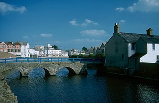
Boscastle to Widemouth

Last updated

Boscastle to Widemouth
Site of Special Scientific Interest
High Cliff, Cornwall.jpg
High Cliff, showing the characteristic slumping creating an undercliff
Cornwall UK location map.svg
Red pog.svg
Location within Cornwall
Location Cornwall
Grid reference SX165993
Coordinates 50°45′53″N4°36′10″W / 50.7646°N 4.6027°W / 50.7646; -4.6027
InterestBiological/Geological
Area639 hectares (6.390 km2; 2.467 sq mi)
Notification 1972 (1972)
Natural England website

Boscastle to Widemouth is a coastal Site of Special Scientific Interest (SSSI) in Cornwall, England, noted for its biological and geological characteristics. The Dizzard dwarf oak woodland is unique and of international importance for its lichen communities, with 131 species recorded. [1]

Contents

Geography

The 639-hectare (1,580-acre) site is located on the north Cornish coast, by the Celtic Sea of the Atlantic Ocean. The 12 miles (19 km) length of coastline stretches from Boscastle in the south to Widemouth Bay to the north. [2] [3] The coast on either side of Crackington Haven is characterised by the cliffs collapsing and rather than having steep vertical slopes such as in west Cornwall, there is a series of 'undercliffs' which are thickly vegetated. Some are grazed by cattle and horses and the resulting mosaic of semi–natural habitats is of national importance for the coastal heath and grassland. High Cliff (grid reference SX125943 ) at 223 metres (732 ft) is the highest cliff in Cornwall. [4]

The South West Coast Path runs through the SSSI, parts of the coast are owned and managed by the National Trust and five Geological Conservation Review sites are within the area. [3] [5]

Geology

The coast between Boscastle and Widemouth is characterised by high slumped cliffs leading to areas of thickly vegetated, sloping lower undercliffs. The underlying rock, a type of shale which is easily fractured, is known to geologists as the Crackington formation and the layered strata contorted by earth movements can best be seen at Crackington Haven and Millook. [4] The rocks date to the Namurian stage roughly 326 to 313 Ma (million years ago) and were folded during the Variscan orogeny a period of mountain building caused by the collision of two continents. [5]

During the Quaternary Period the area was covered in periglacial deposits called head. At the time the area was tundra and was just to the south of an ice sheet which covered most of Britain. [1]

There are five Geological Conservation Review sites within the SSSI. [1] They are:-

Wildlife and ecology

The valleys at Crackington Haven, Cleave, Dizzard and Millook show good examples of the zonation of habitats from splash zone lichen communities, to cliff vegetation with maritime grass, heath and scrub into woodland communities. [1] [5]

Sea cliff vegetation

In the splash zone at and above the high water mark there are black, orange and grey coloured lichen zones. Verrucaria species such as V. maura are black; Xanthoria parietina and Caloplaca marina are bright yellow and orange; Lecanora atra is grey; and Ramalina siliquosa is green. Rock samphire ( Crithmum maritimum ) is found on rock ledges and crevices, 6–10 m above the high water mark along with sea spleenwort ( Asplenium marinum ), common scurvy-grass ( Cochlearia officinalis ), buck's-horn plantain ( Plantago coronopus ), thrift ( Armeria maritima ) and rock sea-spurrey ( Spergularia rupicola ). Cliff breeding birds along the coast are fulmar ( Fulmarus glacialis ), shag ( Gulosus aristotelis ), kestrel ( Falco tinnunculus ), peregrine ( Falco peregrinus ), raven ( Corvus corax ) and rock pipit ( Anthus petrosus ). The chough ( Pyrrhocorax pyrrhocorax ), last bred on the north Cornwall coast in 1952 and is currently breeding in the Land's End and Lizard areas.

Maritime grassland

Soil accumulates where the slope is not too steep and herb rich coastal grassland communities develop. The dominant grass is red fescue and the flowering plants include bird's–foot trefoil ( Lotus corniculatus ), wild thyme ( Thymus serpyllum ), wild carrot ( Daucus carota ), sea campion ( Silene maritima ), spring squill ( Scilla verna ) and kidney vetch ( Anthyllis vulneraria ).

Maritime heath

A feature of coastal heaths is the undulating or waved appearance caused by the exposure to winds. A good example is at Aller Shoot, a valley to the north of Crackington Haven. The taller species are heather ( Calluna vulgaris ), bell heather ( Erica cinerea ) and western gorse ( Ulex gallii ). Growing amongst these plants are bristle bent ( Agrostis curtisii ), red fescue ( Festuca rubra ), sheep's–bit ( Jasione montana ), tormentil ( Potentilla erecta ) and lousewort ( Pedicularis sylvatica ).

Scrub

The dominant species of scrub depend on previous land management with varying amounts of blackthorn ( Prunus spinosa ), European gorse ( Ulex europaeus ), bramble ( Rubus fruticosus ), wild privet ( Ligustrum vulgare ) and bracken ( Pteridium aquilinum ). Amongst the leaf litter can be found Yorkshire fog ( Holcus lanatus ), honeysuckle ( Lonicera periclymenum ), bluebell ( Hyacinthoides non-scripta ) and wild madder ( Rubia peregrina ). Typical birds seen within the SSSI are stonechat ( Saxicola rubicola ), linnet ( Carduelis cannabina ) and whitethroat ( Sylvia communis ).

Dizzard woodland

The woodland is between Crackington Haven and Millook and runs for approximately 2 miles (3.2 km) between the coastal path and the shore. [6] Of international importance for its lichen communities, the ″dwarf ″ woodland at Dizzard Point (grid reference SX165993 ) grows on exposed, unstable cliffs with a canopy dominated by sessile oak ( Quercus petraea ). Other woodland trees recorded are pedunculate oak ( Q. robur ), rowan ( Sorbus aucuparia ) and wild service-tree ( S. torminalis ). The maximum height of the canopy is from one to eight metres depending on exposure to the salt–laden, unpolluted winds and the trees are covered with Lobarion communities of lichens; the main species are Lobaria pulmonaria , Lobaria scrobiculata , Parmeliella atlantica , Parmeliella plumbea and Pseudocyphellaria crocata , which is known from only one other site in England and Wales. Other lichens rarities include Bombyliospora pachycarpa , Graphina ruiziana , Lecidea carollii , Melaspilea ochrothalmia and Pannaria rubiginosa . The ground flora consists of a base rich plant community with ramsons ( Allium ursinum ), lords and ladies ( Arum maculatum ) and meadowsweet ( Filipendula ulmaria ) in the wetter areas. Otherwise the ground flora is heath-like with ling ( Calluna vulgaris ) and bilberry ( Vaccinium myrtillus ) as the dominant species, and cow wheat ( Melampyrum pratense ) and hay-scented buckler-fern ( Dryopteris aemula ) also occurring. Management by the National Trust includes the removal of invasive sycamore ( Acer pseudoplatanus ) and maintenance of the coastal footpath from where the wood can be observed as there is no public access. [4] [5]

Large blue butterfly

The discovery of the large blue butterfly ( Phengaris arion ) at Millook by E A Waterhouse in 1891 was described as both unexpected and remarkable. It had been extinct in Northamptonshire for thirty years and was declining in areas such as the Cotswolds and along the south coast of Devon. It had probably been overlooked in isolated Cornwall until just before the coming of the railways to Camelford in 1893 and to Bude in 1898. The butterfly was found to inhabit valleys as far west as Tintagel and in some places found in great abundance, which led to some collectors visiting year after year and taking hundreds for collections. Not surprisingly by 1925 the species was in decline, although not solely due to collecting. In 1902 many acres of the original habitat at Millook had been enclosed and ploughed, and P M Bright noted how since 1911 "the gorse has been allowed to grow up over the whole area ... especially in the neighbourhood of Millook. This has choked out its ( food plant ) in many places where it was abundant, and has also driven away the ants". The temporary demise of rabbits ( Oryctolagus cuniculus ) caused by the rapid spread of myxomatosis after its introduction in 1953 would also have led to the spread of gorse, and in that year Millook valley was described as "by then totally overgrown and without a vestige of wild thyme, but several other localities, including parts of Crackington Haven, appeared to be, and in fact still are much less obviously changed". In 1963 a search of twenty-three sites in Cornwall found only eight small colonies left, all to the north of Bude and thus outside the area of this SSSI; the large blue was last seen in Cornwall in 1973 (although it was introduced to a north Cornwall site in 2000). [7] [8]

Related Research Articles

<span class="mw-page-title-main">South West Coast Path</span> Long-distance footpath in England

<span class="mw-page-title-main">Bude</span> Town in Cornwall, England

Bude is a seaside town in north east Cornwall, England, in the civil parish of Bude-Stratton and at the mouth of the River Neet. It was sometimes formerly known as Bude Haven. It lies southwest of Stratton, south of Flexbury and Poughill, and north of Widemouth Bay, located along the A3073 road off the A39. Bude is twinned with Ergué-Gabéric in Brittany, France. Bude's coast faces Bude Bay in the Celtic Sea, part of the Atlantic Ocean. The population of the civil parish can be found under Bude-Stratton.

<span class="mw-page-title-main">North Cornwall</span> Area of Cornwall, England

North Cornwall is an area of Cornwall, England, United Kingdom. It is also the name of a former local government district, which was administered from Bodmin and Wadebridge 50.516°N 4.835°W. Other towns in the area are Launceston, Bude, Padstow, and Camelford.

<span class="mw-page-title-main">Crackington Haven</span> Village in Cornwall, England

<span class="mw-page-title-main">Aire Point to Carrick Du SSSI</span> Site of Special Scientific Interest in Cornwall, England

Aire Point to Carrick Du SSSI is a Site of Special Scientific Interest on the Penwith Peninsula, Cornwall, England. It is 5.98 square kilometres in extent, stretching from grid reference SW360279 to grid reference SW513410. The site is designated both for its biological and its geological interest.

<span class="mw-page-title-main">Gugh</span> Tidal island of the isles of Scilly

Gugh could be described as the sixth inhabited island of the Isles of Scilly, but is usually included with St Agnes with which it is joined by a sandy tombolo known as "The Bar" when exposed at low tide. The island is only about 1 km (0.62 mi) long and about 0.5 km (0.31 mi) wide, with the highest point, Kittern Hill at 34 m (112 ft). The geology consists of Hercynian granite with shallow podzolic soils on the higher ground and deeper sandy soils on the lower ground. The former Gugh farm is just north of the neck across the middle of the island between the two hills. The two houses were designed and built in the 1920s by Charles Hamlet Cooper.

<span class="mw-page-title-main">Lambert's Castle</span> Historic hill fort in Dorset, England

Lambert's Castle is an Iron Age hillfort in the county of Dorset in southwest England. Since 1981 it has been designated as a Site of Special Scientific Interest (SSSI) on account of its geology, archaeology and ecology. The hillfort is designated a scheduled monument together with a bowl barrow, the sites of a post-medieval fair and a telegraph station. The site was on the Heritage at Risk Register but was removed in 2022 as a result of the Hillforts and Habitats Project.

<span class="mw-page-title-main">Gwennap Head</span> Headland in Cornwall, England

Gwennap Head is a headland on the south coast of the Penwith peninsula, Cornwall, United Kingdom. It is within the parish of St Levan and approximately 4 miles (6.4 km) south of Land's End, and less than 1 mile (1.6 km) north-west of Porthgwarra, the nearest village. The area of Gwennap Head is designated as part of the Penwith Heritage Coast and also designated as part of the Cornwall Area of Outstanding Natural Beauty. The South West Coast Path closely follows the coastline around the headland.

<span class="mw-page-title-main">Geology of Cornwall</span>

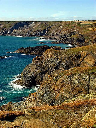
The geology of Cornwall, England, is dominated by its granite backbone, part of the Cornubian batholith, formed during the Variscan orogeny. Around this is an extensive metamorphic aureole formed in the mainly Devonian slates that make up most of the rest of the county. There is an area of sandstone and shale of Carboniferous age in the north east, and the Lizard peninsula is formed of a rare section of uplifted oceanic crust.

<span class="mw-page-title-main">Flora and fauna of Cornwall</span>

Cornwall is the county that forms the tip of the southwestern peninsula of England; this area has a mild and warm climate regulated by the Gulf Stream. The mild climate allows rich plant cover, such as palm trees in the far south and west of the county and in the Isles of Scilly, due to sub-tropical conditions in the summer.

<span class="mw-page-title-main">St Gennys</span>

<span class="mw-page-title-main">White Island, Isles of Scilly</span> Island of Great Britain

White Island is one of the larger unpopulated islands of the Isles of Scilly, part of the United Kingdom, and lies off the coast of the northernmost populated island of the group, St Martin's, to which it is joined by a tidal causeway, or isthmus. The island is designated as a Site of Special Scientific Interest (SSSI) and a Geological Conservation Review site and is managed by the Isles of Scilly Wildlife Trust on behalf of the Duchy of Cornwall.

<span class="mw-page-title-main">Treen Cliff</span> Site of Special Scientific Interest on the Penwith Peninsula in Cornwall, England

Treen Cliff is a Site of Special Scientific Interest (SSSI) located on the Penwith Peninsula in Cornwall, England, UK, 6 miles (9.7 km) south-west of Penzance. First notified in 1951, with a revision in 1973, and a further notification on 1 July 1986, it is 49.3 hectares in area, stretching from grid reference SW387220 to SW402225. Designated for both for its biological and geological interest, part of the site, Treryn Dinas, is a Scheduled Ancient Monument consisting of a "cliff castle" with four ramparts and ditches and the Logan Rock. It is within the Cornwall Area of Outstanding Natural Beauty (AONB), the Penwith Heritage Coast and is part owned and managed by the National Trust.

<span class="mw-page-title-main">Dizzard</span>

Dizzard is an area, in the civil parish of St Gennys, Cornwall, containing five farms. On the coast is Dizzard Point, and the unique, dwarf oak, Dizzard Wood, which is of international importance for its lichen communities.

<span class="mw-page-title-main">Millook</span> Hamlet in Cornwall, England

Millook is a deep coastal valley and hamlet in the parish of Poundstock, on the north coast of Cornwall, England.

<span class="mw-page-title-main">Caerthillian to Kennack</span> Coastal Site of Special Scientific Interest in Cornwall, England

Caerthillian to Kennack is a coastal Site of Special Scientific Interest (SSSI) on the Lizard Peninsula in Cornwall, UK, noted for both its biological and geological characteristics. It is of great botanical importance, with several Red Data Book of rare and endangered plant species being found on the site, as well as a breeding site for Cornish choughs.

<span class="mw-page-title-main">Steeple Point to Marsland Mouth</span> Coastal Site of Special Scientific Interest in Cornwall, England

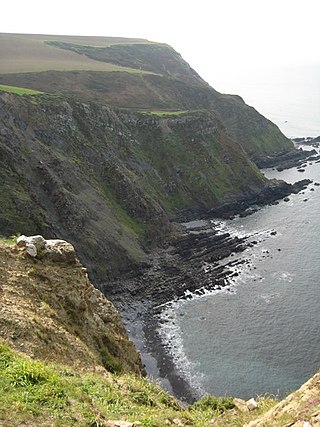
Steeple Point to Marsland Mouth is a coastal Site of Special Scientific Interest (SSSI) in Cornwall, England, UK, noted for its biological characteristics.

<span class="mw-page-title-main">Wingletang Down (St Agnes)</span>

Wingletang Down is a Site of Special Scientific Interest (SSSI) on the southern side of the island of St Agnes in the Isles of Scilly, England, UK, which is noted for its biological characteristics. The site is managed by the Isles of Scilly Wildlife Trust and is within the Isles of Scilly Heritage Coast and the Isles of Scilly Area of Outstanding Natural Beauty. It is the only site in Great Britain and Ireland for the small fern, least adder's–tongue. As of 11 September 2009 the SSSI was considered to be in ″unconditional recovering″ condition because European gorse and bramble are at unacceptable levels.

<span class="mw-page-title-main">Godrevy Head to St Agnes</span>

Godrevy Head to St Agnes is a coastal Site of Special Scientific Interest (SSSI) in north Cornwall, England], noted for both its biological and geological characteristics. A number of rare and scarce plant species can be found on the site, along with many breeding seabirds.

<span class="mw-page-title-main">Rosenannon Downs</span> Nature reserve in mid Cornwall, England

Rosenannon Downs is a nature reserve in mid Cornwall, England, UK, being designated Rosenannon Bog and Downs Site of Special Scientific Interest (SSSI), noted for its biological characteristics. The site supports a wide variety of flora and fauna and includes Bronze Age barrows. Conservation work is carried out on the site by the owners, the Cornwall Wildlife Trust.

References

  1. 1 2 3 4 Hughes, Michel; Tonkin, Beth (June 1997). The Culm Natural Area. English Nature. p. 72.
  2. "Boscastle to Widemouth map". Natural England. Archived from the original on 12 October 2012. Retrieved 17 November 2011.
  3. 1 2 Ordnance Survey: Landranger map sheet 190 Bude & Clovelly ISBN   978-0-319-23145-6
  4. 1 2 3 Le Messurier, Brian; Luck, Liz (2001). Crackington Haven (third ed.). National Trust. p. 8.
  5. 1 2 3 4 "Boscastle to Widemouth" (PDF). Natural England. 1990. Retrieved 17 November 2011.
  6. Miles, Archie (2007). Hidden Trees of Britain. Ebury Publishing.
  7. Penhallurick, Roger (1996). The Butterflies of Cornwall and the Isles of Scilly. Truro: Dyllansow Pengwella. ISBN   0-9515785-1-0.
  8. Smith, Frank (2003). The Moths and Butterflies of Cornwall and the Isles of Scilly. Wallingford: Gem Publishing Company. ISBN   0-906802-07-5.