The River Fowey is a river in Cornwall, England, United Kingdom.

The Hayle Estuary and Carrack Gladden SSSI is a Site of Special Scientific Interest, noted for its biological interest, in west Cornwall, England, UK. It consists of three distinct parts, each of which is covered in a separate article: the Hayle Estuary, the sand-dune system of Porth Kidney Sands and the coastal headland at Carrack Gladden.
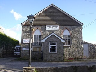
Breage is a village and civil parish in Cornwall, England, United Kingdom. The village is 3 miles (5 km) west of Helston.

Mining in Cornwall and Devon, in the southwest of Britain, is thought to have begun in the early-middle Bronze Age with the exploitation of cassiterite. Tin, and later copper, were the most commonly extracted metals. Some tin mining continued long after the mining of other metals had become unprofitable, but ended in the late 20th century. In 2021, it was announced that a new mine was extracting battery-grade lithium carbonate, more than 20 years after the closure of the last South Crofty tin mine in Cornwall in 1998.

Caradon Hill is on Bodmin Moor in the former Caradon district of Cornwall, England, United Kingdom. The summit is 371 metres (1,217 ft) above mean sea level. Caradon Hill is on the southeastern edge of the moor; it is between the villages of Minions (northwest), Upton Cross (northeast), Pensilva (southeast) and Darite (southwest).
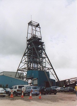
South Crofty is a metalliferous tin and copper mine located in the village of Pool, Cornwall, England. An ancient mine, it has seen production for over 400 years, and extends almost two and a half miles across and 3,000 feet (910 m) down and has mined over 40 lodes. Evidence of mining activity in South Crofty has been dated back to 1592, with full-scale mining beginning in the mid-17th century. The mine went into serious decline after 1985 and eventually closed in 1998. After several changes of ownership, South Crofty is owned by Cornish Metals Inc, which is working to re-open the mine, as of November 2022, having received a permit for dewatering the mine.
Minions is a village in Cornwall, England, United Kingdom. It is situated on the eastern flank of Bodmin Moor northwest of Caradon Hill approximately four miles (6 km) north of Liskeard. Minions is first recorded in 1613 and its meaning is unknown.

Wheal Gorland was a metalliferous mine located just to the north-east of the village of St Day, Cornwall, in England, United Kingdom. It was one of the most important Cornish mines of the late 18th and early 19th centuries, both for the quantity of ore it produced and for the wide variety of uncommon secondary copper minerals found there as a result of supergene enrichment. It is the type locality for the minerals chenevixite, clinoclase, cornwallite, kernowite and liroconite.

Pensilva is a village in the civil parish of St Ive and Pensilva, in east Cornwall, England, United Kingdom. It is at OS grid ref SX291697 about four miles (6 km) northeast of Liskeard. Nearby settlements include Charaton Cross and Middlehill.

Crow's Nest is a village in Cornwall, England. It is located within the civil parish of St Cleer, on the southeastern edge of Bodmin Moor, 3 miles (4.8 km) north of the town of Liskeard.

Holmbush is a village in Cornwall, England that is situated in the suburban area of St Austell. It was a centre for tin and copper mining in the eighteenth and nineteenth centuries, with a few houses to the south of the A390 road. It was developed in the 1970s, with the construction of housing and an industrial estate to the north of the road. Since 1974, the site of Cuddra mine has been developed as Pinetum Gardens, an attraction holding over 6,000 varieties of plants, many collected by the owner on plant hunting expeditions.

Rinsey is a hamlet in the civil parish of Breage, in Cornwall, England, United Kingdom. It is located off the main A394 road between Helston and Penzance. The nearby hamlet of Rinsey Croft is located 1 km to the north-east. The nearby cliffs and beach are owned and managed by the National Trust and part of Rinsey East Cliff is designated as the Porthcew Site of Special Scientific Interest (SSSI) for its geological interest. The South West Coast Path passes through the property. Rinsey lies within the Cornwall Area of Outstanding Natural Beauty (AONB).
Wheal Fortune or Great Wheal Fortune is the site of a mine in the civil parishes of Breage and Sithney in west Cornwall. Part of the disused mine was designated as a Site of Special Scientific Interest (SSSI) for its geological interest in 1991 and is also a Geological Conservation Review site of national importance for the minerals on the site.
Mulberry Downs Quarry is a disused opencast tin mine in Cornwall, England, UK. Today the site is described as a 'chasm' being a steep or sheer-sided pit 700 foot (210 m) long and up to 100 foot (30 m) deep, and the quarry and immediate surroundings are heavily wooded. The quarry was designated as a Site of Special Scientific Interest (SSSI) in 1973 for its geological interest.

The West Cornwall Bryophytes Site of Special Scientific Interest is a group of seven locations of former mining activity, that form a single SSSI and Important Plant Area in western Cornwall, England, United Kingdom. The site is noted for its biological characteristics and derives its name from the rare bryophyte species found there.
Calaminarian grassland is grassland where the process of seral succession has been halted due to the toxicity of soils containing high levels of toxic metal ions. These habitats may be semi-natural on naturally exposed deposits, or the result of mining, or from erosion by rivers, sometimes including washed-out mine workings.
Ditrichum cornubicum, commonly known as the Cornish path-moss, is a moss endemic to Cornwall, United Kingdom. First discovered in 1963, on a roadside west of Lanner, Cornwall by Jean Paton, it has since been found in two other places within Cornwall. It was published as new to science in 1976.

Basset Mines was a mining company formed in Cornwall, England, by the amalgamation of six copper and tin mining setts. It operated from 1896 until 1918, when it was closed due to a fall in the price of tin.
Presented below is an alphabetical index of articles related to Cornwall: