
The Tamar is a river in south west England, that forms most of the border between Devon and Cornwall. A part of the Tamar valley is a World Heritage Site due to its historic mining activities.

The River Lynher flows through east Cornwall, England, and enters the River Tamar at the Hamoaze, which in turn flows into Plymouth Sound.
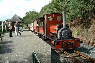
The Launceston Steam Railway is a 1 ft 11+1⁄2 in narrow gauge railway, in Cornwall, England. The railway operates from the town of Launceston to Newmills, where there is a farm park; it is 2+1⁄2 miles (4.0 km) long. The railway is built on the trackbed of the former standard gauge North Cornwall Railway.
Newport is a suburb of the town of Launceston in Cornwall, England, United Kingdom. Originally a separate settlement, Newport is immediately north of the town from which it is separated by the River Kensey.
Broadwoodwidger was a rural district in the administrative county of Devon from 1894 to 1966, northeast of Launceston. The district consisted of part of the Launceston rural sanitary district in Devon. The remainder of the sanitary district became Launceston Rural District in Cornwall.

Whitstone is a village and civil parish in east Cornwall, United Kingdom. It is roughly halfway between the towns of Bude and Launceston. The population at the 2011 census was 590.
Drakewalls is a small village in southeast Cornwall, England, UK. It is in Calstock parish, adjacent to Gunnislake between Callington and Tavistock.

Werrington is a civil parish and former manor now in Cornwall, England, United Kingdom. Prior to boundary changes it straddled the Tamar and lay within the county of Devon. The portion on the west side was transferred to Cornwall in 1966. It is situated 1 mile (1.6 km) to the west of the Tamar, the traditional boundary between Devon and Cornwall, and 1 mile (1.6 km) north of Launceston.
The River Inny is a small river in east Cornwall, United Kingdom. It is a tributary of the River Tamar and is about twenty miles (32 km) long from its source near Davidstow on the eastern flank of Bodmin Moor to its confluence with the Tamar at Inny Foot near Dunterton.

North Tamerton is a village and civil parish in east Cornwall, England, UK. The village is situated approximately eight miles (13 km) southeast of Bude and eight miles (13 km) north of Launceston.

St Stephens by Launceston Rural is a civil parish in the east of Cornwall, England, United Kingdom. It is in the Registration district of Launceston. The population of the parish in the 2001 census was 312, increasing to 360 and including Dutson at the 2011 census. The former parish of St Stephens by Launceston was abolished in 1894: St Stephens by Launceston Urban became part of the town of Launceston, while St Stephens by Launceston Rural became part of Launceston Rural District.
St Thomas the Apostle Rural, also known as St Thomas-by-Launceston is a civil parish in east Cornwall, England, United Kingdom. It is centred on the village of Tregadillett and is in the Registration District of Launceston.

The River Ottery is a small river in northeast Cornwall, United Kingdom. The river is about twenty miles (32 km) long from its source southeast of Otterham to its confluence with the River Tamar at Nether Bridge, two miles (3.2 km) northeast of Launceston.

Luckett is a hamlet in east Cornwall, England. It is situated in a former mining area beside the River Tamar approximately three miles (5 km) north of Callington. According to the Post Office the population at the 2011 census was included in the civil parish of Stokeclimsland

St Dominic is a civil parish and village in Cornwall, England, United Kingdom. The village is situated 2+1⁄2 miles (4.0 km) east of Callington and five miles (8 km) north of Saltash.
Wilcove is a small coastal village in Cornwall, England, United Kingdom. It is situated one mile (1.6 km) north of Torpoint and one mile (1.6 km) west of Devonport across the Hamoaze, the tidal estuary of the River Tamar.
Launceston Priory was a priory at Newport, Launceston, Cornwall, England, UK.

Launceston is a town, ancient borough, and civil parish in Cornwall, England, United Kingdom. It is 1 mile (1.6 km) west of the middle stage of the River Tamar, which constitutes almost the entire border between Cornwall and Devon. The landscape of the town is generally steep particularly at a sharp south-western knoll topped by Launceston Castle. These gradients fall down to the River Kensey and smaller tributaries.

The River Seaton is a river in east Cornwall, England, UK which flows southwards for 11 miles (17 km) into the English Channel.

The River Lerryn is a river in east Cornwall, England, UK, a tributary of the River Fowey. The Lerryn is the largest of the tributaries which enter the estuary of the Fowey. The river is tidal up to the village of Lerryn. The landscape of the Lerryn catchment is rural and includes heathland, moorland and rough pasture in the upper reaches and broadleaf, coniferous and mixed plantation woodland in the lower. This catchment includes four SSSIs, including Redlake Meadows & Hoggs Moor. The Lerryn rises at Fairy Cross on the southern slopes of Bodmin Moor and flows south-southwest until it enters the Fowey estuary.
