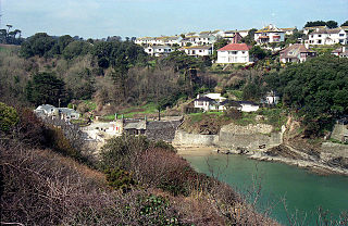
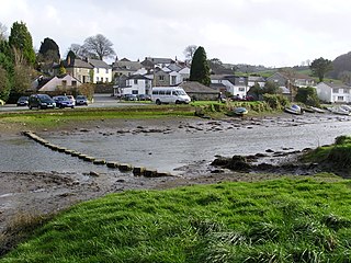
The River Lerryn at low tideThe River Lerryn at Tallowater
The River Lerryn is a river in east Cornwall, England, UK, a tributary of the River Fowey. The Lerryn is the largest of the tributaries which enter the estuary of the Fowey. The river is tidal up to the village of Lerryn. The landscape of the Lerryn catchment is rural and includes heathland, moorland and rough pasture in the upper reaches and broadleaf, coniferous and mixed plantation woodland in the lower. This catchment includes four SSSIs, including Redlake Meadows & Hoggs Moor.[1] The Lerryn rises at Fairy Cross (Grid ref. SX1262) on the southern slopes of Bodmin Moor and flows south-southwest until it enters the Fowey estuary (Grid ref. SX1255).[2]
The name of the river is Cornish; the earliest record of it is as "Leryan" and "Lerion" in 1289. In modern Cornish its name would be Dowr Leryon, meaning "river of floods".[3] The village of Lerryn is named after the river.
Bodmin Moor is a granite moorland in northeastern Cornwall, England. It is 208 square kilometres (80 sq mi) in size, and dates from the Carboniferous period of geological history. It includes Brown Willy, the highest point in Cornwall, and Rough Tor, a slightly lower peak. Many of Cornwall's rivers have their sources here. It has been inhabited since at least the Neolithic era, when primitive farmers started clearing trees and farming the land. They left their megalithic monuments, hut circles and cairns, and the Bronze Age culture that followed left further cairns, and more stone circles and stone rows. By medieval and modern times, nearly all the forest was gone and livestock rearing predominated.
The River Fowey is a river in Cornwall, England, United Kingdom.
The River Camel is a river in Cornwall, United Kingdom. It rises on the edge of Bodmin Moor and with its tributaries its catchment area covers much of North Cornwall. The river flows into the eastern Celtic Sea between Stepper Point and Pentire Point having covered about 30 miles, making it the second longest river wholly in Cornwall. The river is tidal upstream to Egloshayle and is popular for sailing, birdwatching and fishing. The name Camel comes from the Cornish language for 'the crooked one', a reference to its winding course. Historically the river was divided into three named stretches. Heyl was the name for the estuary up to Egloshayle, the River Allen was the stretch between Egloshayle and Trecarne, whilst the Camel was reserved for the stretch of river between its source and Trecarne.
The River Lynher flows through east Cornwall, England, and enters the River Tamar at the Hamoaze, which in turn flows into Plymouth Sound.
The River Fal flows through Cornwall, England, rising at Pentevale on Goss Moor and reaching the English Channel at Falmouth. On or near the banks of the Fal are the castles of Pendennis and St Mawes as well as Trelissick Garden. The River Fal separates the Roseland peninsula from the rest of Cornwall. Like most of its kind on the south coast of Cornwall and Devon, the Fal estuary is a classic ria, or drowned river valley. The Fal estuary from Tregony to the Truro River was originally called Hafaraell.
The Saints' Way is an ancient trackway and long-distance footpath in mid Cornwall, England, UK.
Readymoney Cove is a sandy beach to the south of the harbour town of Fowey, Cornwall, England, United Kingdom. It is sheltered by cliffs close to the mouth of the River Fowey estuary and bounded, on one side, by the medieval part of the town of Fowey and, on the other, by St Catherine's Castle. The beach can be covered during spring tides. The beach is cleaned daily during high season, and a bathing platform is moored in the bay. Dogs are banned between Easter and 30 September. Above the cove is the former coach house which was the home of author, Daphne du Maurier, for a few years during the Second World War. Comedian Dawn French lives in a house overlooking the cove.
St Veep is a civil parish in Cornwall, England, United Kingdom, situated above the east bank of the River Fowey about three miles (5 km) south-east of Lostwithiel. It is bordered by the parishes of St Winnow to the north-west, Boconnoc to the north, Lanreath to the east Polperro to the south-east and Lanteglos to the south. The River Fowey forms its western boundary. The parish is named after Saint Veep of whom little is known.
Lerryn is a village in Cornwall, United Kingdom. It is situated on the River Lerryn approximately three miles (5 km) southeast of Lostwithiel.
Caradon Hill is on Bodmin Moor in the former Caradon district of Cornwall, England, United Kingdom. The summit is 371 metres (1,217 ft) above mean sea level. Caradon Hill is on the southeastern edge of the moor; it is between the villages of Minions (northwest), Upton Cross (northeast), Pensilva (southeast) and Darite (southwest).
The Par River, also known as the Luxulyan River is a river draining the area north of St Blazey in Cornwall, in the United Kingdom.
The River Inny is a small river in east Cornwall, United Kingdom. It is a tributary of the River Tamar and is about twenty miles (32 km) long from its source near Davidstow on the eastern flank of Bodmin Moor to its confluence with the Tamar at Inny Foot near Dunterton.
The River Menalhyl is a river in Cornwall, England, that flows through the civil parishes of St Columb Major and Mawgan-in-Pydar. Its length is about 12 miles and it flows in a generally north-west direction. The name comes from the Cornish words melyn meaning mill and heyl meaning estuary - estuary mills. The name was recorded as Mellynheyl in the 19th century, but it had been known as Glyvion.
Trewen is a hamlet and a civil parish in east Cornwall, England, United Kingdom The parish is just east of Bodmin Moor in the River Inny valley and lies in the Registration District of Launceston.
Warleggan or Warleggon is a civil parish on the southern edge of Bodmin Moor in Cornwall, England, United Kingdom.
Pensilva is a village in the civil parish of St Ive and Pensilva, in east Cornwall, England, United Kingdom. It is at OS grid ref SX291697 about four miles (6 km) northeast of Liskeard. Nearby settlements include Charaton Cross and Middlehill.
The River Ottery is a small river in northeast Cornwall, United Kingdom. The river is about twenty miles (32 km) long from its source southeast of Otterham to its confluence with the River Tamar at Nether Bridge, two miles (3.2 km) northeast of Launceston.
The De Lank River is a small river in north Cornwall, England. It is a tributary of the River Camel and is approximately nine miles (14.5 km) long from its source on Bodmin Moor to its confluence with the Camel two miles (3 km) south of St Breward.
Colliford Lake is a reservoir on Bodmin Moor, Cornwall, England, United Kingdom. Covering more than 900 acres (3.6 km2), it is the largest lake in Cornwall. It is situated south of the A30 trunk road near the village of Bolventor, the approximate centre of the lake being at OS grid reference SX179730. Dozmary Pool outfalls into the lake and the lake's own outfall forms one of the tributaries of the River Fowey.
The St Austell River properly known as the River Vinnick, but historically called The White River, is a 12 kilometres (7.5 mi) long river located in south Cornwall, England, United Kingdom. 50.337°N 4.793°W. The river has also been known as the "red river" due to tin streaming and mining activity upstream.
This page is based on this Wikipedia article Text is available under the CC BY-SA 4.0 license; additional terms may apply. Images, videos and audio are available under their respective licenses.