River Menalhyl

Last updated
River Menalhyl
The River Menalhyl - geograph.org.uk - 105315.jpg
River Menalhyl at St Columb Major
Native nameDowr Melynheyl  (Cornish)
Location
Country England
Region Cornwall
Physical characteristics
Source 
  location Nine Maidens
  coordinates 50°28′15″N4°54′36″W / 50.47083°N 4.91000°W / 50.47083; -4.91000
  elevation150 m (490 ft)
Mouth  
  location
Mawgan Porth, Celtic Sea
  coordinates
50°28′0″N5°2′0″W / 50.46667°N 5.03333°W / 50.46667; -5.03333 Coordinates: 50°28′0″N5°2′0″W / 50.46667°N 5.03333°W / 50.46667; -5.03333
Length19 km (12 mi)

The River Menalhyl (Cornish : Dowr Melynheyl, meaning river of the estuary mill) is a river in Cornwall, England, that flows through the civil parishes of St Columb Major and Mawgan-in-Pydar. Its length is about 12 miles and it flows in a generally north-west direction. [1] The name comes from the Cornish words melyn meaning mill and heyl meaning estuary - estuary mills. [2] The name was recorded as Mellynheyl in the 19th century, but it had been known as Glyvion. [3]

Contents

Sources

The source of the river's longest branch is near Nine Maidens, about 2 miles to the north of St Columb, 50°26′49″N4°56′35″W / 50.447°N 4.943°W / 50.447; -4.943 , at a height of approximately 490 feet above mean sea level. The Menalhyl enters the sea at Mawgan Porth on the north coast of the county, 50°27′54″N5°01′37″W / 50.465°N 5.027°W / 50.465; -5.027 .

Tributaries

Tributaries to the river include one that rises between the village of Tregonetha and Castle an Dinas, and one whose source is south-east of Tregatillian. A smaller river, from Talskiddy, joins the Menalhyl a short distance from its mouth.

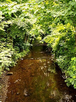
The river flows through the settlements of St Columb (the north part of the town, known as Bridge), St Mawgan and Mawgan Porth. Its valley, from St Columb downstream, is called the Vale of Lanherne; it is wooded for much of its length and is popular with walkers. [4]

Mills

There are a small number of disused mills along the length of the Menalhyl, and the river feeds some small lakes and ponds. It is also used for agricultural purposes along most of its course. Lawry's Mill was a tourist attraction in Victorian times and many postcards were produced featuring the Mill.

Fishing

The river is fished by anglers, especially in its lower course, and fish species such as brown trout, sea trout, lamprey, eel and minnow have been recorded. [1]

Geology

The bedrock of the catchment area largely consists of Devonian calcareous slates, grits and limestone. [1]

Commons-logo.svg Media related to River Menalhyl at Wikimedia Commons

Related Research Articles

River Fal River in Cornwall, England

The River Fal flows through Cornwall, England, rising at Pentevale on Goss Moor and reaching the English Channel at Falmouth. On or near the banks of the Fal are the castles of Pendennis and St Mawes as well as Trelissick Garden. The River Fal separates the Roseland peninsula from the rest of Cornwall. Like most of its kind on the south coast of Cornwall and Devon, the Fal estuary is a classic ria, or drowned river valley. The Fal estuary from Tregony to the Truro River was originally called Hafaraell.

Truro River River in Cornwall, England

The Truro River is a river in the city of Truro in Cornwall, England, UK. It is the product of the convergence of the two rivers named Kenwyn and Allen which run under the city: the Truro River flows into the River Fal, estuarial waters where wildlife is abundant, and then out into the Carrick Roads. The river is navigable up to Truro.

St Columb Major Human settlement in England

St Columb Major is a town and civil parish in Cornwall, England, United Kingdom. Often referred to locally as St Columb, it is approximately seven miles (11 km) southwest of Wadebridge and six miles (10 km) east of Newquay The designation Major distinguishes it from the nearby settlement and parish of St Columb Minor on the coast. An electoral ward simply named St Columb exists with a population at the 2011 census of 5,050. The town is named after the 6th-century AD Saint Columba of Cornwall, also known as Columb.

River Neath

River Neath is a river in south Wales running south west from the point at which its headwaters arising in the Brecon Beacons National Park converge to its mouth at Baglan Bay below Briton Ferry on the east side of Swansea Bay.

St Columb Minor Human settlement in England

St Columb Minor is a village on the north coast of Cornwall, England, United Kingdom.

Hundreds of Cornwall Historical administrative divisions of Cornwall, England

The hundreds of Cornwall were administrative divisions (hundreds) into which Cornwall, the present day administrative county of England, in the United Kingdom, was divided between c. 925 and 1894, when they were replaced with local government districts.

St Mawgan Village and civil parish in Cornwall, England

St Mawgan or St Mawgan in Pydar is a village and civil parish in Cornwall, England, United Kingdom. The population of this parish at the 2011 census was 1,307. The village is situated four miles northeast of Newquay, and the parish also includes the hamlet of Mawgan Porth. The surviving manor house known as Lanherne House is an early 16th-century grade I listed building. The nearby Royal Air Force station, RAF St Mawgan, takes its name from the village and is next to Newquay Cornwall Airport. The River Menalhyl runs through St Mawgan village and the valley is known as The Vale of Lanherne. It was the subject of a poem by poet Henry Sewell Stokes.

St Columb Canal

St Columb Canal sometimes referred to as Edyvean's Canal, was an abortive canal scheme in Cornwall, England, designed for the carriage of sea sand for use as manure. It was authorised in 1773, and part of it may have been briefly used around 1780.

Nanjizal

Nanjizal, also known as Mill Bay, is a beach and cove in the civil parish of St Levan, Cornwall, United Kingdom. Situated one mile to the south-east of Land's End, Nanjizal has no direct access via road, and is usually reached via the South West Coast Path from Land's End in the north, or from Porthgwarra to the south. Nanjizal is also a noted bird watching location.

Mawgan Porth

Mawgan Porth is a beach and small settlement in north Cornwall, England. It is north of Watergate Bay, approximately four miles (6 km) north of Newquay, on the Atlantic Ocean coast.

Par River, Cornwall River in Cornwall, England

The Par River, also known as the Luxulyan River is a river draining the area north of St Blazey in Cornwall, in the United Kingdom.

Arthur Ivan Rabey was best known as a Cornish historian and author from St Columb Major in Cornwall. He was also a journalist, broadcaster and local politician. In 1974 he was created a bard of The Cornish Gorseth and took the bardic name "Gwas Colum" meaning servant of St Columb. He died on 21 January 2008, aged 76, following a long illness.

Porth Reservoir A reservoir in Cormwall, England

Porth Reservoir is a reservoir in Cornwall, England, most of which is in the parish of Colan. The concrete dam was completed in 1960, and the lake has a net capacity of approximately 113,000,000 gallons.

Nankivell is a surname originating from Cornwall. Notable people with the surname include:

St Ives Bay Bay on the north coast of Cornwall, England

St Ives Bay is a bay on the Atlantic coast of north-west Cornwall, England, United Kingdom. It is in the form of a shallow crescent, some 4 miles or 6 km across, between St Ives in the west and Godrevy Head in the east.

Trenance

Trenance is a hamlet adjoining Mawgan Porth in Cornwall, England, United Kingdom. Trenance Point is a headland nearby.

John Arundell (1366–1435) Sheriff of Cornwall, Member of Parliament, Knight

John Arundell, called The Magnificent, of Lanherne in the parish of St Mawgan in Pydar in Cornwall, was an English knight who inherited large estates in the County of Cornwall. He was Sheriff of Cornwall and was one of Henry IV of England’s Kings Knights. In his will dated 1433, he bequeathed money for the preservation of the head of St Piran in the chapel at Perranzabuloe.

The following is a timeline of the history of St Columb Major, Cornwall, England, United Kingdom.

River Lerryn River in east Cornwall, England

The River Lerryn is a river in east Cornwall, England, UK, a tributary of the River Fowey. The Lerryn is the largest of the tributaries which enter the estuary of the Fowey. The river is tidal up to the village of Lerryn. The landscape of the Lerryn catchment is rural and includes heathland, moorland and rough pasture in the upper reaches and broadleaf, coniferous and mixed plantation woodland in the lower. This catchment includes four SSSIs, including Redlake Meadows & Hoggs Moor. The Lerryn rises at Fairy Cross on the southern slopes of Bodmin Moor and flows south-southwest until it enters the Fowey estuary.

References

  1. 1 2 3 "River Catchments – Menalhyl". Cornwall Rivers Project. Retrieved 23 June 2013.
  2. Weatherhill, Craig (1995). Cornish Place Names and Language. Sigma Leisure. ISBN   9781850584629.
  3. Weatherhill, Craig (2009). A Concise Dictionary of Cornish Place-Names. Evertype. ISBN   9781904808220.
  4. "Vale of Lanherne". Oliver's Cornwall. Retrieved 23 June 2013.