
Saint Austell is a town in Cornwall, England, United Kingdom, 10 miles (16 km) south of Bodmin and 30 miles (48 km) west of the border with Devon.

Par is a village and fishing port with a harbour on the south coast of Cornwall, England, United Kingdom. The village is situated in the civil parish of Tywardreath and Par, although West Par and the docks lie in the parish of St Blaise.

Lower Bostraze And Leswidden SSSI is a biological Site of Special Scientific Interest, located on the Penwith Peninsula, Cornwall, England, a little to the east of St Just, approximately 8 km west of Penzance.

London Apprentice is a village in south Cornwall, England, UK, on the banks of St Austell River in the Pentewan Valley approximately two miles (3 km) south of St Austell.
The Lansalson branch line was a railway line built by the Great Western Railway (GWR) to serve the china clay industry in the Trenance valley near St Austell in Cornwall, UK. The line was authorised by the GWR in 1910 and after setbacks due to World War I the line opened to Bojea Sidings on 1 May 1920 for mineral and goods traffic only, and to Lansalson Sidings on 24 May 1920. It closed in 1968.
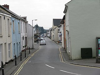
St Blazey is a small town in Cornwall, England, United Kingdom.
China stone is a medium grained, feldspar-rich partially kaolinised granite characterised by the absence of iron-bearing minerals.

St Dennis is a civil parish and village in Cornwall, England, United Kingdom. The village is situated on the B3279 between Newquay and St Austell.
Metakaolin is the anhydrous calcined form of the clay mineral kaolinite. Rocks that are rich in kaolinite are known as china clay or kaolin, traditionally used in the manufacture of porcelain. The particle size of metakaolin is smaller than cement particles, but not as fine as silica fume.

The Clay Trails are a series of bicycle trails located in mid Cornwall, England, United Kingdom. The trails pass through the St Austell moorland which for over two centuries has been extensively quarried for china clay, hence the name.
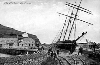
The Pentewan Railway was a 2 ft 6 in narrow gauge railway in Cornwall, England. It was built as a horse-drawn tramway carrying china clay from St Austell to a new harbour at Pentewan, and was opened in 1829. In 1874 the line was strengthened for locomotive working. It finally succumbed to more efficient operation at other ports and closed in 1918.

The geology of Cornwall, England, is dominated by its granite backbone, part of the Cornubian batholith, formed during the Variscan orogeny. Around this is an extensive metamorphic aureole formed in the mainly Devonian slates that make up most of the rest of the county. There is an area of sandstone and shale of Carboniferous age in the north east, and the Lizard peninsula is formed of a rare section of uplifted oceanic crust.

Nanpean is a village in the civil parish of St Stephen-in-Brannel in Cornwall, United Kingdom. The B3279 road runs through the village which is approximately 4 miles (6.4 km) north-west of St Austell in the heart of 'clay country', the china clay mining area of mid-Cornwall.

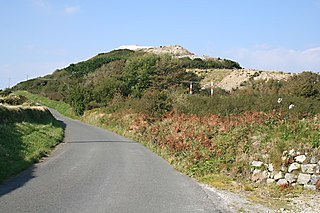
Pentewan is a coastal village and former port in south Cornwall, England, United Kingdom. It is situated at grid reference SX 019 472 3 miles (4.8 km) south of St Austell at the mouth of the St Austell River.

The Par River, also known as the Luxulyan River is a river draining the area north of St Blazey in Cornwall, in the United Kingdom.

The geography of Cornwall describes the extreme southwestern peninsula of England west of the River Tamar. The population of Cornwall is greater in the less extensive west of the county than the east due to Bodmin Moor's location; however the larger part of the population live in rural areas. It is the only county in England bordered by only one other county, Devon, and is the 9th largest county by area, encompassing 3,563 km2 (1,376 mi2). The length of the coast is large in proportion to the area of the county. Cornwall is exposed to the full force of the prevailing south-westerly winds that blow in from the Atlantic Ocean. To the north is the Celtic Sea, and to the south the English Channel.

Hemerdon Mine, also known as Hemerdon Ball Mine, Hemerdon Bal Mine and (briefly) previously as Drakelands Mine is a tungsten and tin mine. It is located 11 km northeast of Plymouth, near Plympton, in Devon, England. It lies to the north of the villages of Sparkwell and Hemerdon, and adjacent to the large china clay pits near Lee Moor. The mine had been out of operation since 1944, except for the brief operation of a trial mine in the 1980s. Work started to re-open it in 2014, but it ceased activities in 2018. It hosts the fourth largest tin-tungsten deposit in the world.

Pentewan Valley is one of four new civil parishes created on 1 April 2009 for the St Austell district of mid Cornwall, England, United Kingdom. The population including Gracca, Lavalsa Meor, London Apprentice and Lower Porthpean at the 2011 Census was 826.

The St Austell River properly known as the River Vinnick, but historically called The White River, is a 12 kilometres (7.5 mi) long river located in south Cornwall, England, United Kingdom. 50.337°N 4.793°W. The river has also been known as the "red river" due to tin streaming and mining activity upstream.
St Austell Clay Pits, are a group of locations within active china clay quarries that form a single Site of Special Scientific Interest (SSSI) and Special Area of Conservation, noted for its biological characteristics. In particular, the site is known for the rare western rustwort, a plant that grows only at two other sites in the UK.
