Treneglos

Last updated

Treneglos
Treneglos, Tregerry - geograph.org.uk - 556964.jpg
Tregerry, Treneglos [1]
Cornwall UK mainland location map.svg
Red pog.svg
Treneglos
Location within Cornwall
Population107 (Parish, 2011)
OS grid reference SX207881
Civil parish
  • Treneglos
Unitary authority
Ceremonial county
Region
Country England
Sovereign state United Kingdom
Post town LAUNCESTON
Postcode district PL15
Dialling code 01566
Police Devon and Cornwall
Fire Cornwall
Ambulance South Western
UK Parliament
List of places
UK
England
Cornwall
50°39′54″N4°32′17″W / 50.665°N 4.538°W / 50.665; -4.538

Treneglos (Cornish : Treneglos) is a village and a civil parish in north-east Cornwall, England, United Kingdom. It is in the Registration District of Launceston.

Contents

Treneglos is described as a village "where the old Cornish "trev" [settlement] is no more than a triangular green beside a church and two or three houses". It is above a wooded valley, a choice place where ancient Celtic tribes sought shelter. Nearby, at Wilsey Down, is evidence of prehistoric tumulus. Now, it is not unusual to see sheep wandering along the country roads. [2]

History

Treneglos, from "tre-an-eglos", means church, a particularly strong, solid church, or church town. [3] [4] The parish of Treneglos included Wilsey Down, on which were "four or five ancient barrows or tumuli". [5]

Tregulland Burrow

From an abstract of the journal article The Excavation of Tregulland Burrow, Treneglos Parish, Cornwall, Paul Ashbee's findings at the prehistoric Treneglos barrow are described as:

The ruined and gutted barrow called Tregulland Burrow, when totally excavated, proved to have had a complex structure. Stake holes denoting withdrawn stakes, an infilled 'ritual' pit, a satellite grave containing a cremation and arrowheads, and most probably the central grave pit, were the features of the first phase of its construction. A cairn-ring, with a buttressing bank, the soil for which was dug from an encircling ditch, and its turf covering, comprised the second. A great slab bearing cup-marks and an 'eyebrow' motif, also other lesser cup-marked and ornamented slabs, were incorporated in cairn-ring and bank. Cup-marked stones recovered from the disturbed central area suggested the one-time existence of a stone-built grave incorporating such elements. After this second phase the barrow centre was open and arena-like, and a food vessel and a cremation were put in close by the cairn-ring. All was finally enveloped by material from the depths of the ditch. Poorly built walling or turves retained the final mound. [6] [7]

St Gregory's Church

St Gregory's Church, Treneglos Treneglos, St Gregorys church - geograph.org.uk - 556992.jpg
St Gregory's Church, Treneglos

The parish was in the 12th century in the possession of Robert Fitz-William, Lord of Downinney (also Downeckney), who gave it to the priory of Tywardreath. [nb 1] Warbstow was then a chapelry dependent on Treneglos; the two benefices were later combined as a vicarage (united benefice). Robert was responsible for building the church. [11]

The church was enlarged in the 15th or 16th centuries to include a moulded basket arch added to the north door, the addition of a north aisle with Perpendicular tracery and, near the east end, a rood loft stair turret. In the 16th century the south porch was added; this has an arch to the south door over which is a Norman tympanum. [12] The Norman tympanum and font were perhaps by the same craftsman as those at Egloskerry and Tremaine. [11] The sculptured Norman tympanum, similar to other works in nearby churches, is described as "a conventional tree in the centre, with a pair of beasts having their tails bent round between the legs, and upwards across their bodies, placed symmetrically facing each other." The meaning may be found in the Psalms verse about the vine of Egypt: "The boughs thereof were like goodly cedars... The boar of the wood doth waste it, and the wild beast of the field doth devour it." [13]

During the 17th century, adherents of Roman Catholicism became very scarce in Cornwall; the religious census of 1671 recorded recusants in the parish of Treneglos and four others. [14] The Reverend J. H. Mason was the vicar in the early 19th century; he was appointed in 1804 by the Prince of Wales (who later became king as George IV). [15]

The church, rebuilt in 1858, is dedicated to St George and St Gregory. The church consists of a nave, chancel and north aisle. Four four-centred arches on granite pillars make up the arcade. The original tympanum and font were preserved. In 1871 the tower was being rebuilt. By 1872 the Warbstow and Treneglos parishes made one benefice. The Duke of Cornwall was the patron of the vicarage, with its 31-acre glebe. [5] [11] In 1960 it was listed as a Grade II building. [12]

Historic farmhouse

A historic stone farmhouse, a Grade II listed building, was built in the late 16th century or early 17th century. It was probably originally a 2-room or more house that was later remodelled and enlarged in the 19th century. It has a slate roof and the rear doorway has a granite arch from the 17th century. [16] There are other British Listed Buildings in Treneglos. [17]

19th century

In the 19th century Treneglos was in the deanery of Trigg Major and was part of Lesnewth Hundred. The parish of Treneglos was reported to be 2362 statute acres by 1838. [nb 2] The population between 1801 and 1831 ranged from a low of 183 people (1831) to 238 people (1821). [15] [18]

19th century Methodist Church

The stone United Methodist Church was completed in 1881. It is a single-storied chapel with a rectangular floor plan, window arches, a triple lancet window, porch and a gabled, slate roof. It was listed as a Grade II building on 11 January 1989. [19] The single storied Sunday school building may have been used for worship before the church's completion in 1881. [20]

Geology

Dr Henry Samuel Boase wrote in Davies Gilbert's The Parochial History of Cornwall (1838) that the geology in the southern part of Treneglos is felspathic rock and is otherwise calcareous (mostly or partly composed of calcium carbonate) rock. [21]

Geography

The civil parish is bounded to the north by Warbstow parish, to the east by Tremaine and Tresmeer parishes, and to the west by Davidstow parish. The population of Treneglos parish in the 2001 census was 101.

The hamlet of Treneglos is situated 2 miles (3 km) east of Hallworthy, a hamlet at a crossroads on the western edge of the parish. The plantation on Wilsey Down (919 ft) lies between the two hamlets and the parish church of St Gregory is at Treneglos. The North Cornwall Railway from Launceston to Padstow had stations at Tresmeer and Otterham Station; the line between them ran through the parish of Treneglos. This part of the railway line was opened on 14 August 1893 and closed on 3 October 1966.

See also

Notes

  1. A Complete Parochial History of the County of Cornwall (1872) states that: "Richard, Steward of the Household, who owned the manor of Downeckney at the time of the Domesday survey, gave this church to the Priory of Tywardreath. From him, the lands descended to the Dinhams and Cardinhams, and then the Braddons. [8] [9] [10]
  2. Davies Gilbert stated it was 2362 statute acres in his 1838 book; The book edited by Joseph Polsue of 1872 stated it was 2342 statute acres, of which 10 acres was orchards and gardens, 100 acres of meadow and pasture, 700 acres of moor or common land and 1532 of arable land.

Related Research Articles

Praze an Beeble, sometimes shortened to Praze, is a village in Cornwall, England. It lies between the nearby towns of Camborne and Helston in the civil parish of Crowan.

<span class="mw-page-title-main">Warbstow</span> Human settlement in England

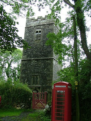
Warbstow is a village and civil parish in Cornwall, England, United Kingdom. The parish has a population of 439 according to the 2001 census, increasing to 520 at the 2011 census.

<span class="mw-page-title-main">St Mabyn</span> Human settlement in England

St Mabyn is a civil parish and village in Cornwall, England, United Kingdom. The village is situated three miles (5 km) east of Wadebridge. The parish includes a hamlet called Longstone to the east and many small manor houses, including Tregarden, Tredethy, Helligan Barton and Colquite, all built in the 16th and 17th centuries. The area of the parish is 4,101 acres (16.60 km2).

<span class="mw-page-title-main">St Agnes, Cornwall</span> Village and civil parish in Cornwall, England

St Agnes is a civil parish and a large village on the north coast of Cornwall, England, United Kingdom. The village is about five miles (8 km) north of Redruth and ten miles (16 km) southwest of Newquay. An electoral ward exists stretching as far south as Blackwater. The population at the 2011 census was 7,565.

<span class="mw-page-title-main">Crowan</span> Village and parish in Cornwall, England

Crowan is a village and civil parish in Cornwall, England, United Kingdom. It is about three-and-a-half miles (6 km) south of Camborne. A former mining parish, all of the mines had shut by 1880.

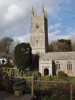
St Kew is a village in Cornwall, England, United Kingdom. It is also the name of the civil parish, which includes the church town, St Kew, and nearby St Kew Highway.

<span class="mw-page-title-main">Helland</span> Human settlement in England

Helland is a civil parish and village in Cornwall, England, United Kingdom. It is situated 2+12 miles (4.0 km) north of Bodmin. The meaning of the name Helland is unclear: it is possible that the origin is in Cornish hen & lan. The original dedication of the church is unknown but St Helena is now recognised as the patron.

<span class="mw-page-title-main">Otterham</span> Human settlement in England

Otterham is a village and a civil parish in north Cornwall, England, United Kingdom. The village is situated approximately ten miles (16 km) south of Bude and six miles (9.7 km) north of Camelford.

<span class="mw-page-title-main">Tremaine, Cornwall</span> Human settlement in England

Tremaine or Tremain is a small village and a rural civil parish in east Cornwall, England, United Kingdom. It is in the Registration District of Launceston and the population in the 2001 census was 87. It had decreased to 53 at the 2011 census. There is also a diary farm called Ash Grove farm.

<span class="mw-page-title-main">Insworke</span> Human settlement in England

Insworke is a hamlet in the parish of Millbrook in southeast Cornwall, England, UK. A fair and annual market were held here from 1319.

<span class="mw-page-title-main">Prospidnick</span> Human settlement in England

Prospidnick is a small village and hill in the parish of Sithney in Cornwall, United Kingdom. It lies 0.6 miles east of Crowntown and 2.6 miles west of Wendron by road. It is divided into Lower Prospidnick and Higher Prospidnick.

<span class="mw-page-title-main">Withielgoose</span> Human settlement in England

Withielgoose or Withel-goose is a hamlet in Cornwall, England, UK. Withielgoose, from the Cornish gwyth (trees), yel and coes (wood) suggests the clearance of woodland to create agricultural land. The hamlet is accessed via Withielgoose Lane and contains Withielgoose Manor. Withielgoose belongs historically to the parish of Withiel along with Retire and Tregawne; the parish had a total population of about 300 in 1824. It lies about five miles west of Bodmin and six miles east north east of St Columb Major.

<span class="mw-page-title-main">St Colanus' Church, Colan</span> Church

Colan Church also known as St Colan Church is a 13th-century church in Colan, mid-Cornwall, UK. Dedicated to St Colanus, it became a Grade I listed building in 1967. The vicars of St Columb Minor have served the church since the middle of the 20th century.

Trenant Park is a Grade II listed country house in the civil parish of Duloe in east Cornwall, England, UK. It is surrounded by a large park and woodland. It is sited on a tongue of land between the East and West Looe rivers. The house was possibly built in the early 17th century, remodelled in the early 18th century, extended in the mid 19th century and divided into flats in the 20th century.

<span class="mw-page-title-main">St James' Church, Jacobstow</span> Church in Jacobstow, England

St James’ Church, Jacobstow is a Grade I listed parish church in the Church of England in Jacobstow, Cornwall.

<span class="mw-page-title-main">St Mary the Virgin's Church, Week St Mary</span> Church in Week St Mary, England

St Mary the Virgin's Church, Week St Mary, also known as the Church of the Nativity of the Blessed Virgin Mary, is a Grade I listed parish church in the Church of England Diocese of Truro, in Week St Mary, Cornwall, England, UK.

<span class="mw-page-title-main">St Anne's Church, Whitstone</span> Church in Whitstone, England

St Anne's Church, Whitstone is a Grade I listed parish church in the Church of England Diocese of Truro in Whitstone, Cornwall, England, UK.

<span class="mw-page-title-main">St Winwaloe's Church, Poundstock</span> Church in Poundstock, England

St Winwaloe's Church, Poundstock is a Grade I listed parish church in the Church of England in Poundstock, Cornwall.

<span class="mw-page-title-main">St Werburgh's Church, Warbstow</span> Church in Cornwall, England

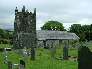
St Werburgh's Church, Warbstow is a Grade II* listed parish church in the Church of England in Warbstow, Cornwall.

<span class="mw-page-title-main">St Gregory's Church, Treneglos</span> Church in Cornwall, England

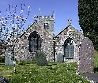
St Gregory's Church, Treneglos is a Grade II* listed parish church in the Church of England in Treneglos, Cornwall.

References

  1. Tregerry Farmhouse, Treneglos. British Listed Buildings. Retrieved 16 September 2012.
  2. Rita Tregellas Pope. Landmark Visitors Guide Cornwall & the Isles of Scilly . Hunter Publishing, Inc; 15 March 2006 [cited 16 September 2012]. ISBN   978-1-84306-211-0. p. 198.
  3. Davies Gilbert. The parochial history of Cornwall: founded on the manuscript histories of Mr. Hals and Mr. Tonkin; with additions and various appendices . J. B. Nichols and son; 1838 [cited 15 September 2012]. pp. 61–62.
  4. Joseph Polsue. A complete parochial history of the county of Cornwall [ed. by J. Polsue]. . 1872 [cited 16 September 2012]. p. 241.
  5. 1 2 Joseph Polsue. A complete parochial history of the county of Cornwall [ed. by J. Polsue]. . 1872 [cited 16 September 2012]. pp. 241–244.
  6. Ashbee, Paul (1958). "The Excavation of Tregulland Burrow, Treneglos Parish, Cornwall". The Antiquaries Journal. 38 (3–4): 174–196. doi:10.1017/S0003581500081932.
  7. Mr Rich Bradley. Rock Art and the Prehistory of Atlantic Europe: Signing the Land . Psychology Press; 20 August 1997 [cited 16 September 2012]. ISBN   978-0-415-16535-8. p. 146–.
  8. Joseph Polsue, ed. A complete parochial history of the county of Cornwall [ed. by J. Polsue]. . 1872 [cited 16 September 2012]. pp. 243–244.
  9. Samuel Drew. The History of Cornwall: From the Earlist Records and Traditions, to the Present Time . W. Penaluna; 1824 [cited 16 September 2012]. p. 638.
  10. John Jeremiah Daniell. A Compendium of the History and Geography of Cornwall . Netherton & Worth; 1906 [cited 16 September 2012]. p. 334.
  11. 1 2 3 Cornish Church Guide (1925) Truro: Blackford; p. 208
  12. 1 2 Church of St Gregory, Treneglos. British Listed Buildings. 16 September 2012.
  13. Cambrian Archaeological Association. Archaeologia Cambrensis: the journal of the Cambrian Archoeological Association . published for the Association by J. R. Smith; 1896 [cited 16 September 2012]. pp. 161–162. Note: drawn image on page 161.
  14. Brown, H. Miles (1964) The Church in Cornwall. Truro: Blackford; pp. 78–83
  15. 1 2 Davies Gilbert. The Parochial History of Cornwall: founded on the manuscript histories of Mr. Hals and Mr. Tonkin; with additions and various appendices . J. B. Nichols and Son; 1838 [cited 15 September 2012]. pp. 22, 61–62.
  16. Treneglos Farmhouse, Treneglos. British Listed Buildings. Retrieved 16 September 2012.
  17. Listed Buildings in Treneglos, Cornwall, England. British Listed Buildings. Retrieved 16 September 2012.
  18. Joseph Polsue, ed. A Complete Parochial History of the County of Cornwall [ed. by J. Polsue]. . 1872 [cited 16 September 2012]. p. 241.
  19. Methodist Church 170 Metres to East of Goads Green, Treneglos. British Listed Buildings. Retrieved 16 September 2012.
  20. Sunday School and Wall and Railings to Front, 170 Metres to North East of Goads Green, Treneglos. British Listed Buildings. Retrieved 16 September 2012.
  21. Davies Gilbert. The Parochial History of Cornwall: founded on the manuscript histories of Mr. Hals and Mr. Tonkin; with additions and various appendices . J. B. Nichols and Son; 1838 [cited 15 September 2012]. p. 63.

Further reading