
Bolventor is a hamlet on Bodmin Moor in Cornwall, England, United Kingdom. It is situated in Altarnun civil parish between Launceston and Bodmin.

Davidstow is a civil parish and village in north Cornwall, England, United Kingdom. The village is north of Bodmin Moor straddling the A395 road about 3 miles (5 km) north of Camelford. The hamlets of Hallworthy, Hendraburnick, Tremail and Trewassa are in the parish. It was formerly known as Dewstow(e).

Advent is a civil parish on the north-western edge of Bodmin Moor in north Cornwall, England, United Kingdom. The English name St Adwenna derives from the Cornish Adhwynn and lies in the Registration District of Camelford.

Lesnewth is a civil parish and village in Cornwall, England, United Kingdom. It is about six miles east of Tintagel Head and two miles east of Boscastle.
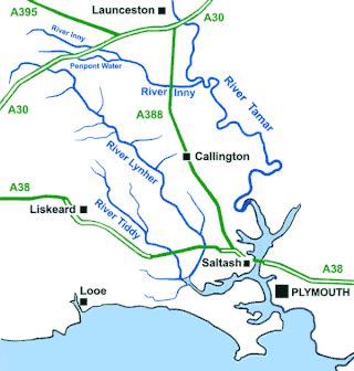
The River Inny is a small river in East Cornwall, England, United Kingdom. A tributary of the River Tamar, the Inny is about twenty miles (32 km) long from its source near Davidstow on the eastern flank of Bodmin Moor to its confluence with the Tamar at Inny Foot near Dunterton.

Lezant is a civil parish and village in east Cornwall, England, United Kingdom. Lezant village is about five miles south of Launceston. The population of the parish in the 2001 census was 751, increasing slightly to 765 in the 2011 census.
Otterham is a village and a civil parish in north Cornwall, England, United Kingdom. The village is situated approximately ten miles (16 km) south of Bude and six miles (9.7 km) north of Camelford.
St Thomas the Apostle Rural, also known as St Thomas-by-Launceston is a civil parish in east Cornwall, England, United Kingdom. It is centred on the village of Tregadillett and is in the Registration District of Launceston.

Tresmeer is a hamlet and a civil parish in northeast Cornwall, England, United Kingdom. The hamlet is situated approximately seven miles (11 km) northwest of Launceston.

Bodbrane is an ancient farmstead hamlet in southeast Cornwall, England, United Kingdom. It is situated about three miles (5 km) south of Liskeard in the civil parish of Duloe.
Croanford is a hamlet in Cornwall, England. It is in the parish of Egloshayle.

Harrowbarrow is a village in the parish of Calstock in east Cornwall, England.
Hendraburnick is a farmstead near Davidstow, Cornwall, England. On Hendraburnick Down is the source of the River Camel.

Horningtops is a hamlet south-southeast of Liskeard in east Cornwall, England in National Grid grid square SX2760. It is in the civil parish of St Keyne and Trewidland.

Langore is a village in Cornwall, England. It is in the parish of St Stephens by Launceston Rural and is about halfway between St Stephens and Egloskerry.
Lower Croan is a farmstead in Cornwall, England, UK. It is in the parish of Egloshayle and Croan house and Croanford are to the east. Croan House is a manor house of two storeys and seven bays which was built in the 1690s for a prosperous attorney.
Muchlarnick is a hamlet in Cornwall, England. It is about two miles east of Lanreath in the civil parish of Pelynt.

Pantersbridge is a hamlet in the parish of St Neot, Cornwall, England, UK. It is about one mile south of Warleggan on the road from St Neot to Cardinham and on the River Warleggan. Early spellings of the name include Pontyesu in 1241 and Ponteisu, circa 1250, Pontewysy in 1359, becoming Pontwise Bridge, or Pontowise bridge by 1613.

Penpoll is a farm in the parish of Quethiock, Cornwall, England, UK. It is near the hamlet of Blunts and north of Tideford Cross. The meaning of Penpoll is "head of a creek".
Penpont is a hamlet in the parish of St Breward, in north Cornwall, England, UK, in the Camel Valley.

