
The Lizard is a peninsula in southern Cornwall, England, United Kingdom. The most southerly point of the British mainland is near Lizard Point at SW 701115; Lizard village, also known as The Lizard, is the most southerly on the British mainland, and is in the civil parish of Landewednack, the most southerly parish. The valleys of the River Helford and Loe Pool form the northern boundary, with the rest of the peninsula surrounded by sea. The area measures about 14 by 14 miles. The Lizard is one of England's natural regions and has been designated as a National Character Area 157 by Natural England. The peninsula is known for its geology and for its rare plants and lies within the Cornwall Area of Outstanding Natural Beauty (AONB).

Porthleven is a town, civil parish and fishing port near Helston in Cornwall, England, UK. As the most southerly port in Great Britain, it was originally developed as a harbour of refuge, when this part of the Cornish coastline was infamous for wrecks in the days of sail. The South West Coast Path from Somerset to Dorset passes through the town. An electoral ward called Porthleven and Helston South also exists. The population at the 2011 census was 3,059. It was estimated to be 3,141 in 2019.

Lizard Point in Cornwall is at the southern tip of the Lizard Peninsula. It is situated half-a-mile (800 m) south of Lizard village in the civil parish of Landewednack and about 11 miles (18 km) southeast of Helston.

Goonhilly Downs is a Site of Special Scientific Interest (SSSI) that forms a raised plateau in the central western area of the Lizard peninsula in southern Cornwall, England, UK. It is one of 229 English national nature reserves designated by Natural England with an area of almost 1,270 hectares.

Aire Point to Carrick Du SSSI is a Site of Special Scientific Interest on the Penwith Peninsula, Cornwall, England. It is 5.98 square kilometres in extent, stretching from grid reference SW360279 to grid reference SW513410. The site is designated both for its biological and its geological interest.

Coverack is a coastal village and fishing port in Cornwall, England. It lies in the parish of St Keverne, on the east side of the Lizard peninsula about nine miles (14 km) south of Falmouth.
Kynance Cove is a cove on the eastern side of Mount's Bay, Cornwall, England. It is situated on the Lizard peninsula approximately two miles (3 km) north of Lizard Point. The cove became popular in the early Victorian era, with many distinguished visitors including Queen Victoria and Prince Albert and the poet Alfred Tennyson. The BBC has described Kynance Cove as "one of the most beautiful stretches of coastline in the South West". The South West Coast Path, which follows the coast of south west England from Somerset to Dorset passes by on the cliffs overlooking the cove.

Mullion is a civil parish and village on the Lizard Peninsula in south Cornwall, England, United Kingdom. The nearest town is Helston approximately 5 miles (8 km) to the north.

Gwennap Head is a headland on the south coast of the Penwith peninsula, Cornwall, United Kingdom. It is within the parish of St Levan and approximately 4 miles (6.4 km) south of Land's End, and less than 1 mile (1.6 km) north-west of Porthgwarra, the nearest village. The area of Gwennap Head is designated as part of the Penwith Heritage Coast and also designated as part of the Cornwall Area of Outstanding Natural Beauty. The South West Coast Path closely follows the coastline around the headland.
Cornwall is the county that forms the tip of the southwestern peninsula of England; this area has a mild and warm climate regulated by the Gulf Stream. The mild climate allows rich plant cover, such as palm trees in the far south and west of the county and in the Isles of Scilly, due to sub-tropical conditions in the summer.
Church Cove is a hamlet in the civil parish of Landewednack in Cornwall, England. Its nearest town is Helston, which lies approximately 10.1 miles (16.3 km) north-west from the hamlet. The parish is notable for being the most southern point on British mainland.

Treen Cliff is a Site of Special Scientific Interest (SSSI) located on the Penwith Peninsula in Cornwall, England, UK, 6 miles (9.7 km) south-west of Penzance. First notified in 1951, with a revision in 1973, and a further notification on 1 July 1986, it is 49.3 hectares in area, stretching from grid reference SW387220 to SW402225. Designated for both for its biological and geological interest, part of the site, Treryn Dinas, is a Scheduled Ancient Monument consisting of a "cliff castle" with four ramparts and ditches and the Logan Rock. It is within the Cornwall Area of Outstanding Natural Beauty (AONB), the Penwith Heritage Coast and is part owned and managed by the National Trust.

Porthallow is a small fishing village on the east coast of The Lizard peninsula to the south of the Helford River, in Cornwall, England, United Kingdom. It sits between the two neighbouring villages of St Keverne and Roskorwell. One road runs through the village, and there is public house, the Five Pilchards, named for the pilchard fishery. Porthallow lies at the midpoint of the South West Coast Path and is within the Cornwall Area of Outstanding Natural Beauty (AONB).
Boscastle to Widemouth is a coastal Site of Special Scientific Interest (SSSI) in Cornwall, England, noted for its biological and geological characteristics. The Dizzard dwarf oak woodland is unique and of international importance for its lichen communities, with 131 species recorded.

Coverack to Porthoustock is a coastal Site of Special Scientific Interest (SSSI) in Cornwall, England, UK, noted for both its biological and geological characteristics. The site contains four Red Data Book plant species.

Godrevy Head to St Agnes is a coastal Site of Special Scientific Interest (SSSI) in north Cornwall, UK, noted for both its biological and geological characteristics. A number of rare and scarce plant species can be found on the site, along with many breeding seabirds.
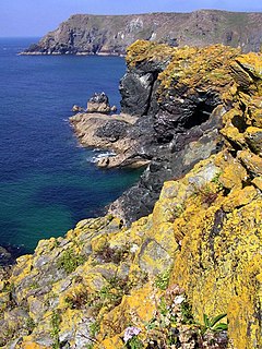
Kennack to Coverack is a coastal Site of Special Scientific Interest (SSSI) on the Lizard Peninsula in Cornwall, England, UK, noted for both its biological and geological interest. It is of botanical importance, with 8 Red Data Book of rare and endangered plant species being found on the site as well as other nationally scarce varieties.

Peninnis Head is the southernmost point of St Mary's, Isles of Scilly. The headland is within the Isles of Scilly Area of Outstanding Natural Beauty and part of the Heritage Coast. It is also a Geological Conservation Review site for its Quaternary geomorphology and was first designated a Site of Special Scientific Interest (SSSI) in 1971 for both its biological and geological interests. On the tip of the headland is a squat lighthouse built in 1911 by Trinity House as a replacement for the 17th century lighthouse on St Agnes.

Zennor Head is a 750-metre (2,460 ft) long promontory on the Cornish coast of England, between Pendour Cove and Porthzennor Cove. Facing the Atlantic Ocean, it lies 1 kilometre north-west of the village of Zennor and 1.6 kilometres east of the next promontory, Gurnard's Head. The granite (Killas) cliffs rise over 200 feet (60 m) from the sea and the highest point of the headland is 314 feet (96 m) above sea level, with an Ordnance Survey triangulation station. Zennor Head is on the South West Coast Path, which follows the cliff edge closely, skirting the entire perimeter of the headland. The promontory is part of the Penwith Heritage Coast, and is the largest coastal feature in the United Kingdom that begins with the letter "Z". It gets its name from a local saint, Senara. Zennor Head was mined for copper and tin in the Victorian Era. There is no longer any residential or commercial occupancy on the headland, but it is occupied by a variety of coastal animals and plants, such as kestrels and gorse.
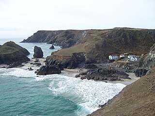
Asparagus Island is a small tidal island on the eastern side of Mount's Bay, within the parish of Mullion, Cornwall, United Kingdom. It lies within Kynance Cove, a popular tourist site on the western side of The Lizard peninsula and is named after the rare wild asparagus (Asparagus prostratus) found there.


