
Mullion is a civil parish and village on the Lizard Peninsula in south Cornwall, England, United Kingdom. The nearest town is Helston approximately 5 miles (8 km) to the north.
The North Devon Coast was designated as an Area of Outstanding Natural Beauty in September 1959. The AONB contributes to a family of protected landscapes in the Southwest of England and a total of 38% of the region is classified by the International Union for Conservation of Nature as Category V Protected Landscapes. The twelve Areas of Outstanding Natural Beauty extend to 30% of the region, twice the proportion covered by AONBs in England as a whole and a further two National Parks, Dartmoor and Exmoor, cover an addition 7%. The North Devon Coast AONB covers 171 square kilometres (66 sq mi) of mainly coastal landscape from the border of Exmoor National Park at Combe Martin, through the mouth of the Taw & Torridge Estuary to the Cornish border at Marsland Mouth. The dune system at Braunton Burrows forms the core area of North Devon's Biosphere Reserve, the first "new style" Unesco-designated reserve in the United Kingdom. The whole of the AONB is within the Reserve boundaries.

Gooseham is a hamlet in northeast Cornwall, England, United Kingdom. It is situated six miles (11 km) north of Bude and is approximately one kilometre south of the border with Devon. The Marsland Valley nature reserve is near the hamlet. It is in the civil parish of Morwenstow, and its size been described by a resident as consisting of just "two houses and a wood rick."

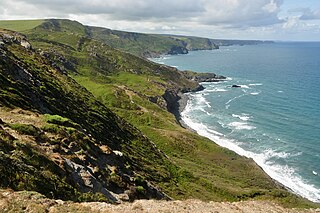
Marsland Valley is a nature reserve situated in two large valleys which straddle the northern end of the Devon-Cornwall border. It is a designated nature reserve jointly managed by the Devon Wildlife Trust and the Cornwall Wildlife Trust. The reserve is a Special Area of Conservation, as well as forming part of two Sites of Special Scientific Interest; Steeple Point to Marsland Mouth on the Cornish side and Marsland to Clovelly Coast in Devon.

The River Ottery is a small river in northeast Cornwall, United Kingdom. The river is about twenty miles (32 km) long from its source southeast of Otterham to its confluence with the River Tamar at Nether Bridge, two miles (3.2 km) northeast of Launceston.

Grimscott is a village in north Cornwall, England, UK. It is situated in the civil parish of Launcells, 3 miles (4.8 km) east of the town of Bude.

Millook is a deep coastal valley and hamlet in the parish of Poundstock, on the north coast of Cornwall, England.

Trevaunance Cove is a small bay on the north Cornish coast and a residential area of St Agnes, Cornwall, United Kingdom. In the 18th and 19th centuries it was a busy harbour despite storms often destroying the quay. The South West Coast Path passes over the coastal slope to the north.

Baulk Head to Mullion is a coastal Site of Special Scientific Interest (SSSI) in Cornwall, England, UK, noted for both its biological and geological characteristics.
Boscastle to Widemouth is a coastal Site of Special Scientific Interest (SSSI) in Cornwall, England, noted for its biological and geological characteristics. The Dizzard dwarf oak woodland is unique and of international importance for its lichen communities, with 131 species recorded.

Caerthillian to Kennack is a coastal Site of Special Scientific Interest (SSSI) on the Lizard Peninsula in Cornwall, UK, noted for both its biological and geological characteristics. It is of great botanical importance, with several Red Data Book of rare and endangered plant species being found on the site, as well as a breeding site for Cornish choughs.

Carricknath Point to Porthbean Beach is a coastal Site of Special Scientific Interest (SSSI) in Cornwall, England, UK, noted for its biological interest.

Coverack to Porthoustock is a coastal Site of Special Scientific Interest (SSSI) in Cornwall, England, UK, noted for both its biological and geological characteristics. The site contains four Red Data Book plant species.

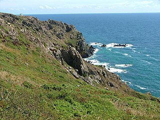
Steeple Point to Marsland Mouth is a coastal Site of Special Scientific Interest (SSSI) in Cornwall, England, UK, noted for its biological characteristics.

Kelsey Head is a coastal Site of Special Scientific Interest (SSSI) and headland in north Cornwall, England, UK, noted for its biological interest. The site contains an Iron Age hill fort.

Gerrans Bay to Camels Cove is a coastal Site of Special Scientific Interest (SSSI) in south Cornwall, England, UK, noted for both its biological and geological interest.
Kennack to Coverack is a coastal Site of Special Scientific Interest (SSSI) on the Lizard Peninsula in Cornwall, England, UK, noted for both its biological and geological interest. It is of botanical importance, with 8 Red Data Book of rare and endangered plant species being found on the site as well as other nationally scarce varieties.
Lymsworthy Meadows is a Site of Special Scientific Interest (SSSI) in north Cornwall, England, UK, noted for its biological characteristics.

Meneage Coastal Section is a coastal Site of Special Scientific Interest (SSSI) in southern Cornwall, England, UK, noted for its geological characteristics.


