
Holkham National Nature Reserve is England's largest national nature reserve (NNR). It is on the Norfolk coast between Burnham Overy Staithe and Blakeney, and is managed by Natural England with the cooperation of the Holkham Estate. Its 3,900 hectares comprise a wide range of habitats, including grazing marsh, woodland, salt marsh, sand dunes and foreshore. The reserve is part of the North Norfolk Coast Site of Special Scientific Interest, and the larger area is additionally protected through Natura 2000, Special Protection Area (SPA) and Ramsar listings, and is part of both an Area of Outstanding Natural Beauty (AONB) and a World Biosphere Reserve. Holkham NNR is important for its wintering wildfowl, especially pink-footed geese, Eurasian wigeon and brant geese, but it also has breeding waders, and attracts many migrating birds in autumn. A number of scarce invertebrates and plants can be found in the dunes, and the reserve is one of the only two sites in the UK to have an antlion colony.

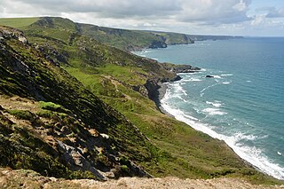
Aire Point to Carrick Du SSSI is a Site of Special Scientific Interest on the Penwith Peninsula, Cornwall, England. It is 5.98 square kilometres in extent, stretching from grid reference SW360279 to grid reference SW513410. The site is designated both for its biological and its geological interest.

Bookham Commons are two commons, situated just to the north of the villages of Great Bookham and Little Bookham, in Surrey, England, 154.7 hectares in extent; the individual parts are named Great Bookham Common and Little Bookham Common. A group of dwellings known as the Isle of Wight is situated within the site, and a track, Common Road, leads to it from the northwest. Little Bookham Common lies south and west of this track, whereas Great Bookham Common lies to the east.

Talland is a hamlet and ecclesiastical parish between Looe and Polperro on the south coast of Cornwall. It is in the civil parish of Polperro and consists of a church, the Old Vicarage and a few houses.

White Island is one of the larger unpopulated islands of the Isles of Scilly, part of the United Kingdom, and lies off the coast of the northernmost populated island of the group, St Martin's, to which it is joined by a tidal causeway, or isthmus. The island is designated as a Site of Special Scientific Interest (SSSI) and a Geological Conservation Review site and is managed by the Isles of Scilly Wildlife Trust on behalf of the Duchy of Cornwall.

Treen Cliff is a Site of Special Scientific Interest (SSSI) located on the Penwith Peninsula in Cornwall, England, UK, 6 miles (9.7 km) south-west of Penzance. First notified in 1951, with a revision in 1973, and a further notification on 1 July 1986, it is 49.3 hectares in area, stretching from grid reference SW387220 to SW402225. Designated for both for its biological and geological interest, part of the site, Treryn Dinas, is a Scheduled Ancient Monument consisting of a "cliff castle" with four ramparts and ditches and the Logan Rock. It is within the Cornwall Area of Outstanding Natural Beauty (AONB), the Penwith Heritage Coast and is part owned and managed by the National Trust.

The Tamar–Tavy Estuary is a Site of Special Scientific Interest (SSSI) covering the tidal estuaries of the River Tamar and the River Tavy on the border between Cornwall and Devon in England, UK. Part of the Tamar estuary also forms the Tamar Estuary Nature Reserve, owned by the Cornwall Wildlife Trust. The site was designated in 1991 for its biodiversity and varying habitats that support many wader and wildfowl species, as well as the special interest of its marine biology.

Red Moor is a nature reserve and Site of Special Scientific Interest (SSSI), noted for its biological characteristics, near Lanlivery in mid Cornwall, England, UK.
Boscastle to Widemouth is a coastal Site of Special Scientific Interest (SSSI) in Cornwall, England, noted for its biological and geological characteristics. The Dizzard dwarf oak woodland is unique and of international importance for its lichen communities, with 131 species recorded.

Caerthillian to Kennack is a coastal Site of Special Scientific Interest (SSSI) on the Lizard Peninsula in Cornwall, UK, noted for both its biological and geological characteristics. It is of great botanical importance, with several Red Data Book of rare and endangered plant species being found on the site, as well as a breeding site for Cornish choughs.

Carricknath Point to Porthbean Beach is a coastal Site of Special Scientific Interest (SSSI) in Cornwall, England, UK, noted for its biological interest.

Steeple Point to Marsland Mouth is a coastal Site of Special Scientific Interest (SSSI) in Cornwall, England, UK, noted for its biological characteristics.

Kelsey Head is a coastal Site of Special Scientific Interest (SSSI) and headland in north Cornwall, England, UK, noted for its biological interest. The site contains an Iron Age hill fort.

Godrevy Head to St Agnes is a coastal Site of Special Scientific Interest (SSSI) in north Cornwall, UK, noted for both its biological and geological characteristics. A number of rare and scarce plant species can be found on the site, along with many breeding seabirds.

The North Norfolk Coast Site of Special Scientific Interest (SSSI) is an area of European importance for wildlife in Norfolk, England. It comprises 7,700 ha (19,027 acres) of the county's north coast from just west of Holme-next-the-Sea to Kelling, and is additionally protected through Natura 2000, Special Protection Area (SPA) listings; it is also part of the Norfolk Coast Area of Outstanding Natural Beauty (AONB). The North Norfolk Coast is also designated as a wetland of international importance on the Ramsar list and most of it is a Biosphere Reserve.

Leckhampton Hill and Charlton Kings Common is a 63.8-hectare (158-acre) biological and geological Site of Special Scientific Interest in Gloucestershire, notified in 1954. There are five units of assessment.
Shorn Cliff And Caswell Woods is a 69.2-hectare (171-acre) biological Site of Special Scientific Interest in Gloucestershire, notified in 1986. The site is listed in the 'Forest of Dean Local Plan Review' as a Key Wildlife Site (KWS).

The name East Caithness Cliffs refers to weathered sandstone cliffs on the east coast of Caithness in Scotland. The cliffs, which rise to 150 m at Berriedale, provide ideal nesting conditions for breeding seabirds, and are protected by several overlapping conservation designations:

Quarry Moor is a Site of Special Scientific Interest, or SSSI, at the south edge of Ripon, North Yorkshire, England, and adjacent to the A61 road. It contains an outcrop of Magnesian Limestone, exposed by former quarrying. 255 million years ago this limestone was the peripheral sediment of a tropical sea. The land was donated in 1945 to the people of Ripon by the town's mayor, Alderman Thomas Fowler Spence, a varnish manufacturer. The land was notified as an SSSI in 1986 because its calcareous grassland supported a large diversity of plant species. The site features a Schedule 8 protected plant, thistle broomrape. The land is protected as a nature reserve, and it is also managed as a recreational area. Therefore, its calcareous grass area is fenced off for protection and study, but it also contains a car park, information signs, a children's play area, accessible paths, benches, and dog waste bins.

Hatherton Flush is a Site of Special Scientific Interest (SSSI) by the River Weaver in Hatherton, near Wybunbury, Cheshire, England. It is protected for its variety of wetland plants. Species found at the site include the locally rare plants marsh helleborine, marsh lousewort and tubular water dropwort. Hatherton Flush is the largest example of this kind of flush in the county. The site was assessed as being in an "unfavourable"/"recovering" condition in 2008.


